Ardnamurchan Central Complex 1:25,000 geological map. British Geological Survey, 2009. Richey, J.E. and Thomas, H.H. 1930. The geology of Ardnamurchan, north-west Mull and Coll. Memoir for geological sheet 51, part 52 (Scotland). Edinburgh: [HMSO for the Geological Survey]

The geology of Ardnamurchan, north-west Mull and Coll. Memoir for geological sheet 51, part 52 (Scotland)

By J. E. Richey and H. H. Thomas

British Geological Survey

The geology of Ardnamurchan, north-west Mull and Coll. Memoir for geological sheet 51, part 52 (Scotland) by J. E. Richey, MC, BA, and H. H. Thomas, MA, ScD, FRS with contributions by E. B. Bailey, MC, MA, FRS, J. B. Simpson, BSc, V. A. Eyles, BSc, and G. W. Lee, DSc and chemical analyses by E. G. Radley, FCS, and B. E. Dixon, MSc, AIC

Edinburgh His Majesty's Stationery Office 1930. 1987 reprint

Her Majesty's Stationery Office. First published 1930 by HMSO. Second impression 1987 issued by BGS

Printed in the UK for BGS by Derry and Sons Ltd, Nottingham. C5 6/87 ISBN 0 85272 095 5

British Geological Survey Keyworth, Nottinghamshire NG12 5GG Plumtree (060 77) 6111

Murchison House, West Mains Road, Edinburgh EH9 3LA (031) 667 1000

(Front cover)

(Figure 23) Map of Outer Cone-sheets of Centre 2, shore south of Kilchoan

The full range of Survey publications is available through the Sales Desks at Keyworth and Murchison House. Selected items are stocked by the Geological Museum Bookshop, Exhibition Road, London SW7 2DE; all other items may be obtained through the BGS London Information Office in the Geological Museum ((01) 589 4090). All the books are listed in HMSO's Sectional List 45. Maps are listed in the BGS Map Catalogue and Ordnance Survey's Trade Catalogue. They can be bought from Ordnance Survey Agents as well as from BGS.

The British Geological Survey carries out the geological survey of Great Britain and Northern Ireland (the latter as an agency service for the government of Northern Ireland), and of the surrounding continental shelf as well as its basic research projects. It also undertakes programmes of British technical aid in geology in developing countries as arranged by the Overseas Development Administration.

The British Geological Survey is a component body of the Natural Environment Research Council.

(Front cover)

Preface

The area dealt with in this Memoir is represented by Sheet 51 of the Geological Map (one inch to one mile) and part of Sheet 52. It includes the Island of Coll, the North-west of Mull, and the western part of the peninsula of Ardnamurchan.

The Survey of Mull was completed by Mr. Bailey and his staff in 1920, and accounts of the Tertiary and pre-Tertiary rocks of the island were published in 1924 and 1925 respectively. In the autumn of 1920 Mr. Richey commenced work in Ardnamurchan and continued in subsequent years the mapping of the Tertiary igneous complex. For a short period he had the assistance of Mr. Bailey and Mr. Simpson. The detailed survey of the Tertiary and pre-Tertiary rocks of Ardnamurchan was completed in 1923. In 1921 Mr. Bailey, with Messrs. Eyles and Simpson, completed the mapping of Coll. In 1924 Mr. Richey and Dr. Thomas revisited Ardnamurchan to investigate further the relative ages of individual intrusions in the light of evidence furnished by the microscopic petrology. Concurrently with the surveying, chemical analyses were prepared by Mr. Radley and Mr. Dixon of the ancient rocks of Coll and of the Tertiary igneous rocks of Ardnamurchan. Mr. Manson was responsible for the collection of fossils from the Mesozoic rocks, for rock collection, more especially during several traverses across portions of the Ardnamurchan igneous complex, and for the taking of the geological photographs to illustrate the Ardnamurchan district.

In the present Memoir Mr. Bailey, with Mr. Simpson and Mr. Eyles, has written an account of the Island of Coll; details of the geology of North-west Mull have been drawn from the published memoirs on that island; and the account of Ardnamurchan, as also the Memoir-map, is mainly the work of Mr. Richey. Dr. Thomas, working in close co-operation with Mr. Richey, is responsible for the petrology of the Tertiary igneous rocks.

The account of the palaeontology of the Mesozoic rocks of Ardnamurchan was written by Dr. Lee, who unfortunately has not lived to see the publication of his work. His manuscript has been edited by Mr. J. Pringle, his successor in the Palaeontological Department in Edinburgh.

The area surveyed and described by each officer who had been engaged in the district is indicated by the initials placed at the end of the various paragraphs. Similarly, palxontographical matter carries the initials of the late Dr. Lee, and the petrology those of the Petrographer.

The Tertiary igneous complex of Ardnamurchan is more or less equally divided between Sheets 51 and 52 of the Geological Map. Sheet 51 is wholly surveyed, and has been published, but the surveying of Sheet 52 is not yet complete. In order, therefore, that the Tertiary complex should be presented as a unit, a special Memoir-map has been prepared on a scale of one and a half miles to an inch, and is inserted in a pocket at the end of the volume.

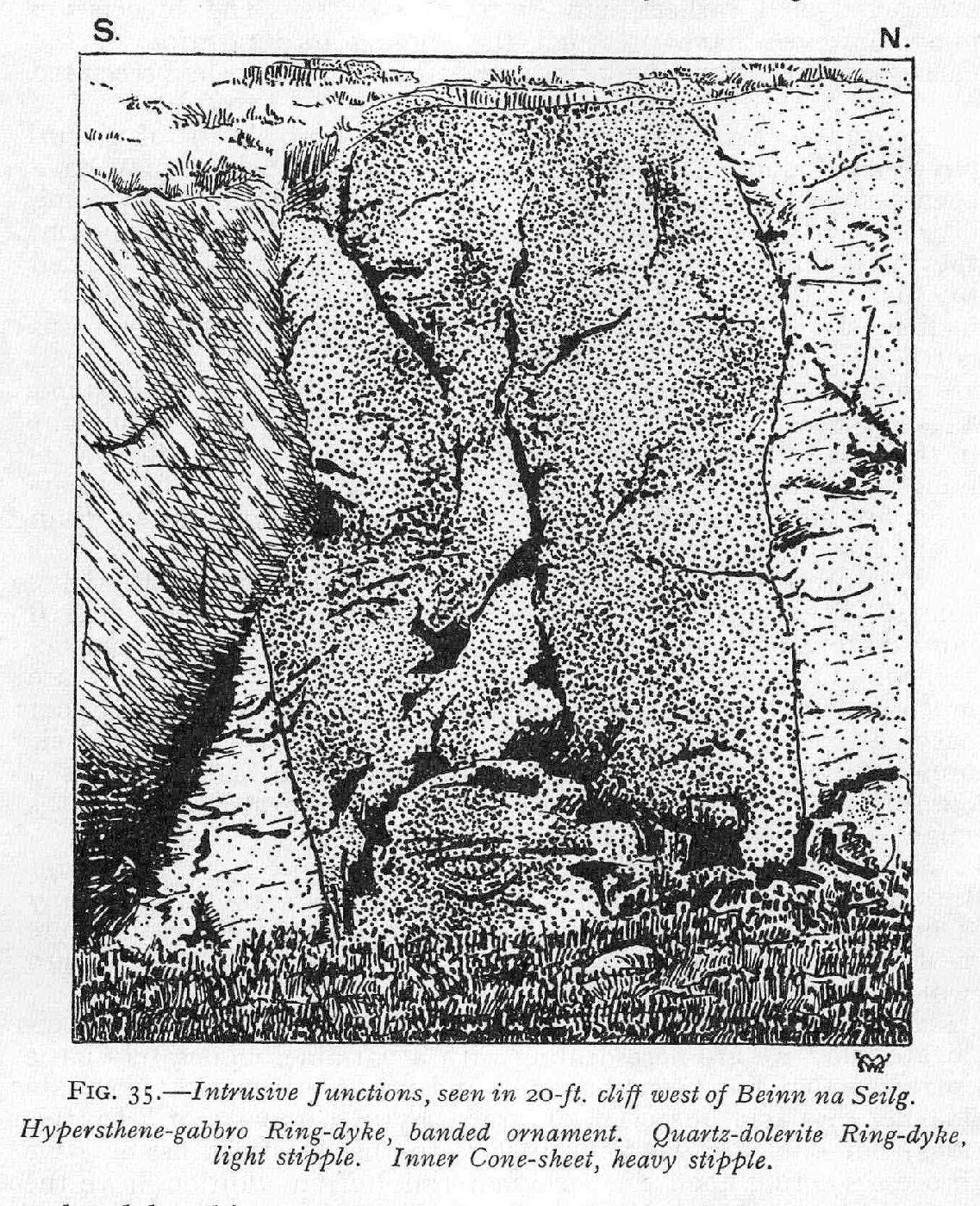
The district is of special value, as it illustrates in a comparatively simple manner many of the remarkable and important features of British Tertiary intrusive activity that attained its grandest expression in Skye and Mull. It is remarkable for the number and variety of its successive episodes, and illustrates more particularly the centralized intrusion of ring-dykes and cone-sheets, while the almost entire absence of glacial deposits has contributed largely to the excellence of rock-exposures.

J. S. Flett, Director. Geological Survey Office, 28 Jermyn Street, London, S.W. 1, 15th May 1930.

Contents

Preface

List of illustrations

Chapter 1. Introduction

Chapter 2 Lewisian Complex of Coll

Chapter 3 Moine Schists of Ardnamurchan

Chapter 4 Trias and Jurassic, Ardnamurchan and North-west Mull

Chapter 5 Review of Tertiary Igneous Activity in Britain

Chapter 6 Tertiary Igneous Rocks, Ardnamurchan, History of Research

Chapter 7 Tertiary Igneous Rocks, Ardnamurchan and North­west Mull, Time Sequence

Chapter 8 Tertiary Igneous Rocks, Ardnamurchan, General Petrology

Chapter 9 Tertiary Basal Sediments, Ardnamurchan

Chapter 10 Tertiary Basalt Lavas, North-west Mull and Ardnamurchan

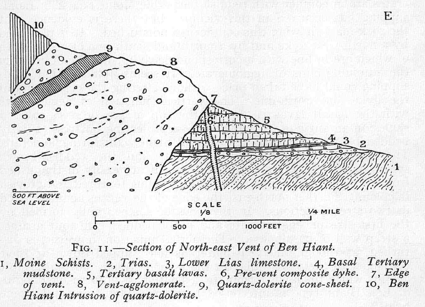
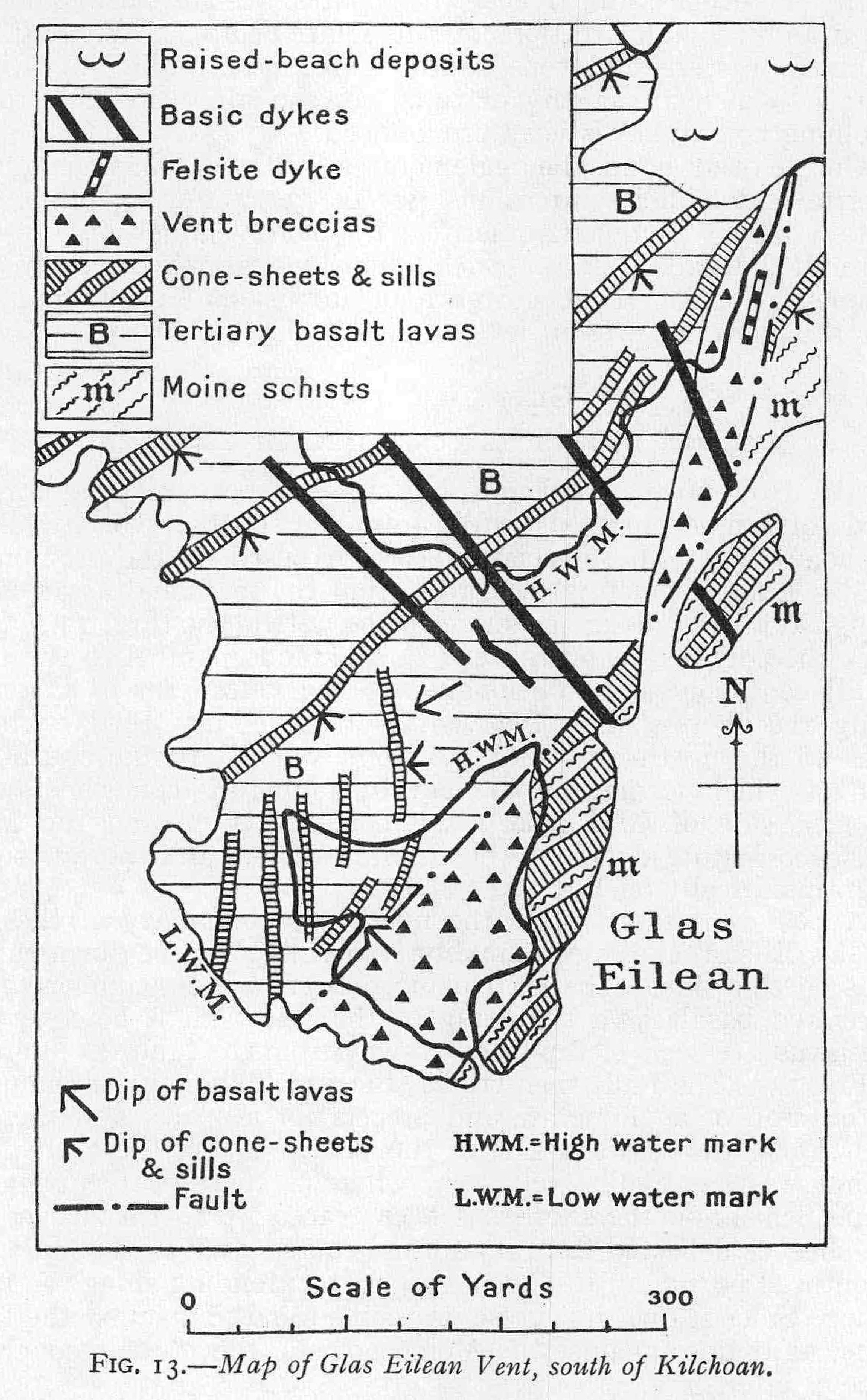
Chapter 11 Tertiary Volcanic Vents, Centres 1 and 2, Ardnamurchan

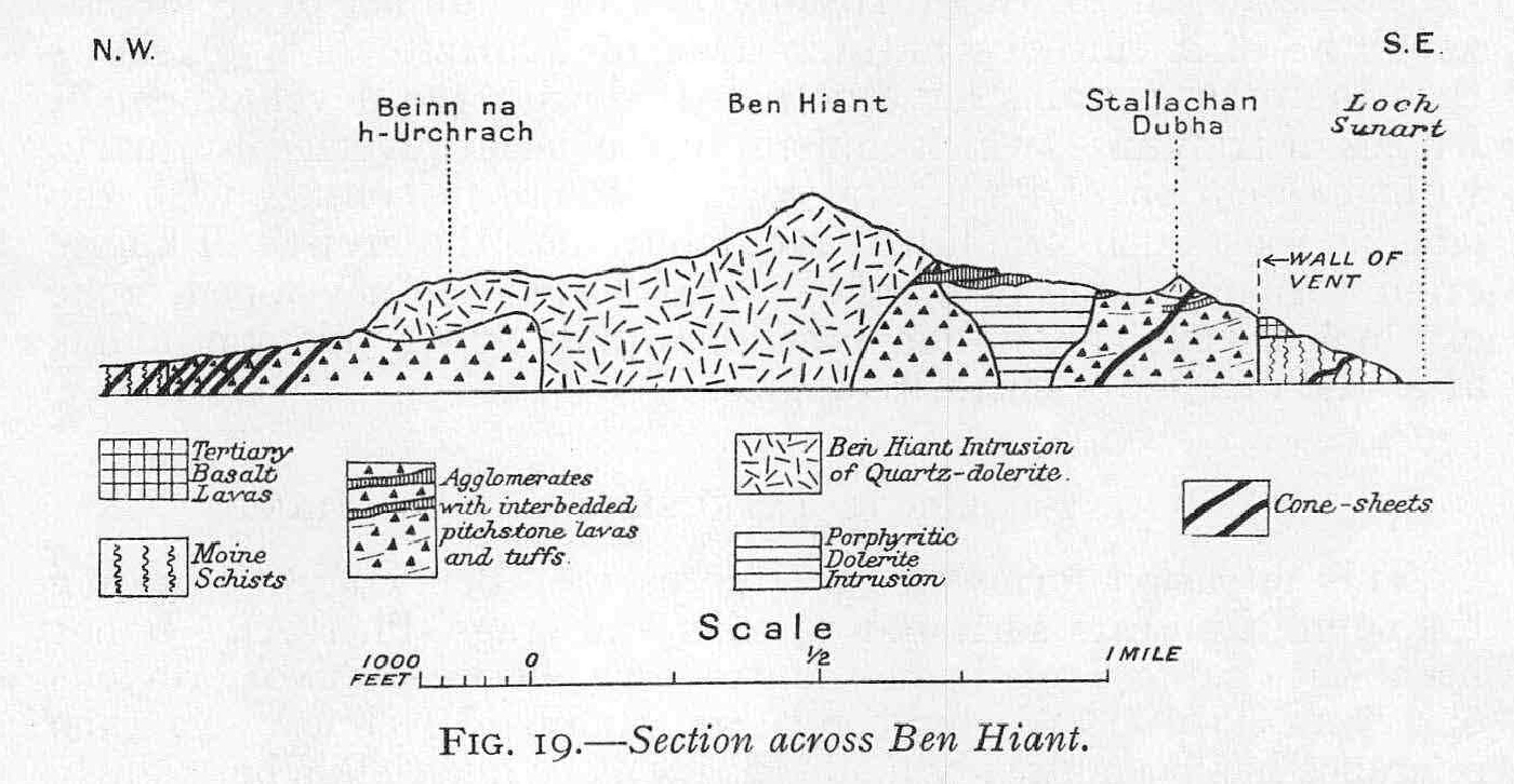
Chapter 12 Tertiary Major Intrusions, Centre t, Ardnamurchan

Chapter 13 Tertiary Major Intrusions, Centre t, Ardnamurchan

Chapter 14 Tertiary Cone-sheets, Centres I, 2, and 3, Ardnamurchan

Chapter 15 Tertiary Ring-dykes of Ardnamurchan, Introduction

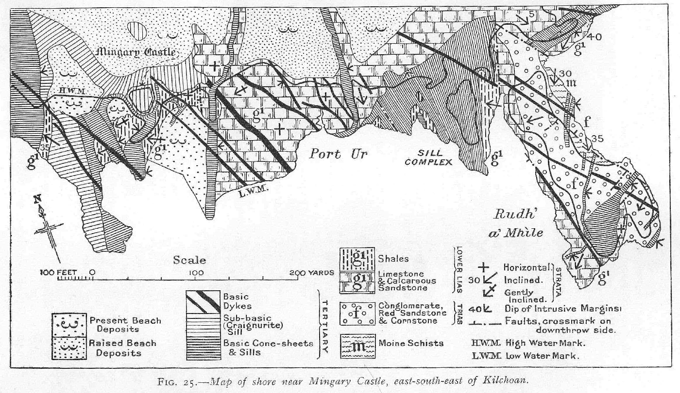
Chapter 16 Tertiary Ring-dykes of Centre 2, Ardnamurchan

Chapter 17. Tertiary Ring-dykes of Centre 2, Ardnamurchan (continued)

Chapter 18. Tertiary Ring-dykes of Centre z, Ardnamurchan

Chapter 19. Tertiary Ring-dykes of Centre 3, Ardnamurchan

Chapter 20. Tertiary Ring-dykes of Centre 3, Ardnamurchan

Chapter 21. Tertiary Ring-dykes of Centre 3, Ardnamurchan

Chapter 22 Tertiary Dykes, Ardnamurchan and North-west Mull

Chapter 23 Dykes of Coll

Chapter 24. Tertiary Basic Plugs and Sheets of North-west Mull

Chapter 25. Close of Tertiary Igneous Period to Recent

Chapter 24 Economics

Appendix 1. Itineraries

Appendix 2 List of Geological Survey Photographs, Ardnamurchan

Appendix 3 Bibliography

Index

List of illustrations

Figures in text

(Figure 1) Map of Coll and Tiree

(Figure 2) Map illustrating structural disposition of Schists of Ardnamurchan, east of Kilchoan and Kilmory

(Figure 3) Map of Mesozoic strata and Tertiary basalt lavas cut by Tertiary minor intrusions, west of Kilchoan Bay

(Figure 4) Map showing distribution of Tertiary north-west dykes in relation to Tertiary Intrusive Complexes of the British Isles

(Figure 5) Stereogram representing diagrammatically the Cone-sheet Complexes of Centre 2, Ardnamurchan, and inferred magma-reservoir

(Figure 6) Variation-Diagram: Normal Magma-Series

(Figure 7) Variation-Diagram: Porphyritic Central Magma-Type .

(Figure 8) Variation-Diagram: Tonalite and Quartz-monzoiaite Magma‑Series

(Figure 9) Tertiary basalt lavas overlying knob of sandstone, Bloody Bay, Mull

(Figure 10) Map of Vent-Complex, eastern side of Ben Hiant

(Figure 11) Section of North-east Vent of Ben Hiant

(Figure 12) Vent-agglomerate near Maclean's Nose, Ben Hiant

(Figure 13) Map of Glas Eilean Vent, south of Kilchoan

(Figure 14) Microsections: Acid types from vents

(Figure 15) Microsections: Pitchstone, Ben Hiant

(Figure 16) Section, west of Faskadale Bay

(Figure 17) Microsections: Augite-diorite of Camphouse

(Figure 18) Microsections: Composite Intrusion of Beinn an Leathaid

(Figure 19) Section across Ben Hiant

(Figure 20) View of Ben Hiant from east

(Figure 21) Cliff of columnar Variolite, Ben Hiant

(Figure 22) Microsections: Quartz-dolerite and Variolite, Ben Hiant Intrusion

(Figure 23) Map of Outer Cone-sheets of Centre 2, shore south of Kilchoan

(Figure 24) Section along line A, B, of (Figure 23)

(Figure 25) Map of shore near Mingary Castle, Kilchoan

(Figure 26) Microsections: Composite Intrusion of Sròn Bheag

(Figure 27) Section across Ardnamurchan igneous complex

(Figure 28) Section across south-west part of Ardnamurchan igneous complex

(Figure 29) Microsections: Hypersthene-gabbro

(Figure 30) Microsections: Acidification of Hypersthene-gabbro and an associated granulite

(Figure 31) Microsections: Granulites in Ring-dykes

(Figure 32) Microsections: Sapphire and Spinel rocks

(Figure 33) Microsections: Grigadale Granophyre, and Quartz-dolerite of Sgizr nam Meann

(Figure 34) Quartz-dolerite net-veined by granophyre, Sgfirr nam Meann Ring-dyke

(Figure 35) Intrusive junctions west of Beinn na Seilg

(Figure 36) View of western side of Beinn na Seilg

(Figure 37) Map of portion of Ring-dyke Complex of Centre 2, north of Beinn nan Ord

(Figure 38) Microsections: shattered Eucrite of Beinn nan Ord

(Figure 39) Section from Meall an Tarmachain to Glas Bheinn

(Figure 40) View of Meall nan Con and Meall Meadhoin from north

(Figure 41) View of crags on west side of Meall nan Con

(Figure 42) Microsections: Great Eucrite

(Figure 43) Microsections: Olivine-spinel-granulite

(Figure 44) Intrusive junction of Quartz-gabbro of Meall an Tarmachain summit with Outer Eucrite

(Figure 45) Microsections: deschillered augite and albitized felspar 46 Map of south portion of Interior Complex of Ring-dykes off Centre 3

(Figure 47) Diagrammatic section across &the= MOT Ring-dyke

(Figure 48) Microsections: Tonalite and Quartz-Tnonzornte

(Figure 49) Tertiary Dykes of the South-West Highlands

(Figure 50) Map of Tertiary Dykes, Ardnarmarchan

(Figure 51) Map of dykes and cone-sheets on shore west of Sron Eheag

(Figure 52) Microsections: Dyke Rocks

(Figure 53) Map of general glaciation of district, and some raised-beach phenomena

(Figure 54) View of Kilehoan Bay from east, showing Pre-Glacial Marin3 Rock-notch at 140 ft.

Plates

(Plate 1) A. View of Ben Hiant, Ardnamurchan, from west B. Marginal scarp of Ben Hiant Intrusion. Frontispiece

(Plate 2) Index Map of Tertiary Intrusive Complexes of Centres 1, 2, and 3, Ardnamurchan

(Plate 3) A. View of Maclean's Nose, Ardnamurchan, from east B. Agglomerate cliffs of Maclean's Nose

(Plate 4) Quartz-dolerite Cone-sheets along shore, south of Kilchoan, Ardnamurchan

(Plate 5) Index Map of Ring-dykes of Centres 2 and 3, Ardnamurchan

(Plate 6) Panorama of Interior Complex of Ring-dykes of Centre 3, Ardnamurchan, from north­east

(Plate 7) Tertiary Gabbro Topography, Ardnamurchan. View looking south from Achosnich

(Plate 8) Map of Tertiary Igneous Complex of Ardnamurchan

Explanation of plates

(Plate 1), a. View of Ben Hiant, Ardnamurchan, from west. Main mass of this rocky hill is Ben Hiant Intrusion (see (Figure 19), p. 160). Maclean's Nose to right is agglomerate. Junction of these rocks extends from shore up well-marked hollow, seen on photograph above Mingary Castle (see also (Plate 1) B). Stallachan Dubha is formed of outlying portion of Ben Hiant Intrusion. Scarp-features in middle distance are due to cone-sheets. Mingary Castle stands on a craignurite sill. Promontory beyond is Rudha a' Mhìle ((Figure 25), p. 177). Geological Survey Photograph, No. C. 2829. B. Marginal Scarp of Ben Want Intrusion, seen from south-east. The view is taken from west of Stallachan Dubha (see Plate 1, A and Explanation). The Ben Hiant Intrusion is closely jointed. Vent-agglomerate forming foreground contains two large masses of big-felspar basalt (p. 126), one in centre of view, the other to the left. Geological Survey Photograph, No. C2850.

(Plate 3) A. View of Maclean's Nose, Ardnamurchan, from east. Cliffs extend up to 800 ft. above sea-level, and are formed of vent-agglomer­ate with flatly interbedded tuffs. On extreme right of scree, buttress of basalt lava marks a vertical wall of the vent. Exposure of vent-wall (Moine Schist) again occurs on shore near point of Nose (see p. 124). Geological Survey Photograph, No. C2859. B. Agglomerate Cliff of Maclean's Nose. In foreground, flat bed of tuff (below hammer) with agglomerate above and below. The view is taken from near extreme right of (Plate 3) A, looking towards the Nose. Geological Survey Photograph, No. C2848.

(Plate 4) Quartz-dolerite cone-sheets along shore south of Kilchoan, Ardnamurchan. The cone-sheets are inclined away from the camera, and show well-developed cross-jointing. (See (Figure 23), p. 174.) Geological Survey Photograph, No. C2826.

(Plate 7) Tertiary Gabbro Topography, Ardnamurchan. View looking south from Achosnich across Ring-dyke Complex of Centre 2. Beinn na Seilg and Beinn nan Ord are formed mainly of eucrite. Intervening valley is eroded along north-south crush-lines. Dubh Chreag and other distant hills are hypersthene-gabbro. Lower ground between Beinn na Seilg and crofts in foreground (Achosnich) is mainly quartz-gabbro. Geological Survey Photograph, No. C2785.

(Figure 1) — Map of Coll and Tiree.

(Figure 2) Map illustrating structural disposition of Schists of Ardnamurchan, east of Kilchoan and Kilmory. East of the dotted line rrthe Schists are folded about north-west axes and are often vertical. West of the line, their strike is irregular and their dip seldom over 30°. The approximate line of junction of the Kilchoan Moines with the Eastern Schists lies a short distance west of the dotted line, extending from the north end of Loch Mudle southwards to cross the road due east of Beinn nan Losgann. Farther south, the two series of schists are separated by the Tertiary igneous rocks of Ben Hiant.

(Figure 3) Map of Mesozoic strata and Tertiary basalt lavas cut by Tertiary minor intrusions, west of Kilchoan Bay. Note. Tertiary cone-sheets are mainly represented diagrammatically.

(Figure 4) Map showing distribution of Tertiary north-west basic dykes in relation to Tertiary central intrusive complexes of the British Isles. Note: number of dykes is greatly reduced.

(Figure 5) Stereogram representing diagrammatically the Cone-sheet Complexes of Centre 2, Ardnamurchan, with reference to their inferred magma-reservoir.

(Figure 6) Variation-diagram, Normal Magma-Series.

(Figure 7) Variation diagram, Porphyritic Central Magma-Type.

(Figure 8) Variation diagram, Tonalite and Quartz-monzonite Magma-Series.

(Figure 9) Tertiary basalt lavas overlying a knob of sandstone at Bloody Bay, Northern Mull. Quoted from Summary of Progress for two, p. 37.

(Figure 10) Map of Vent-Complex, eastern side of Ben Hiant. Geology of Ardnamurchan.

(Figure 11) Section of North-east Vent of Ben Hiant.1, Moine Schists. 2, Trims. 3, Lower Lias limestone. 4, Basal Tertiary mudstone. 5, Tertiary basalt lavas. 6, Pre-vent composite dyke. 7, Edge of vent. 8, Vent-agglomerate. 9, Quartz-dolerite cone-sheet. 10, Ben Hiant Intrusion of quartz-dolerite.

(Figure 12) Vent-agglomerate with large blocks of big-felspar basalt, near Maclean's Nose, Ben Hiant. Drawn from Geological Survey Photograph No. C. 2843.

(Figure 13) Map of Glas Eilean Vent, south of Kilchoan.

(Figure 14) Acid types from the Vents. A (S21446) [NM 5328 6183] &mu 20. Rhyolite with well-developed fluxion-structure, from the Agglomerate of Maclean's Nose, Ben Hiant. B (S23599) [NM 520 706] × 20. Spherulitic Quartz-rhyolite from East of Achateny Water. Showing phenocrysts of quartz surrounded by spherulitic growths of quartz and alkali felspar, in a devitrified felsitic matrix.

(Figure 15) Pitchstones of Ben Hiant. A. (S21255) [NM 540 622] × 20. Normal type. Porphyritic plagioclase and small crystals of enstatite-augite in a glassy base charged with crystallites. B. (S21458) [NM 5426 6272] × 20. Glomeroporphyritic group of hypersthene, augite, and plagioclase felspar in a brown glassy base.

(Figure 16) Section, west of Faskadale Bay. 1. Basalt lava in vent. 2. Vent-agglomerate. 3. Screen of vent-agglomerate separating intrusions 4 and 5. 4. Gabbro of Centre 1. 5. Granophyre of Centre 1. 6. Basic E.N.E. dyke, seen to cut some cone-sheets and to be cut by others. 7. Cone-sheets of Centre 2. E, Great Eucrite Ring-dyke of Centre 3. L.W.M., Low-water Mark.

(Figure 17) Augite-diorite of Camphouse. A. (S22226) [NM 5207 6433] × 6. Felspathic variety. Idiomorphic crystals of augite with deep-brown or grass-green margins, partially albitized labradorite and perthitic orthoclase rich in apatite. B. (S21512) [NM 5207 6433] × 20. Portion of same mass showing a less alkaline and more doleritic facies.

(Figure 18) Composite Intrusion of Beinn an Leathaid. A. (S23463) [NM 5203 6772] × 20. Lower basic portion of intrusion. The rock is composed of well-shaped crystals of zoned labradorite-andesine felspar, aluminous and non-aluminous augite, and a little hornblende in a matrix of alkali felspar and quartz. B. (S23459) [NM 5190 6767] X 34. Acid upper portion of the intrusion. The section shows phenocrysts of acid-plagioclase felspar with subordinate ferromagnesian minerals in a fine-textured base that appears mainly to represent devitrified glass.

(Figure 19) Section across Ben Hiant.

(Figure 20) View of Ben Hiant from east, in, Moine Schists. B, Tertiary basalt lava. V, Vent-agglomerate. qD, Ben Hiant Intrusion.

(Figure 21) Twenty-foot cliff of columnar variolite (part of Ben Hiant Intrusion), traversed by crush-line, southwest side of Ben Hiant. Drawn from Geological Survey Photograph No. C. 2852.

(Figure 22) Ben Hiant Intrusion. A. (S22296) [NM 5325 6252] × 20. Quartz-dolerite. The section shows partly decomposed olivine, labradorite felspar, augite, and ilmenite in a matrix of skeletal felspars, acicular augite, quartz and iron-ore. B. (S24235) [NM 531 630] × 20. Variolite. Small phenocrysts of labradorite felspar in a base consisting of blade-like crystals of yellowish-brown augite, long rods of magnetite, and a fine feathery crystallization of oligoclase-andesine felspar.

(Figure 23) Map of Outer Cone-sheets of Centre 2, shore south of Kilchoan.

(Figure 24) Section along line A-B of (Figure 23) (Map of Outer Cone-sheets of Centre 2, shore south of Kilchoan).

(Figure 25) Map of shore near Mingary Castle, east-south-east of Kilchoan.

(Figure 26) Composite Intrusion of Sròn Bheag A. (S21825A) [NM 4657 6228] × 20. Basic central portion of intrusion originally a quartz-dolerite of Talaidh type. Now modified by the intrusion of acid material and the consequent development of biotite. The rock retains its doleritic texture (see below). B. (S21827) [NM 4652 6227] × 20. Acid portion of the same mass consisting mainly of alkali-felspar, both soda and potash varieties, quartz, and fairly large crystals of fox-red biotite.

(Figure 27) Section across Tertiary Intrusive Complex of Ardnamurchan. Index-letters for ring-dykes are explained in (Table 7), pp. 201–202.

(Figure 28) Section across south-west part of Ardnamurchan Igneous Complex. 1, Highland Schists. 2, Trias. 3, Lias. 4, Inferior Oolite (limestone and sandstone). 5, Tertiary basalt lavas. 6, Outer, and 7, Inner, Cone-sheets of Centre 2. Ring-dykes a, c, e, f, g, and A as lettered on (Plate 5)., p. 201.

(Figure 29) Hypersthene-gabbro. A. (S23625) [NM 4499 6364] × 20. Hypersthene-gabbro. Large crystals of olivine fringed with hypersthene and embedded In a matrix of basic plagioclase felspar. B. (S22376) [NM 4195 6705] × 20. Olivine-free variety of the Hypersthene-gabbro showing ophitic relations of hypersthene and labradorite.

(Figure 30) Acidification of Hypersthene-gabbro. A. (S21522) [NM 4716 6440] × 20. Acidified gabbro. The section shows partly resorbed augite, plagioclase felspars albitized and edged with alkali-felspar, and some iron-ore, in a copious granophyric matrix. B. (S22274) [NM 4416 6942] × 20. Granulitic mass presumably produced by the complete assimilation of gabbro material by acid magma. The rock contains a green strongly pleochroic augite, similar to that encountered in the Camphouse Augitediorite (p. 153, (Figure 17)).

(Figure 31) Granulitic masses associated with basic ring-dykes.. A. (S22658) [NM 4986 6764] × 20. Granulitic gabbro, at margin of Great Eucrite south-west of Meall nan Con. A completely recrystallized rock composed of augite, clear plagioclase, and abundant iron-ore. All the constituents tend to have a granulitic development. B (S23620) [NM 4223 6631] × 20. Granulitic gabbro of allivalitic composition, enclosed by Hypersthene-gabbro. It is composed of granulitic olivine, basic plagioclase felspar, and iron-ore. The rock has been completely recrystallized and has developed a faint banding.

(Figure 32) A (S24490 B) [NM 4805 6478] × 20. Sapphire-spinel rock xenolithic in the Hypersthene-gabbro. The section shows well-formed crystals of corundum and an almost opaque spinellid in a chloritic base. B (S24440) [NM 4283 6815] × 20. Spinel-magnetite rock occurring as streaks in the Quartz-dolerite of Sgùrr nam Meann. The section shows well-shaped crystals of dark-green spinel containing skeletal growths of magnetite, set in a matrix largely composed of magnetite. Certain bands contain a basic plagioclase felspar of which a little is visible in the lower portion of the section.

(Figure 33) Granophyre of Grigadale and Quartz-dolerite of SgUrr nam Meann. A. (S22820) [NM 437 664] × 20. Grigadale Granophyre. Crystals of plagioclase edged with turbid alkali felspar, partially resorbed augites of gabbro origin, and occasional patches of iron-ore, in a granophyric matrix of alkali felspar and quartz. B. (S22409) [NM 432 662] × 20. Quartz-dolerite of Sgùrr nam Meann. The section shows a large crystal of hypersthene, with partially recrystallized augite and iron-ore, in a matrix of plagioclase felspar that has been invaded by acid material and locally albitized.

(Figure 34) Quartz-dolerite net-veined by granophyre, Sgùrr nam Meann Ring-dyke, on shore south-west of Sgitrr nam Meann. Drawn from Geological Survey Photograph, No. C. 2773.

(Figure 35) Intrusive Junctions, seen in 20-ft. cliff west of Beinn na Seilg. Hypersthene-gabbro Ring-dyke, banded ornament. Quartz-dolerite Ring-dyke, light stipple. Inner Cone-sheet, heavy stipple.

(Figure 36) View of the western side of Beinn na Seilg. a, Hypersthene-gabbro. c, Quartz-gabbro of Garbh-dhail. e, Quartz-dolerite of Sgitrr nam Meann. f, Eucrite of Beinn nan Ord. g′, Quartz-gabbro of Beinn na Selig. Broken lines indicate margins of ring-dykes (not shown in foreground).

(Figure 37) Map of portion of Ring-dyke Complex of Centre 2, north of Beinn nan Ord. Note. Localities of a serial collection of rock-specimens are indicated by black dots numbered 1–21 (see pp. 268–270, 274, 275).

(Figure 38) Eucrite of Beinn wan Ord. A. (S22397) [NM 432 662] × 20. Irregularly bounded and broken crystals of olivine with some augite in a felspathic matrix. Ordinary light. B. (S22397) [NM 432 662] × 20. The same field between crossed nicols, showing the shattered character of the matrix. Subsequent metamorphism attended by recrystallization has, to a certain extent, reduced the original intensity of the cataclastic structures.

(Figure 39) Section from Meall an Tarmachain to Glas Bheinn, north of Kilchoan. 1, Moine Schists. 2, Trias. 3, Lower Lias (limestone and shale). 4, Tertiary basalt lavas. 5, Vent-agglomerate (Centre 1). 6, Porphyritic Dolerite of Glas Bheinn (Centre 1). 7, Outer Cone-sheets of Centre 2. 8, Cone-sheets (Centre 3). 9, Quartz-felsite dyke. A, Quartz-gabbro Ring-dyke (Centre 3). E, Great Eucrite Ring-dyke (Centre 3).

(Figure 40) View of Meall nan Con and Meall Meadhoin from north.Dotted line indicates junction of Meall nan Con Screen, forming ridge to left, with Great Eucrite Ring-dyke, forming Meall Meadhoin and foreground. Drawn from Geological Survey Photograph No. C. 2818.

(Figure 41) View of crags on west side of Meall nan Con.Broken line indicates junction of granulitized rocks of Meall nan Con Screen with Great Eucrite Ring-dyke, that forms vertically-jointed crag overlooking loch.Drawn from Geological Survey Photograph No. C. 2817.

(Figure 42) Great Eucrite. A. (S22675) [NM 4680 6659] × 20. Eucrite, typical of the Great Eucrite of Centre 3. The section shows olivine with slight marginal development of secondary magnetite, and plagioclase that varies in composition from basic labradorite to bytownite. B. (S22355) [NM 4422 6816] × 20. Same type with well-developed reaction border between olivine and felspar. The reaction border consists of dendroid magnetite and hypersthene.

(Figure 43) Olivine-spinel-granulite. A. (S26671) [NM 5024 6681] × 20. The rock consists of rounded grains of olivine and an almost opaque dark-green spinellid in a matrix of basic plagioclase felspar. B. (S26671) [NM 5024 6681] × 20. Another portion of the same section, with the same magnification, showing the large plates of biotite that occasionally replace felspar as the matrix of the other constituents.

(Figure 44) Intrusive Junction of Quartz-gabbro of Meall an Tarmachain (left) with Outer Eucrite, south-east side of Meall an Tarmachain. Drawn from Geological Survey Photograph No. C. 2812.

(Figure 45) A. (S22345) [NM 4373 6780] × 20. Large crystal of augite showing the local obliteration of schillerstructure as one of the results of acidification (p. 276). B. (S22351) [NM 4390 6770] × 23. Zoned crystal of basic plagioclase fringed with a late crystallization of albite-oligoclase and veined by albite. Crossed nicols.

(Figure 47) Diagrammatic section across Sìthean Mòr Ring-dyke.

(Figure 48) Tonalite and Quartz-monzonite.A. (S21248) [NM 4735 6873] × 20. Tonalite. Biotite, hornblende, and augite with plagioclase felspar, perthite, and quartz. Magnetite and apatite are abundant accessories. The alkali-felspar is mainly turbid. – B. (S21247) [NM 4699 6843] × 20. Quartz-monzonite. The section shows a large plate of biotite, with subordinate augite, abundant elongate crystals of oligoclase-andesine felspar, in an apatite-rich turbid base of albite-perthite and quartz.

(Figure 49) Tertiary Dykes of the South-West Highlands. Only about one dyke in every ten or fifteen in shown. Quoted from Tertiary Mull Memoir, 1924, (Figure 60), p357.

(Figure 50) Map of Tertiary Dykes, Ardnamurchan.

(Figure 51) Map showing relations of dykes and cone-sheets, on shore west of Sròn Bheag. pM, 4-ft. porphyritic basalt dyke. I, cone-sheets of quartz-dolerite (Talaidh type). M, 5-ft. Non-porphyritic dyke of quartz-dolerite (Talaidh type). xM, xenolithic portion of M. H.W.M., high-water mark.

(Figure 52) Dyke rocks. A. (S24472) [NM 5605 6101] × 20. Pitchstone with porphyritic felspars and pyroxene in a glassy base rendered almost opaque by skeletal growths of magnetite. The porphyritic felspars exhibit a highly characteristic spongy development and are penetrated by the ground-mass. B. (S22425) [NM 4721 6297] × 63. Amygdale from dolerite dyke showing zone of small idiomorphic garnets between turbid perthite and colourless prehnite.

(Figure 53) General glaciation of district, and some raised-beach phenomena. Quoted from Tertiary Mull Memoir, 1924, (Figure 65), p. 395.

(Figure 54) View of Kilchoan Bay, from the east, showing Pre-Glacial Marine Rock-notch at 140 ft. along west side of bay. Drawn from Geological Survey Photograph No. C2821.

(Front cover) The geology of Ardnamurchan, North-west Mull and Coll.

(Plate 1) A. View of Ben Hiant, Ardnamurchan, from west. Main mass of this rocky hill is Ben Hiant Intrusion (see (Figure 19), p. 160). Maclean's Nose to right is agglomerate. Junction of these rocks extends from shore up well-marked hollow, seen on photograph above Mingary Castle (see also Plate 1, B). Stallachan Dubha is formed of outlying portion of Ben Hiant Intrusion. Scarp-features in middle distance are due to cone-sheets. Mingary Castle stands on a craignurite sill. Promontory beyond is Rudha a' Mhìle ((Figure 25), p. 177). Geological Survey Photograph, No. C2829. B. Marginal Scarp of Ben Want Intrusion, seen from south-east. The view is taken from west of Stallachan Dubha (see Plate 1, A and Explanation). The Ben Hiant Intrusion is closely jointed. Vent-agglomerate forming foreground contains two large masses of big-felspar basalt (p. 126), one in centre of view, the other to the left. Geological Survey Photograph, No. C2850 .

(Plate 2) Index map of Teriary intrusive complexes of Centre 1, 2, and 3 Ardnamurchan.

(Plate 3) A. View of Maclean's Nose, Ardnamurchan, from east. Cliffs extend up to 800 ft. above sea-level, and are formed of vent-agglomerate with flatly interbedded tuffs. On extreme right of scree, buttress of basalt lava marks a vertical wall of the vent. Exposure of vent-wall (Moine Schist) again occurs on shore near point of Nose (see p. 124). Geological Survey Photograph, No. C2859. B. Agglomerate Cliff of Maclean's Nose. In foreground, flat bed of tuff (below hammer) with agglomerate above and below. The view is taken from near extreme right of Plate 3, A, looking towards the Nose. Geological Survey Photograph, No. C2848.

(Plate 4) Quartz-dolerite cone-sheets along shore south of Kilchoan, Ardnamurchan. The cone-sheets are inclined away from the camera, and show well-developed cross-jointing. (See (Figure 23), p. 174.) Geological Survey Photograph, No. C2826.

(Plate 5) Geology of Ardnamurchan. Index Map of ring-dykes of Centres 2 and 3, Ardnamurchan. (Mem. Geol. Surv.)

(Plate 6) Panorama of Great Eucrite and Interior Complex of Ring-dykes of Centre 3, Ardnamurchan, from north-east, with Meall an Tarmachain and Beinn na Seilg in distance. Outer ring of hills and dark foreground mark the outcrop of the Great Eucrite. Low inner ring surrounding central knob of Quartz-monzonite is the Fluxion Biotite-gabbro of Glendrian. The distance from Meall Meadhoin across the Interior Complex to Meall Sanna is three miles. Drawn from Geological Survey Photographs Nos. C2806, C2807, C2808, C2809.

(Plate 7) Tertiary Gabbro Topography, Ardnamurchan. View looking south from Achosnich across Ring-dyke Complex of Centre 2. Beinn na Seilg and Beinn nan Ord are formed mainly of eucrite. Intervening valley is eroded along north-south crush-lines. Dubh Chreag and other distant hills are hypersthene-gabbro. Lower ground between Beinn na Seilg and crofts in foreground (Achosnich) is mainly quartz-gabbro. Geological Survey Photograph, No. C2785.

(Plate 8) Map of Teriary Igneous Complex of Ardnamurchan.