Bailey, E.B. and Maufe, H.B. 1960. The geology of Ben Nevis and Glen Coe and the surrounding country. 2nd. Revised Edition. Edinburgh: HMSO

The Geology of Ben Nevis and Glen Coe and the surrounding country (explanation of sheet 53)

E. B. Bailey, B.A. and H. B. Maufe, M.A. with contributions by C. T. Clough, M.A.; J. S. Grant Wilson; G. W. Grabham, M.A.; H. Kynaston, B.A.; W. B. Wright, B.A.

Second (Revised) Edition by E. B. Bailey, Kt., M.C., F.R.S. with Economic Chapter by T. R. M. Lawrie, B.Sc.

Memoirs of the Geological Survey Scotland. Department of Scientific and Industrial Research.

Edinburgh: Her Majesty's Stationery Office, 1960

© Crown copyright 1960

(Front cover)

(Title page)

Preface to First Edition

The region described in this memoir is situated in one of the most rugged parts of Scotland. Ben Nevis (4406 ft) is the highest mountain in Great Britain, and several peaks in the eastern part of the area rise to heights of 3000 ft and over. Between them run glens correspondingly deep and often remarkably picturesque, the most famous being Glen Coe, Glen Nevis, and Glen Etive. The great hollow of Loch Linnhe, forming the continuation of the long line of Loch Lochy [NN 230 900] and Loch Ness [NN 400 100], cuts obliquely across the region from south-west to north-east, and admits the sea far inland. For boldness of relief and for opportunities for studying the origin of geographical features this tract is not surpassed in Britain.

The mapping was begun in 1895, and was carried on under the superintendence of Dr. B. N. Peach till 1903, and thereafter under Mr. C. T. Clough as District Geologist. Mr. J. S. Grant Wilson mapped most of the ground north-west of Loch Linnhe, and on the south-west side of that loch he took in hand considerable areas around Fort William, Onich, Ballachulish, Appin, and Glen Creran. Mr. E. B. Bailey, in addition to a small area in Glen Tarbert [NM 910 600], mapped much of the eastern portion of the Sheet as far south as Glen Coe, and subsequently, after an interpretation of the geological structure of the district had been suggested by Mr. Maufe and himself, he re-examined most of the ground between Fort William and Appin. Mr. Maufe mapped Ben Nevis and the greater part of the volcanic rocks of Glen Coe, and a small district south of Glen Tarbert [NM 910 600]. The southern and south-eastern margins of the Sheet were surveyed by Mr. Kynaston; Mr. Wright undertook the examination of the area east of Kinlochleven; Mr. Grabham, the upper part of Glen Etive; Mr. Clough mapped a small area near Dalness; and Dr. Peach collaborated in the survey of Glen Coe in addition to mapping a limited tract near Glen Gour.

The memoir has been edited and mainly written by Mr. Bailey.

The geology is both varied and complex. Upon a groundwork of crystalline schists an extensive covering of lavas was spread in the time of the Lower Old Red Sandstone, but of this covering parts only have survived denudation in Ben Nevis and in the mountains around Glen Coe. At this time also great intrusions of granite rose, and igneous dykes were injected in vast numbers, more especially in the two "swarms" of Ben Nevis and Glen Etive. Some suggestions offered with regard to their origin may prove to be applicable to dyke-swarms in other regions. The superficial, hypabyssal, and plutonic rocks of Lower Old Red Sandstone age form a suite of unusual perfection. Their description is accompanied by analyses of representative rock-types. In Tertiary times several dykes were injected along cracks having a general north-westerly direction.

No less interesting are the phenomena of contact-alteration induced within the aureoles surrounding the plutonic masses. Schists, lavas, and even earlier members of the intrusions all display in varying degrees the changes due to heating in the neighbourhood of the molten rocks.

The geological structure of the area presents some remarkable features, the existence of which was not suspected in this part of Scotland. As the detailed six-inch survey progressed, it became apparent that some of the complicated sequences and repetitions of rock-types in the schists were capable of interpretation if it could be shown that the schists had not only been folded but that the folds had been prostrated and pushed forward horizontally in a recumbent position. The suggestion, first made by Mr. Maufe, was proved by Mr. Bailey to be applicable to a considerable region between Ben Nevis and Appin, and the existence of recumbent folds, accompanied by slides and fold faults, was announced in papers laid before the Geological Society of London. The cauldron-subsidences or sunken volcanic areas of Glen Coe and Ben Nevis, surrounded by ring-dykes, form another feature of unusual interest in the tectonics of this region. In Glen Coe especially the subsidence can be connected with the peripheral up-welling of magma. The character of the cauldron subsidences was described before the Geological Society of London by Messrs. Clough, Maufe, and Bailey.

The glaciation at its maximum was effected by an ice-sheet by which the whole district was smothered, and which was advancing towards the Atlantic Ocean from an ice-parting situated just outside, or possibly passing within the north-eastern part of the area included in the map. The course of the ice was determined mainly by the great hollow of Linnhe, and at a later stage almost every glen was occupied by a valley-glacier.

Thanks are due to the Councils of the Geological Society of London and of the Geologists' Association for permission to reproduce several illustrations relating to the district which have appeared in the publications of those Societies.

A. Strahan. Director. Geological Survey Office, 28 Jermyn Street, London. 16th April, 1915.

Preface to Second Edition

The district of Ben Nevis and Glen Coe is much visited by British and Overseas geologists, either individually or in parties organised by scientific societies and universities. It has three main attractions: (1) recumbent folds and slides affecting its metamorphic sediments; (2) cauldron-subsidences associated with igneous centres at Ben Nevis and Glen Coe; and (3) problems attaching to its through and hanging valley systems. There is also marked contrast of grade of regional metamorphism shown at the present level of erosion by schists within and without the cauldron-subsidences of Ben Nevis and Glen Coe, and even stronger contrast on the two sides of Loch Linnhe. In both cases the phenomenon is dependent upon faulting. At the cauldron-subsidences, as H. B. Maufe recognised, it follows from vertical displacement of metamorphic zones through some thousands of feet. At Loch Linnhe, W. Q. Kennedy attributes it to horizontal displacement along the Great Glen Fault amounting to 65 miles; but in this case most of the relevant evidence lies outside of Sheet 53.

The setting is appropriate. Thus the stratigraphical succession in the schists is, in most of the district, very clear and simple; while the igneous rocks, associated in varying degrees of intimacy with the cauldron-subsidences, afford the most representative display of plutonic, hypabyssal and volcanic products of Lower Old Red Sandstone age to be found anywhere in Scotland; and finally the topography which calls for interpretation is extremely impressive from the scenic point of view and has proved of great industrial value as a factor in the development of hydroelectricity.

Two main discoveries have been made since the first edition of this memoir appeared. At that time the recumbent folds of the district had been traced, for the most part in the forms which are accepted today; but it had not been found possible to decide which of the two orders presented by the folded rocks was normal, and which inverted. Three young geologists from abroad, T. Vogt, S. Buckstaff and O. N. Rove supplied the key to this puzzle in 1924, basing on interpretation of current-bedding often wonderfully preserved in quartzite members of the succession. The second discovery stems from the first. As stated above the stratigraphical succession in the schists is clear in most of the district; but this does not hold in the Loch Leven area, where, when the first edition was published, it was a matter of discussion as to whether there were three stratigraphically distinct quartzites in the succession, or only one repeated by folding. The former view had been advanced by R. G. Carruthers in 1913, and has now been confirmed with the help of additional evidence derived from current-bedding. An associated advance is that anyone today visiting Kinlochleven can easily satisfy himself of the existence of an immense inversion, for practically all the current-bedding of the locality is upside down.

E. B. Bailey, who edited and mainly wrote the first edition, has shared in subsequent research, and has edited the present edition. So far as possible the essential authorship of various sections is indicated in the usual fashion by appending initials, even where adjustments with acknowledgement have been made. One new author has been introduced, T. R. M. Lawrie, who has prepared the economic chapter.

The 1st Edition of the one-inch to one mile geological map, Sheet 53 (Glen Coe), was published in 1921, and the 2nd Edition in 1940. The 3rd Edition, with profile sections to illustrate tectonics and cauldron subsidence, appeared in 1948 and is still on sale.

As before thanks are given to the Councils of the Geological Society and of the Geologists' Association for permission to reproduce several illustrations relating to the district, which have appeared in their publications.

W. J. Pugh. Director. Geological Survey Office, Exhibition Road, London, S.W.7. 27th July, 1960.

Contents

Director's Preface To First Edition

Director's Preface To Second Edition

List of Illustrations

Chapter 1 Introduction

Physiography

Contributions to interpretation since First Edition

Chapter 2 Historical review

Highland Schists

   Addendum

Igneous Rocks

Great Glen Fault

Glaciation and Recent Deposits

Chapter 3. Formations and terms

Tabular Statement of Formations

Discussion of Terms

   Highland Schists

   Igneous rocks, etc.

   Great Glen Fault

Chapters 4–9 Metamorphic rocks

Chapter 4 Appin recumbent syncline

A. Onich to Fort William

   Stratigraphical detail

   Fort William Slide

B. Kentallen to Appin

   Detail

Chapter 5 Aonach Beag recumbent syncline

C. Aonach Beag and Stob Bàn

Detail

Discussion

Secondary Synform

Chapter 6 Ballachulish Recumbent Syncline

D. Stob Bàn to Callert

Introduction at Stob Bàn

South of Mullach nan Coirean Granite

Ballachulish Slide

Callert Excursion

E. Ballachulish to Sgòrr a' Choise

Stratigraphical Detail

Tectonic Detail

St. John's Church [NN 067 586] Excursion

Gleann an Fhiodh [NN 080 560] and Sgòrr a' Choise Excursion

F. Glen Creran

Allt Eilidh [NN 067 530] South to Ellerie [NN 039 489]

Lower Glen Creran and Glen Ure [NN 070 475]

G. Glen Coe

Loch Leven Shore North of Glencoe House

Road Excursion up to Loch Achtriochtan

Meall Dearg

Coire Mhorair

H. Alltnafeadh, Càm Ghleann, Coire an Easain [NN 250 496]

I. Glen Coe to Glen Creran and Glen Etive

Leven Schist Cover

Windows of Etive [NN 160 510]

Caps of Glen Coe Quartzite

Problem of Beinn Ceitlein

Dalness

Chapter 7 Kinlochleven Recumbent Anticline

J. Glen Coe North to Stob Coire Easain

Stratigraphy from Leven Schists to Eilde Flags

Stratigraphical Detail: Caolasnacon Tectonic Detail:

Glen Coe Quartzite

Garbh Bheinn Synform

Kinlochleven

Binnean Mòr and Binnein Beag [NN 222 677]

Meall a' Bhùirich

K. Problem at Blackwatcr Reservoir

Chapter 8 Lochaber and Appin (Resume)

Chapter 9 Ardgour District

Altered Sediments and Structural Relations

Mainly Igneous

Chapters 10–18 Rocks of Lower Old Red Sandstone age

Chapter 10 Introduction

Chapter 11 Volcanic Series of Glen Coe

A. Loch Achtriochtan to Buachaille Etive Beag [NN 192 548]

B. Road Excursion: Loch Achtriochtan to Alltnafeadh

C. North side of Glen Coe: especially Basal Sediments

D. Buachaille Etive Mòr [NN 210 538]

E. Càm Ghleann and Sròn na Crèisee [NN 240 522]

F. Dalness

G. Fissure-Fillings or Outliers

H. Summary of Volcanic History

Chapter 12 Boundary-Fault And Fault-Intrusion of Glen Coe

Subsidence of Lavas

Subsidence of Schists

Circumferential Detail

   South of Dalness

   Dalness to Glen Coe

   Crossing Glen Coe

   North of Glen Coc

   Càm Ghleann and Coire an Easain [NN 250 496].

Conclusions

Chapter 13 Granite Complex of Etive

Cruachan "Granite"

Meall Odhar Granite

Starav Granite

Allt Buidhe Fault

Mechanics of Intrusion

Chapter 14 Ben Nevis

Volcanic Pile

Inner "Granite"

Outer "Granite"

General Conclusions

Chapter 15 Plutons other than those of Glen Coe, Etive and Ben Nevis

Ultra-Acid, Acid and Intermediate

   Mullach nan Coirean and Meall a' Chaoruinn Granites

   Moor of Rannoch "Granite"

   Ballachulish "Granite"

   Coastal Granites, Inversanda [NM 940 595] to Rudha na h-Earba [NM 912 555]

   Strontian "Granite"

Appinite, Biotite-Augite-Diorite, Monzonite, Kentallenite, Cortlandtite

Chapter 16 Dykes and sheets

Early Lamprophyre Sheets

Lamprophyres, Unclassed

Early Felsite and Andesite Intrusions of Glen Coe

Etive Swarm of North-East Dykes

Ben Nevis Swarm of North-East Dykes

Dykes North-West of Loch Linnhe

Chapter 17 Petrology of igneous rocks

Classification and Chemistry

Ultrabasic and Basic Plutonic Rocks

   Cortlandtite, Kentallenite, Biotite-Augite-Diorite and Monzonite, Appinite

Hornblende-Diorite Variant and Associates

   Early Fault-Intrusion of Glen Coe

   Intermediate, Acid and Ultra-Acid Plutonic Rocks

   Main Fault-Intrusion of Glen Coe

   Etive Complex

   Ben Nevis Complex

   Mullach nan Coirean and Meall a' Chaoruinn Granites

   Loch Linnhe Granites

   Strontian Complex

   Ballachulish Complex

   Rannoch "Granite"

Boulders in Lower Old Red Sandstone Conglomerates

Basic Hypabyssal Rocks

   Lamprophyre

Intermediate to Acid Hypabyssal Rocks

   Microdiorite

   Porphyrite

Thoroughly Acid to Ultra-Acid Hypabyssal Rocks

   Felsite

   Quartz-Porphyry

Basic to Sub-Basic Lavas

   Basalt and Pyroxene-Andesite

Intermediate Lavas

   Hornblende- and Biotite-Andesite

Acid and Ultra-Acid Lavas

   Rhyolite

Chapter 18 Contact-alteration due to plutons

Contact-Altered Schists

   Introduction including Regional Metamorphism

   Ballachulish Limestone

   Appin Limestone

   Leven, Binnein, Eilde and Reservoir Schists

   Appin Phyllites

   Ballachulish Slates

   Reservoir Flags

   Quartz Xenoliths

Contact-Altered Lavas

Contact-Altered Sediments

Contact-Altered Intrusions

Effects resembling Contact-Alteration

Chapter 19 Rudha Na H-Earba Outlier of supposed Middle Old Red Sandstone age

Chapter 20 Igneous activity later than the Old Red Sandstone age

Permian Dykes and Neck

Tertiary Dykes

Chapter 21 Faults

Great Glen Fault

Great Glen Subsidiaries

Fault crossing Glen Nevis

Loch Leven–Loch-Eilde Mòr Fault

Glen Etive–Lairig Gartain [NN 200 544] Fault

Faults West of Glenceitlein [NN 148 479], Glen Etive

Faults of Alltchaorunn [NN 196 509] District, Glen Etive

Chapter 22 Pleistocene and Recent

Ice-Sheet and Valley Glaciers

   Striae of Maximum Stage

   Glacial Erosion

   Boulder-clay, Moraines and En atics

   Glacial Drainage Erosion

   Fluvio-glacial Gravels

Raised Beaches

   "Hundred-Foot Beach"

   "Twenty-Five-Foot Beach"

Peat and Alluvium

Chapter 23 Economic geology

Slate

"Granite"

Kentallenite ("Black Granite")

Quartzite

Limestone, Dolomite and Marble

Phyllite (for Building)

Mineral Veins, etc.

   Barytes, Galena, Haematite, Pyrites

Sand and Gravel

Peat

List of references

Index

Illustrations

Text figures

(Figure 1) Map of inferred original Tertiary drainage system

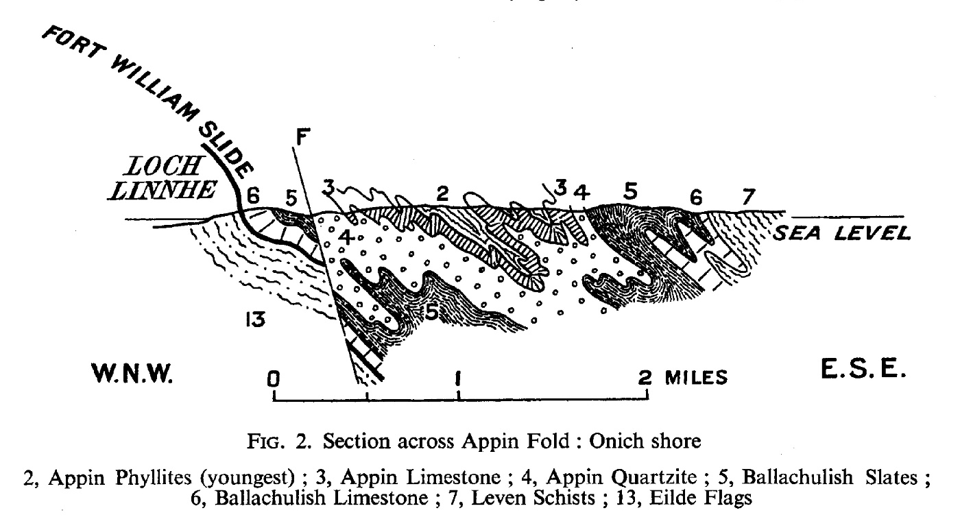
(Figure 2) Section across Appin Fold: Onich shore

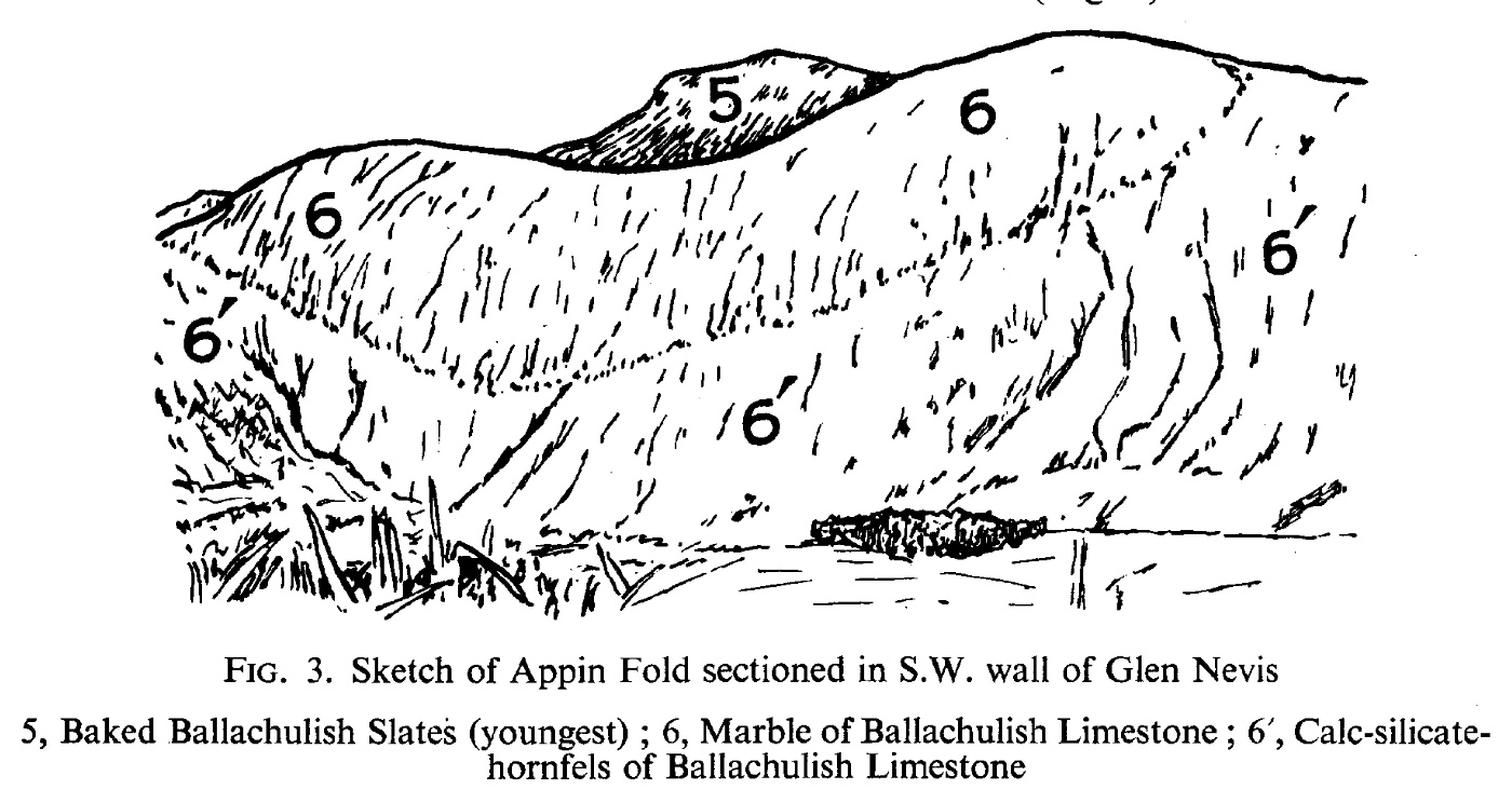
(Figure 3) Sketch of Appin Fold sectioned in S.W. wall of Glen Nevis

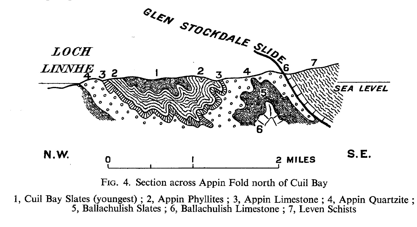
(Figure 4) Section across Appin Fold north of Cuil Bay

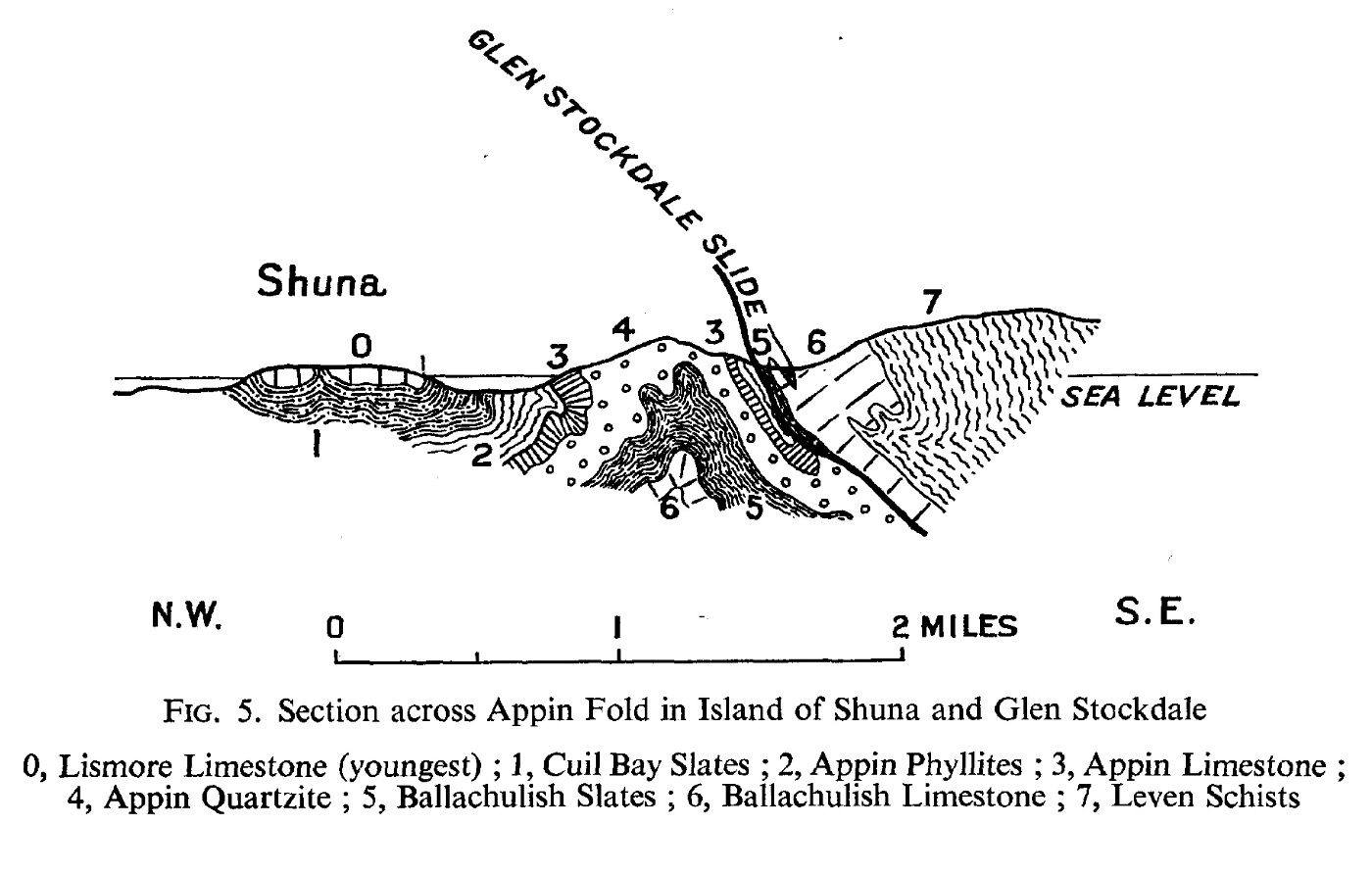
(Figure 5) Section across Appin Fold in Island of Shuna [NM 920 490] and Glen Stockdale [NM 950 490]

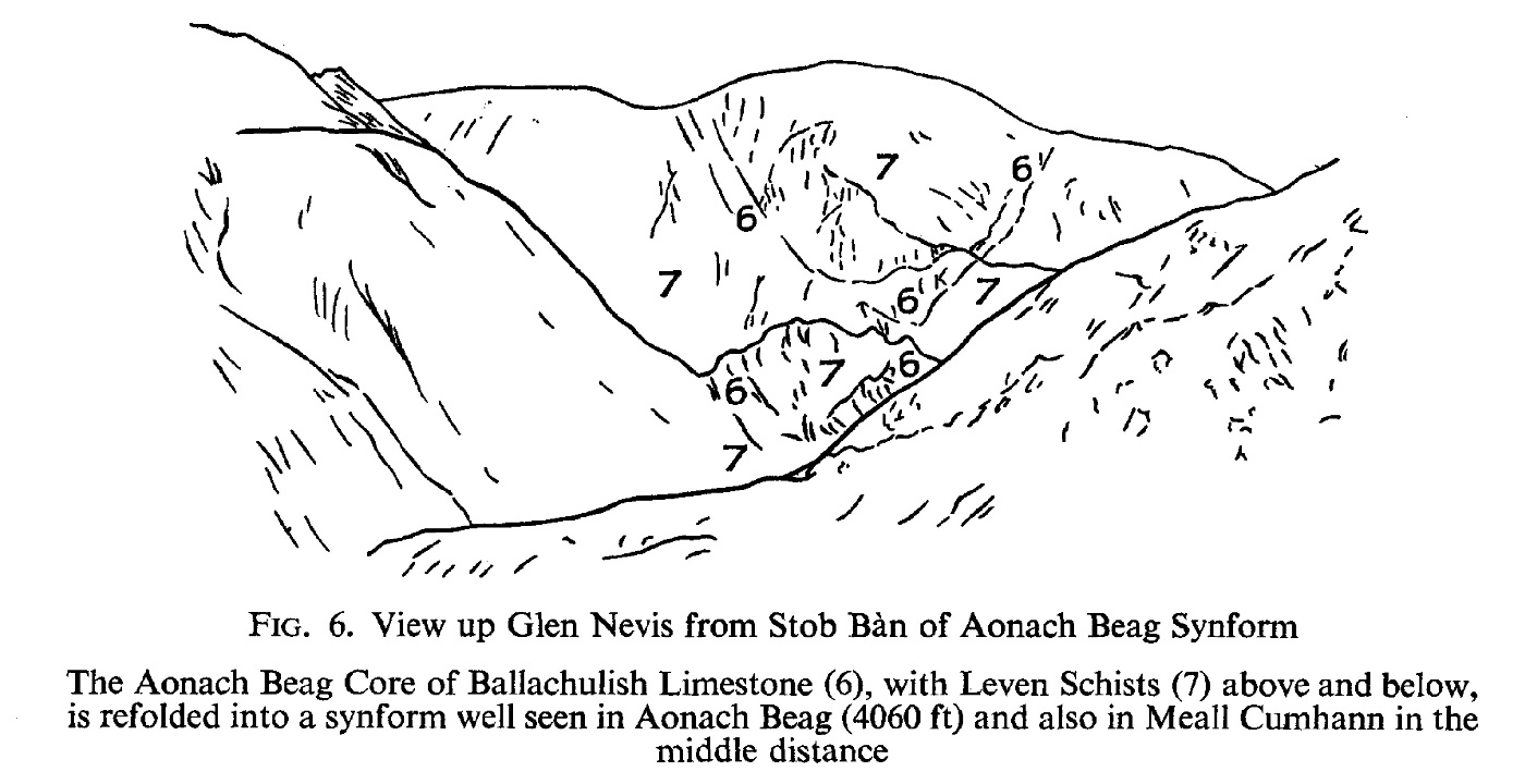
(Figure 6) View up Glen Nevis from Stob Bàn of Aonach Beag Synform

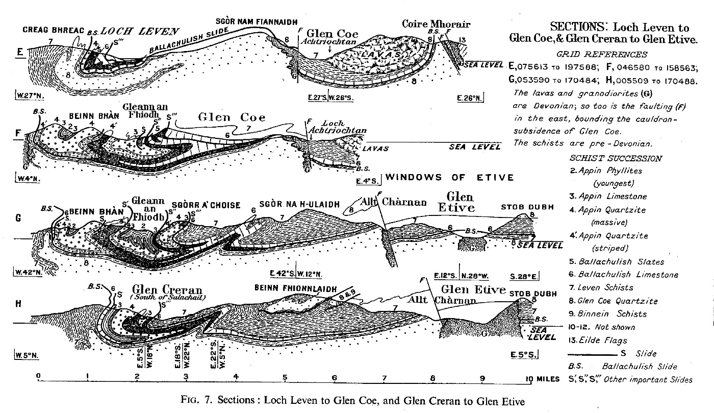
(Figure 7) Sections: Loch Leven to Glen Coe, and Glen Creran to Glen Etive

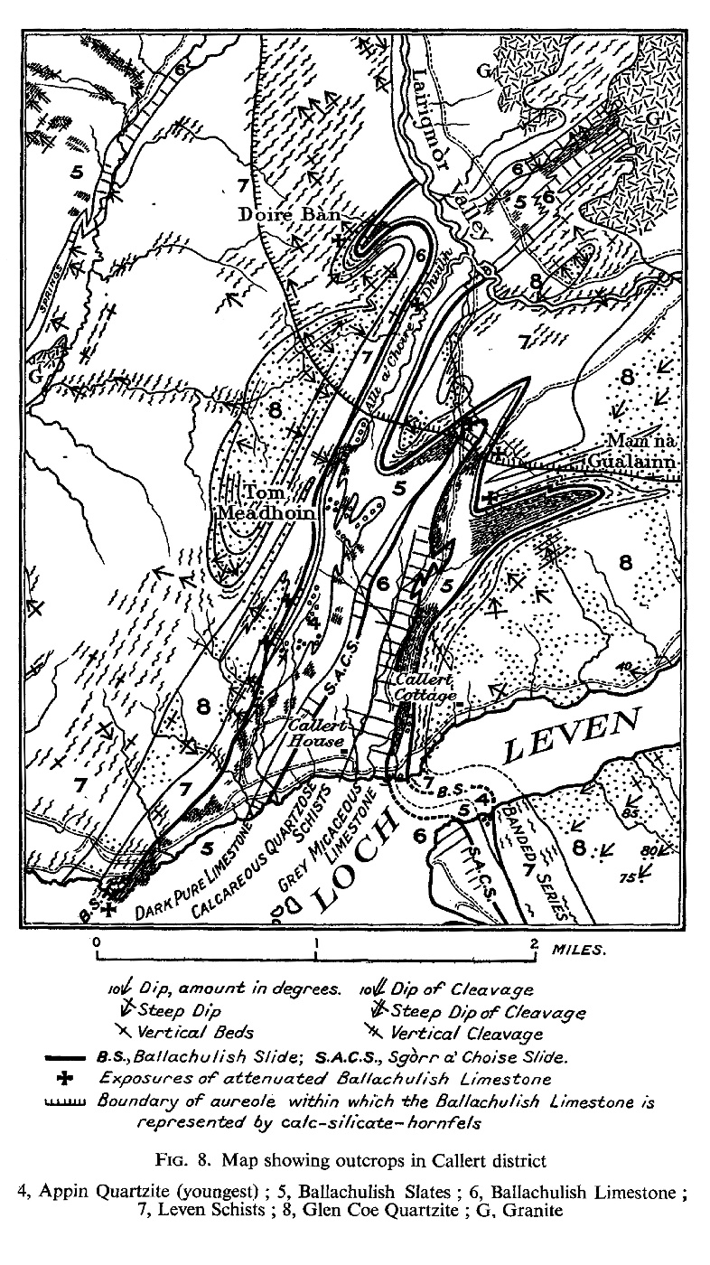
(Figure 8) Map showing outcrops in Callert district

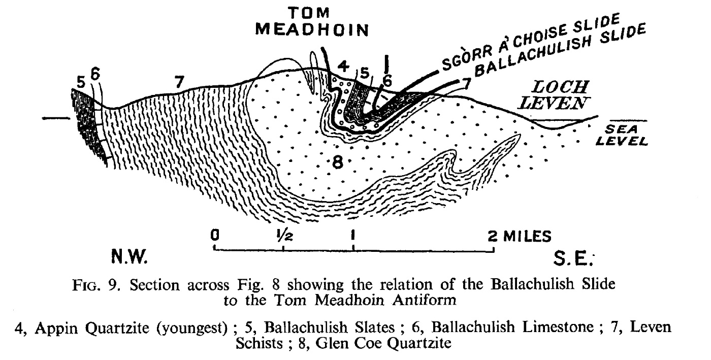
(Figure 9) Section across (Figure 8) showing relation of the Ballachulish Slide to the Tom Meadhoin [NN 085 624] Antiform

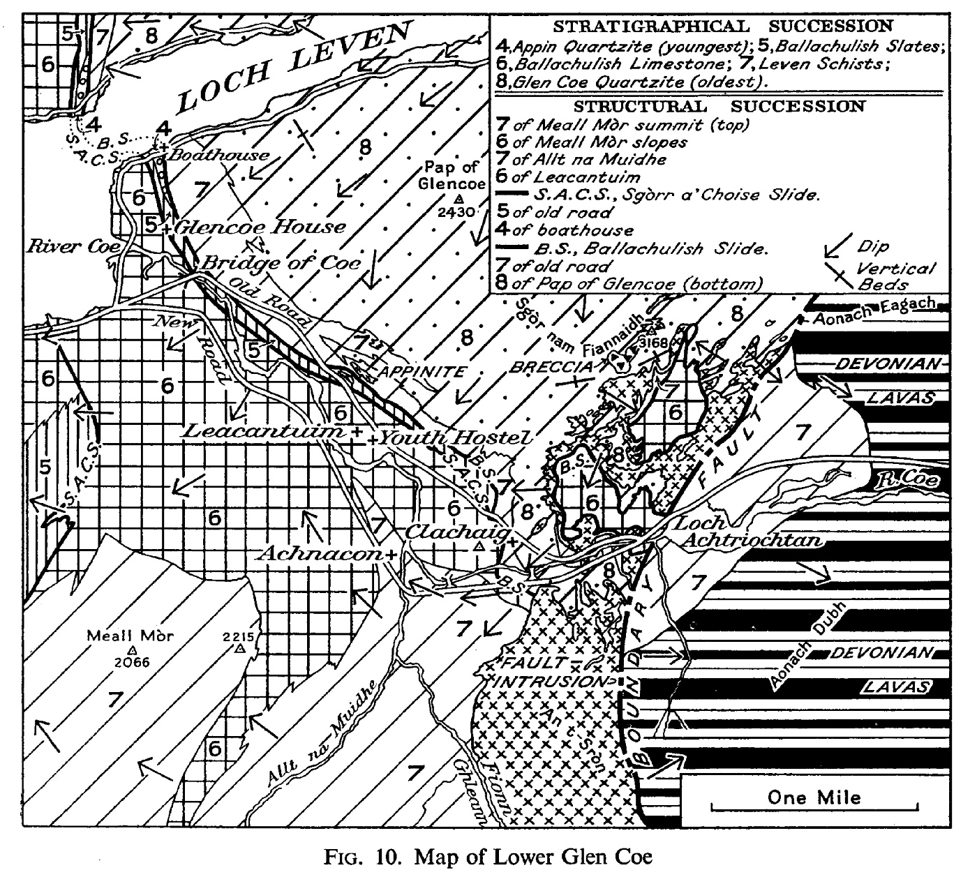
(Figure 10) Map of Lower Glen Coe

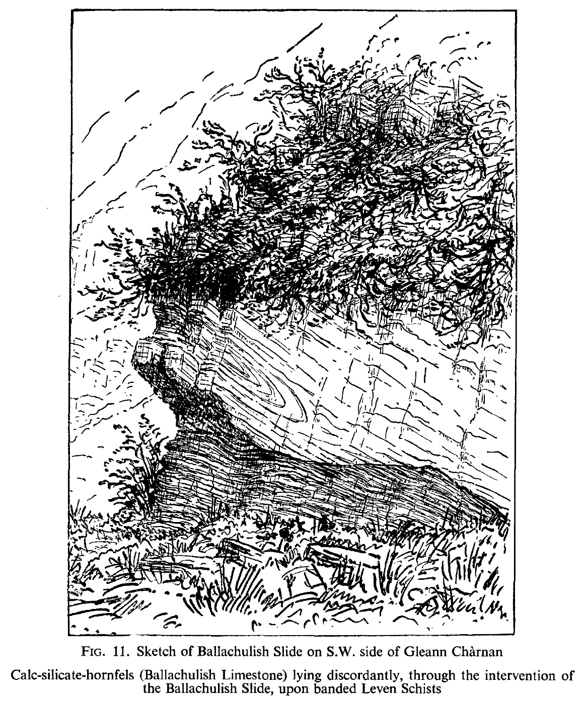
(Figure 11) Sketch of Ballachulish Slide on S.W. side of Gleann Chàrnan [NN 135 500]

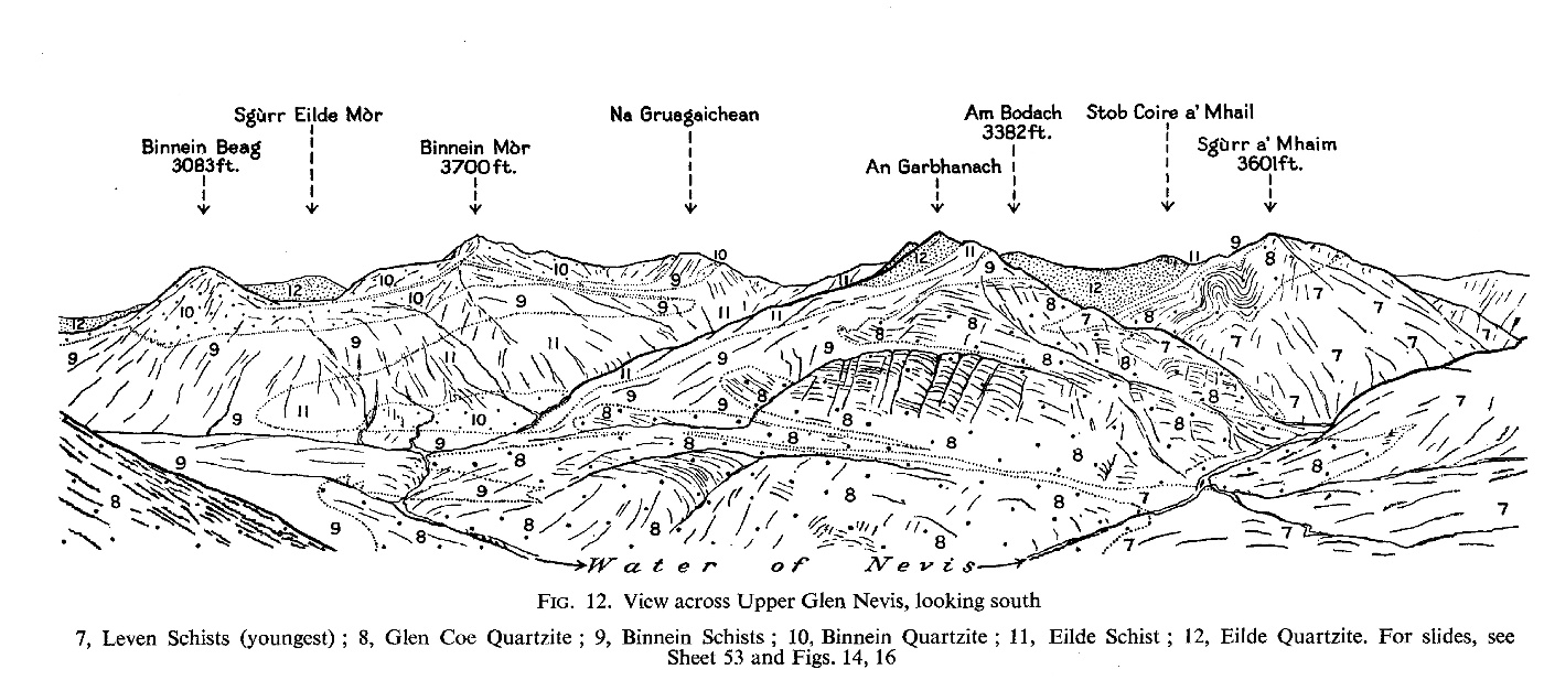
(Figure 12) View across Upper Glen Nevis, looking south

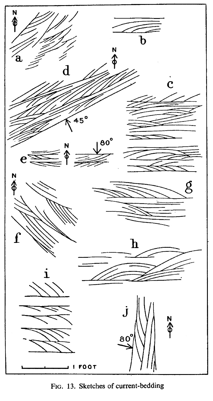
(Figure 13) Sketches of current-bedding

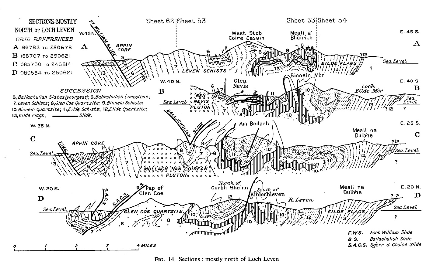
(Figure 14) Sections mostly north of Loch Leven

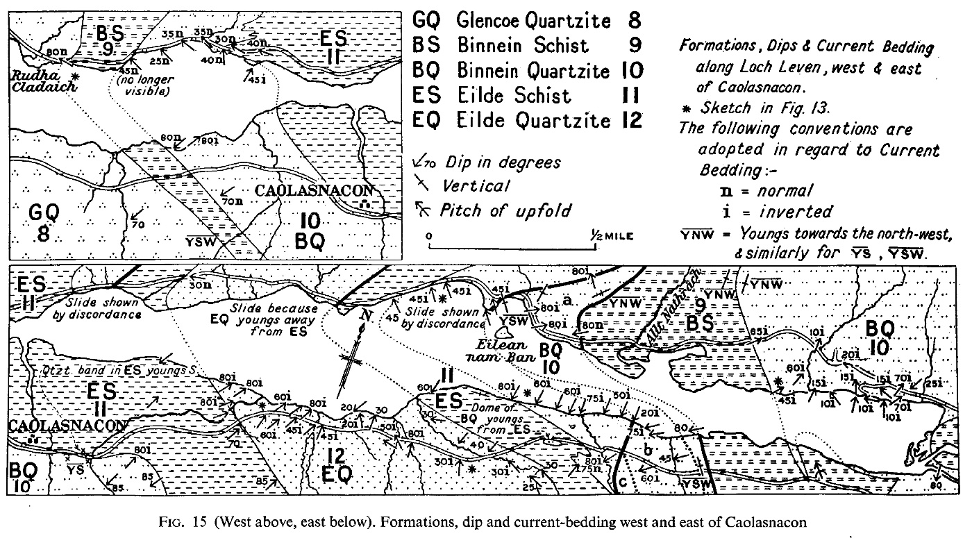
(Figure 15) Formations, dips and current-bedding west and east of Caolasnacon

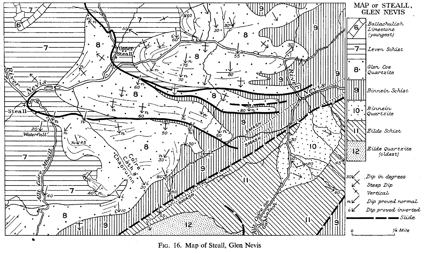
(Figure 16) Map of Steall, Glen Nevis

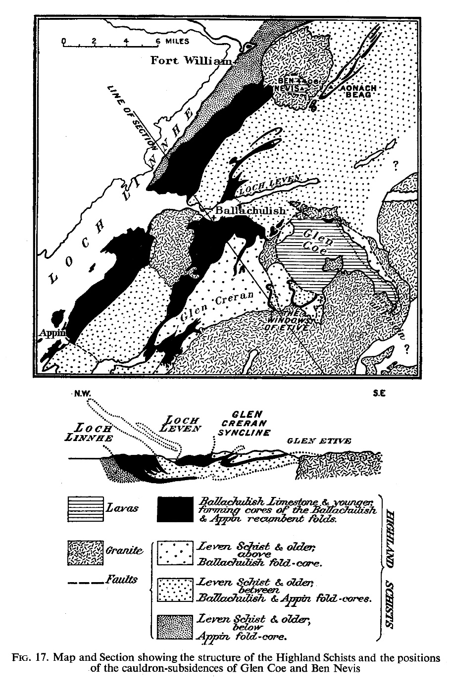
(Figure 17) Map and section showing the structure of the Highland Schists and the positions of the cauldron-subsidences of Glen Coe and Ben Nevis

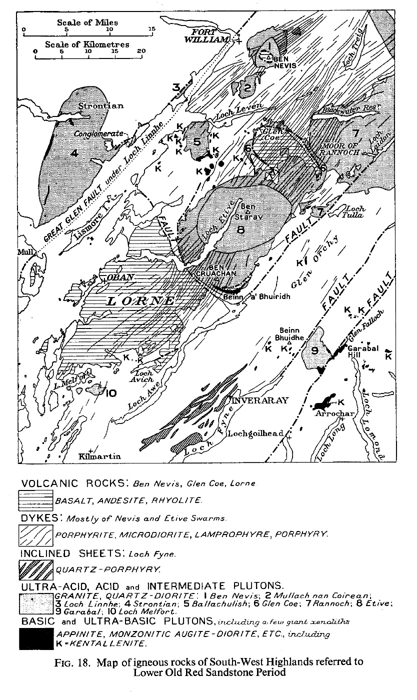
(Figure 18) Map of igneous rocks of South-West Highlands referred to the Lower Old Red Sandstone Period

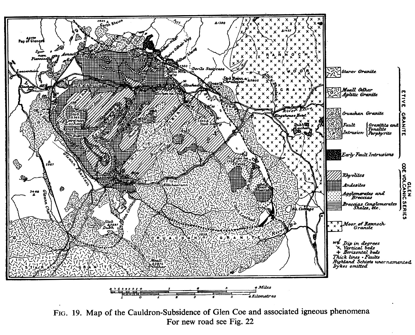
(Figure 19) Map of the Cauldron-Subsidence of Glen Coe and associated igneous phenomena

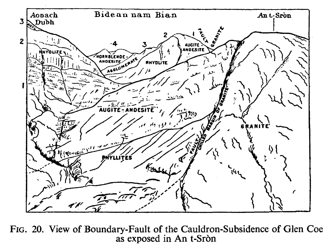
(Figure 20) View of Boundary-Fault of the Cauldron-Subsidence of Glen Coe as exposed in An t-Sròn

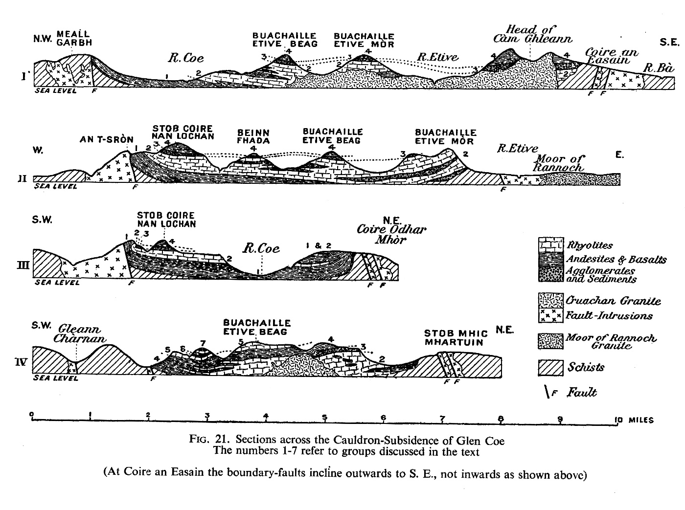
(Figure 21). Sections across the Cauldron-Subsidence of Glen Coe

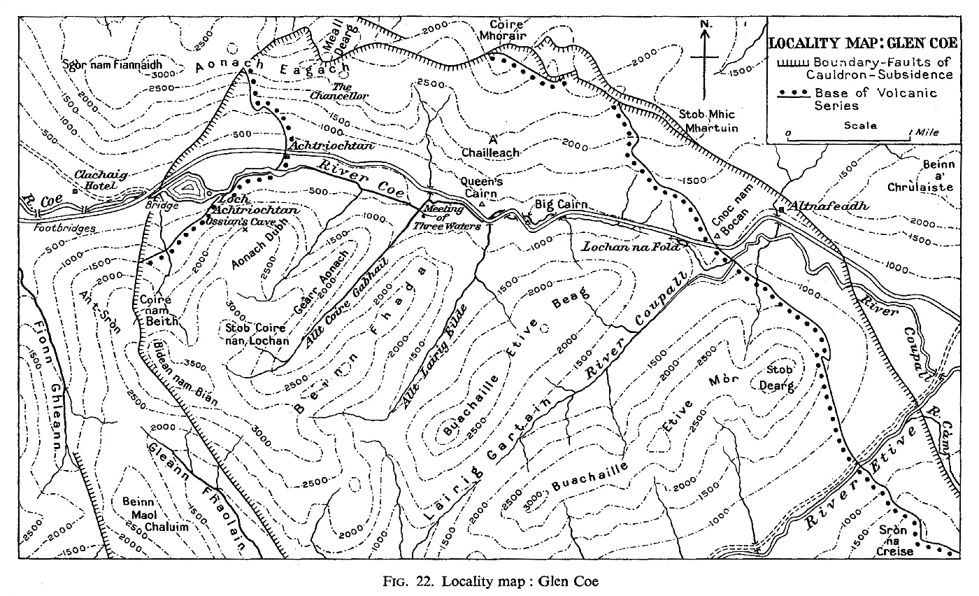
(Figure 22). Locality map: Glen Coe

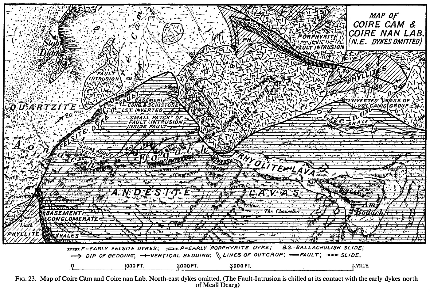
(Figure 23). Map of Coire Càm [NN 154 585] and Coire nan Lab [NN 167 584]

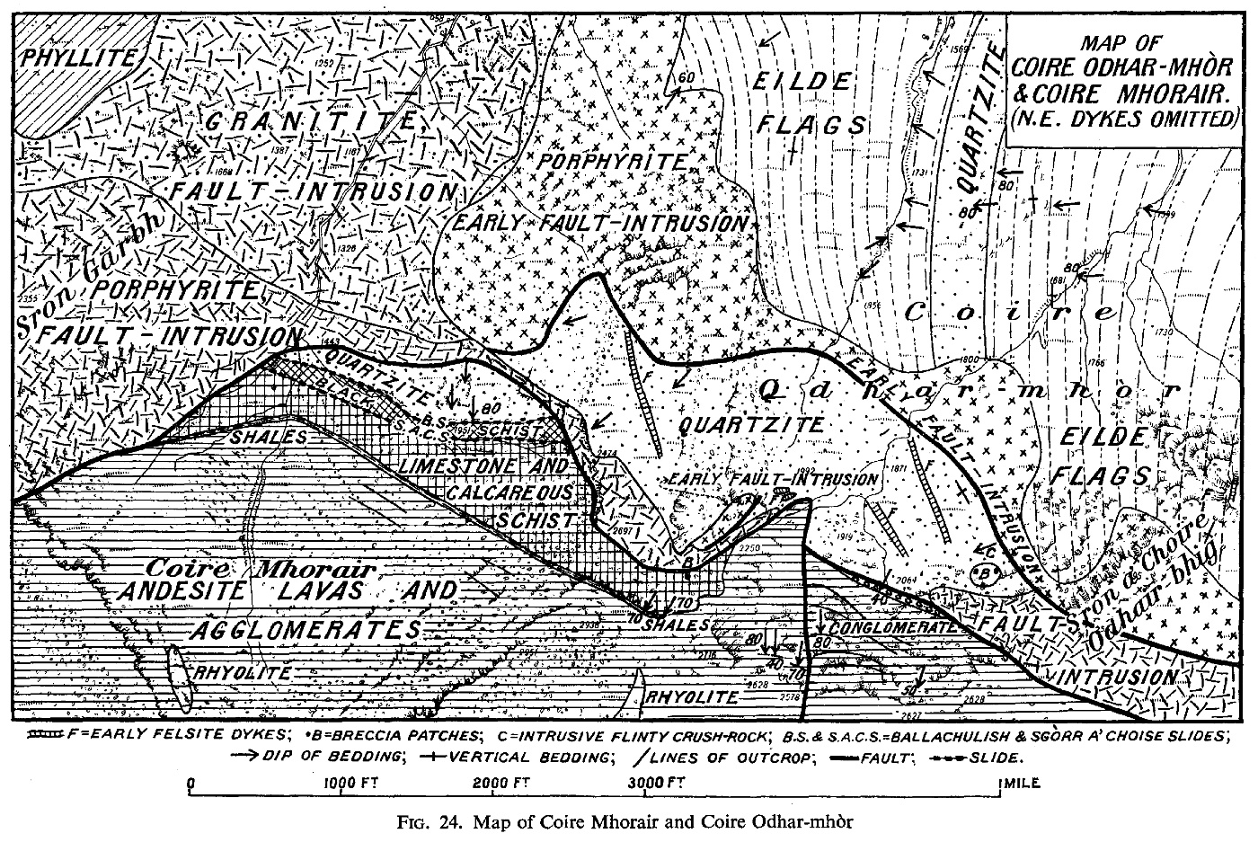
(Figure 24). Map of Coire Mhorair and Coire Odhar-mhòr [NN 196 583]

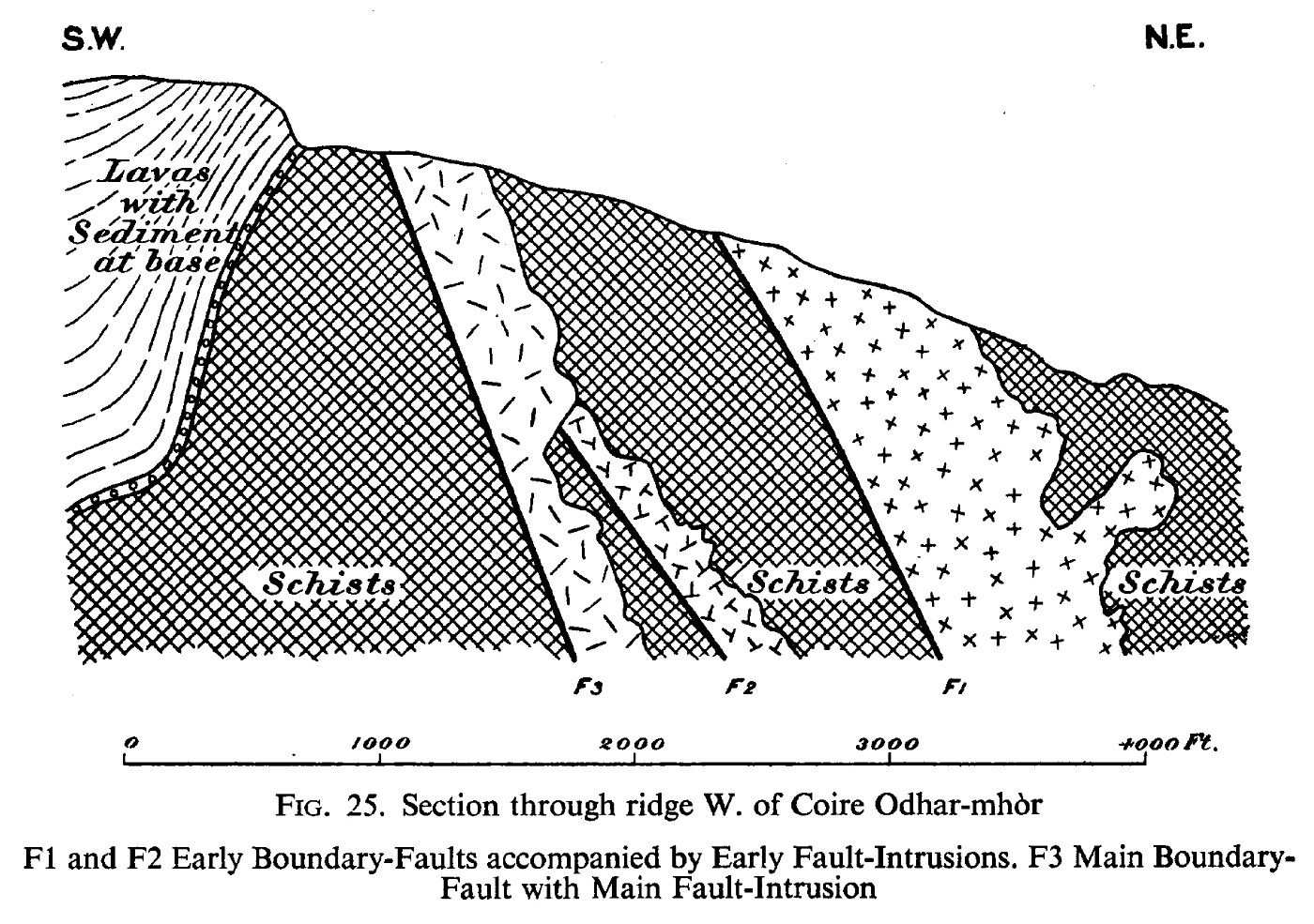
(Figure 25). Section through ridge W. of Coire Odhar- mhòr

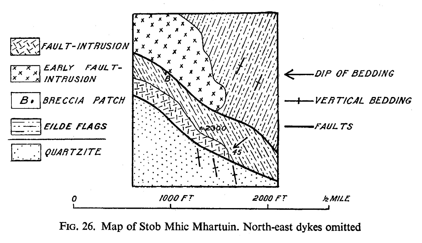
(Figure 26). Map of Stob Mhic Mhartuin [NN 207 575],.

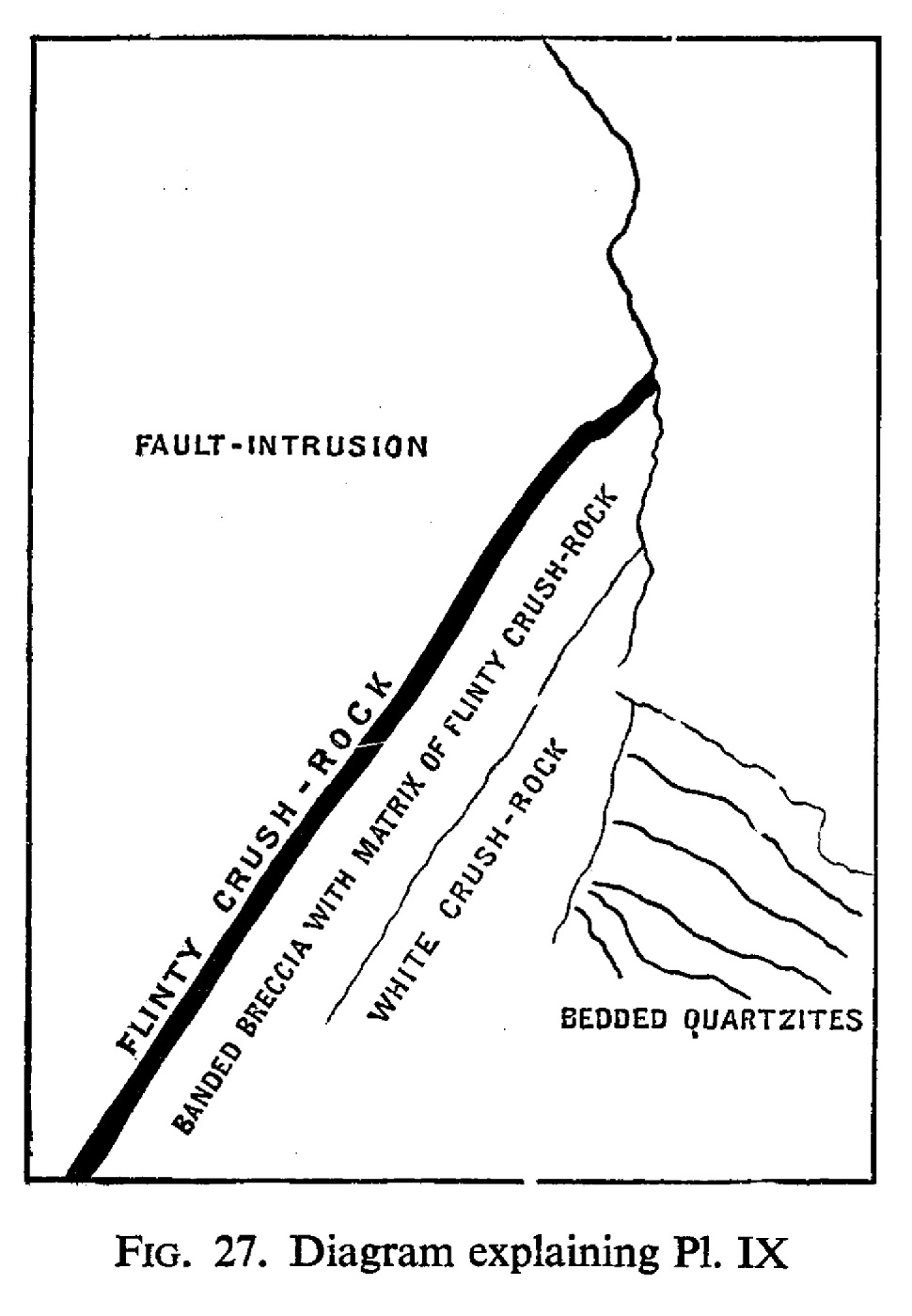
(Figure 27). Diagram of Stob Mhic Mhartuin [NN 207 575] explaining (Plate 9)

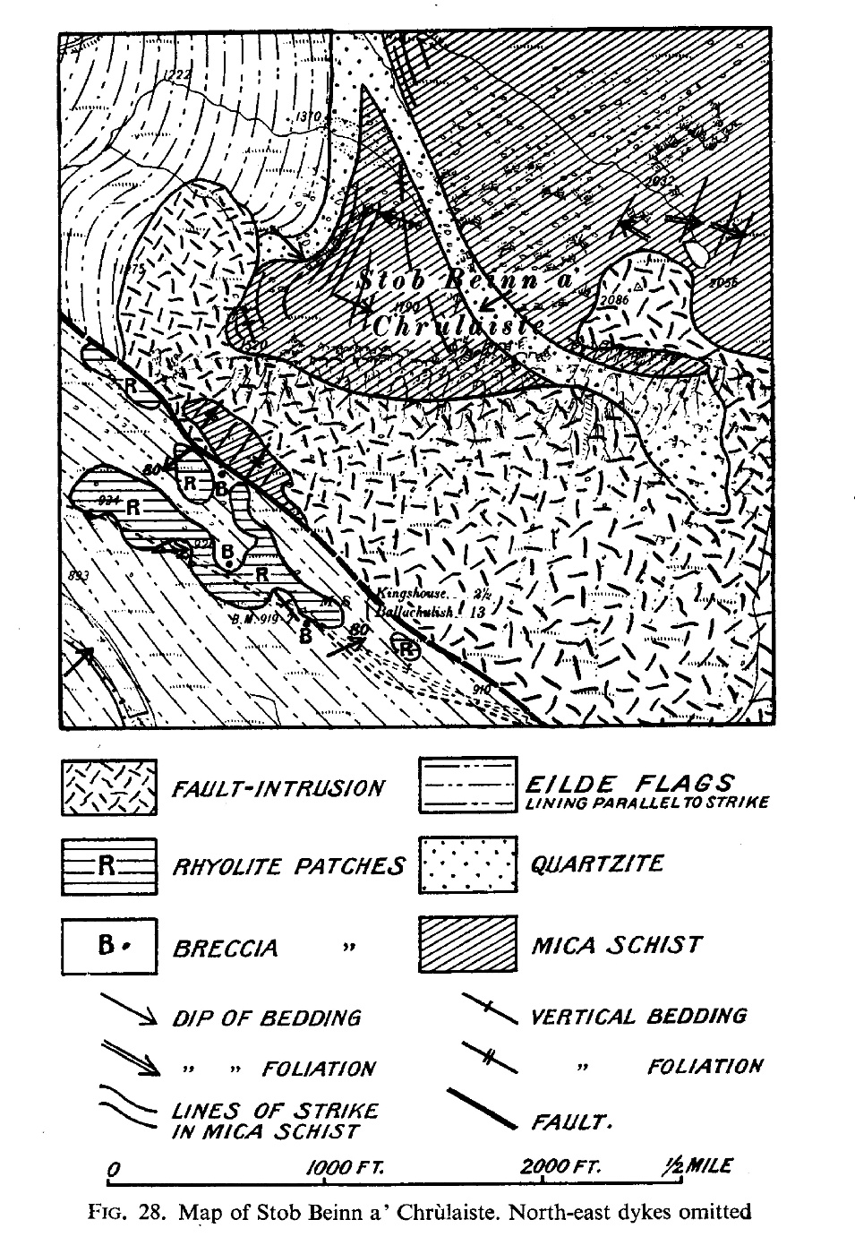
(Figure 28). Map of Stob Beinn a' Chralaiste

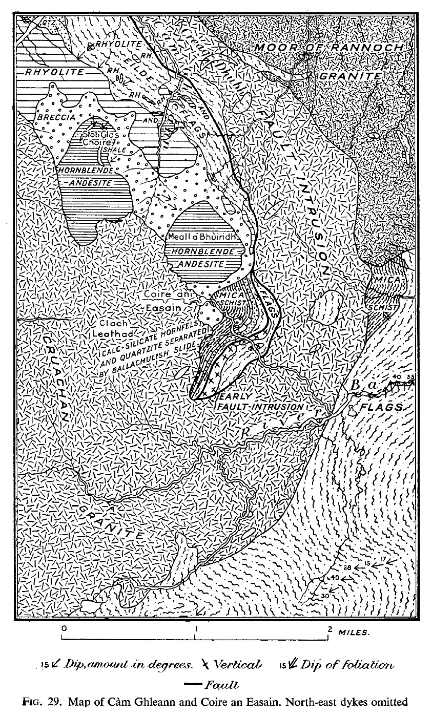
(Figure 29). Map of Càm Ghleann and Coire an Easain [NN 250 496]

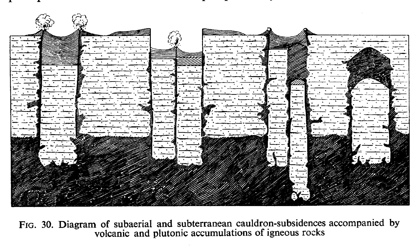
(Figure 30). Diagram of subaerial and subterranean cauldron-subsidences accompanied by volcanic and plutonic accumulations of igneous rocks

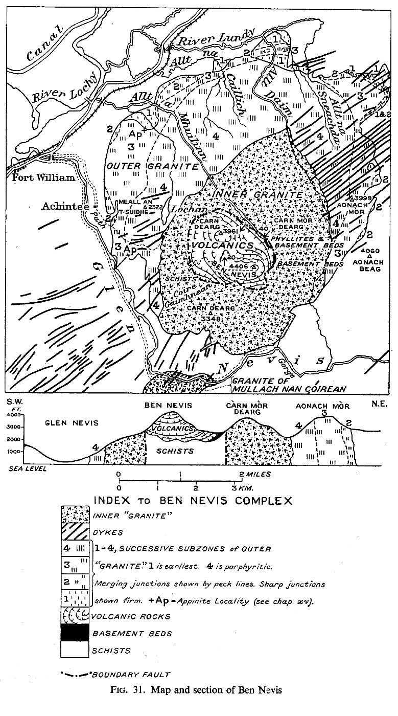
(Figure 31). Map and section of Ben Nevis

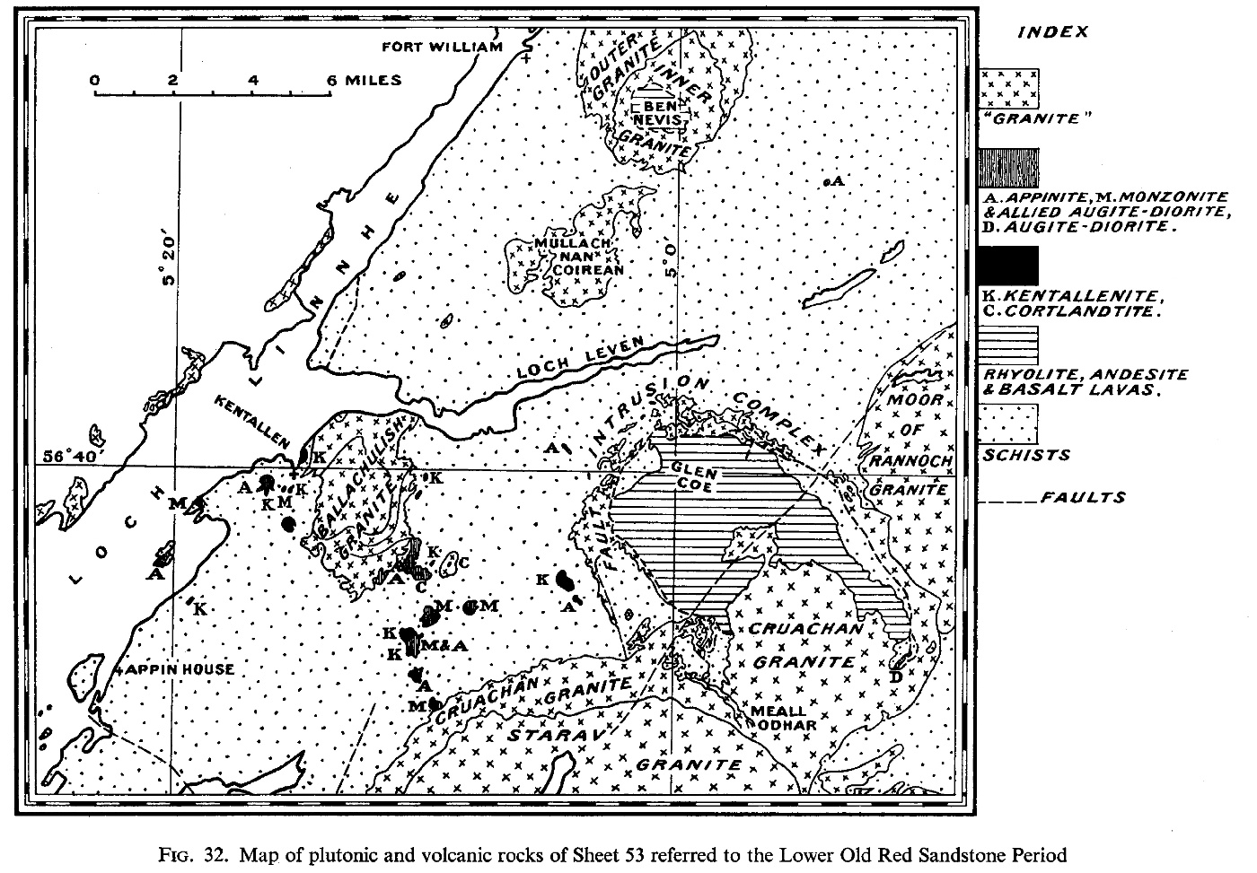
(Figure 32). Map of plutonic and volcanic rocks of Sheet 53 referred to the Lower Old Red Sandstone Period

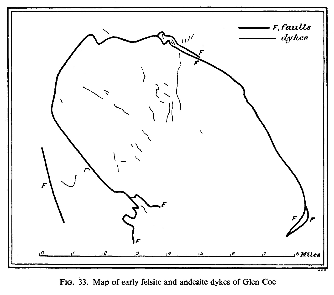
(Figure 33) Map of early felsite and andesite dykes of Glen Coe

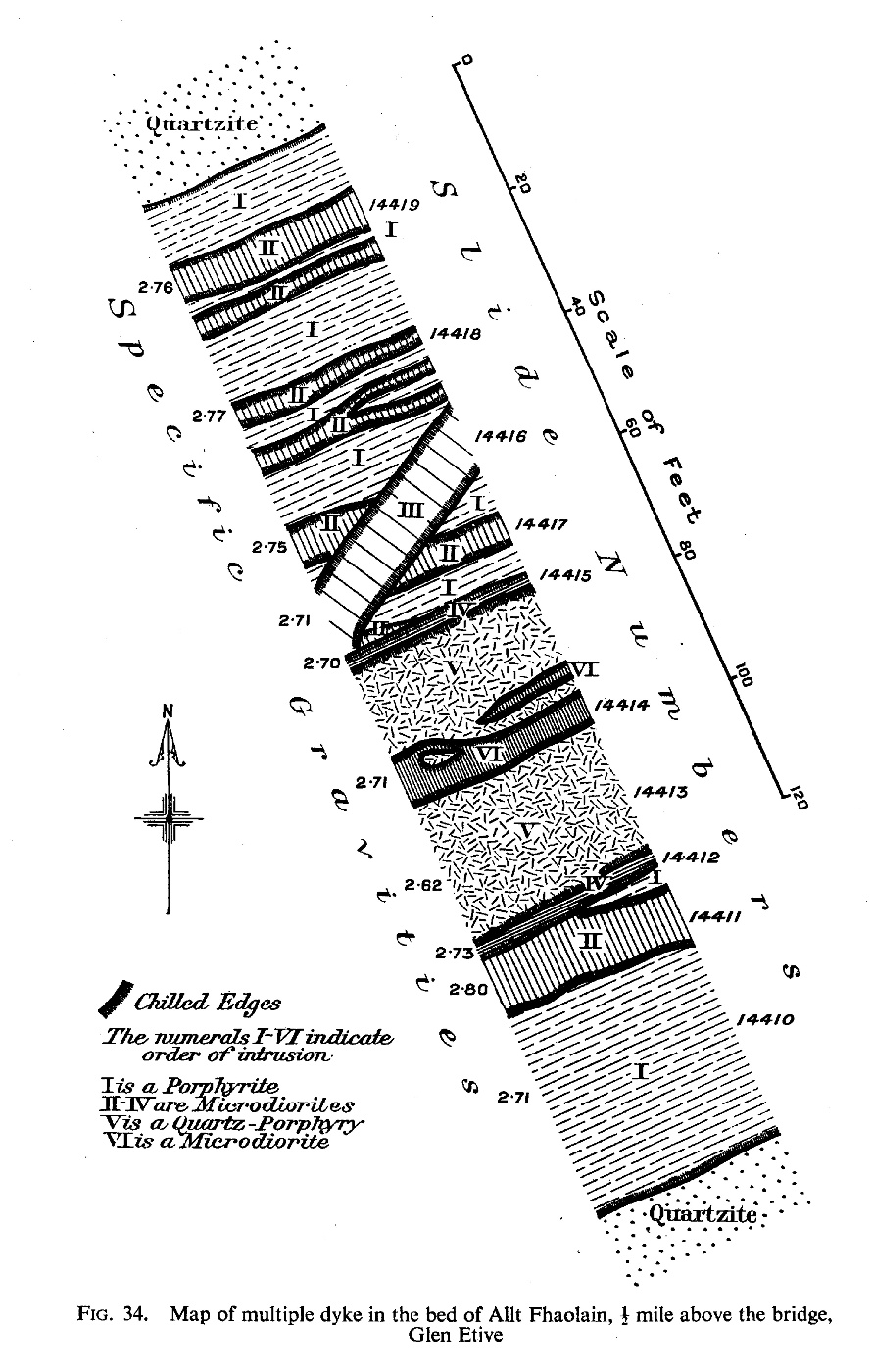
(Figure 34) Map of multiple dyke, Allt Fhaolain [NN 158 510], Glen Etive

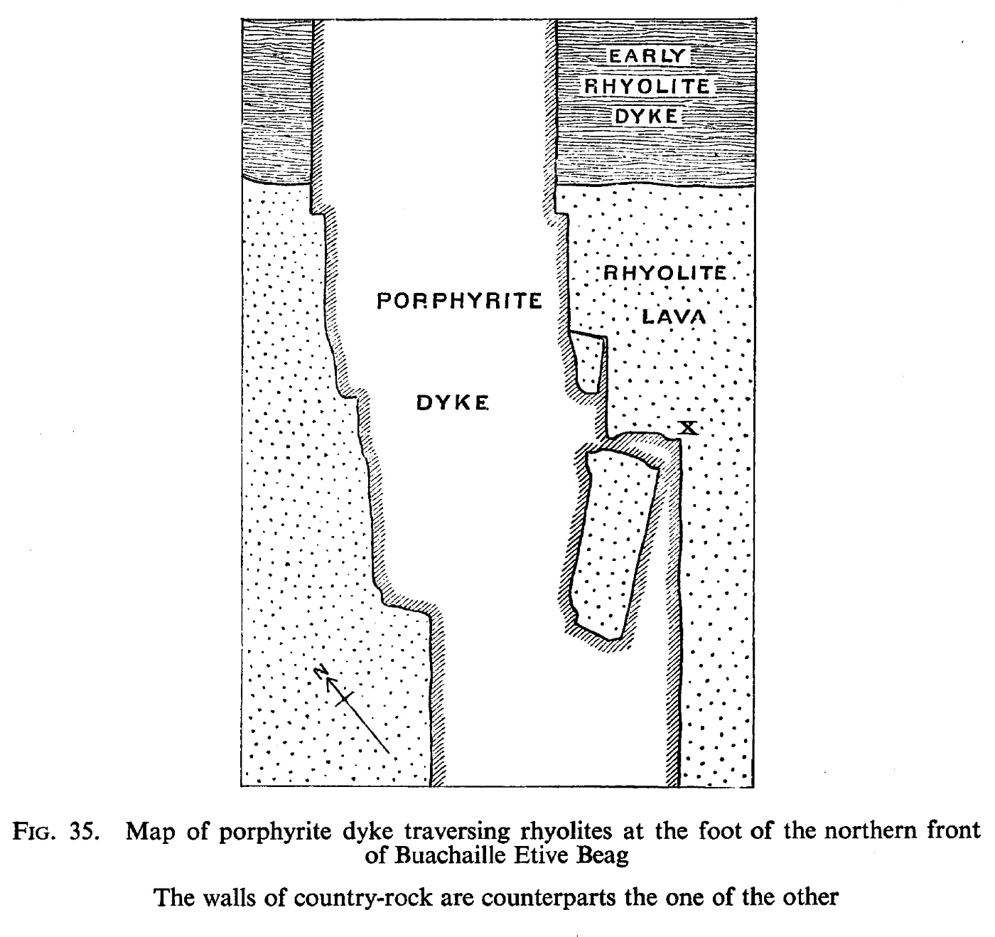
(Figure 35) Map of dyke, Buachaille Etive Beag [NN 192 548]. The walls are counterparts

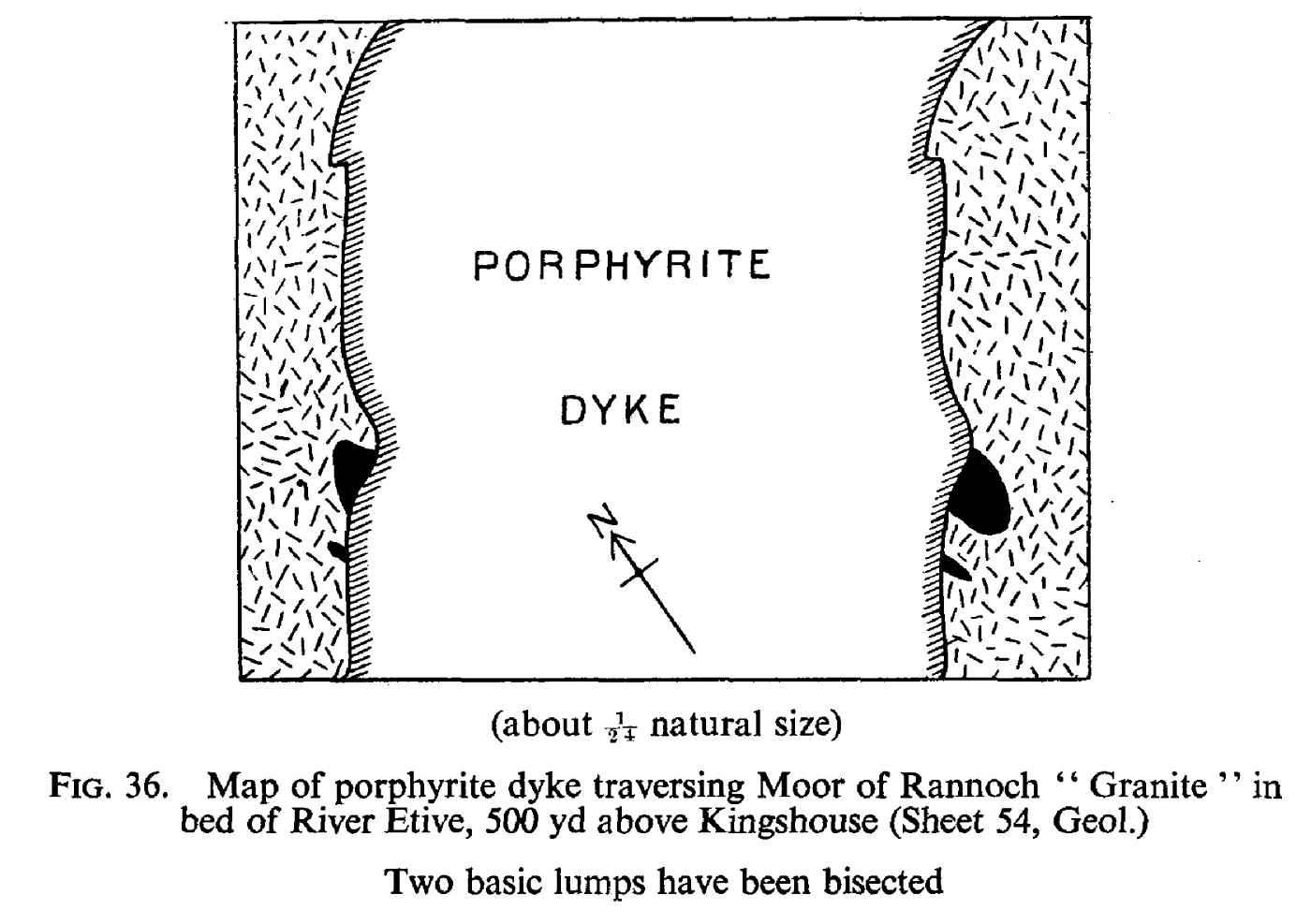
(Figure 36) Map of dyke, River Etive, bisecting two basic lumps in Moor of Rannoch "Granite"

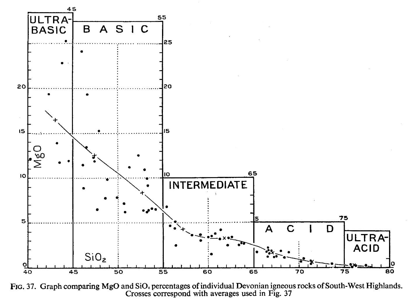
(Figure 37) Graph comparing Mg0 and SiO, percentages of individual Devonian rocks of S.W. Highlands

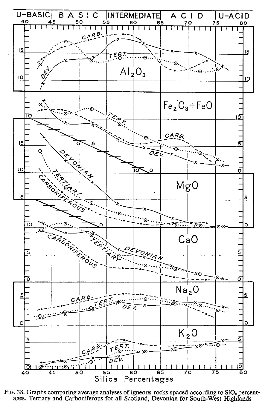
(Figure 38) Graphs comparing average analyses of Scottish Tertiary, Carboniferous and Devonian igneous rocks, the last-named restricted to S.W. Highlands

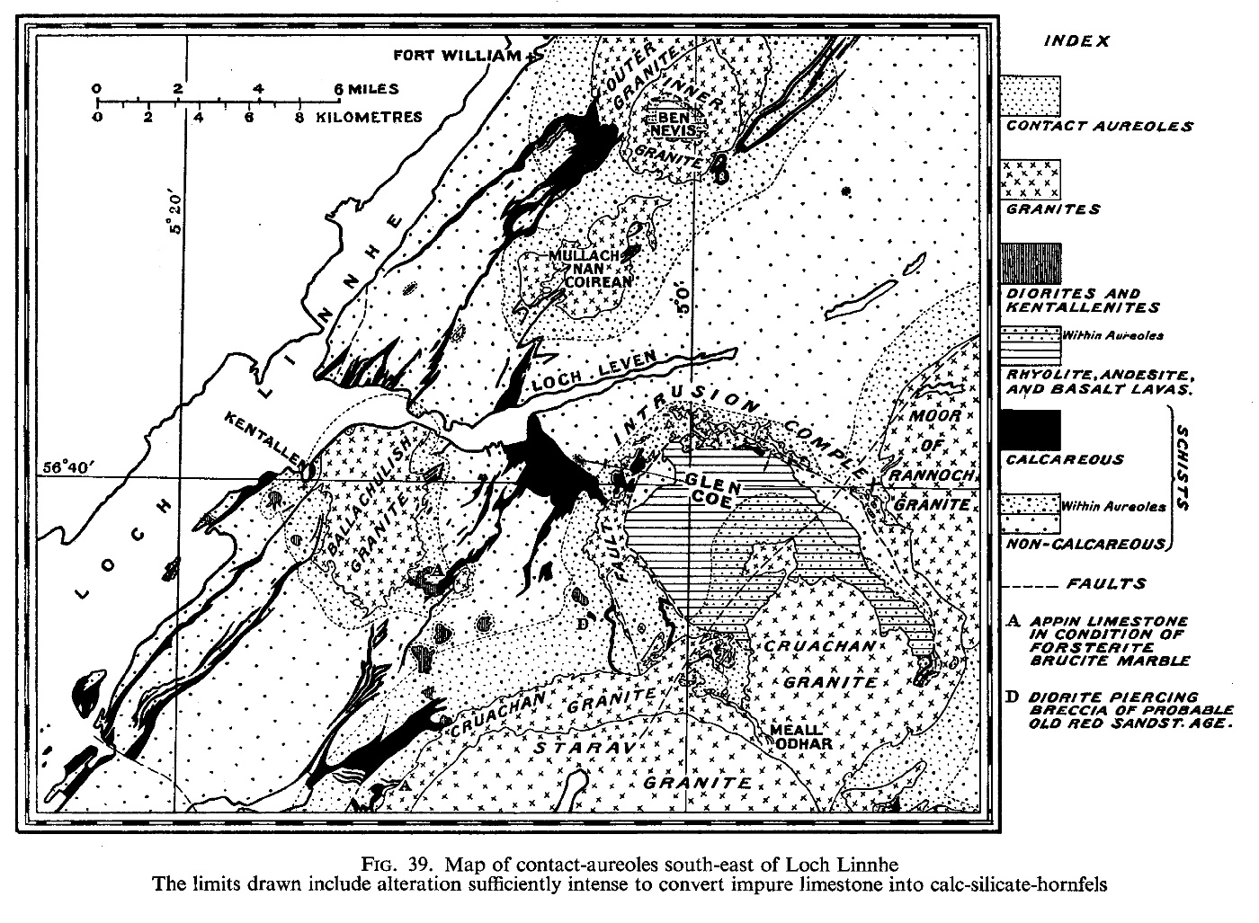
(Figure 39) Map of contact-aureoles south-east of Loch Linnhe

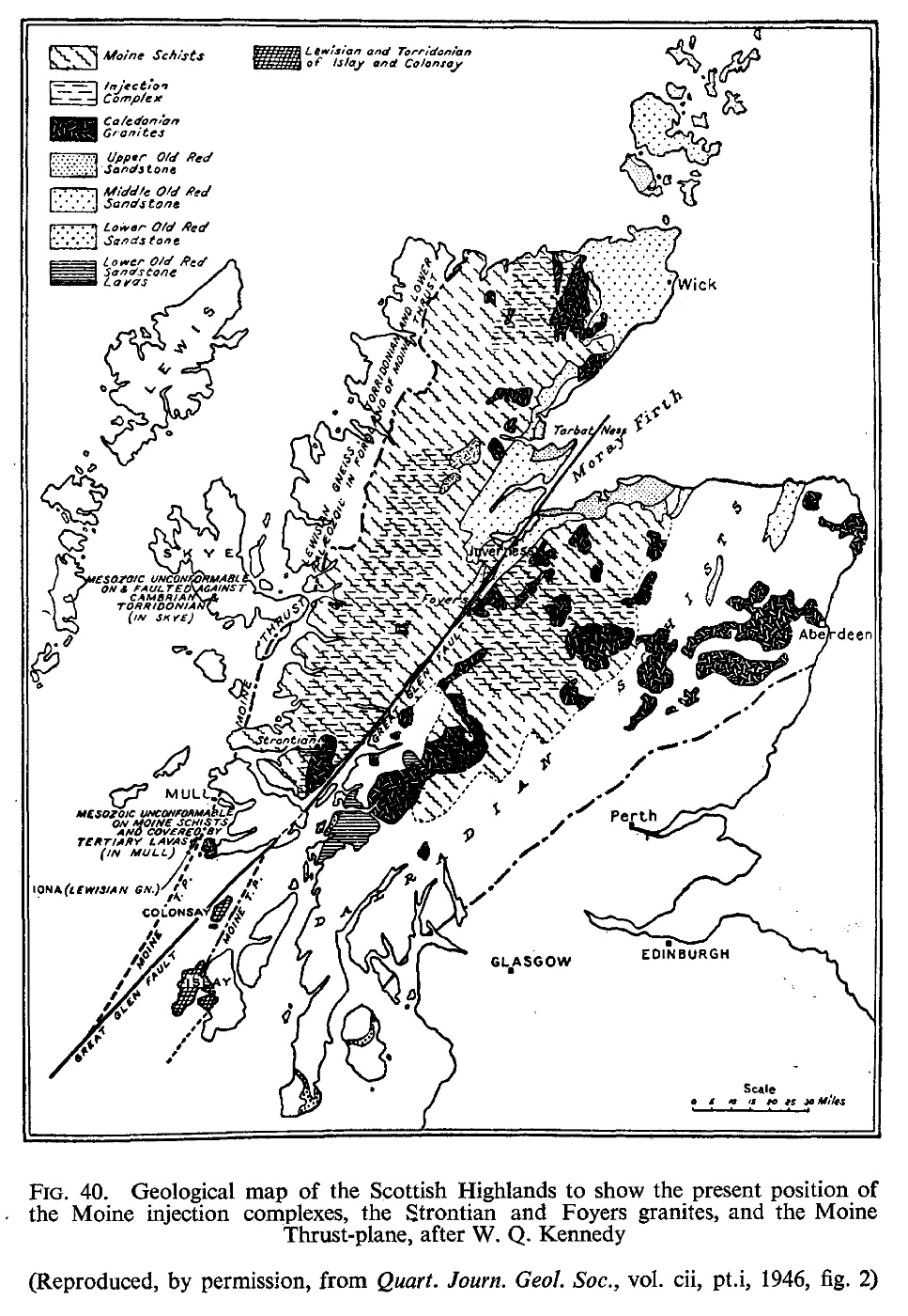
(Figure 40) Map of Great Glen Fault after Kennedy

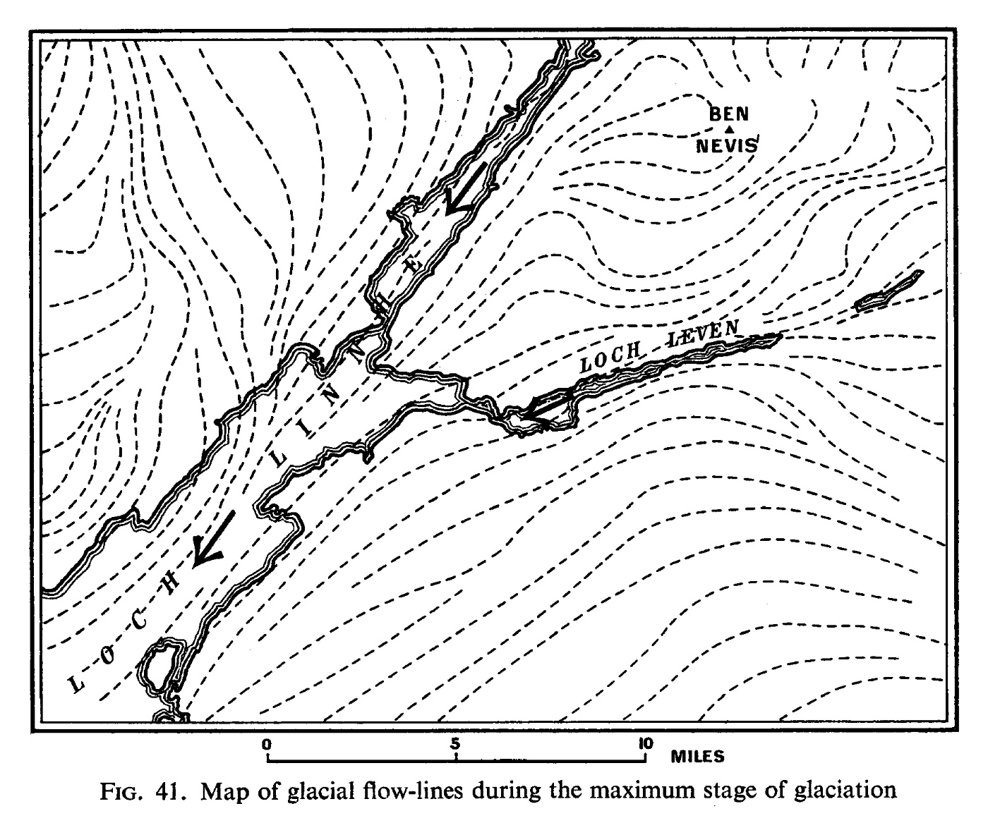
(Figure 41) Map of glacial flow-lines during the maximum stage of glaciation

Plates

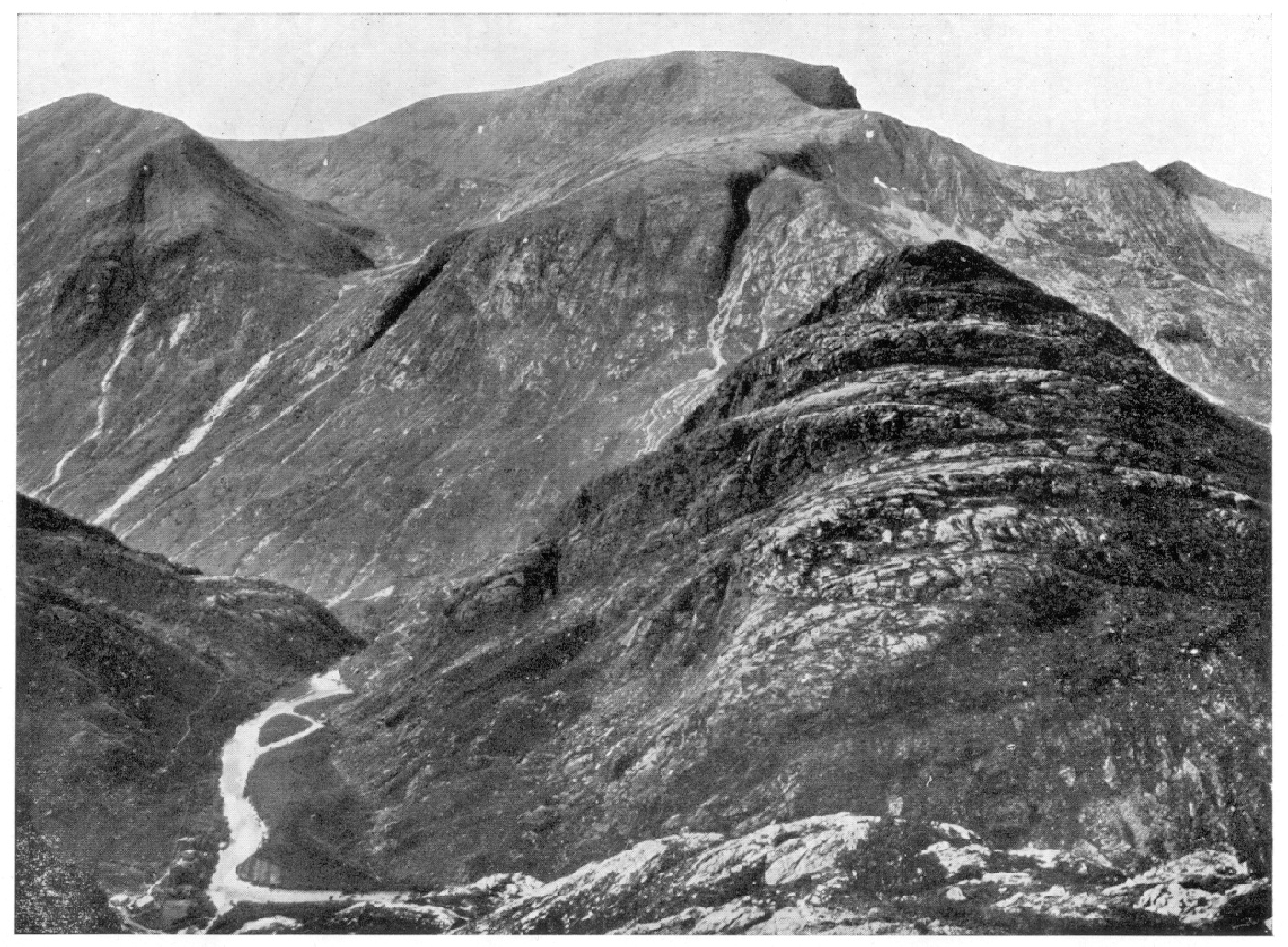
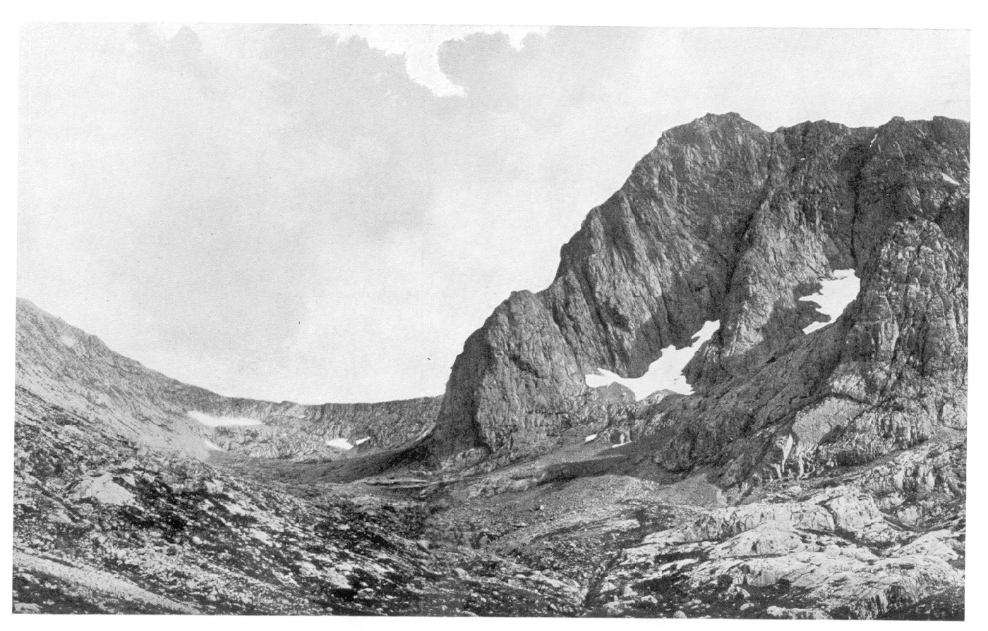
(Plate 1) Ben Nevis with hanging corrie, and River Nevis [NN 200 680] disappearing into Nevis Gorge. C.1754'

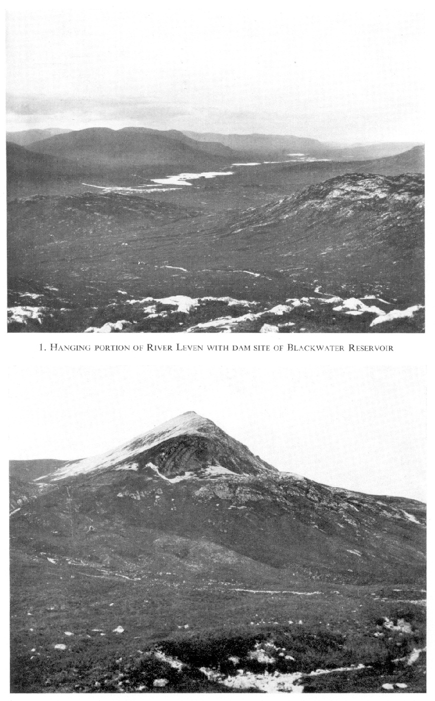
(Plate 2) (1) Hanging portion of River Leven with dam site of Blackwater Reservoir [NN 250 605]. B. (2) Stob Bàn, near watershed of Lairigmòr Valley, showing comparatively recent landslip. B.669

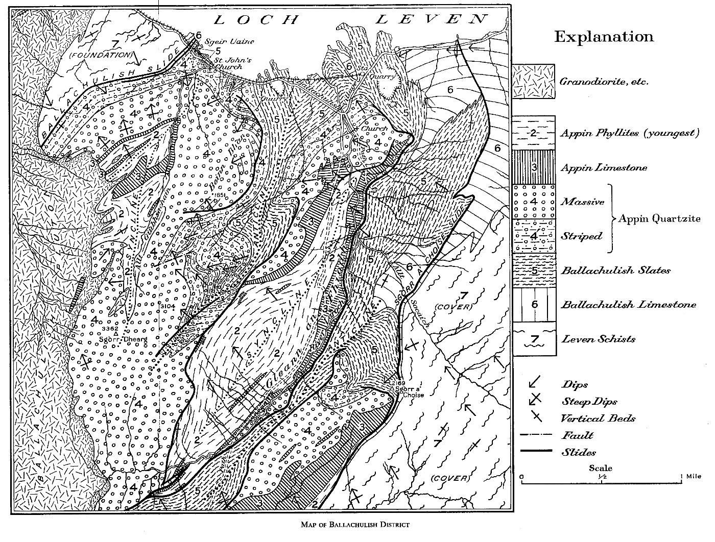
(Plate 3) Map of Ballachulish District

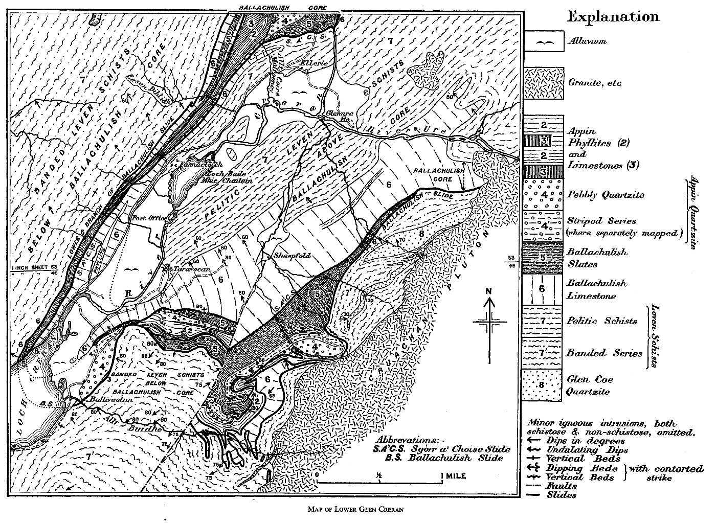
(Plate 4) Map of Lower Glen Creran

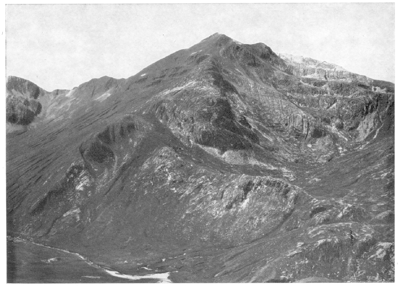
(Plate 5) Sgùrr a' Mhàim across Allt Coire Mhail. Folded Glen Coe Quartzite. C.1762.

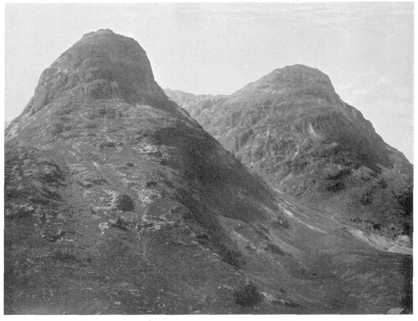
(Plate 6). Gearr Aonach [NN 160 555] and Aonach Dubh: Glen Coe "Sisters". Largely Rhyolite Lavas. B.636.

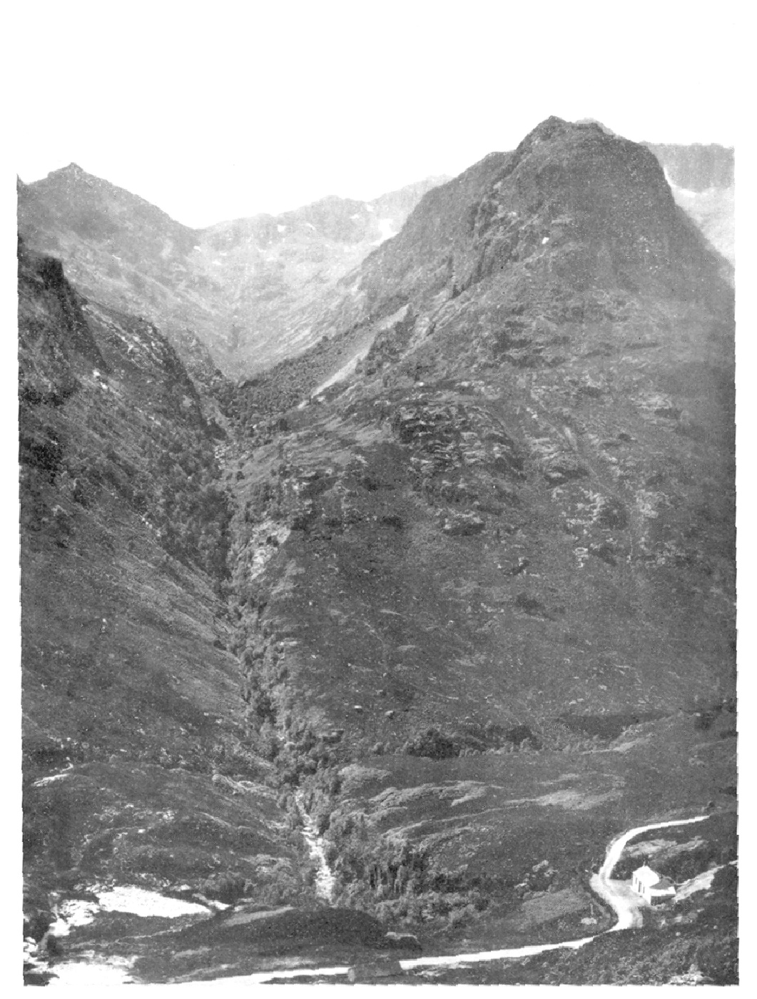
(Plate 7). Meeting of Three Waters [NN 175 563], Glen Coe; and Rock-Fall, Allt Coire Gabhail [NN 162 550]. B.

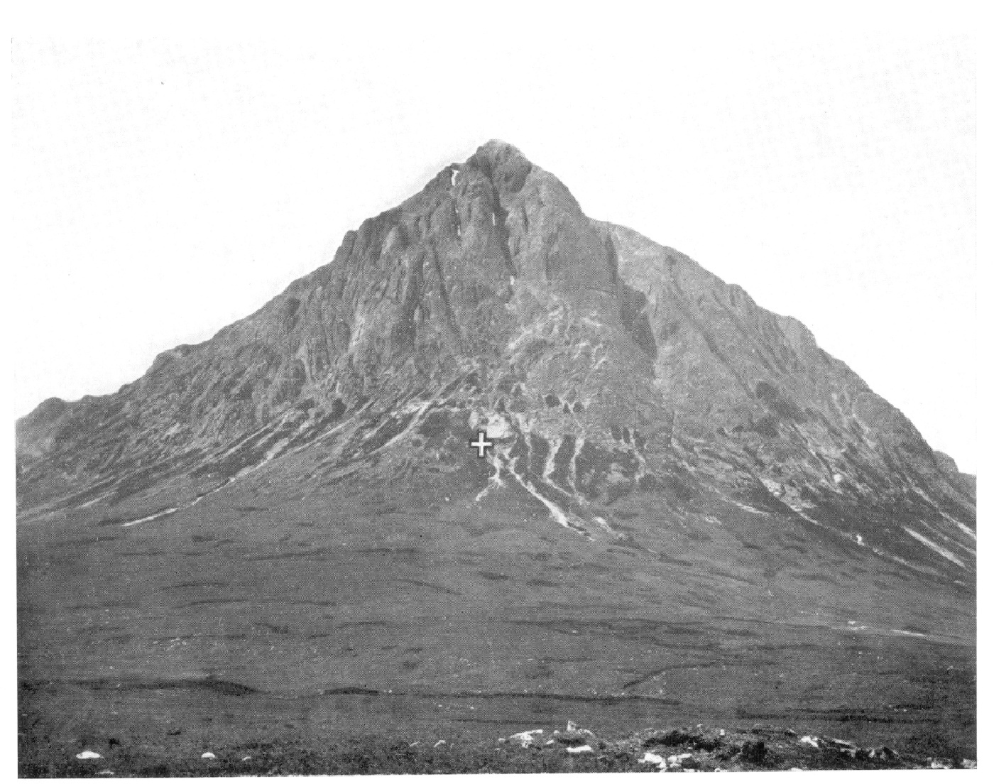
(Plate 8). Stob Dearg [NN 225 543]. Rhyolite Lavas (crags) on Schists (grass covered). B.649

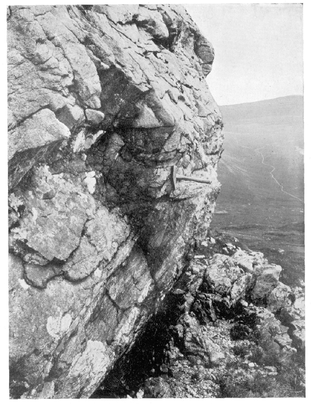
(Plate 9). Glen Coe Fault, Stob Mhic Mhartuin [NN 207 575]. C.1141

(Plate 10). Allt a 'Mhuilinn with Ben Nevis Volcanics on right, and Inner "Granite" on left, meeting in stream. C.1794–5

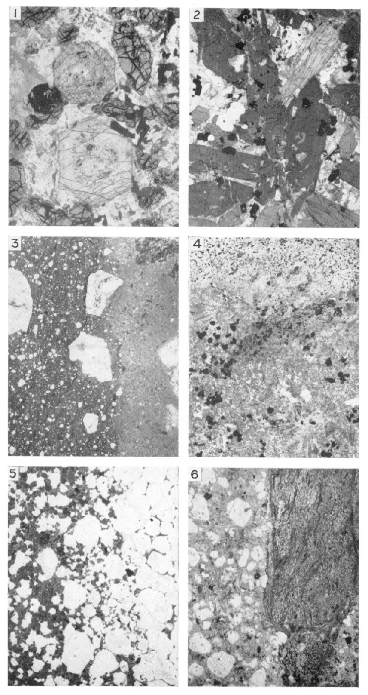
(Plate 11). Photomicrographs of Kentallenite, Appinite and rocks connected with the Fault-Intrusion of Glen Coe

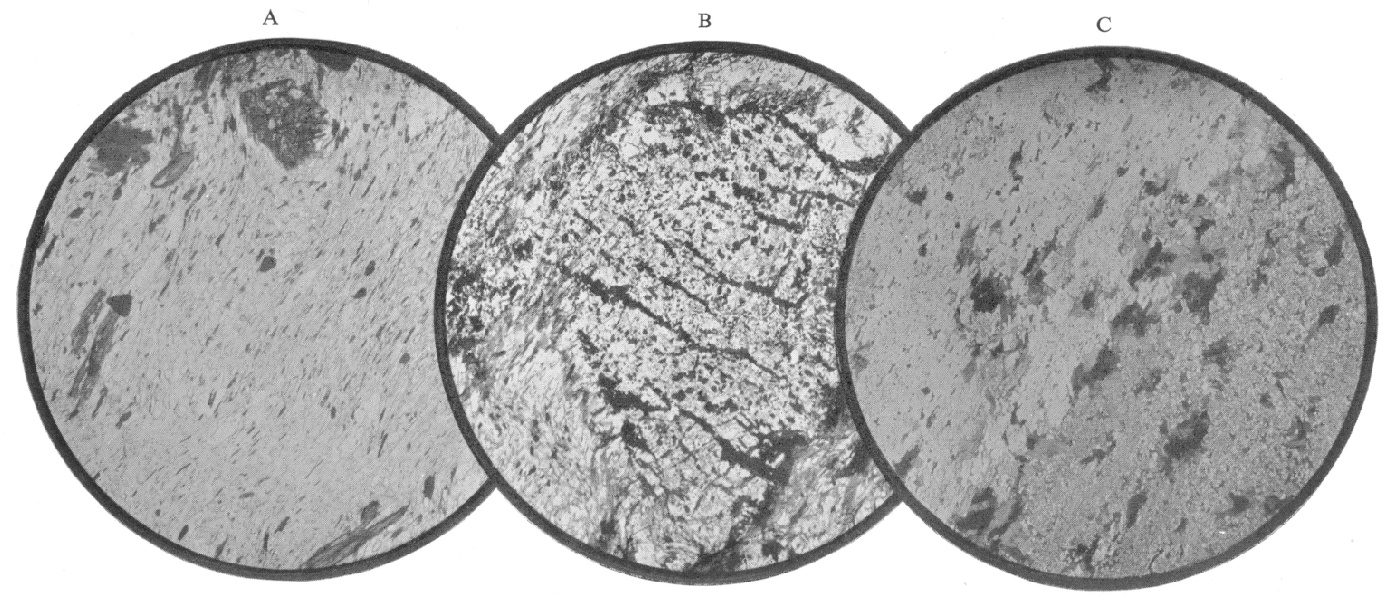
(Plate 12). Photomicrographs of Leven Schists before and after contact-alteration

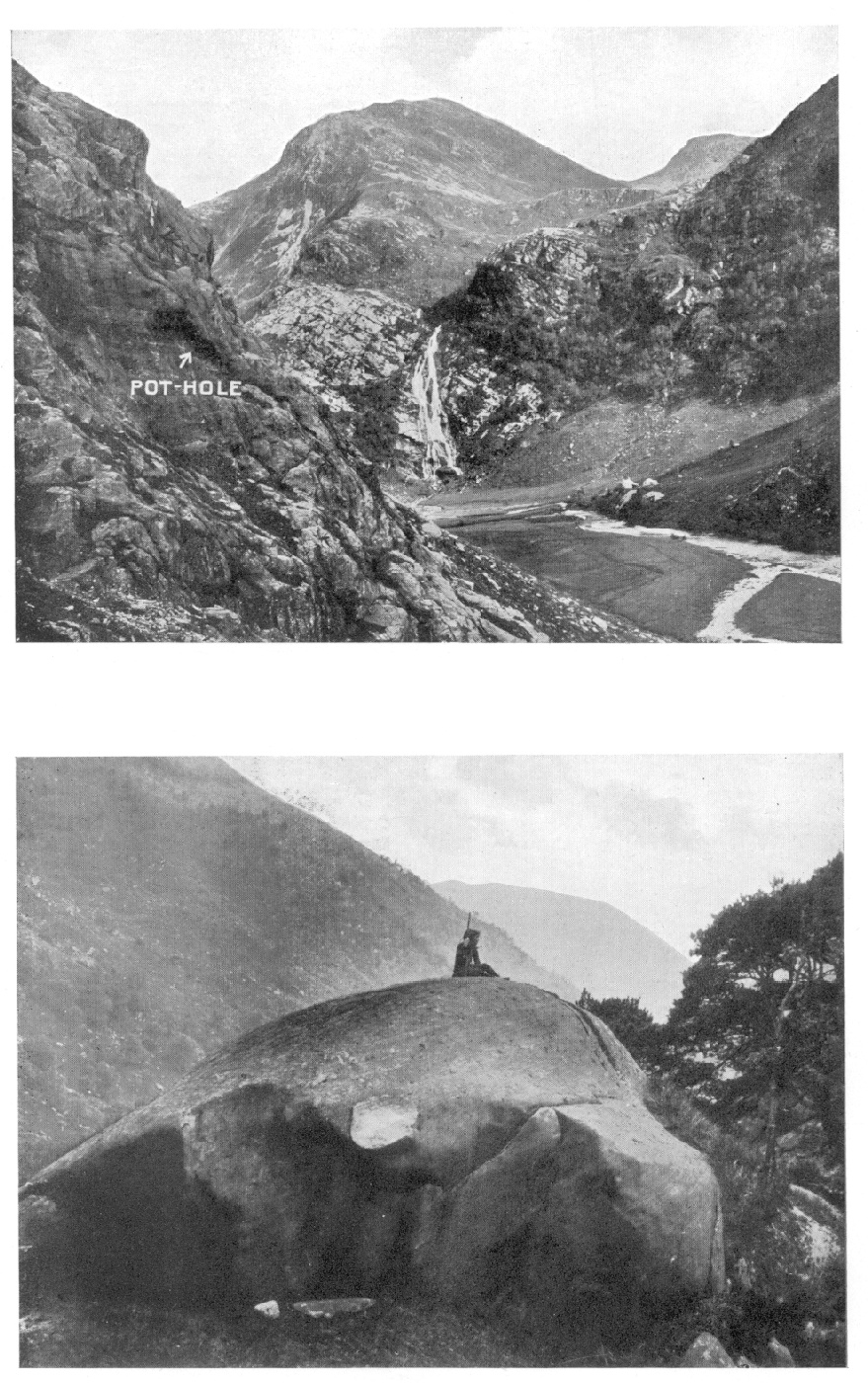
(Plate 13). (1) An Steall [NN 180 683], the waterfall of a valley hanging to Glen Nevis. C.1745. (2) Roche Moutonnee, Glen Nevis, by roadside above Polldubh [NN 141 686]. C.1737

* Reference number of photograph in the Geological Survey Scottish collection.
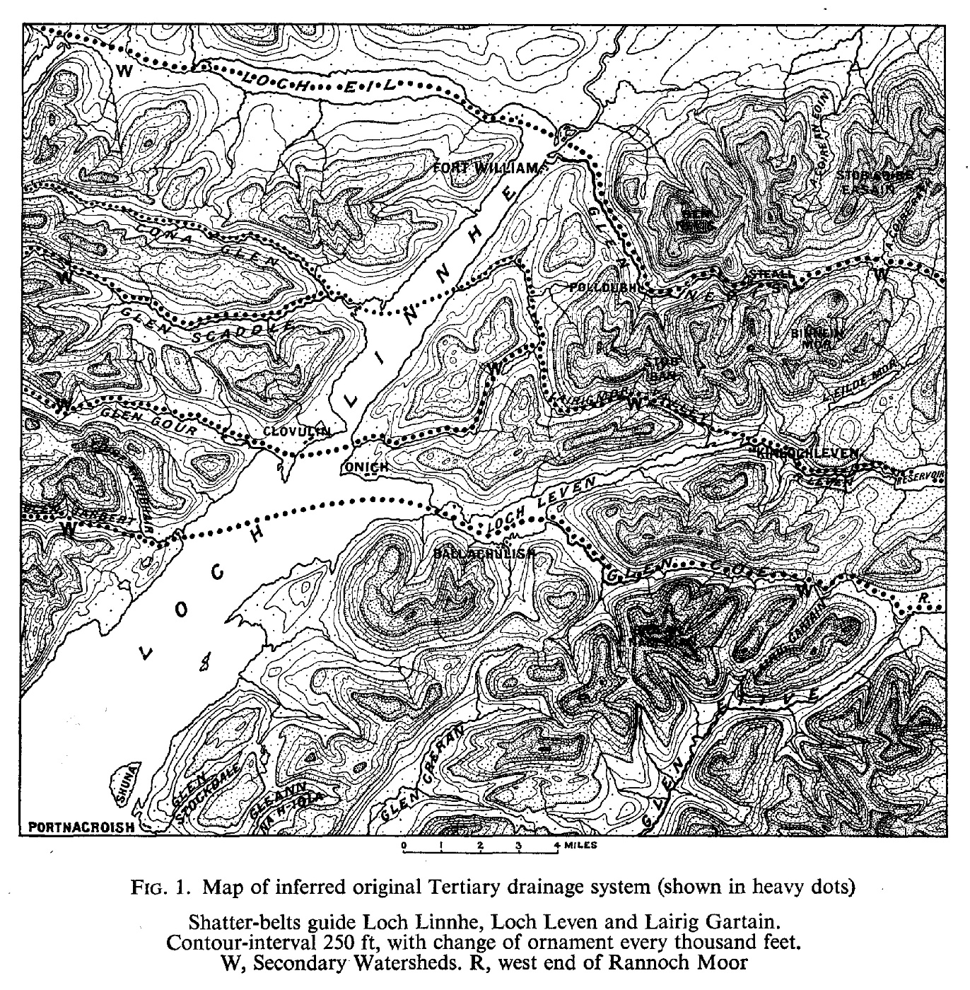
(Figure 1) Map of inferred original Tertiary drainage system (shown in heavy dots) Shatter-belts guide Loch Linnhe, Loch Leven and Lairig Gartain [NN 200 544]. Contour-interval 250 ft, with change of ornament every thousand feet. W, Secondary Watersheds. R, west end of Rannoch Moor.

(Figure 2) Section across Appin Fold: Onich shore. 2, Appin Phyllites (youngest); 3, Appin Limestone; 4, Appin Quartzite; 5, Ballachulish Slates; 6, Ballachulish Limestone; 7, Leven Schists; 13 Eilde Flags.

(Figure 3) Sketch of Appin Fold sectioned in S.W. wall of Glen Nevis 5, Baked Ballachulish Slates (youngest); 6, Marble of Ballachulish Limestone; 6′, Cale-silicate-hornfels of Ballachulish Limestone.

(Figure 4) Section across Appin Fold north of Cuil Bay1, Cuil Bay Slates (youngest); 2, Appin Phyllites; 3, Appin Limestone; 4, Appin Quartzite; 5, Ballachulish Slates; 6, Ballachulish Limestone; 7, Leven Schists.

(Figure 5) Section across Appin Fold in Island of Shuna [NM 920 490] and Glen Stockdale [NM 950 490] 0, Lismore Limestone (youngest); 1, Cuil Bay Slates; 2, Appin Phyllites; 3, Appin Limestone; 4, Appin Quartzite; 5, Ballachulish Slates; 6, Ballachulish Limestone; 7, Leven Schists.

(Figure 6) View up Glen Nevis from Stob Bàn of Aonach Beag Synform. The Aonach Beag Core of Ballachulish Limestone (6), with Leven Schists (7) above and below, is refolded into a synform well seen in Aonach Beag (4060 ft) and also in Meall Cumhann [NN 178 697] in the middle distance.

(Figure 7) Sections: Loch Leven to Glen Coe, and Glen Creran to Glen Etive. E, [NN 075 613] to [NN 197 588]; F, [NN 046 580] to [NN 158 563] G, [NN 053 590] to [NN 170 484] H, [NN 005 509] to [NN 170 488].

(Figure 8) Map showing outcrops in Callert district 4, Appin Quartzite (youngest); 5, Ballachulish Slates; 6, Ballachulish Limestone; 7, Leven Schists; 8, Glen Coe Quartzite; G, Granite.

(Figure 9) Section across (Figure 8) showing the relation of the Ballachulish Slide to the Tom Meadhoin Antiform 4, Appin Quartzite (youngest); 5, Ballachulish Slates; 6, Ballachulish Limestone; 7, Leven Schists; 8, Glen Coe Quartzite.

(Figure 10) Map of Lower Glen Coe.

(Figure 11) Sketch of Ballachulish Slide on S.W. side of Gleann Chàrnan [NN 135 500] Calc-silicate-hornfels (Ballachulish Limestone) lying discordantly, through the intervention of the Ballachulish Slide, upon banded Leven Schists.

(Figure 12) View across Upper Glen Nevis, looking south. 7, Leven Schists (youngest); 8, Glen Coe Quartzite; 9, Binnein Schists; 10, Binnein Quartzite; 11, Eilde Schist; 12, Eilde Quartzite. For slides, see Sheet 53 and (Figure 14), (Figure 16).

(Figure 13) Sketches of current-bedding. Explanation of Figure. 13 — Sketches of Current-Bedding Sketches a, d, e, f and j, which represent current-bedding on a fairly flat surface, are treated as maps with the north point at the top. The remaining sketches, of current-bedding on fairly steep faces, are treated like strike-sections with the main bedding represented horizontally. a. Glencoe Quartzite youngs north-westward, away from Binnein Schist. Eastern side of the mouth of quarry at Rudha Cladaich [NN 122 610], north shore, Loch Leven ((Figure 15), west). b. Glencoe Quartzite youngs downwards, away from Binnein Schist. Southern side of Glen Nevis, almost in a line with a shatter-belt or smash shown on Sheet 53 and (Figure 16). c.  Binnein Quartzite youngs downwards towards Binnein Schist. Near northern shore, Loch Leven, half a mile east of Allt Nathrach [NN 160 631] ((Figure 15), east). d. Binnein Quartzite youngs south-eastward, away from Eilde Schist. Northern shore, Loch Leven, three-quarters of a mile west of Allt Nathrach [NN 160 631] ((Figure 15), east).  e. Binnein Quartzite youngs northward, away from Eilde Schist. At junction of these formations, southern shore, Loch Leven opposite Eilean nam Ban [NN 159 619] ((Figure 15), east).  f. Binnein Quartzite youngs north-eastward, away from Eilde Schist. Same junction as (e), but half a mile inland along strike and just outside (Figure 15), east.  g. Eilde Quartzite youngs downwards towards Elide Schist. Roadside, half a mile northeast of Caolasnacon ((Figure 15), east).  h. Eilde Quartzite youngs downwards towards Eilde Schist, but at some distance from the contact. Roadside, 1¼ miles east-north-east of Caolasnacon ((Figure 15), east).  i. Eilde Quartzite youngs downwards towards Eilde Schist. Near western junction, a little above deer-stalkers' path, 1½ miles north-east of Am Bodach and 3 miles north of Kinlochleven.  j. Eilde Quartzite youngs eastward, towards Eilde Schist. Near eastern junction, close to same deer-stalkers' path as (i), but only one mile north-east of Am Bodach.

(Figure 14) Sections: mostly north of Loch Leven A [NN 166 783] to [NN 280 678];  B [NN 168 707] to [NN 250 621];  C [NN 085 700] to [NN 245 614];  D [NN 080 584] to [NN 250 621].

(Figure 15) (West above, east below). Formations, dip and current-bedding west and east of Caolasnacon.

(Figure 16) Map of Steall, Glen Nevis.

(Figure 17) Map and Section showing the structure of the Highland Schists and the positions of the cauldron-subsidences of Glen Coe and Ben Nevis.

(Figure 18) Map of igneous rocks of South-West Highlands referred to Lower Old Red Sandstone Period.

(Figure 19) Map of the Couldron-Subsidence of Glen Coe and associated igneous phoenomena. For new road see (Figure 22).

(Figure 20) View of Boundary-Fault of the Cauldron-Subsidence of Glen Coe as exposed in An t-Sròn.

(Figure 21) Sections across the Cauldron-Subsidence of Glen Coe The numbers l-7 refer to groups discussed in the text  (At Coire an Easain the boundary-faults incline outwards to S. E., not inwards as shown above).

(Figure 22) Locality map: Glen Coe.

(Figure 23) Map of Coire Càm [NN 154 585] and Coire nan Lab [NN 167 584]. North-east dykes omitted. (The Fault-Intrusion is chilled at its contact with the early dykes north of Meall Dearg [NN 163 585]).

(Figure 24) Map of Coire Mhorair and Coire Odhar-mhòr [NN 196 583].

(Figure 25) Section through ridge W. of Coire Odhar-mhòr [NN 196 583] F1 and F2 Early Boundary-Faults accompanied by Early Fault-Intrusions. F3 Main Boundary-Fault with Main Fault-Intrusion.

(Figure 26) Map of Stob Mhic Mhartuin [NN 207 575]. North-east dykes omitted.

(Figure 27) Diagram explaining (Plate 9). [Glen Coe Fault, Stob Mhic Mhartuin [NN 207 575].].

(Figure 28) Map of Stob Beinn a’ Chrtilaiste. North-east dykes omitted.

(Figure 29) Map of Càrn Ghleann and Coire an Easain. North-east dykes omitted.

(Figure 30) Diagram of subaerial and subterranean cauldron-subsidences accompanied by volcanic and plutonic accumulations of igneous rocks.

(Figure 31) Map and section of Ben Nevis.

(Figure 32) Map of plutonic and volcanic rocks of Sheet 53 referred to the Lower Old Red Sandstone Period.

(Figure 33) Map of early felsite and andesite dykes of Glen Coe.

(Figure 34) Map of multiple dyke in the bed of Allt Fhaolain [NN 158 510], ½ mile above bridge, Glen Etive.

(Figure 35) Map of porphyrite dyke traversing rhyolites at the foot of the northernn fromt of Buachaille Etive Beag [NN 192 548]. The walls of country-rock  are counterparts the one of the other.

(Figure 36) Map of dyke, River Etive, bisecting two basic lumps in Moor of Rannoch "Granite" in bed of River Etive 500 yd above Kinghouse (Sheet 54, Geol.) Two basic lumps have been bisected.

(Figure 37) Graph comparing MgO and SiO2 percentages of individual Devonian rocks of S.W. Highlands. Crosses correspond with averages used in (Figure 37).

(Figure 38) Graphs comparing average analyses of Scottish Tertiary, Carboniferous and Devonian igneous rocks, the last-named restricted to S.W. Highlands.

(Figure 39) Map of contact-aureoles south-east of Loch Linnhe. The limits drawn include alteration sufficiently intense to convert impure limestone into calc-silicate-hornfels.

(Figure 40) Geological map of the Scottish Highlands to show the present position of the Moine injection complexes, the Strontian and Foyers granites, and the Moine  Thrust-plane, after W. Q. Kennedy  (Reproduced, by permission, from Quart. Joum. Geol. Sot., vol. cii, pt.i, 1946, fig. 2).

(Figure 41) Map of glacial flow-lines during the maximum stage of glaciation.
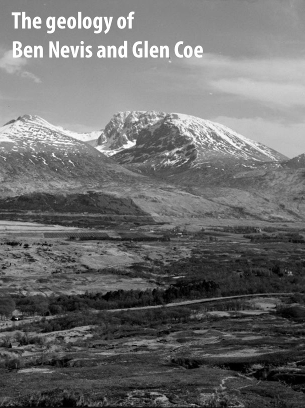
(Front cover). Ben Nevis from the Great Glen, view from Muirshearlich, Banavie. Inverness-shire. The Ben Nevis Complex, a sequence of granitic intrusions with central cauldron subsidence of Lower Old Red Sandstone lavas and Dalradian metasedimentary rocks.

(Plate 1) Ben Nevis with hanging corrie and River Nevis [NN 200 680] disappearing into Nevis Gorge.

(Plate 2) 1. Hanging portion of River Leven with dam site of Blackwater Reservoir [NN 250 605]. 2. Stob Bàn, Near Watershed of Lairigmòr Valley, showing comparatively recent landslip.

(Plate 3) Map of Ballachulish District.

(Plate 4) Map Of Lower Glen Creran.

(Plate 5) Sgùrr A' Mhàim across Allt Coire A' Mhail Folded Glen Coe Quartzite.

(Plate 6) Gearr Aonach [NN 160 555] And Aonach Dubh: Glen Coe "sisters" Largely rhyolite lavas.

(Plate 7) Melting of Three Waters, Glen Coe; and Rock-Fall, Allt Core Gabhail.

(Plate 8) Stob Dearg Rhyolite lavas (crags) on schists (grass covered). Fossils at +.

(Plate 9) Glen Coe Fault, Stob Mhic Mhartuin [NN 207 575].

(Plate 10) Allt a' Mhuilinn [NN 161 730]: Ben Nevis Volcanics on right, and Inner "Granite" on left, meeting in stream.

(Plate 11) Photomicrographs of Kentallenite, Appinite and rocks connected with the Fault-Intrusion of Glen Coe. × 10 Dia. Explanation of (Plate 11) 1. Kentallenite, type quarry (S7053) [NN 009 577]. Olivine, with black cracks; augite, idiomorphic, grey; felspar, clear; biotite, pale or dark. (photo M.2436; p. 212). 2. Appinite, N. of Leacantuim [NN 117 577], Glen Coe (S11036) [NN 1152 5810]. Hornblende, mainly dark; felspar and quartz, clear. (M.2441; p. 215). 3. Junction of flinty crush-rock (left) with chilled Fault-Intrusion (right) at Boundary-Fault, Stob Mhic Mhartuin (S13403) [NN 207 575]. The minute clear grains in the flinty crush-rock are quartz. The four larger crystals in the same are xenocrysts of felspar derived from the Fault-Intrusion. The four crystals in the Fault-Intrusion are felspar phenocrysts, one showing dark. (M.2444; p. 162). 4. Junction of pelitic hornfels (upper third of photo) with lit par lit vein (remainder) in xenolith in Fault-Intrusion, taken from quenched zone at Boundary-Fault, An t-Sròn (S10311) [NN 136 558]. Due to quenching the vein has completed its crystallisation by developing spherulites — right at bottom corner and left at margin against hornfels. (M.2445; p. 216). 5. Fault-Intrusion (felspar shows grey) detaching quartz xenocrysts (clear) from quartzite xenolith. Permeation area north of Glen Coe (S11517b) [NN 1592 5970]. (M.2440; p. 219). 6. Greatly sheared xenolith of basic lava (right), recrystallised with much minute hornblende. It is enclosed in chilled Fault-Intrusion (left), loaded with clear xenocrysts of quartz, and has been carried just inside Cauldron-Subsidence of Glen Coe at An t-Sròn (S11905) [NN 1362 5502]. (M.2439; p. 217).
(Plate 12) Photomicrographs of Leven Schists before and after contact-alteration. × 21 Dia. A. Not contact-altered, Glen Leac na Muidhe (S11618) [NN 1126 5486]. Porphyroblasts of biotite, garnet and magnetite in well foliated base of muscovite, quartz and magnetite. B. Slightly contact-altered, ¾ mile from Cruachan "Granite", Glen Etive district (S8270) [NN 112 505]. Pseudomorph, largely of cordierite and magnetite, after garnet in well foliated base of muscovite, quartz and magnetite. C. Completely reconstructed to cordierite-andalusite-hornfels, near Ben Nevis "Granite", Aonach Beag (S13837) [NN 1935 7186]. Cordierite, pale, N.W. half; andalusite, darker, S.E. half; biotite and magnetite, dark to black.
(Plate 13) An Steall, The Waterfall of a valley hanging to Glen Nevis Water-worn crags on left due to stream cascading down marginal crevasse; Roche moutonnee, Glen Nevis, by roadside above Polldubh [NN 141 686] Note gap on "sloss" side due to plucking.

(Title page).