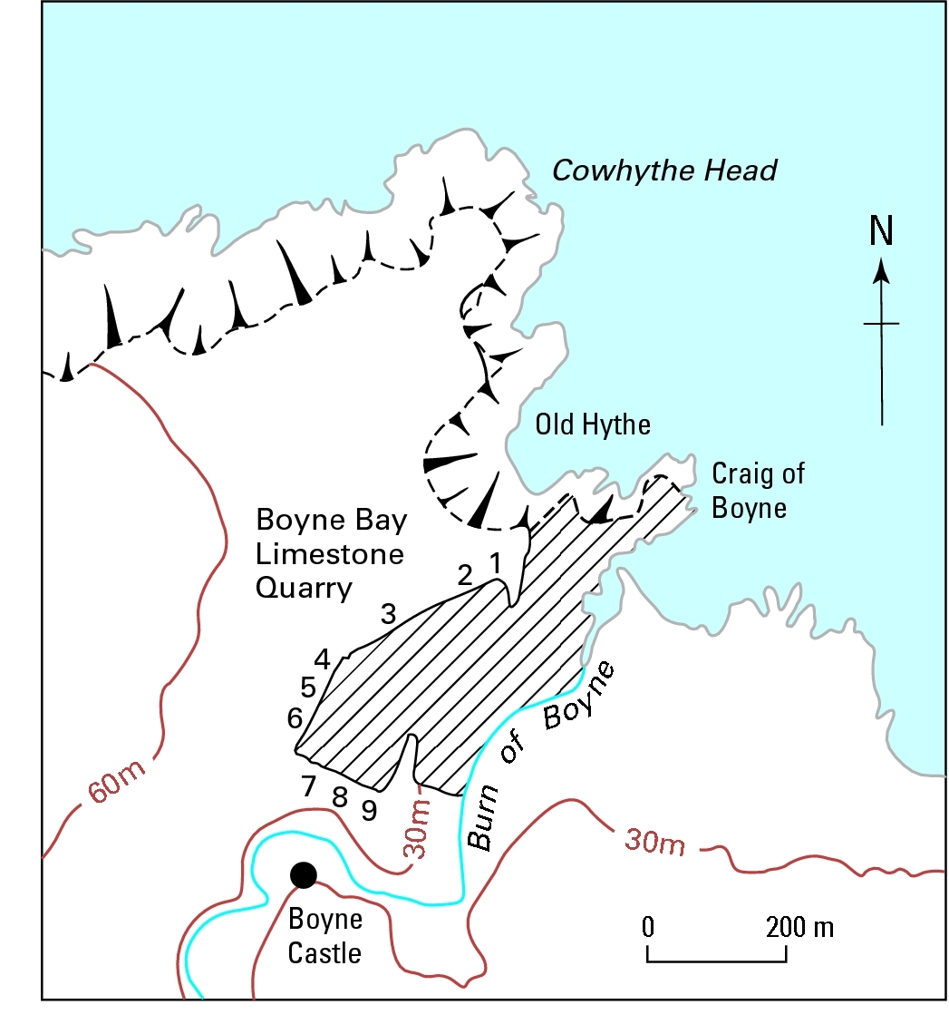
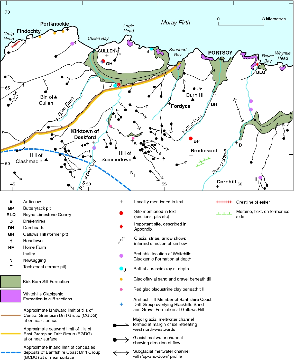
Site 2 Boyne Limestone Quarry
The Quaternary sequence here
The superficial deposits in the Boyne Limestone Quarry were first described by H H Read (1923), who noted that gravelly material at the base was overlain by dark blue clay, 'probably of the (glaciolacustrine) Coastal Deposits', and capped by brown sandy boulder-clay with 'Huntly' erratics. This description was later amplified as follows (Peacock, 1966):
| 6 | Peaty soil | 0.6 |
| 5 | Horizontally bedded sand, silt, and gravel | 0–1.2 |
| 4 | Grey silty till with troctolite boulders grading downwards into 3 | 1.5 |
| 3 | Dark grey clayey till with shell fragments | 3.0–4.6 |
| 2 | Dark grey shelly silt and clay, in part till-like and in part laminated,with pockets of shelly gravel especially at the base | 1.5–3.7 |
| 1 | Light brown till 0–3.7 | |
| Rock, partly weathered |
Peacock (1966) confirmed Read's (1923) view that the uppermost till in the quarry (unit 4) contains erratics from the south (troctolite). However, on the basis of the incorporated shell fragments, Peacock (1971) suggested that the uppermost till was merely a separate facies of the underlying shelly till derived from the north-west. He concluded that the troctolite erratics had been reworked from older deposits to form a 'fossil' boulder train. He also suggested that an irregular bed of clay associated with the shelly till was a rafted marine deposit in the process of becoming till, rather than in situ glaciolacustrine sediment. This is now known to be only partly correct, since much of the clay is now believed to be reworked from Mesozoic mudstone (see below). Peacock also suggested that unit 1, which was decomposed, had been subjected to prolonged subaerial weathering prior to the deposition of the shelly till. However, later work indicates that the weathering in unit 1 was less intense than previously thought, the weathered appearance partly reflecting the incorporation of weathered bedrock into the till (Peacock in Gordon, 1993a). Connell and Hall (1984b) suggested that the weathering profile is truncated and that the till surface is covered by a thin (20 cm) layer of brown silt, and by fine-grained sand infilling shallow depressions. They also suggested that unit 2 can be subdivided into a lower unit of sheared and interbedded layers of red and brown silt and fine-grained sand, and an upper unit of dark grey, clayey till.
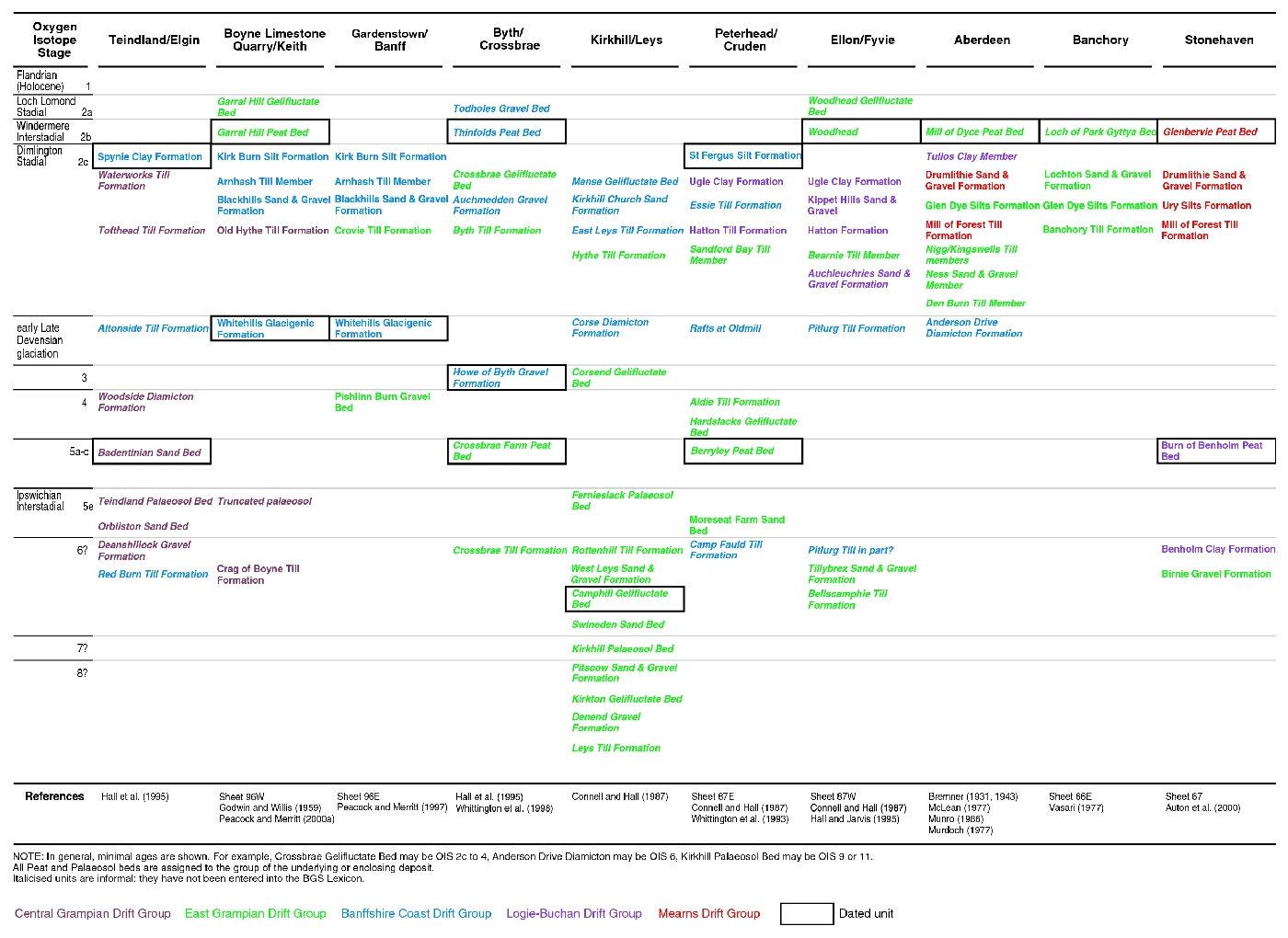
Lithostratigraphy
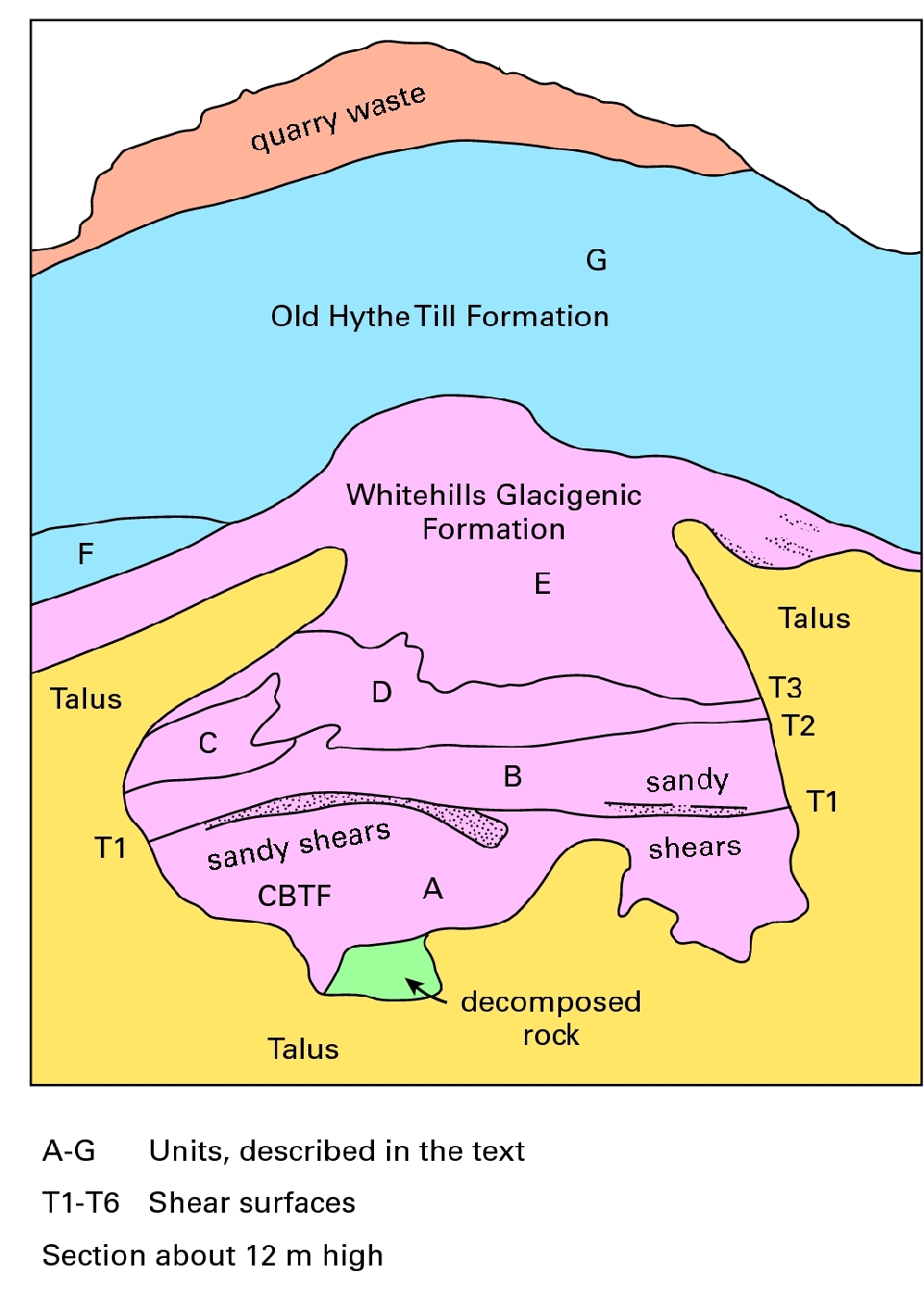
Recent examination has, in general, sustained the work reported above, but has stressed the importance of glaciotectonics (Peacock and Merritt 2000a, b). For example, unit 5 is now interpreted as a raft within the tectonised sequence
Craig Of Boyne Till Formation (Central Grampian Drift Group)
This unit, up to 5 m thick, is equivalent to unit 1 (light brown till) of Peacock (1966) and is a massive, matrix-supported diamicton (Dmm) with subsidiary lenses of sand and fine-grained gravel. The diamicton is a clayey, sandy gravel, dark yellowish brown (10YR 4/2), to dark yellowish orange (10YR 6/6) in colour with rusty orange mottling. The gritty sandy matrix is probably derived from the underlying decomposed rock. The clasts are up to cobble size with some dispersed boulders; they comprise quartzite, psammite and vein quartz, together with calc-silicate rock (locally dominant), gabbro, and sparse pink siliceous sandstone. The calc-silicate and gabbro clasts vary from moderately fresh, with weathering rinds, to thoroughly decomposed. The till invariably rests on a surface of partly to thoroughly decomposed calc-schist and limestone.
Whitehills Glacigenic Formation (Banffshire Coast Drift Group)
This sequence, up to 7 m thick, is equivalent to units 2 and 3 of Peacock (1966) and comprises the following elements (in variable stratigraphical order).
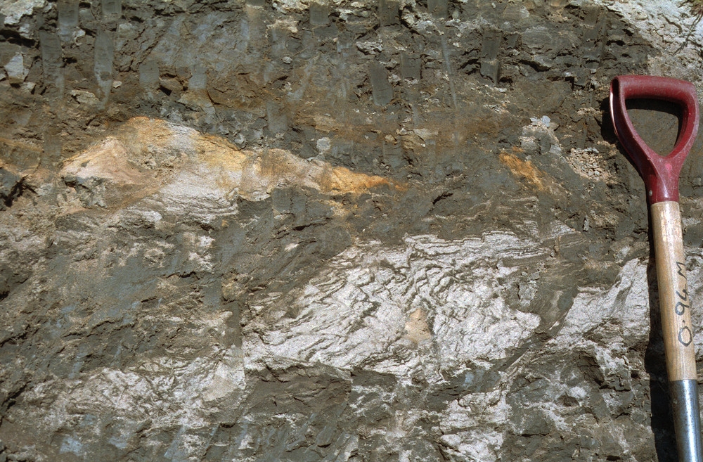
- Silty clay, very compact, stiff, massive, locally fissile, blocky fracture, olive black (5Y 2/1) with subsidiary medium brown silty clay. Dispersed well-rounded pebbles typically 5 cm across. Sparse shell fragments, including Arctica islandica. Lenticles, laminae, and thin bands of fine- to medium-grained sand, passing by interbanding into larger bodies of sand, with shell fragments in places. Clasts include psammite, quartzite, sparse pink sandstone, dark shale and lignite. Numerous Jurassic to Early Cretaceous palynomorphs found in detailed examination of one sample, together with rare foraminifera (Elphidium excavatum clavatum and Haynesina orbiculare) (Riding, 1998; Wilkinson, 1998).
Diamicton and pebbly silty clay, colours and clast content as above, withsandy stripes up to 3 cm thick.- Sand and gravel, locally with sedimentary structures preserved.
- Rafts, more or less deformed, of the underlying Craig of Boyne
Till Formation and associated sand.
Old Hythe Till Formation Till Formation (Central Grampian Drift Group)
This unit corresponds to the upper till (Unit 4) of Peacock (1966) and is up to 5 m thick. It is a matrix-supported diamiction, which is very stiff, massive to crudely laminated (sheared), inhomogeneous, silty, stony clayey and with local sandy lenses. It is dark grey to dark yellowish brown (10 YR 4/2), but locally dark greenish grey (5GY 4/1 to 5G 4/1). Clasts are generally angular to well rounded, mainly less than 35 cm, but locally up to 1.5 m across near the top. Apart from the boulders, which are mostly gabbro, the clasts are of psammite and quartzite (locally dominant), with some pink granite, red-brown and brown sandstone, pelite, calc-silicate rock and amphibolite. There are also sparse boulders of troctolite. Sparse shell fragments occur throughout at the northern end of the quarry, but are apparently absent at the southern end. The till is weathered to a depth of 1.5 to 2.0 m at the top where it is decalcified, mottled and contains partially decomposed clasts of gabbro and calc-silicate rock. Vertical fissures are prominent in the weathered zone.
Site description
The total length of the exposure
A section 10 m from the north-eastern end of the quarry
At locality 6, some 210 and 240 m from the north-eastern corner of the quarry, a 5 m-thick body of sand was recorded in June 1997. It lay above dark clay (unit E of locality 1) to reach the present-day soil over part of the exposure, wedging out at the northern end below the upper till of locality 1 (unit G). In October 1997, however, after the face had been taken back, it appeared to be entirely overlain by till of the
Details of other localities sited on
Genesis and age
The clasts in the Craig of Boyne
The lithology of the
The derivation of the Old Hythe