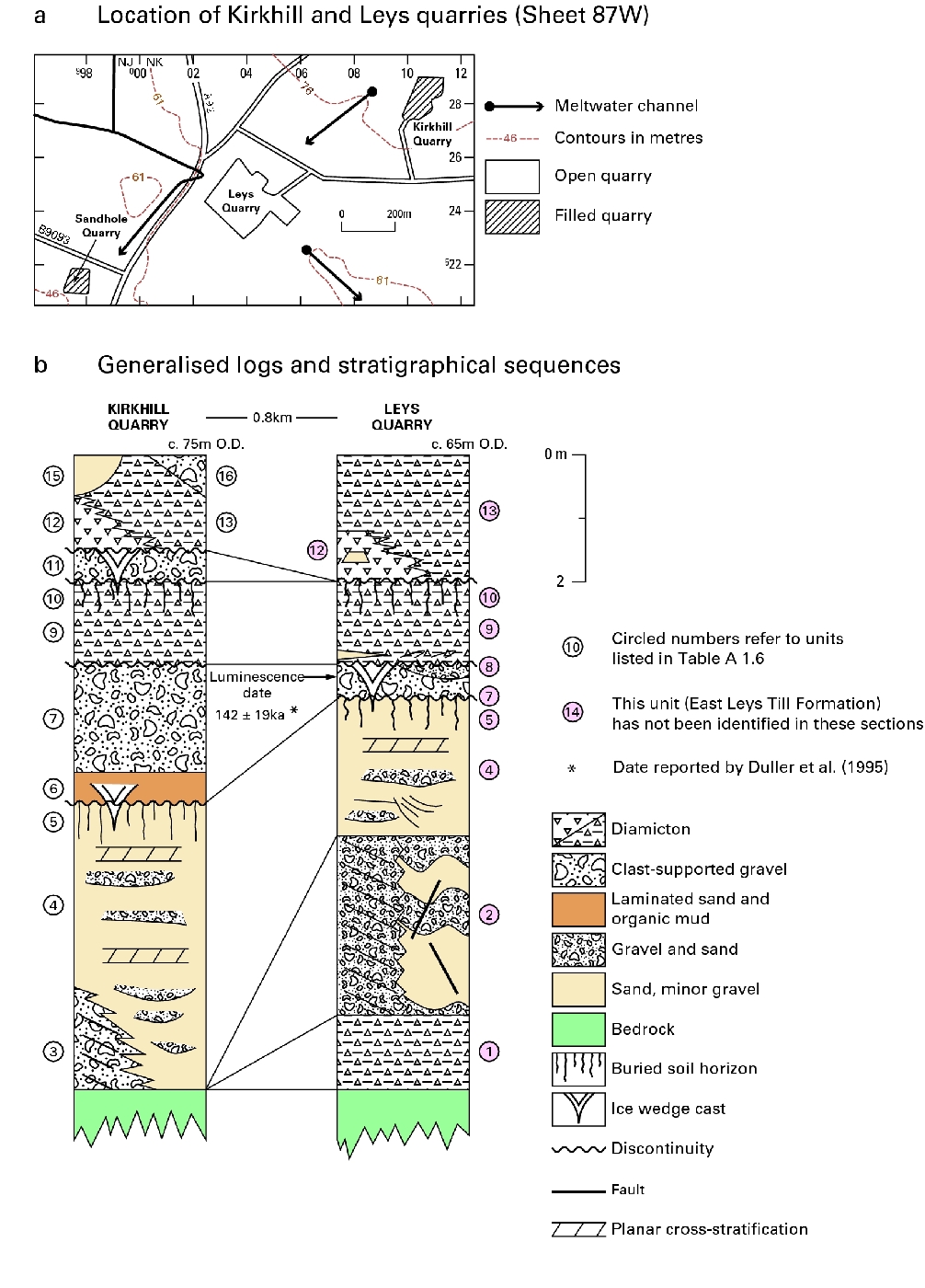
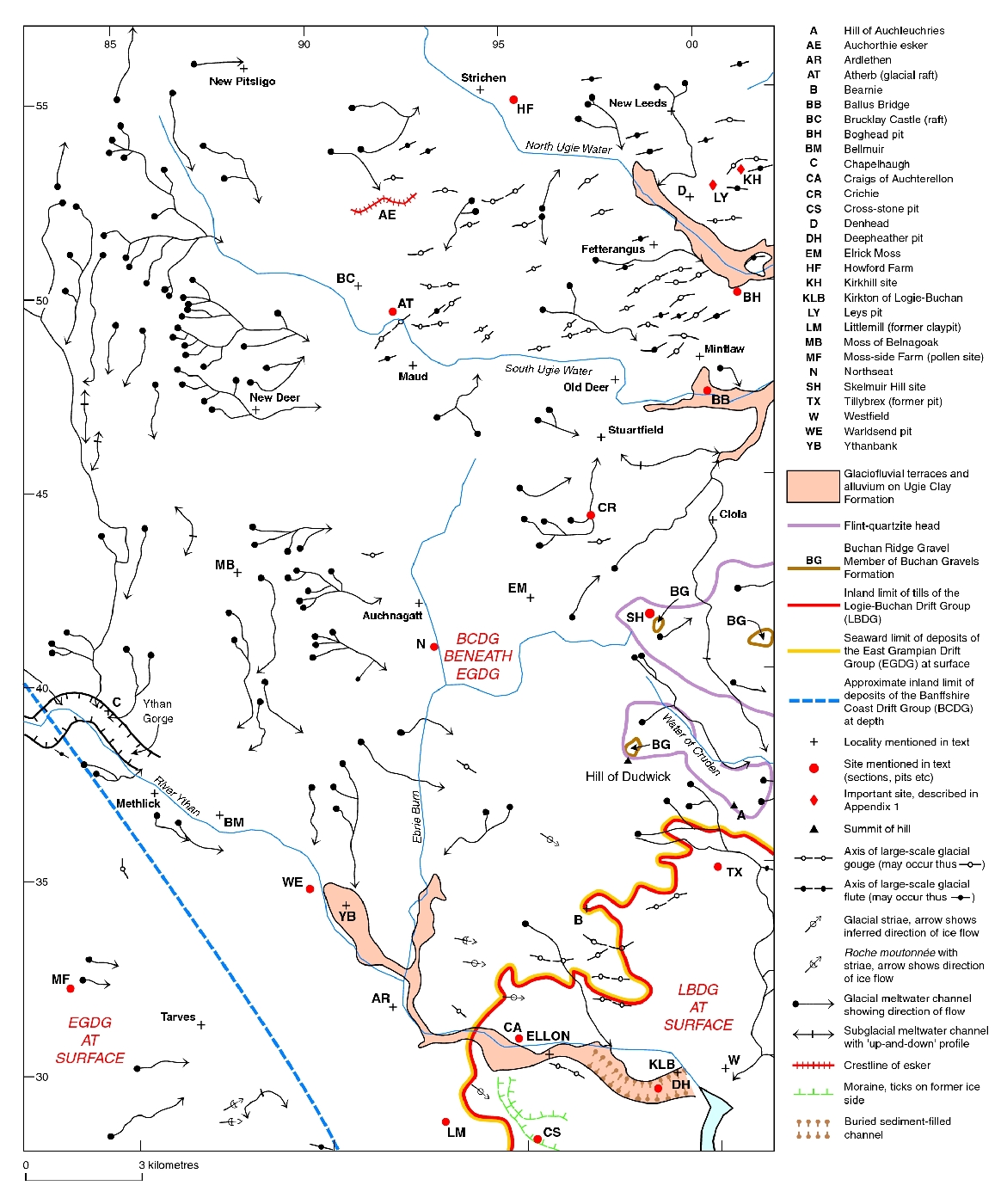
Site 7 Kirkhill and Leys quarries
The Middle and Late Pleistocene deposits preserved in and around Kirkhill
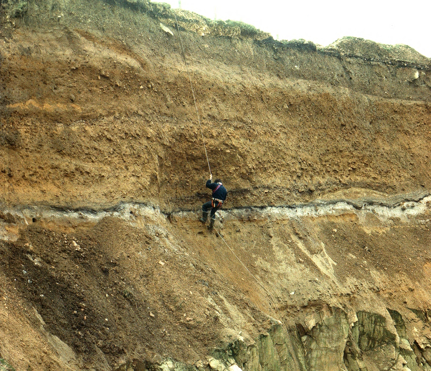
Kirkhill Quarry
Lithostratigraphy
The lithostratigraphy described below generally follows that set up in the papers cited above. In order to adhere more closely to internationally agreed guidelines on lithostratigraphical nomenclature, new names have been proposed by Sutherland (1999). The latter have been adopted where appropriate into the present scheme presented in
Unit 1 - Leys Till Formation Till Formation
Pits opened in the floor of Leys Quarry revealed up to 2.5 m of till resting on weathered bedrock. The till is a matrix-supported silty clayey sandy diamicton with pebbles of mainly quartzite and basic igneous rocks. Matrix colour is dominantly olive brown (2.5Y 4/4), but in its upper part the diamicton shows extensive yellowish brown (10YR 5/6) to strong brown (7.5YR 4/6) mottling and contains many grussified basic igneous clasts. It passes down into grussified basic igneous and kaolinised psammite bedrock and contains reworked masses of this material, demonstrating that weathering of the bedrock predates deposition of the till (Hall et al., 1989).
The Leys
Unit 2 - Denend Gravel Formation (Leys Lower Gravels)
The overlying Denend Gravel Formation comprises 3 to 5 m of coarse felsite-dominated pebble to boulder gravel, with interstratified sand units. Clast shapes are dominantly subrounded to rounded. Clast lithologies comprise over 90 per cent felsite, mainly of very local origin, together with intermediate igneous rocks, gneiss, vein quartz and schist. The main primary structure in the gravels is crude parallel stratification. In contrast, large scale deltaic planar cross-stratified gravels with thick fining-upwards foresets dipping at 20° to 25° towards the west-south-west occur in the north-western corner of Leys Quarry. Massive, matrix-supported units of coarse gravel are also locally developed. Orientation of both planar cross-stratified gravels and trough cross-stratified sands indicates deposition by water moving towards the west and south-west.
Postdepositional disturbance of the gravels is widespread. Bedded sands and gravels show low amplitude flexures and higher amplitude folds, and minor faults are widespread within sand units. The folded gravel beds are further disrupted by large wedge structures with upper widths that may exceed 10 m. The wedges are infilled with sand and gravel of varied character ranging from downwarped beds of stratified gravel to unstratified, yet crudely sorted, granule to boulder gravel (Hall and Connell, 1986, fig.4). Truncation of anticlinal fold crests and the thickness of gravel beds preserved by downwarping and collapse in the wedge structure indicate that at least several metres of gravel were eroded prior to deposition of flat-bedded sands and gravels, probably part of the
Postdepositional folding, faulting and development of wedge structures are interpreted as the result of melt-out of ice blocks originally buried within the gravels. The coarse, but variable calibre of the gravels indicates high, fluctuating palaeoflow regimes. Sedimentary structures indicate a braided channel environment, with meltwaters draining to the north-west, with subsidiary deposition within a proglacial lake. The gravels probably formed as part of a valley sandur extending from an ice margin lying relatively close to, and east of, Leys. Importantly, the easterly source of meltwater suggests that the ice mass was not that which deposited the underlying westerly derived
Unit 3 - Kirkton Gelifluctate Bed (Kirkhill Gelifluctate 1)
In the south-east face at Kirkhill, Unit 4 is underlain by and interbedded with angular felsite rubble up to 2 m thick derived from adjacent intensively frost-shattered bedrock in channel walls. Clasts in the rubble show a well developed downslope fabric, indicating transport by avalanche or gelifluction.
Unit 4 - Pitscow Sand And Gravel Formation (Kirkhill Lower Sands and Gravels)
This unit comprises up to 4 m of light olive brown sand with thin gravel beds. Most of the sands are horizontally stratified, but trough and planar cross-stratification occurs locally. In places, the sands seem to have been deposited in a series of stacked, wide and shallow channels, with thin gravel lags evident at their bases. Cross-stratification suggests transport from the east.
This unit is interpreted as a periglacial fluvial or proglacial glaciofluvial deposit. Deposition of the basal beds took place under periglacial conditions judging from the occurrence of syndepositional ice-wedge casts. The declining numbers of angular clasts in the upper beds at Kirkhill, together with the absence of ice-wedge casts and other features of cryoturbation at these levels may indicate amelioration of climatic conditions.
Unit 5 - Kirkhill Palaeosol Bed (Kirkhill Lower Buried Soil )
The
At both Kirkhill and Leys, bleaching and iron/manganese staining associated with localised cementation occur extensively in the gravels and sands of Units 2 and 4. The Kirkhill Palaeosol seems therefore to be part of a weathering profile that in places extends throughout the entire thickness (about 4 m) of gravels.
Micromorphological analysis of the palaeosol has also revealed structures typical of soils of arctic environments (Connell and Romans, 1984, p.70). Superimposition of periglacial soil characteristics on an earlier interglacial soil horizon seems to have produced a composite soil horizon. The stratigraphical position of the palaeosol indicates that it developed during a pre-Ipswichian interglacial, but not necessarily the Hoxnian (OIS 11) as originally suggested (Connell et al., 1982; Hall and Connell, 1991).
Unit 6 - Swineden Sand Bed (Kirkhill Organic Muds and Sands)
At Kirkhill, the truncated
The organic mud contains pollen of Poaceae, together with a marked arboreal component of mainly Pinus and Alnus, together with charcoal. The overlying sands show a reduction in arboreal pollen and an increase in grasses and Calluna, possibly reflecting the establishment of an open, treeless environment (Connell et al., 1982). Sampling of an equivalent organic sequence in the west face at Kirkhill suggests that two components exist in the pollen spectra. Open, grassland types represent pollen contemporaneous with sedimentation of the sands. Recycled pollen, with an important arboreal component, is perhaps derived from older soil horizons at the site (information from J J Lowe, Royal Holloway University of London, 1990).
Initial radiocarbon dating gave finite ages for three samples, but contamination was suspected (Connell et al., 1982). Later dating of a much larger sample gave an age of over 47 360 radiocarbon years BP (SRR–2416) and confirmed that the sediments are beyond the range of radiocarbon dating (Hall, 1984).
Unit 7 - Camphill Gelifluctate Bed (Kirkhill Gelifluctate 2/3)
At Kirkhill Quarry, up to 2.5 m of periglacial mass movement deposits are developed above the organic
Unit 8 - West Leys Sand And Gravel Formation (Leys Upper Sands and Gravels)
The
Unit 9 - Rottenhill Till Formation Till Formation (Kirkhill Lower Till )
This is a yellowish brown (10YR 5/4) matrix-supported, silty sandy diamicton. Clasts include mainly pebbles and cobbles of quartzitic metasedimentary rock, pelitic schist and felsite. Clasts of red granite are common at Kirkhill and are probably derived from the White Cow Wood area to the west. Present also are red-stained quartzite cobbles, probably derived from Devonian conglomerates, and grey granite from the Strichen intrusion to the north-west. Clay mineralogy is dominated by kaolinite and illite. Normally, the till is massive, with poorly defined subhorizontal jointing, and a weak north-west–south-east fabric (Connell, 1984b, p.64). Both clast lithology and fabric indicate that the till was deposited by ice moving from the north-west or west.
Unit 10 - Fernieslack Palaeosol Bed (Kirkhill Upper Buried Soil )
Evidence of soil development on the surface of the underlying
- in situ grussification of basic igneous and granite clasts
- horizon development, with formation of strong brown (7.5YR 5/6) colours in the upper 70 cm of the profile and passing down into yellowish brown(10YR 5/4) hues in less weathered material
- development of coarse yellowish red (5YR 4/6–5/8) and greyish brown to brown (10YR 5/5–5/3) mottling owing to iron oxide segregation
- clay mineralogy, with alteration of illite to interstratified mica-smectite in the preserved upper 0.3 m of the profile
- soil micromorphology, with the presence of disrupted void argillans in thin section (Connell and Romans, 1984, p.75)
The palaeosol is truncated, but resembles the B and C-horizons of gleyed brown earths developed on similar parent materials in eastern Scotland during the Holocene (Connell and Romans, 1984, p.76). Support for this interpretation is provided by the presence of Alnus, with Betula and coryloid grains from a single sample in the profile (Connell et al., 1982). The palaeosol appears to be quite widely preserved south and west of Kirkhill as a mottled zone in the upper part of the till. On the simplest interpretation and in the light of the luminescence date from Unit 7, it was probably formed during the Ipswichian Interglacial (OIS 5e).
Unit 11 - Corsend Gelifluctate Bed (Kirkhill Gelifluctate 4)
A range of periglacial deposits and features formed in the interval prior to deposition of Unit 12 and after formation of the weathering profile within Unit 10. In stratigraphical order from oldest to youngest these are:
- Truncation and cryoturbation of the
Fernieslack Palaeosol Bed , with erection of pebbles in the uppermost 0.6 m. - Deposition of a thin (0.6–0.8 m) brownish yellow (10YR 5/3) silty gelifluctate unit with angular felsite clasts (
Corsend Gelifluctate Bed ). - Incipient pedogenesis under periglacial conditions, with development of silt droplet fabrics in the gelifluctate.
- Ice-wedge growth. The presence of an ice-wedge cast extending downwards from the surface of the gelifluctate and filled with matrix material from Unit 13 indicates that glaciation of the site began while ground ice remained in the wedge (Connell, 1984c, p.68).
Unit 12 - Corse Diamicton Formation
This unit has been observed to overlie both sediments of Unit 11 and Unit 9. In turn, it is known at both Kirkhill and Leys Quarries to be either overlain by the
The Corse
Unit 13 - Hythie Till Formation Till Formation (Kirkhill Upper Till )
This unit is a mainly brown (10YR 4/3) massive, sandy silty matrix-supported diamicton, up to 3 m thick. Clast lithology is dominated by psammite and pelitic schist, with basic igneous rocks and felsite. A single clast of rhomb porphyry typical of those found in Norway was recovered from this unit. A characteristic feature of the till at Kirkhill is the presence of boulders of basic igneous rock that were probably originally formed as corestones. Clay mineralogy there is dominated by an interstratified smectite/chlorite mineral. At Leys, the till contains rare clasts and thin lenses of red clay (Hall and Connell, 1986, p.23).
The dominance of quartzitic and basic igneous rocks in the
Unit 14 - East Leys Till Formation Till Formation
This till is a very dark grey (2.5YR N/3) massive clayey silty diamicton with scattered matrix-supported pebbles and cobbles. Clast lithologies are dominated by dark grey-stained gneissose quartzite and psammite, with chalk, pelites and reddish brown (possibly Devonian) sandstone. The till is weathered in its upper 2.5 m, with grussified basic igneous, softened chalk clasts, the absence of shell fragments and development of reddish brown (2.5YR 4/4) to dark greyish brown (10YR 4/2) hues. The clay mineralogy of fresh diamicton comprises more or less equal proportions of interstratified mica smectite, illite and kaolinite.
Striated shell fragments appear below a depth of 2.5 m and include specimens of Macoma sp. and Astarte sp. The matrix contains reworked Late Jurassic/Early Cretaceous dinoflagellate cysts, Mesozoic and Tertiary pollen, and Quaternary foraminifera (information from R Harland, BGS, 1980 and L A Riley, Bovingdon, Herts, 1997). Together these organic remains indicate derivation of the matrix from Mesozoic mudstone, early Tertiary sediments and Quaternary glaciomarine and marine muds in the Moray Firth basin. Southward transport by ice from the Moray Firth is supported by the presence of chalk clasts and by the transport of dark gneissose rocks comparable to the Inzie Head Gneiss of the Fraserburgh area.
Unit 15 - Kirkhill Church Sand Formation (Kirkhill Upper Sands)
These sparsely developed sands and subordinate gravels overlay the Corse
As no diamicton similar to the
Unit 16 - Manse Gelifluctate Bed (Kirkhill Gelifluctate 5)
This unit overlies the Hythie
Discussion
The Pleistocene sequence in the Kirkhill area comprises a record of three complex stadial–interstadial–interglacial cycles. In the oldest cycle, the till of Unit 1 is succeeded by the outwash gravels of Unit 2, then by the periglacial deposits of Unit 3 and at the base of Unit 4 and, lastly, by a period of interglacial conditions during which the Kirkhill Palaeosol developed. A second cycle begins with the overlying organic sands and muds of Unit 6, which record a climatic deterioration, which then deepens to provide the periglacial slope deposits of Unit 7 and culminates in glaciation of the site, with deposition of Unit 9, the Rottenhill
The youngest cycle commences with the varied periglacial deposits of Unit 11. This phase of climatic decline terminates with the deposition of the
Chronostratigraphical information is provided by the luminescence date of 142 ± 19 ka BP (Duller et al., 1995) from sandy gelifluctate in Unit 7, which together with the overlying Rottenhill
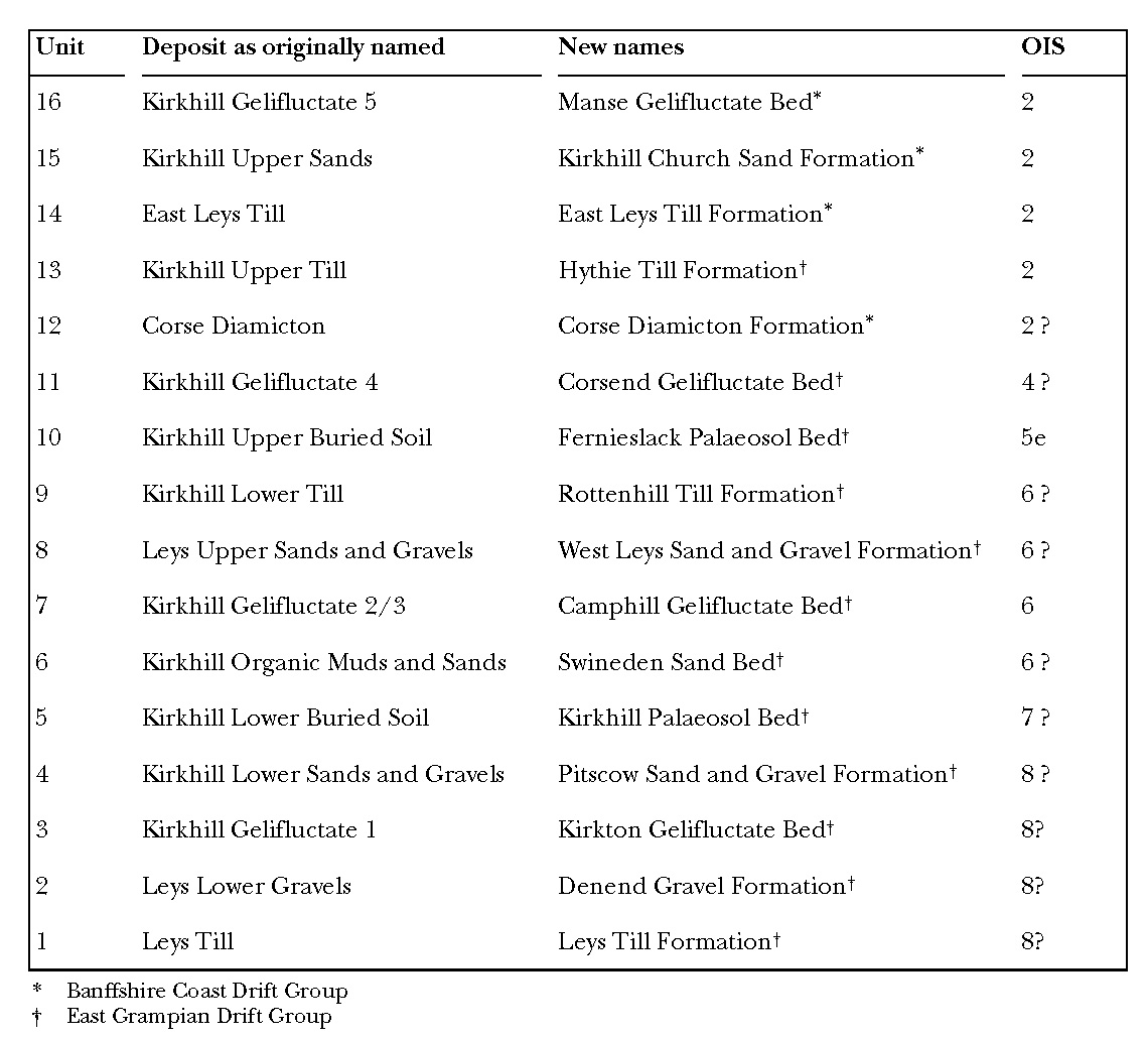
(Table A1.6) Lithostratigraphical units at Kirkhill and Leys Quarries.
| Unit | Deposit as originally named | New names | OIS |
| 16 | Kirkhill Gelifluctate 5 | 2 | |
| 15 | Kirkhill Upper Sands | Kirkhill Church Sand Formation* | 2 |
| 14 | East Leys |
East |
2 |
| 13 | Kirkhill Upper |
Hythie |
2 |
| 12 | Corse |
Corse |
2 ? |
| 11 | Kirkhill Gelifluctate 4 | Corsend Gelifluctate Bed† | 4? |
| 10 | Kirkhill Upper Buried |
Fernieslack Palaeosol Bed† | 5e |
| 9 | Kirkhill Lower |
Rottenhill |
6 ? |
| 8 | Leys Upper Sands and Gravels | West Leys Sand and Gravel Formation† | 6 ? |
| 7 | Kirkhill Gelifluctate 2/3 | Camphill Gelifluctate Bedt | 6 |
| 6 | Kirkhill Organic Muds and Sands | Swineden Sand Bed† | 6 ? |
| 5 | Kirkhill Lower Buried |
Kirkhill Palaeosol Bed† | 7 ? |
| 4 | Kirkhill Lower Sands and Gravels | Pitscow Sand and Gravel Formation† | 8 ? |
| 3 | Kirkhill Gelifluctate 1 | Kirkton Gelifluctate Bedt | 8? |
| 2 | Leys Lower Gravels | Denend Gravel Formationt | 8? |
| 1 | Leys |
Leys |
8? |
|
|||