Appendix 1 The geological maps
Without the geological map, to which it refers throughout, upon which it is based, and of which it is an explanation, very little use can be made of this book. This Appendix explains the relations between the different maps which have been employed for different purposes, some of the methods used in their construction (whereby they can be interpreted), and the ways in which they can be obtained.
Ordnance maps on the following scales have been made use of:
One Inch to One Mile. Fraction of Nature = 1/63360 = .00001572
Six Inches to One Mile. Fraction of Nature = 1/10560 = .00009469
25.344 to One Mile. Fraction of Nature = 1/2500 = .0004
Only the two larger scales have been employed in the actual geological surveying on the ground. But the book always refers to the new one-inch map
The One-Inch maps
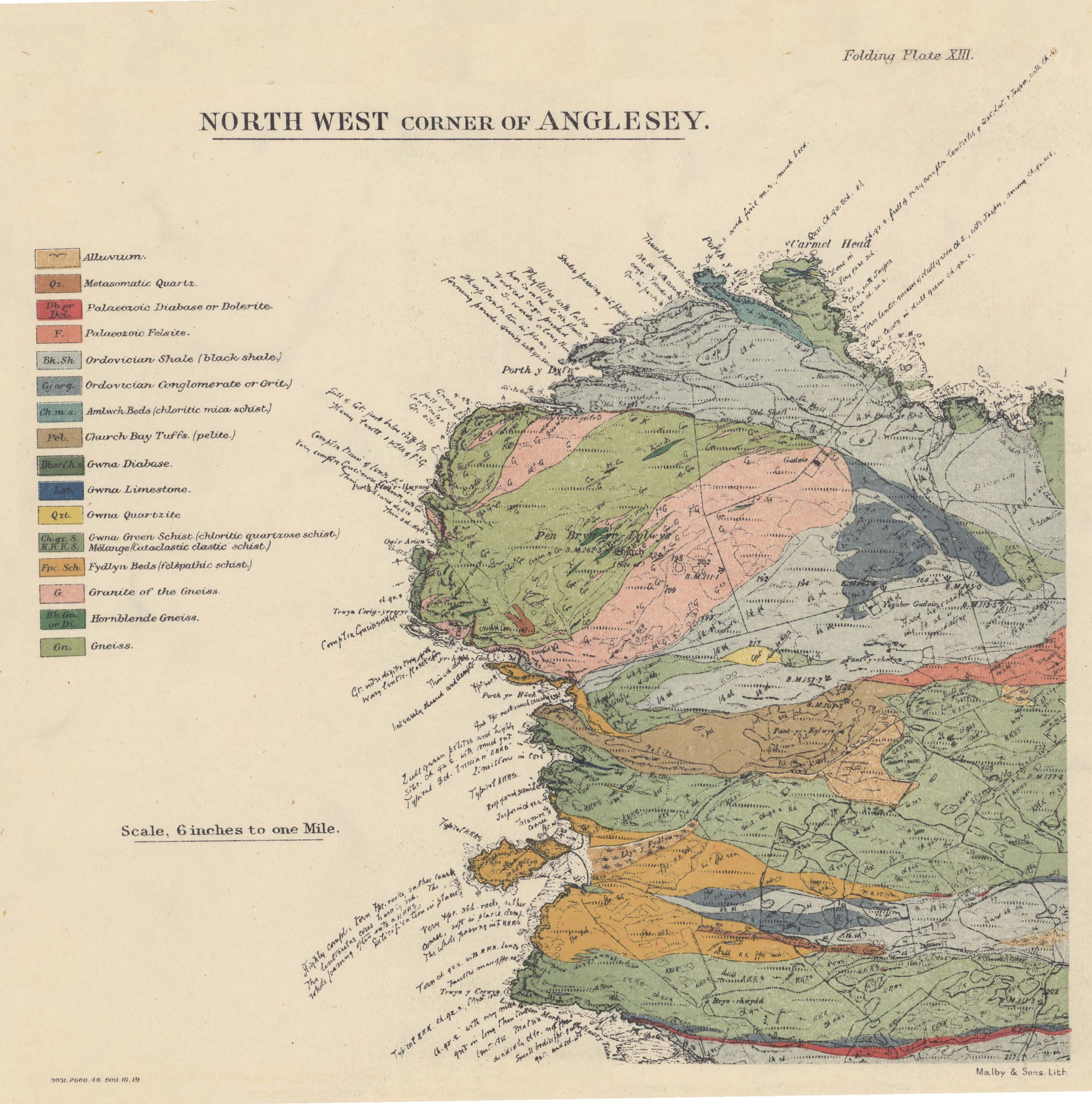
On the one-inch Ordnance maps as usually issued, Anglesey is divided between five different sheets of the new series. For the present purpose, however, the Ordnance Survey have combined Sheets 92, 93, and portions of 94, 105, 106, so as to bring the whole of Anglesey within a single sheet. They also kindly engraved a number of additional place-names. To this special sheet have been added the geological lines, symbols, and colours, thus constituting the new geological one-inch map of the IslandNo geology is shown on the portion of the mainland which falls within it.. The lines are a reduction from the six-inch geological maps; and, in parts where there is much detail, they have not only been reduced, but abstracted and generalised.
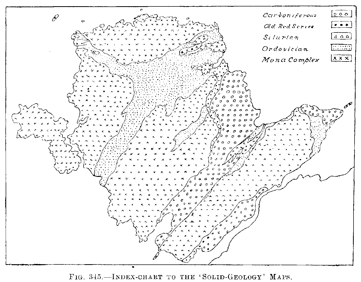
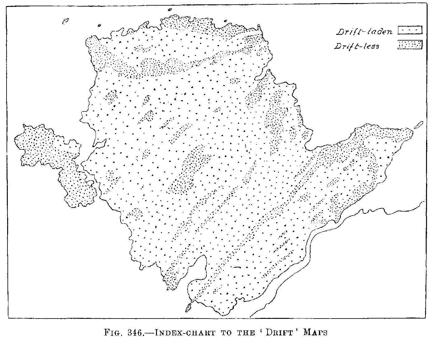
The 'Solid' (i.e. Pre-Glacial) formations are shown by colours with symbols; the Glacial Drifts by dotted stipples, through which the colours are seen as through a veil; driftless areas being un-stippled. Out of so many colours, a few are inevitably somewhat alike; but such can be distinguished, if not by a formation-symbol, then by the description in the text.
Faults, Thrusts, and other ruptures have not been distinguished by any special kind of line. In the Mona Complex (particularly in its Gwna Mélange) they are so numerous that we have failed to devise any method of distinguishing them which would not have brought confusion into the map. And, obviously, ruptures of later date could not be accorded a treatment which was denied to those of the Mona Complex. No course, consequently, remained but to show them all as ordinary black-ink lines. The nature of many of them, however, is quite evident upon the map itself; and where such is not the case, the verbal explanations or the sections given in this book will suffice to elucidate it.
Where Obtainable — Both editions are obtainable in the same way as copies of this book (see Title-page). Some of the Local Agents are:Aberystwyth: S. V. Galloway. Bangor: Jarvis & Foster. Chester: Philipson & Golder. Liverpool: Philip, Son & Nephew, Ltd. Manchester: J. E. Cornish, Ltd.
The maps used in the field
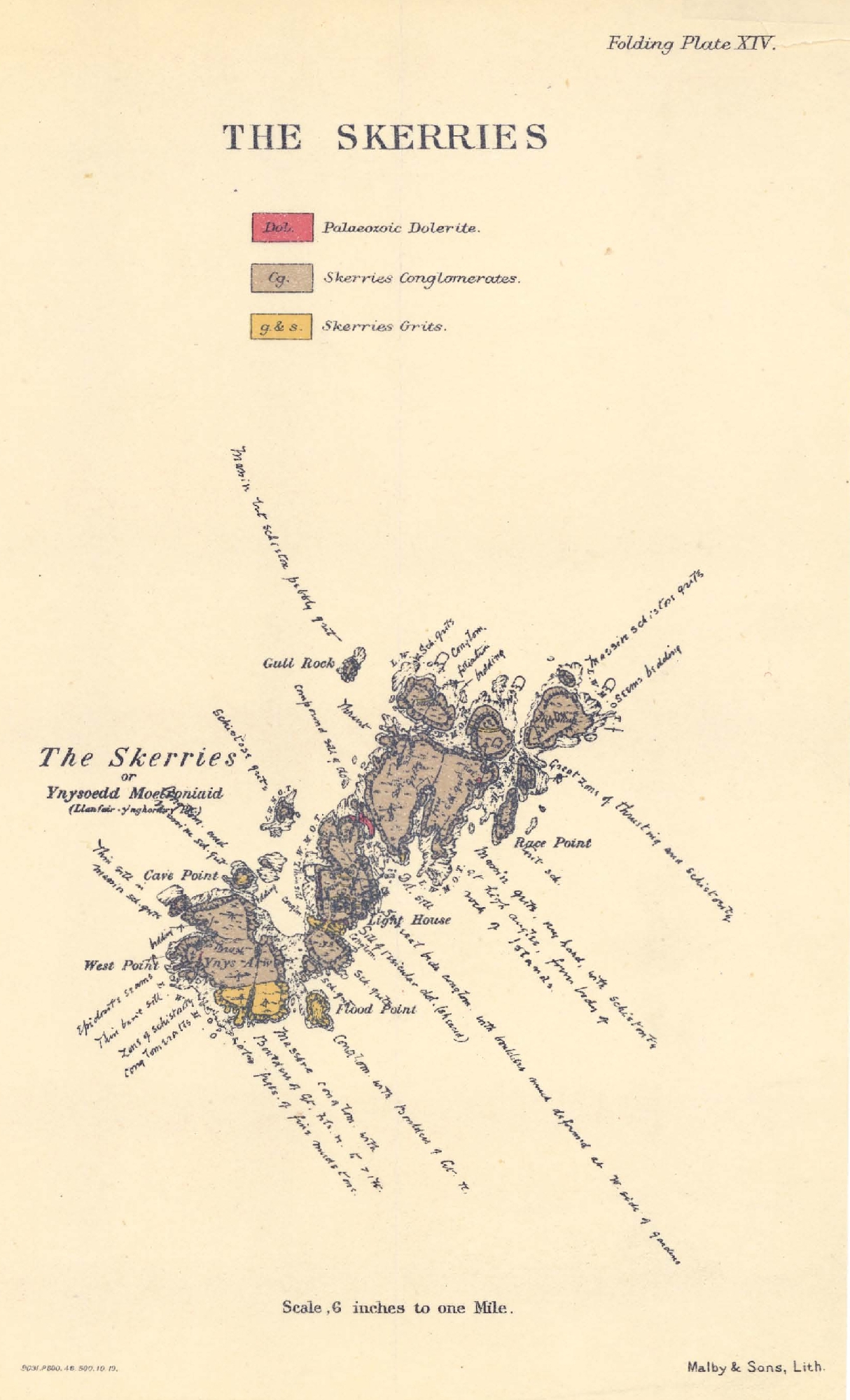
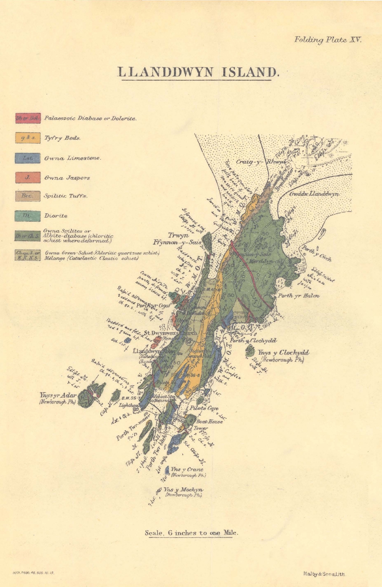
The Six-inch Maps — The Island has been geologically surveyed throughout on the six-inch scale. The maps (Anglesey 1–25) used in the field were those of the first (1888) edition, which gives the natural inland features with more detail and precision than do the later editions. In certain districts of exceptional complexity (see below) the field-surveying was done on the .0004 scale, but that work was reduced to the six-inch scale, so as to produce a complete six-inch geological map of the Island.
The .0004 Maps — The districts mapped on this scale (p. 29) come within the six-inch sheets-1 N.E., 1 S.E., 2 N.W., 2 N.E., 2 S.W., 3 N.W., 3 N.E., 3 S.W., 3 S.E., 11 S.E., 12 S.W., 18 N.W., 18 S.E., 21 S.E., 22 S.W., 24 N.E. The .0004 sheets were not always completed, but those parts only used where special detail was needed, the rest of the ground included in them being surveyed on the six-inch scale direct.
Access to Six-Inch and .0004 Maps— Manuscript coloured copies of the six-inch (and of some of the .0004) maps are available for reference in the offices of the Geological Survey. Copies of these are supplied at the cost of draughtsmanship. But colour-print facsimiles of six-inch field-maps are published in this book in
Methods adopted on the Field-Maps — These can easily be interpreted as follows: The original six-inch and .0004 maps used in the field have been kept uncoloured; but the meaning of any line can be ascertained in a moment from the coloured-up photograph of the sheet. By keeping the originals uncoloured, alterations or additions can be made at any time without a general re-survey of the tract in question, and, in such a formation as the Mona Complex, revision is certain to become necessary as knowledge advances. There is one exception to the absence of colour. Grass-green ink margins have been drawn along the detailed drift-lines. These green margins delimit the exposures of rock, and will enable the evidence for any solid-geology line to be found with perfect ease upon the ground itself. Somewhat generalised drift-lines, without green margins, have been added on the six-inch maps, in order to facilitate the one-inch drift-reduction. The working-maps thus contain three series of lines—(1) Solid-geology lines which have been coloured-up on photographic prints; (2) Detailed drift-lines with green-ink margins; (3) Generalised drift-lines not yet coloured-up on any photographic prints. On the photographs, the grass-green margins appear in a soft grey tint. It should be mentioned that the colours employed on the original suite of photographs which were coloured by me during the progress of the surveying are a provisional scheme only. They differ in several respects from the scheme finally adopted for the published one-inch map. Indeed, they are not always in accord with the views as to correlation which are given in Chapter 6 — views which had not been adopted until some years after the surveying of those tracts. The symbols also differ somewhat from those on the published one-inch map, and a number of abbreviations are employed which do not appear on that map at all. Some of them are explained in Appendix 4 (in the notes to
Index-charts to the maps
As all the maps, including even the one-inch reductions, are of necessity more or less complicated, their general significance may not be obvious at first glance. Accordingly, the simplified charts