Bailey, et al. 1924. Tertiary and Post-Tertiary geology of Mull, Loch Aline, and Oban (a description of parts of sheets 43, 44, 51, and 52 of the geological map). HMSO [for Geological Survey]

Itinerary

Geological visitors to Mull must be prepared for bad weather, and also for difficulty in obtaining quarters. The average annual rainfall at Gleneartnel, in the centre of the mountains (Sheet 44), is about 117 inches; at Gruline, near the mouth of Loch Bà. (Sheet 44), 79 inches; at Ulva, near the mouth of Loch na Keal (Sheet 43), 65 inches; at Quinish, in northern Mull (Sheet 52), 56 inches; at Oban, on the mainland east of Mull (Sheet 44), 53 inches; and at Iona, west of Mull (Sheet 43), 47 inches.

May falls in the centre of a comparatively dry period; and, with June, has the further advantage of being a rather easy month in which to obtain accommodation. On the other hand, travelling facilities are better in the tourist-season, roughly speaking July and August, when it is possible, for instance, to visit Staffa by steamer.

The regular ports of call in Mull and district are Craignure, Lochaline (Morven), Salen, Croggan, and Carsaig, all in Sheet 44; Iona Ferry, Bunessan and Staffa, Sheet 43; and Tobermory, Sheet 52. Most of the roads, with the exception of the Glen More road connecting Loch Spleve and Loch Scridain, are traversed by postal gigs or motors on steamer-days.

The mountainous district, where the complicated geology lies, is largely given over to deer-stalking, and strangers are not welcome off the beaten track during August and September.

There are but few hotels or inns, but on the other hand there are several farms or cottages ready to take in one or two visitors if arrangements are made in advance. In the following statement all that is attempted is a brief summary of the geological features that can be reached on foot, or with the help of a bicycle, from the main centres of population. If a party of geologists plans an excursion to the island, they will be well-advised to take a tent, and camp alongside conveniently situated houses.

Sheet 44

Salen is taken first in this itinerary as the main village within Sheet 44. Other places are dealt with in clockwise rotation.

Salen—Village with Hotel

(a) Sound of Mull, east to Carmony Point: contrast of Lavas of Area 9 (Chapter 8), lying inside Pneumatolysis Limit of (Plate 3) (Chapter 5), and those of Area 9a (Chapter 6), outside same; Dykes (p. 359); Bàn Eileanan exposure of Craignure Anticline (Chapter 13).

(b) Hills between Sound of Mull and Glen Forsa: Agglomerate-Vents (p. 206); Beinn Mheadhon Felsite (Chapter 17); Early Acid and Basic Cone-Sheets (Chapters 19 and 21).

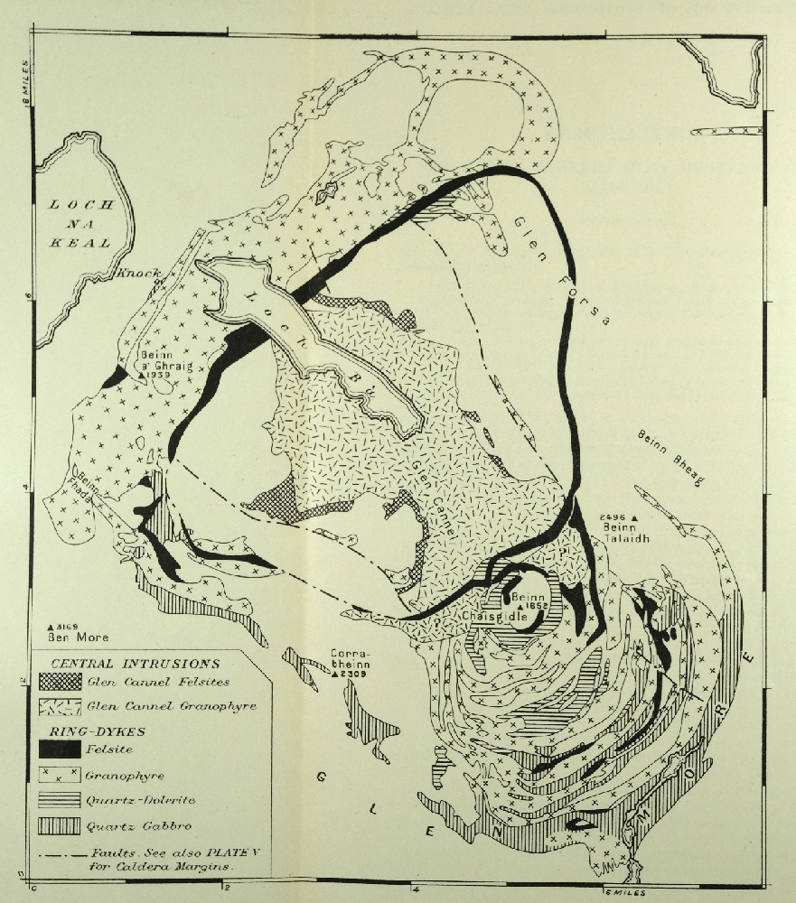
(c) Glen Forsa: Fan and eskers (Chapter 37); Killbeg Bing-Dyke (p. 343); Loch Bà Felsite Ring-Dyke and faulting of Early Basic Cone-Sheets (pp. 339, 238); Gaodhail River section of Augite-Diorite and Late Basic Cone-Sheets (Chapters 18 and 28).

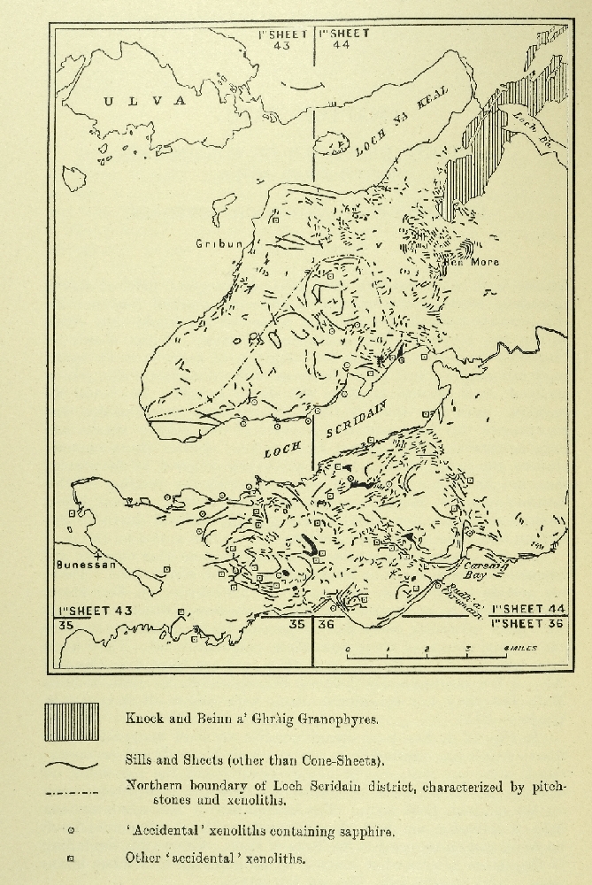
(d) Loch Bà: Knock and Beinn a' Ghràig Granophyres separated by Screen; Caps on Beinn Ghràig Granophyre; Late Basic Cone-Sheets cut by Granophyre; Loch Bà Felsite Ring-Dyke—all in Chapter 32 ( (Plate 6), etc ); Hybrids (Chapter 33); Glen Cannel Granophyre (Chapter 31).

(e) Ben More Massif: Amygdaloidal lavas of Pneumatolytic Zone both without and within Contact-Alteration Zone (pp. 128, 142, 152); Ben More Mugearite (Chapter 8); Sills (Chapter 26).

(f)  Loch na Keal, South Shore; Contrast of Lavas of Area 8 (Chapter 8), inside Pneumatolysis Limit, and those Area 2 (Chapter 6), outside same; Sills (Chapter 26); Dykes, altered within Pneumatolysis Limit (Chapter 34); Glaciated Pot-Holes (Chapter 37).

(g) Loch na Keal, North Shore: Lavas of Area 3 (Chapter VI); Dykes (Chapter 34).

(h) Sound of Mull, north-westwards Bràigh a' Choire Mhòir trachytic vent (Chapter 14): Lavas of Area 3 (Chapter 6); Dykes (Chapter 34); See also Ardnacross Trachyte of Sheet 52.

Lochaline—Village with Inn (in Morven)

(a) East and west of Loch Aline: Lavas of Area 4 (Chapter 6); Dykes (Chapter 34).

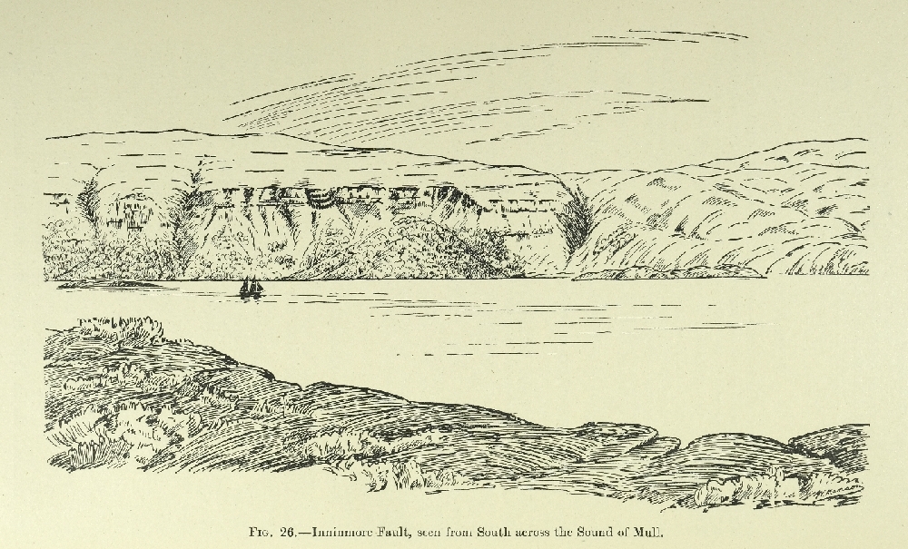
(b) West of Loch Aline: Inninmore Fault ( (Figure 26), p. 182); Inninmorite Sheet-and-Dyke-Complex (p. 293); Camptonite-Dykes (Chapter 35).

Craiguure—Hamlet with Inn.

(a) Sound of Mull, south-east to Duart Bay: Craignure Anticline and Early Acid Cone-Sheets (Chapters 13 & 19).

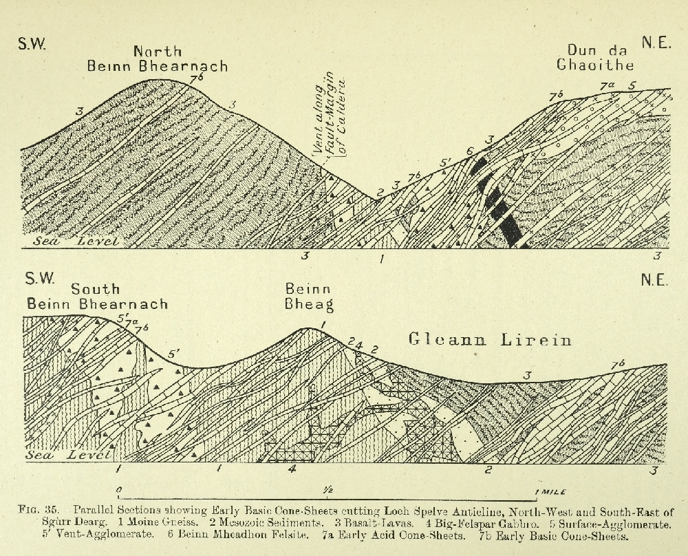
(b) Dùn da Ghaoithe Range: Big-Felspar and other Basalt-Lavas of Area 5 (Chapter 8); Agglomerates of Coire Her Syncline (Chapter 15); Early Acid and Basic Cone-Sheets (Chapters 19 & 21).

(c) Sound of Mull north-west to Garmony Point: Craignure Anticline (p. 176). Composite Cone-Sheets (pp. 223, 228).

Lochdonhead—Village

(a) North of Loch Don: Sand-Moraine in relation to Raised Beaches (p. 405).

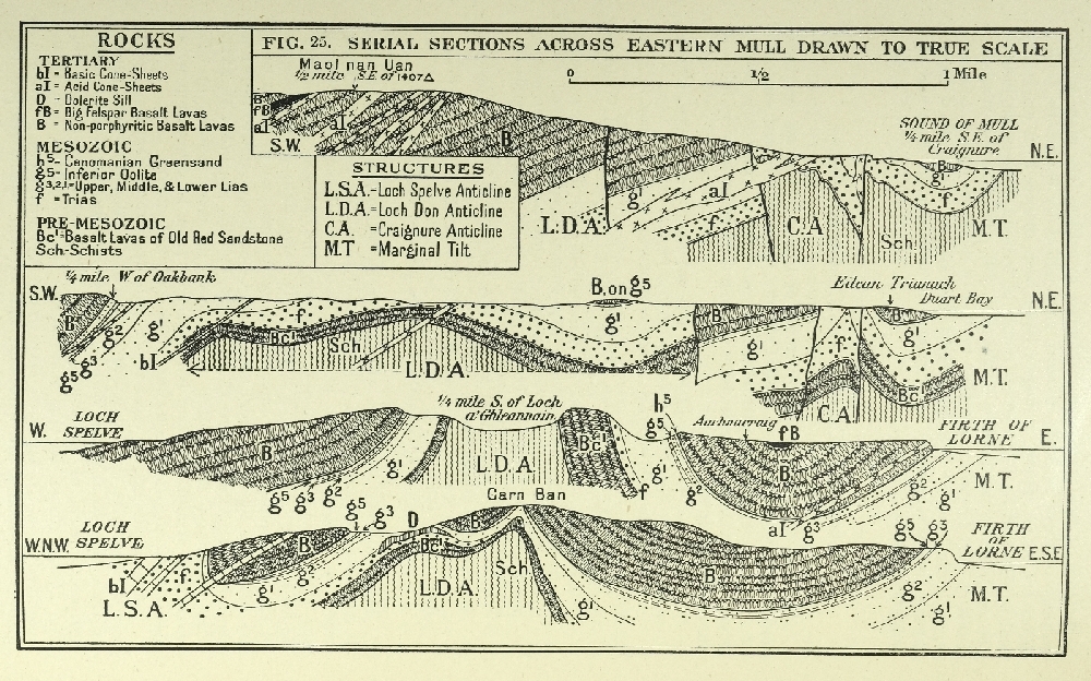
(b) Peninsula south of Loch Don: Lavas of Area 5 (Chapter 8); Marginal Tilt, Duart Bay Syncline, Loch Don Anticline, Coire Mòr Syncline, Loch Spelve Anticline ( (Plate 5), and (Figure 25), Chapter 8); relation of Cone-Sheets to Loch Don and Loch Spelve Anticlines (pp. 222, 236); Port, Donain Wrench-Fault (p. 183).

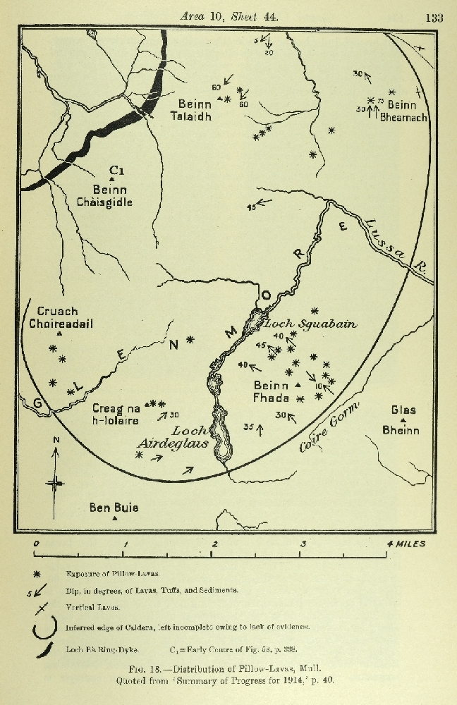
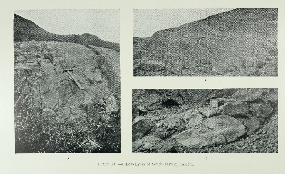
(c) Road towards and into Glen More: Roadside sections of Early Basic Cone-Sheets, west of Ardachoil (Chapter 21), and Vent-Agglomerate, opposite Gleann Sleibhte-coire (Chapter 16); Pillow-Lavas, Coire Gorm and Beinn Fhada, and beside track leading to Glen Forsa ( (Plate 4) and (Figure 18), Chapter 9).

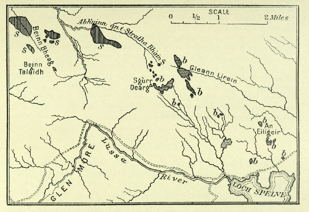
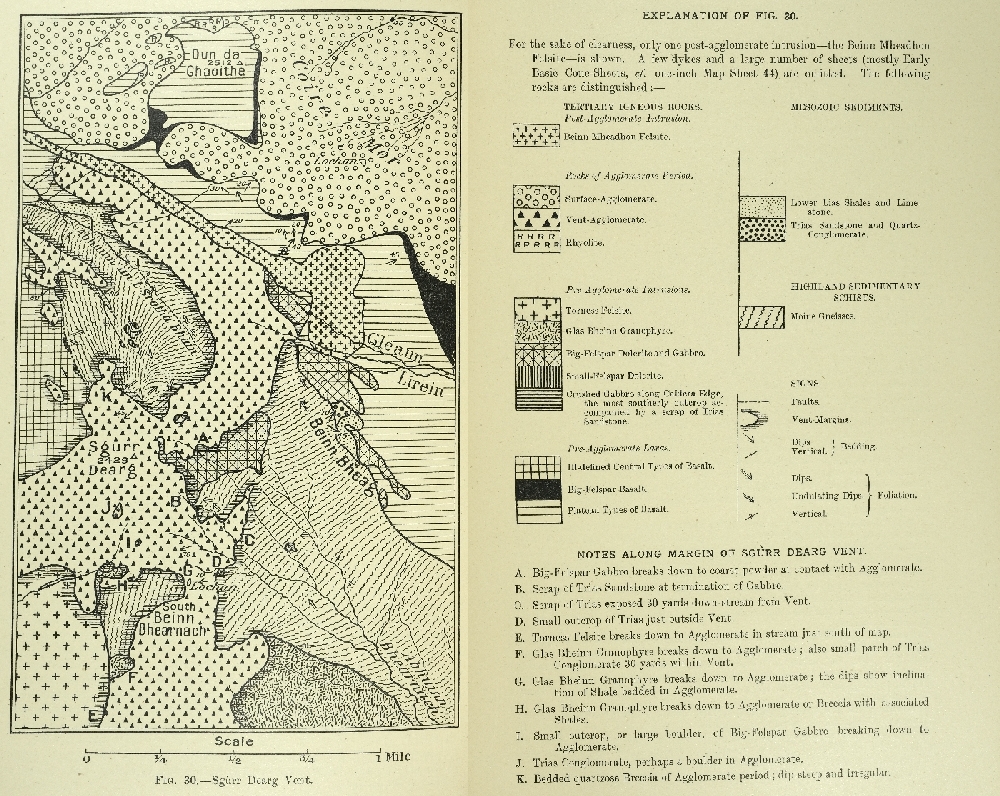
(d) Sgùrr Dearg: Big- and Small-Felspar Dolerites ( (Figure 22), Chapter 11); relations of Vent-Agglomerates to Early Gabbros, Granophyres, etc. ( (Figure 30), Chapter 16); relations of Early Basic Cone-Sheets to Loch Spelve Anticline and Vent-Agglomerates ( (Figure 35), Chapter 21).

(e) Gleann Lìrein Coire Mòr Syncline and Beinn Mheadhon Felsite ( (Figure 30) and (Figure 35), and Chapters 8, 13, 15, and 17).

Oban, Kilninver, Clachan Bridge, etc.—Plenty of accommodation (Mainland of Lorne)

Dykes of Mull Swarm (Chapter 34); Explosion-Vents on dykes (pp. 364–5); See also Staffa (Sheet 43).

Croggan—Hamlet

(a) South-east coast to Port a' Ghlinne: Lavas of Area 6 (Chapter 8); Dykes (Chapter 34); Explosion-Vents on Dykes (pp. 365–6).

(b) Inland: Gentle arcuate folds ( (Plate 5) Chapter 13).

Loch Buie—Village

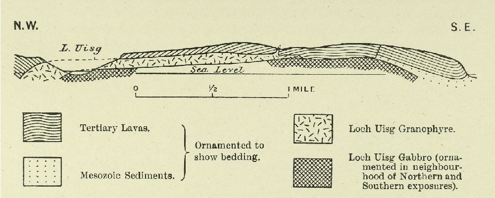
(a) South of Loch Uisg: Lava-succession in Area 6 from Plateau to Central Group (3, Chapters 6 & 8); Arcuate folds cut by Loch Uisg Granophyre ( (Figure 34), and Chapters 13 & 20); flat top and contact-altered roof of Loch Uisg Granophyre (p. 153 and Chapter 20); Loch Uisg Gabbro (Chapter 20).

(b) Kinlochspelve: Barachandroman outcrop of Surface-Agglomerate (pp. 197–8); Moraines of shelly clay (p. 406).

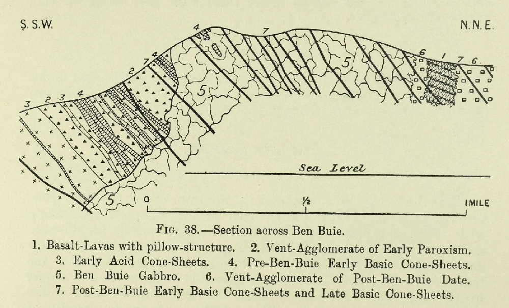
(c) North of Loch Uisg and Loch Spelve and east of Gleann a' Chaiginn Mhòir: Relation of Ben Buie Gabbro to Early Basic Cone-Sheets (Chapter 21); Agglomerate-Vents (p. 207); Glas Bheinn Granophyre and its assimilation of sandstone (Chapter 12); moraines (p. 399).

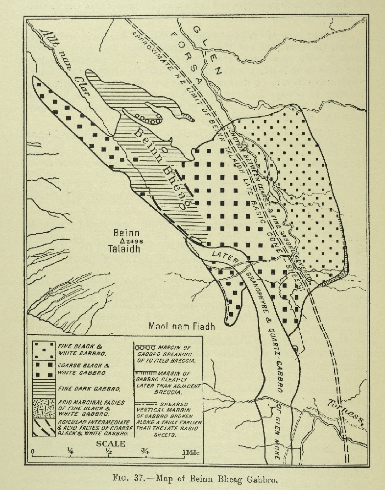
(d) North of Loch Buie: Ben Buie Gabbro ( (Figure 38), Chapter 22); dual relation of Ben Buie Gabbro to Vent-Agglomerates (pp. 199, 247); relations of Ben Buie Gabbro to Acid and Basic Cone-Sheets (pp. 222, 245); banded granulitic suite of Loch Fuaran (p. 252).

(e) West of Loch Buie: Lava-succession in Area 7 from Plateau to Central Group ( (Plate 3), Chapters 5 and 8); coast-section of Cone-Sheets (p. 239); Folds and Faults ( (Plate 5) and pp. 175, 178).

Carsaig —A few houses

Desert-Sandstone (p. 57); Lavas of Area 1 with examples of double-tier Columnar Flows (Chapter 6); intercalated Coals and Sediments (pp. 63, 64); Loch Scridain Sills with pitchstone and xenoliths, including Rudh' a' Cbromain Sill ( (Figure 42), (Figure 43), (Figure 44), (Figure 45), (Figure 46), (Figure 47), (Figure 48), Chapters 23–25); Syenite and Bostonite (Chapter 14).

Kinlochscridairt—Inn

(a) Westwards both sides of Loch Scridain: Lavas of Areas 7 and 8 (Chapter 8), inside Limit of Pneumatolysis, contrasting with those of Areas 1 and 2 (Chapter 6), outside same; Loch Scridain Sills with pitchstones and xenoliths ( (Figure 42), (Figure 43), (Figure 44), (Figure 45), (Figure 46), (Figure 47), (Figure 48), Chapters 23–25); Macculloch's and other Trees and associated Columnar Lavas (Frontispiece, and pp. 108, 113; tide must be at least half out). Dr. Heddle's tachylyte selvage (p. 265); Pre-Glacial Beach-Notch (p. 387). Most of these are more easily approached from Bunessan or Iona (Sheet 43).

(b) Ben More Massif: see Soden (e).

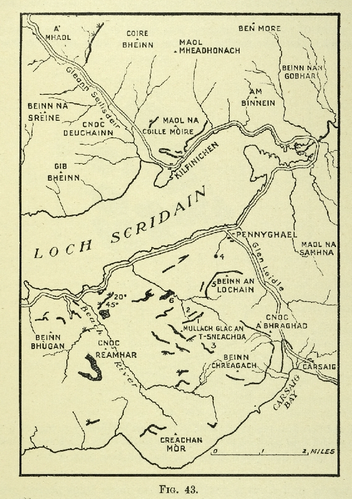
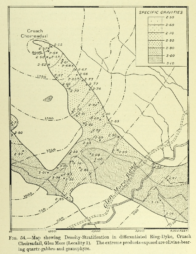
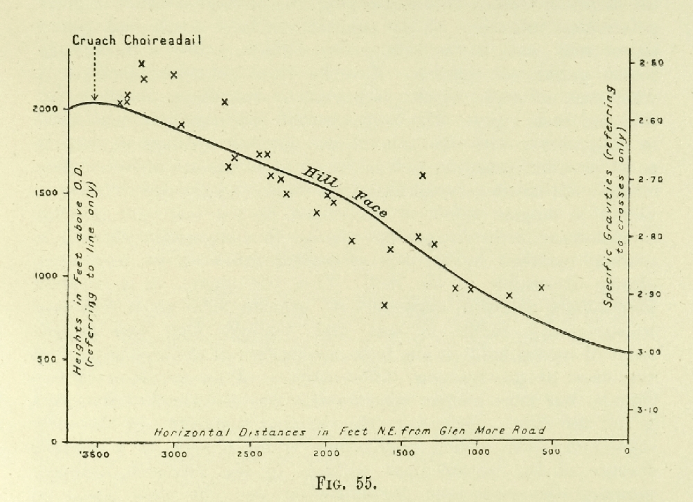
(c) Glen More road from Inn to Craig Cottage: Mugearite lava (p. 124); Plateau and Central Lavas of Areas 7 and 8 (Chapter 8); Derrynaculen Granophyre (Chapter 12); relations of Early and .Late Basic Cone-Sheets to Ben Buie, Corra-bheinn, and Glen More Gabbros (Chapters 21, 22, 28, 29). Gravitational differentiation ( (Figure 54), (Figure 55), (Figure 56), Chapter 30); Pillow-Lavas (p. 134).

(d) South-east of Inn: Bostonite (pp. 187–8). See also Loch Buie (c & d).

Glen More

A road runs along the through-valley known as Glen More connecting the north end of Loch Spelve with Kinlochscridain. There are cottages very well situated for the geology at Craig and Ishriff. It may be possible to obtain quarters, or at any rate it is easy to tent at one or other situation. The sections can also be reached by walking, cycling, or driving from Lochdonhead or Kinlochscridain.

(a) Near Craig: See Kinlochscridain (c).

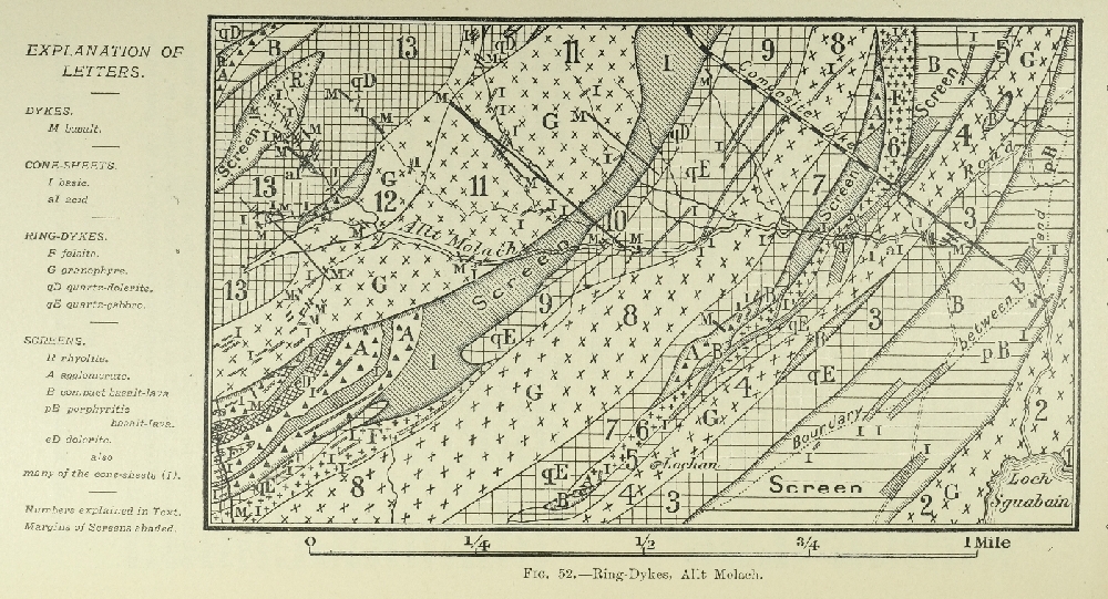
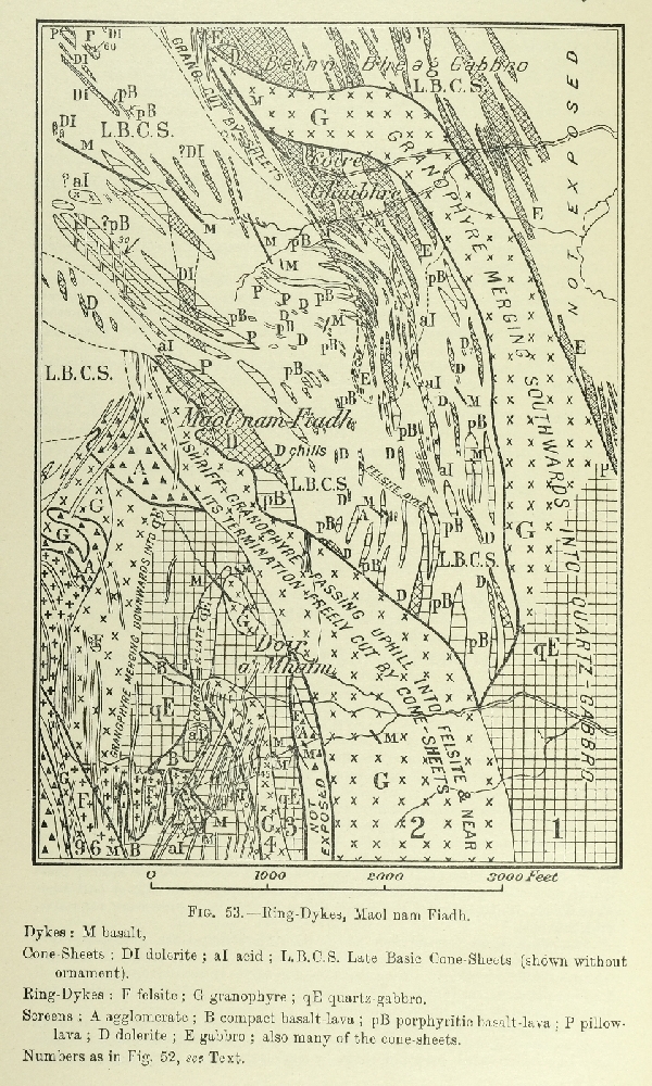
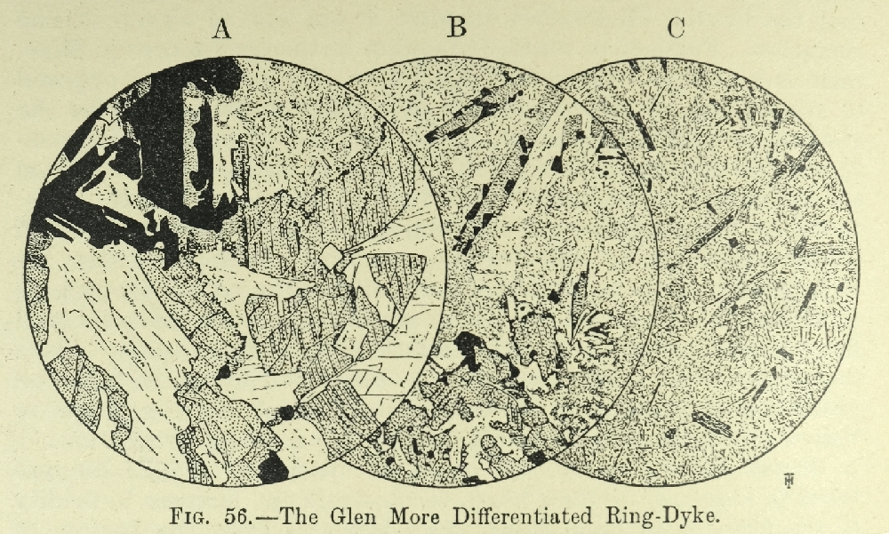
(b) Near Ishriff: Ring-Dykes of (Figure 52) and (Figure 53) (Chapter 29); Pillow-Lavas pp. 134, 312); Beinn Bheag Gabbro ( (Figure 37), Chapter 22).

Sheet 43

Bunessan—Village with Hotel

(a) North of Loch Scridain, by boat from one of the coastal cottages: see under Kinlochscridain (a).

(b) South of Loch Scridain: Ardtun Leaf-Beds (Chapters 3 and 4). Prof. Cole's tachylyte-selvage (p. 265). Loch Scridain Sills with pitchstones and xenoliths (Chapters 23–25). Lavas with double-tier columnar jointing (pp. 108, 145).

(c) South and west of village: camptonite-dykes (Chapter 36).

Iona—Village with two hotels. Visitors can reach by motor-boat exposures listed under Bunessan and Staffs.

Staffa—Uninhabited. Visited by Tourist-Steamer from Oban, by sailing-boat from Gometra, or by motor-boat from Iona (Chapter 7).

Ulva and Gometra—Islands with Inn

(a) Staffa, see above.

(b) The islands themselves: Pipe-Amygdales and Segregation-Veins in Lavas (pp. 114, 138); Preglacial Beach-Platform and Sea-Cave (pp. 388, 390).

(c) North of Loch Tuath Pipe-Amygdales and Auto-Intrusion phenomena in Lavas (pp. 113–4); Preglacial Beach-Notch (p. 388).

Gribun. —Village on main road between Salen and Kinlochscridain

Desert-Sand and Silicified Chalk (pp. 54–6). It is possible, though wearisome, to reach Macculloch's Tree, etc., listed under Kinlochscridain (a) by descending cliff near Stac Was Bun an Uisge; Sills (Chapter 23–24); Preglacial Beach-Notch, (p. 387).

Sheet 51

Dervaiy.—Village with Hotel

Lavas (Chapter 7); 'S Airde Beinn Plug (Chapter 11); Sills (Chapter 27);

Dykes (Chapter 34); Preglacial Beach-Notch (p. 388).

Sheet 52

Tobermory—Village with Hotels.

Ardnacross Trachyte-Plug (p. 186); see also Dervaig (Sheet 51).

E.B.B. (as Editor).

(Figure 18) Distribution of Pillow-Lavas, Mull. Quoted from Summary of Progress for 1914, p. 40.

(Figure 22) Map of Big-Felspar Dolerites b,and Small Felspar Dolerites s, Sgùrr Dearg District.

(Figure 25). Serial sections across Eastern Mull drawn to true scale. Rocks, Tertiary: bI = Basic Cone-Sheets aI = Acid Cone-Sheets D = Dolerite Sill fB = Big Felspar Basalt Lavas B = Non-porphyritic Basalt Lavas. Mesozoic: h5 = Ceitomanian Greensand g5 = Interior Oolite g3,2,1 = Upper, Middle.& Lower Lias  f = Trias. Pre-Mesozoic: Bc1=Basalt Lavas of Old Red Sandstone; Sch=Schists. Structures: L.S.A.=Loch Spelve Anticline. L.D.A.=Loch Don Anticline. C.A. =Craignure Anticline M.T. =Marginal Tilt.

(Figure 26) Inninmore Fault, seen from South across the Sound of Mull.

(Figure 30) Sgùrr Dearg Vent. Explanation of Figure 30. For the sake of clearness, only one post-agglomerate intrusion—the Beinn Mheadhon Felsite—is shown. A few dykes and a large number of sheets (mostly Early Basic Cone-Sheets, cf. one-inch Map Sheet 44) are omitted. Notes along margin of Sgùrr Dearg vent: A. Big-Felspar Gabbro breaks down to coarse powder at contact with Agglomerate. B. Scrap of Trias Sandstone at termination of Gabbro. C. Scrap of Trias exposed 30 yards down-stream from Vent. D. Small outcrop of Trias just outside Vent. E. Torness Felsite breaks down to Agglomerate in stream just south of map. F. Glas Bheinn Granophyre breaks down to Agglomerate; also small patch of Trias Conglomerate 30 yards within Vent. G. Glas Bheinn Granophyre breaks down to Agglomerate; the dips show inclination of Shale bedded in Agglomerate. H. Glas Bheinn Granophyre breaks down to Agglomerate or Breccia with associated Shales. I. Small outcrop, or large boulder, of Big-Felspar Gabbro breaking down to Agglomerate. J. Trias Conglomerate, perhaps a boulder in Agglomerate. K. Bedded quartzose Breccia of Agglomerate period; dip steep and irregular.

(Figure 34) Section showing Loch Uisg Granophyre cutting folded lavas.

(Figure 35) Parallel Sections showing Early Basic Cone-Sheets cutting Loch Spelve Anticline, North-West and South-East of Sgùrr Dearg. 1 Moine Gneiss. 2 Mesozoic Sediments. 3 Basalt-Lavas. 4 Big-Felspar Gabbro. 5 Surface-Agglomerate. 5' Vent-Agglomerate. 6 Beinn Mheadhon Felsite. 7a Early Acid Cone-Sheets. 7b Early Basic Cone-Sheets.

(Figure 37) Map of Beinn Bheag Gabbro.

(Figure 38) Section across Ben Buie. 1. Basalt-Lavas with pillow-structure. 2. Vent-Agglomerate of Early Paroxism. 3. Early Acid Cone-Sheets. 4. Pre-Ben-Buie Early Basic Cone-Sheets. 5. Ben Buie Gabbro. 6. Vent-Agglomerate of Post-Ben-Buie Date. 7. Post-Ben-Buie Early Basic Cone-Sheets and Late Basic Cone-Sheets.

(Figure 42) Map of South-West Mull, showing distribution of Sills and Sheets other than Cone-Sheets.

(Figure 43) Map of some of the occurrences of Pitchstone in Loch Scridain district. Quoted from Quart. Journ. Geol. Soc., vol. lxai., 1916, p. 206.

(Figure 44) Sheath and-Core Structure as exhibited in the Sheet numbered 1 in Figure 43, p. 261. The shaded areas represent pitchstone. The height of the crag is about 5 feet. Quoted from Quart. Journ. Geol. Soc., vol. lxxi, 1916, p. 211.

(Figure 45) Section at Rudh' a' Chromain across xenolithic composite sheet, showing external chilled margins against sandstone (SST) and bostonite (BOST). Quoted with minor alterations from Quart. Journ. Geol. Soc., vol. lxxviii, 1922, p. 234.

(Figure 46) Aluminous Xenoliths. A. [(S16612) [NM 522 203] [NM 522 203]] ×15. Large idiomorphic crystals of sapphire with associated greenish. brown spinel, enclosed by coarsely crystalline anorthite, with a little residual brown glass. B. [(S18493) [NM 5342 2220]] ×15. Idiomorphic crystals of rose-pink spinel, and a large crystal of cordierite in a matrix of oligoclase felspar, an opaque spinellid and residual glass. C. [(S18001A)] ×15. The section shows a large irregular crystal of cordierite (centre) studded with brown spinel, also idiomorphic highly pleochroic rose-pink sillimanite (right and left) enclosed in a semi-opaque glassy matrix.

(Figure 47) Leidleites. A from glassy centre and B from stony margin of sheet numbered 2 in Figure 43, p. 261. A. [(S17243) [NM 5018 2359]1×20. Narrow laths and skeletal growths of plagioclase, and blades of augite (and some hypersthene) in a matrix of brown glass. B. [(S17244) [NM 5018 2359]] ×20. Laths of plagioclase, and elongated crystals of augite (and some hypersthene), in a matrix of felspar-microliths, augite-granules, and interstitial glass. There is an approach to the intersertal structure of the tholeiites. Quoted from Quart, Journ. Geol. Soc., vol. lxxi., 1916, p. 208.

(Figure 48) Inninmorites. A and B from localities 5 and 4 respectively in Figure 43, p. 261. A. [(S15990) [NM 5176 2404]] ×20. Small Phenocrysts of basic plagioclase and rounded crystals of uniaxial augite in a ground-mass of augite- and felspar-microliths, with interstitial glass. B. [(S15989) [NM 5077 2552]] ×20. Small phenocrysts of basic plagioclase and uniaxial augite in a matrix of brown glass. The glass is variable in colour, and locally almost opaque. Quoted from Quart. Journ. Geol. Soc., vol. lxxi., 1916, p. 208.

(Figure 52) Ring Dykes, Allt Melach.

(Figure 53) Ring-Dykes, Maol nam. Fiadh. Dykes: M basalt, Cone-Sheets: DI dolerite; aI acid; L.B.C.S. Late Basic Cone-Sheets (shown without ornament). Ring-Dykes: F felsite; G granophyre; qE quartz-gabbro. Screens: A agglomerate; B compact basalt-lava; pB porphyritic basalt-lava; P pillow-lava; D dolerite; E gabbro; also many of the cone-sheets. Numbers as in Figure 52, see Text.

(Figure 54) Map showing Density-Stratification in differentiated Ring-Dyke, Cruach Choireadail, Glen More (Locality 1). The extreme products exposed are olivine-bearing quartz-gabbro and granophyre.

(Figure 55) Graph showing relation of Specific Gravity to Altitude in gravitationally differentiated Ring-Dyke, Cruach Choireadail, Glen More.

(Figure 56) The Glen More Differentiated Ring-Dyke. A. [(S17636) [NM 5968 2968]] ×15. Lower Basic Portion. Quartz-gabbro. The rock is composed of labradorite, ophitic augite and large plates of ilmenite, with a variable amount of finely crystalline acid mesostasis (top). Where in contact with the acid residuum, the augite shows signs of resorption. Movement of the mass after partial consolidation has frequently resulted in the bending and breaking of crystals—note the curved cleavage-traces in the large crystal of augite.Fig. 56 B. [(S17632) [NM 5965 3014]] ×15. Intermediate Portion. The figure shows a rock in which there is an increased proportion of acid mesostatic matter with characteristic acicular crystallization of its components. It has developed columnar crystals of augite (top) with their usual association of magnetite, and it encloses small patches of more doleritic material (bottom) which show signs of resorption and of being out of equilibrium with their surroundings. C. [(S17626) [NM 5952 3042]] x 15. Higher Acid Portion. Acicular type of crystallization is a characteristic feature. The rock is composed of elongated crystals of greenish hornblende, pseudomorphous after augite, in a feathery base of alkali-felspar and quartz, frequently in micrographic relationship to each other.

(Plate 3) Map showing the distribution of lava-types and the limit of pneumatolysis

(Plate 4) Pillow-lavas of central Mull

(Plate 5) Map showing calderas, major intrusions, and folds

(Plate 6) Map showing ring-dykes