Courtesy British Geological Survey. Copyright: HMSO. List of Systematic Series and Geological Photographs: UKRI. Peach, B.N., Horne, J. Gunn, W, Clough, C.T., Hinxman, L.W. 1907. The geological structure of the North-West Highlands of Scotland. Glasgow: HMSO [for Geological Survey of Great Britain].

The geological structure of the North-West Highlands of Scotland

By B. N. Peach, Ll.D., F.R.S.; John Horne, Ll.D., F.R.S.; The Late W. Gunn; C. T. Clough, M.A., F.G.S.; and L. W. Hinxman, B.A. with petrological chapters and notes By J. J. H. Teall, M.A., D.Sc., F.R.S.

Edited By Sir Archibald Geikie, D.C.L., Sec.R.S.

Memoirs of the Geological Survey of Great Britain.

Published By Order Of The Lords Commissioners Of His Majesty's Treasury, Glasgow: Printed For His Majesty's Stationery Office By James Hedderwick & Sons Ltd.. At "The Citizen" Press. St. Vincent Place. and to be purchased from W. & A. K. Johnston, Ltd., 2 St. Andrew Square, Edinburgh; E. Stanford, 12. 13, And 14 Long Acre, London; Hodges, Figgis & Co., Ltd., Grafton Street, Dublin; Front any Agent for the sale of Ordnance Survey Maps; or through any Bookseller from the Ordnance Survey Office, Southampton. 1907.

Price, Ten Shillings and Sixpence.

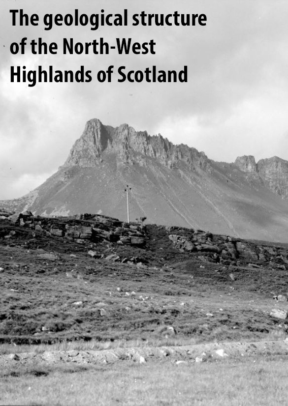
(Front cover) [Supplied for GeoGuide] Stac Pollaidh (Stac Polly)

(Title page) The geological structure of the North-West Highlands of Scotland.

(Frontispiece) As Plate 34 Overfolding of Cambrian quartzites above Ben More thrust-plane; Na Tuadhan, north of Ben More, Assynt, Sutherlandshire.

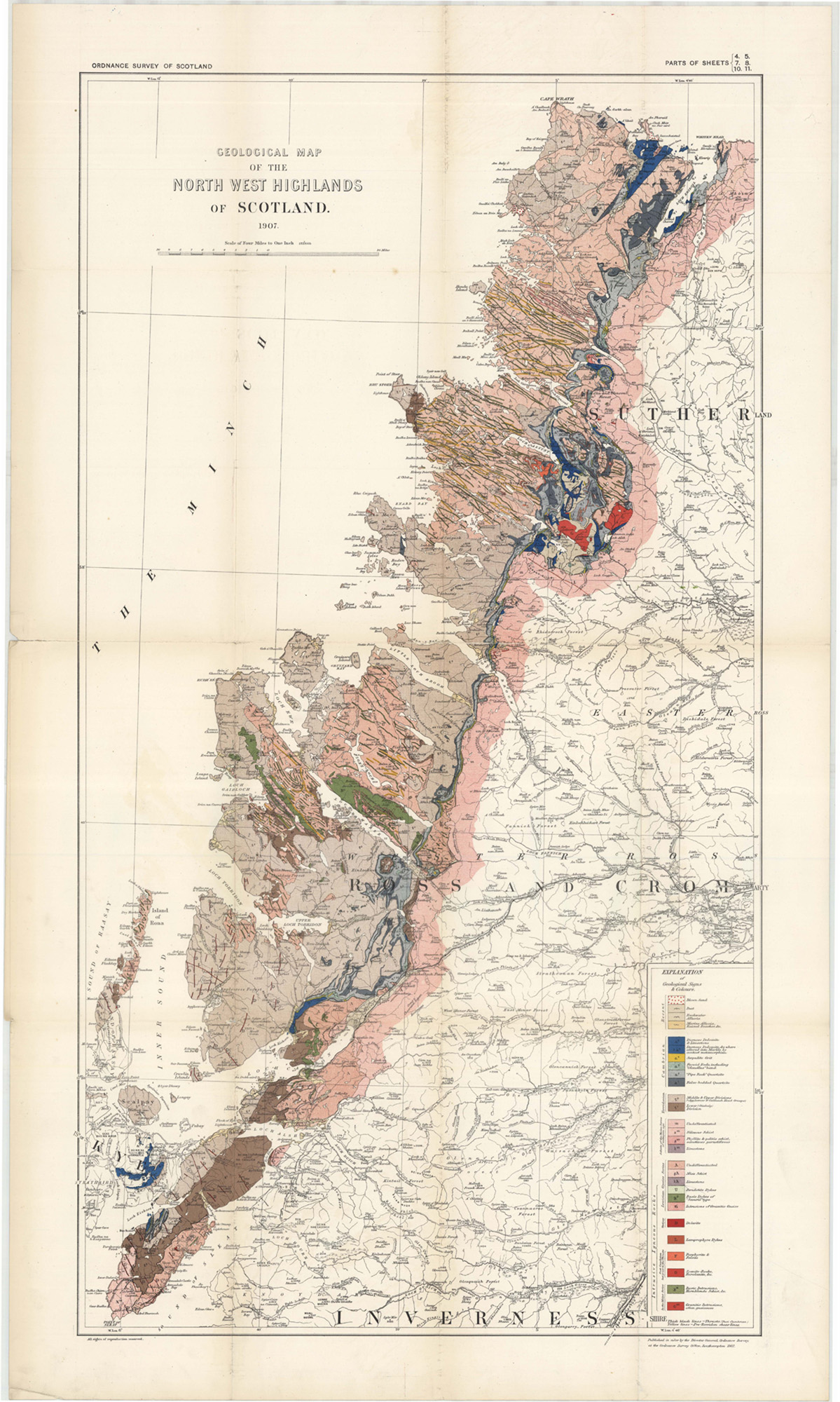
(Map 1) Geological map of the North West Highlands of Scotland. 1907. Scale of Four Miles to One Inch.

Preface

When the Geological Survey, in its northward progress from the midland counties of Scotland, entered upon the examination of the Southern and Eastern Highlands, many difficulties were encountered in the attempt to ascertain and map the true order of succession of the rocks of that part of the country, and the details of their tectonic arrangement. The further the field-work was carried into the region of the crystalline schists the problems which these schists presented seemed to increase in number, and the prospect of being able to solve them appeared to grow more distant. Accordingly I at last came to the conclusion that as a recognisable succession of formations had long been known to exist in the North-West Highlands, more satisfactory progress would not improbably be made if a portion of the surveying staff of the service were transferred to that region.

In the hope, therefore, that a detailed study of Western Sutherland and Ross would throw light on the geological structure of the rest of the Highlands, a beginning was made in the year 1883 in the district of Durness by Messrs. Peach and Horne. The history of the previous investigation of the geology of the North-West Highlands will be found fully narrated in Chapter 2 of the present volume. It will be sufficient to remark here that when the Geological Survey entered upon the detailed examination of the ground it was in the expectation that the stratigraphical sequence which had been worked out by Murchison, from the fundamental gneiss up into the "gneissose flagstones" or "Eastern schists", would be established by more minute study. But this anticipation was soon dispelled. The structure of that northwestern portion of Scotland was found to be infinitely more complex than had been supposed. In particular the "Eastern schists" which Murchison believed to lie conformably upon the fossiliferous Durness limestones were found to have been pushed into their present position by gigantic dislocations of the terrestrial crust. Thus what had been assumed to be a conformable sequence from the older Palaeozoic limestones into an overlying series of schists proved to be entirely deceptive.

In these circumstances no fresh light could, in the meantime, be expected to be thrown on the problems of the structure and age of the crystalline rocks of the Highlands by prosecuting the mapping eastward into the great region of the gneissose flagstones, for the very same difficulties there presented themselves which had been found insuperable in the southern and eastern parts of the Highlands. But the detailed examination of the north of Sutherland had brought to light some types of tectonic structure of a kind and on a scale such as had never before been met with in any portion of the British Isles. It was discovered that by a complicated series of reversed faults, combined with stupendous horizontal thrusts, the rocks had been pushed over each other, slice after slice, huge sheets of the very oldest masses having been torn up and driven westward for miles so as to rest now upon the younger groups. Fortunately, owing to the marked contrast in lithological characters between the three great series of rocks — the grey or pink fundamental gneiss, the red Torridon sandstone, and the white quartzites with the limestones and dolomites — it was possible to trace the severed portions of these several formations, even through extremely complicated structures. Having. regard therefore to the ultimate solution of the Highland problems which had hitherto baffled us, I deemed that our wisest course would be to follow southward the band of territory in which these novel tectonic features had been encountered and to map it thoroughly to its extreme limits. By unravelling the complications of that piece of ground, and watching the variations in their development from district to district, it might eventually be possible to obtain a clue to the origin, sequence, and structure of the crystalline rocks of the Central Highlands.

As the mapping extended southwards it was found that the new tectonic types were developed in a strip of country which stretches along the west of the counties of Sutherland and Ross from the coast near Cape Wrath for more than a hundred miles to the most southerly promontory of the Isle of Skye. This tract of disturbed ground, or "belt of complication", as it came to be called, is bounded on the east by the most easterly of the great thrust-planes on which the gneissose flagstones, or "Moine schists", have been driven. The mapping was mainly confined to the ground between the outcrop of that thrust-plane and the western coast-line, though here and there a broader tract of the Eastern schists was surveyed.

After five years the work had stretched across the district ofAssynt, where the new tectonic types were found to be admirably developed. Enough of information had now been collected regardingthe details of these structural features to warrant the publication of a preliminary account of the results of the survey. The officers of the staff by whom the area had been surveyed, Messrs. Peach, Horne, Gunn, Clough, Hinxman, and Cadell, were instructed to draw up a Report on the subject, which, with numerous illustrative sections and diagrams, was published in the "Quarterly Journal of the Geological Society" for 1888. In subsequent years further statements regarding the progress of the mapping appeared in the "Annual Reports" and "Summaries of Progress" of the Geological Survey.

The maps of the "belt of complication" were completed in 1897. In the spring of the following year I held a conference of all the members of the Survey who had shared in the field-work. With their co-operation a detailed scheme was drawn up for the preparation of a descriptive Memoir on the Geology of the North-West Highlands. Each geologist was to give an account of that portion of the ground which he had himself surveyed. The limits of space to be allowed to each section of the book were as definitely laid down as seemed practicable, and it was anticipated that in the .course of not more than three or four years the Memoir would be entirely written and ready for the printer. When, however, early in 1901, after forty-six years in the service, I retired from the direction of the Geological Survey, the Memoir was still unfinished. As I had had charge of the mapping from its commencement, and of the Memoir which was in progress, I was asked by the Board of Education to undertake the editing of the work when it should be completed. From various causes of delay, which need not here be specified, the manuscript only came at last into my hands during the summer of 1906.

Some geologists find literary labour more irksome and arduous than field-work, and would rather survey many square miles of complicated ground than write a few pages descriptive of them. To others, again, the difficulty lies in deciding what they shall exclude from the report of their mapping. Amidst a crowd of details, all of which have their own interest and importance in the eyes of the surveyor who has patiently gathered them, perhaps with r small expenditure of time and toil, in a mountainous country and a tempestuous climate, it is not always an easy or a grateful diaty to have to determine which shall be omitted from what is intended to be a general and perspicuous summary of the geology -rthe ground that has been examined. Hence, while the fieldwork may be of equal excellence from both types of observers, the descriptive account of it may be somewhat meagre in the one case and correspondingly redundant in the other. It is obviously hardly possible for an editor, even when fully conversant with the subject, to secure among the essays of variously gifted contributors that degree of uniformity of treatment which he might desire. Considerable excision and condensation were found to be absolutely necessary in the manuscript of the present volume; and perhaps some readers may wish that these alterations had been carried still further. But I trust that no one who shall take the book with him to the ground for the purpose of mastering the structure of what will always be regarded as one of the most instructive of geological regions, will find the superabundance of local details a hindrance.

It may be claimed that the present volume, based upon Ordnance Survey maps on the large scale of six inches to a mile (1/10650), contains the first detailed account of the structure, distribution, and petrography of the whole of the Lewisian Gneiss and Torridonian Sandstone of the mainland of Scotland west of the Moine thrust, and that it thus makes an important fresh contribution to our knowledge of the pre-Cambrian rocks of Britain. It likewise records the results of an exhaustive examination of the rocks and fossils of the Cambrian formations of the same region, and in particular shows the distribution and organic contents of the Olenellus-zone which the Geological Survey has detected and traced there. But undoubtedly the feature which will give the volume its greatest interest and novelty in the eyes of geologists is the full description and illustration which it contains of the remarkable tectonic structures, the discovery of which has made the northwest of Scotland a classic region for the study of some of the more stupendous kinds of movement by which the crust of the earth has been affected.

While each of the geologists engaged in the survey of the region has contributed an account of the ground which he has himself surveyed, Dr. Horne has also supplied the introductory chapters. The petrographical portions are the work of my successor, Dr. Teall. In the early stages of the field-work some Lewisian rocks were examined and reported on by Dr. F. H. Hatch, while towards the close of the mapping a few rocks were submitted to Dr. J. S. Flett. Dr. Peach, now retired from the service, has furnished the palaeontological discussions and descriptions, and to his skilful and artistic pencil the reader is also indebted for the diagrams illustrative of the tectonic structure of the districts of Eireboll, Assynt, Loch Maree, and Loch Carron, which form one of the most important features of the volume. Certain portions of the "belt of complication" were mapped by Mr. H. M. Cadell, Mr. E. Greenly and Mr. A. Harker, who supplied notes of their work, which have been incorporated in the Memoir. The chemical analyses have been chiefly made by Dr. Pollard; a few have been supplied by Mr. Hort Player, Dr. Teall, and Mr. Barrow. The collecting of the rock-specimens on which the petrographical studies have been mainly based, and of the fossils which have formed the groundwork of the palwontological section, has been done by Mr. Arthur Macconochie, to whose trained eyes the discovery of the Olenellus zone is due. The photographs of landscapes and portions of rock-scenery from which plates have been made were taken by Mr. Robert Lunn. The photographs of microscopic rock-structures from which the series of petrographical plates was prepared were taken by Dr. Teall. The Bibliography in the Appendix was compiled by Mr. David Tait.

Arch. Geikie, late Director-General of the Geological Survey. Shepherd's Down, Haslemere, 29th June, 1907.

2024 note: Cited thin sections are linked to the photomicrographs in BGS Britrocks. Many more are available, for these see the BGS Britrocks or the GeoIndex

Contents

Chapter 1 Introduction and general section

Chapter 2 Previous literature

Part 1 Lewisian Gneiss

Chapter 3 Section 1 General account of the gneiss.

Chief petrographical characters, distribution, and structure

Chapter 4 Section 2 Petrography of the Lewisian Gneiss

A. The Fundamental Complex

Detailed account of the petrographical characters of the Complex

Chapter 5 Architectural features of the Complex

Chapter 6 B. Rocks of presumably Sedimentary origin in the Lewisian Gneiss

Mica-schists, Graphitic-schists, Quartz-schists Calcareous Rocks

Chapter 7 C. Pre-Torridonian Intrusive Rocks associated with the Lewisian Gneiss

Ultrabasic Dykes, Basic Dykes and Sills, Microcline-mica Dykes, · Biotite-diorite Dykes, &c.

Section 3 Special descriptions of areas

Chapter 8 Cape Wrath to Loch Laxford

Chapter 9 Loch Laxford to Kylesku

Chapter 10 Kylesku to Loch Broom

Chapter 11 Gruinard District

Chapter 12 Loch Maree and Gairloch

Chapter 13 Loch Torridon

Chapter 14 Loch Carron and Skye

Part 2 Torridonian

Chapter 15.-Section 1 General description and general account of the Torridonian

Chapter 16 Section 2 Petrography

Chapter 16 Section 3 Special descriptions of areas

Chapter 17 Cape Wrath to Loch Lurgan, including Stoer and Suilven Areas

Chapter 18 Coigach to Loch Maree

Chapter 19 Loch Maree to Kishorn and Raasay, North Applecross, and Crowlin

Chapter 20 Kishorn to Loch Alsh

Chapter 21 Skye

Part 3 Cambrian

Chapter 22 Section 1 General distribution and account of the system

Chapter23 Section 2 Palaeontology;

Section 3 Special descriptions of areas

Chapter 24 Durness, Eireboll to Loch More

Chapter 25 Loch More to Strath Kanaird

Chapter 26 Strath Kanaird to Strath na Sheallag

Chapter 27 Strath na Sheallag to Kishorn

Chapter 28 Skye

Section 4 Post — Cambrian igneous rocks

Chapter 29 Their distribution and horizons

Chapter 30 Their petrography

Chapter 31 Section 5 Contact metamorphism of the Durness dolomites and limestones

Part 4 Post-Cambrian movements

Chapter 32 Section 1 General description of the system of movements and account of H. M. Cadell's experiments Section 2 Detailed descriptions of areas

Chapter 33 Eireboll to Loch More

Chapter 34 Loch More to Loch Glencoul

Chapter 35 Loch Glencoul to Knockan

Chapter 36 Elphin to Strath Kanaird; Strath Kanaird to Strath na Sheallag

Chapter 37 Strath na Sheallag to Loch Maree; Loch Maree to Achnashellach

Chapter 38 Achnashellach to Kishorn; Kishorn to Loch Alsh

Chapter 39 Skye

Part 5 Eastern Schists.

Chapter 40 Section 1 General Description. Section 2 Detailed descriptions

Chapter 41 Eireboll to Loch More; Loch More to Loch Glencoul and Strath Kanaird; Strath Kanaird to Strath na Sheallag

Chapter 42 Strath na Sheallag to Loch Alsh; Skye

Appendix1 Palaeontological

Appendix 2 Chemical

Appendix 3 Bibliographical

List of figures in text

(Figure 1) Granite-gneiss cutting early banding of au older gneiss

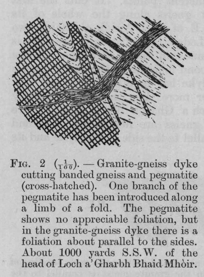
(Figure 2) Granite-gneiss dyke.

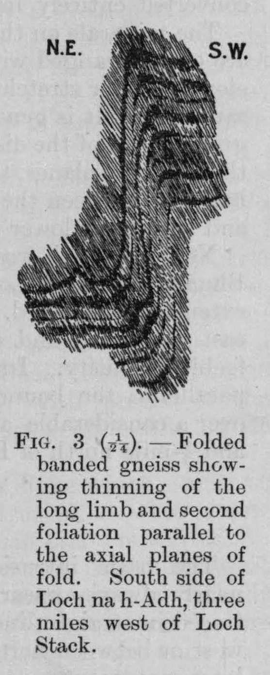
(Figure 3) Folded banded gneiss

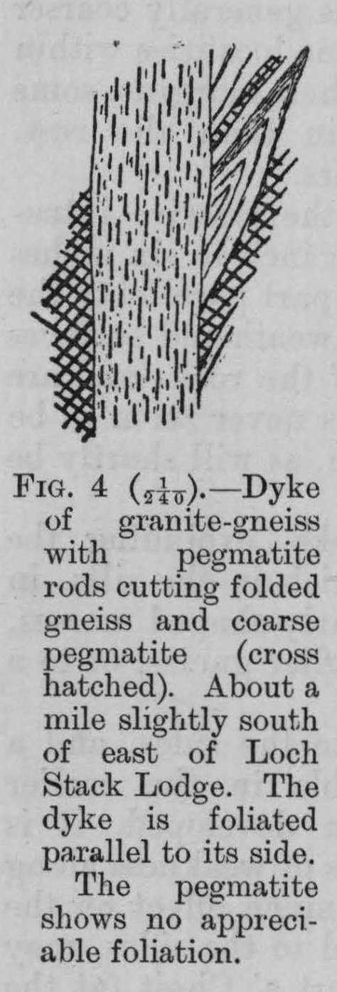
(Figure 4) Dyke of granite-gneiss with pegmatite-rods

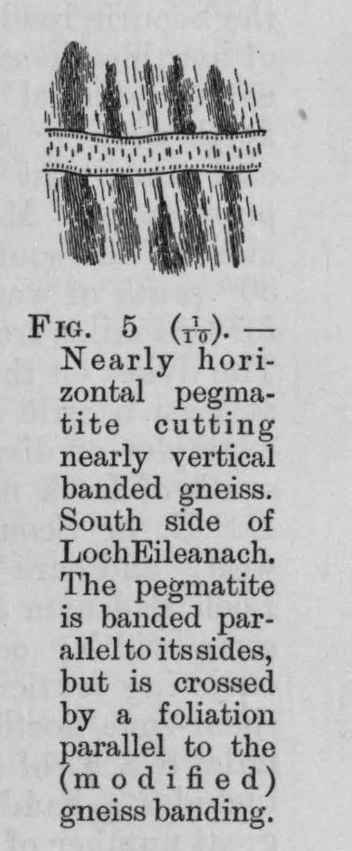
(Figure 5) Pegmatite cutting vertical banded gneiss

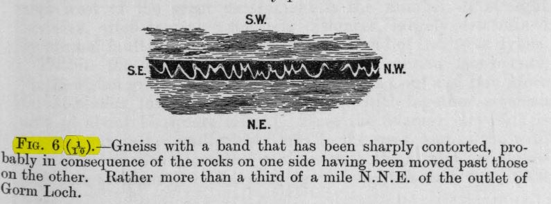
(Figure 6) Gneiss with sharply contorted band

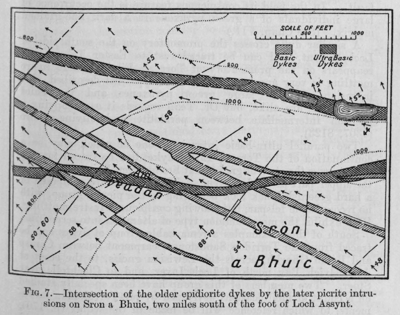
(Figure 7) Intersection of epidiorite dykes by picrite dykes-Sron a Bhuic

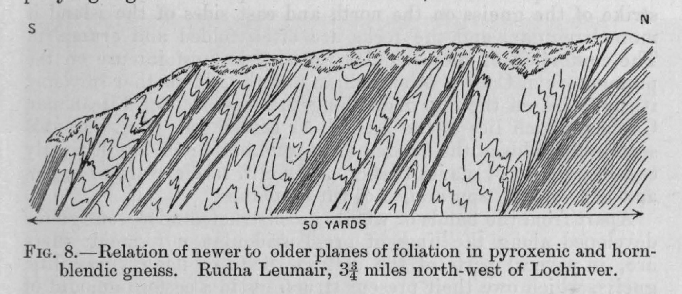
(Figure 8) Newer and older planes of foliation — Rudha Leumair

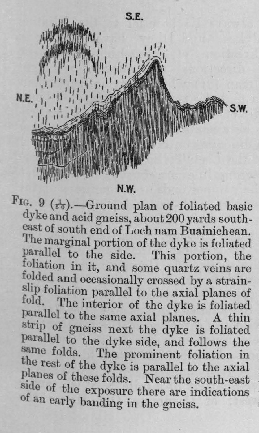
(Figure 9) Folded and foliated dyke

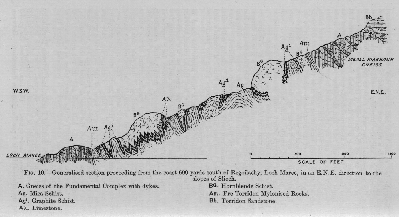
(Figure 10) Section from Loch Maree to N.E.

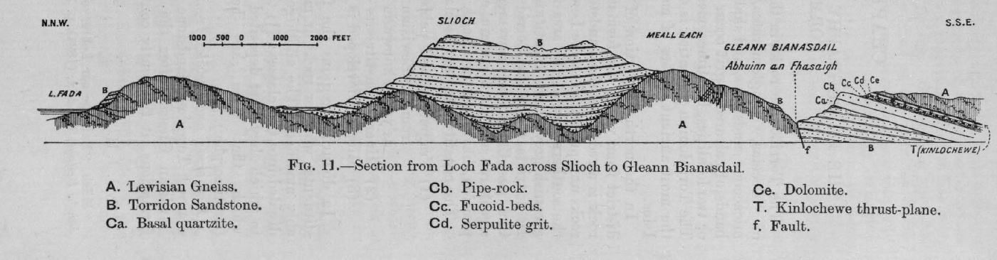
(Figure 11) Section through Slioch

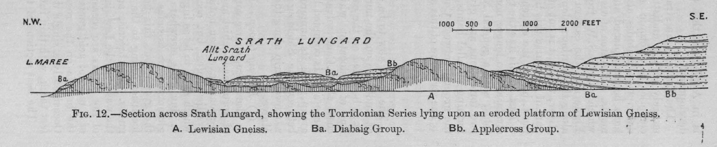
(Figure 12) Section across Srath Lungard

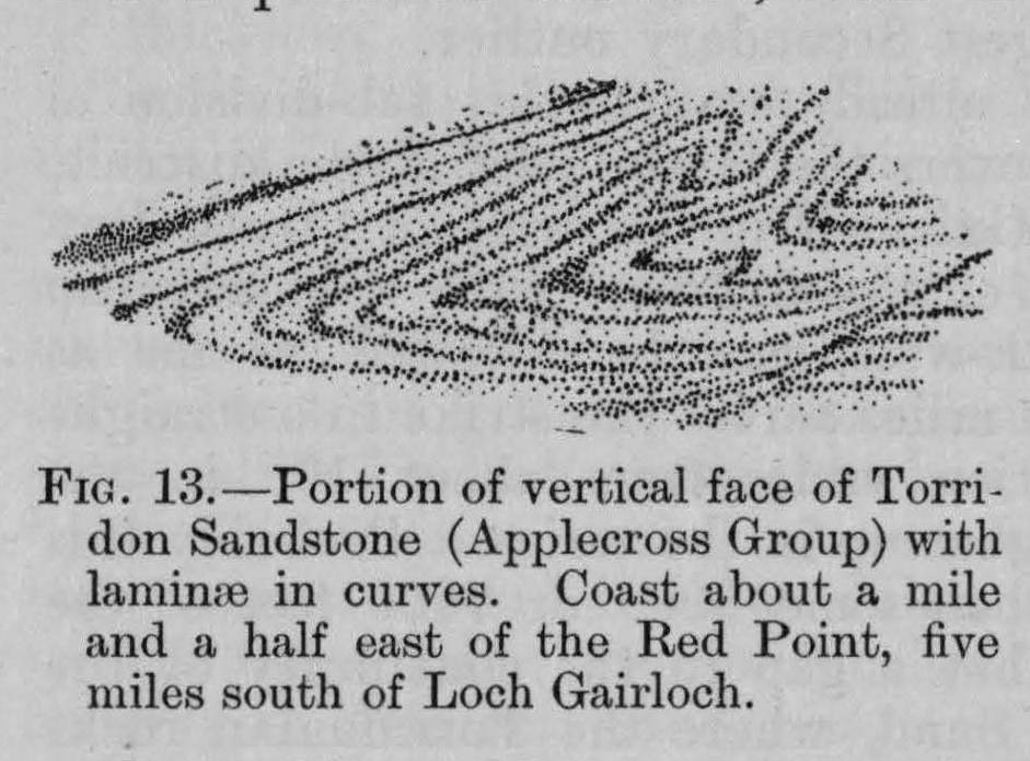
(Figure 13) Curved laminae in Applecross sandstone

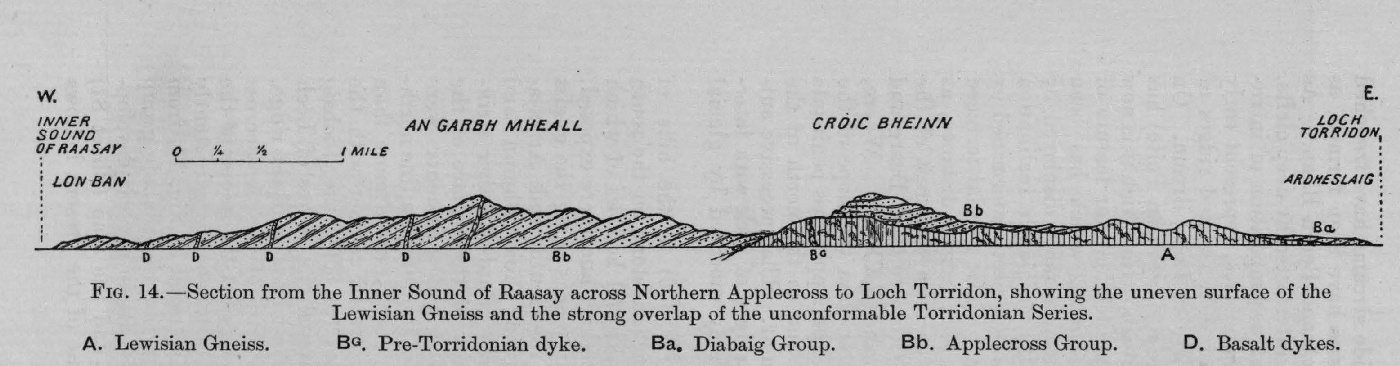
(Figure 14) Section from Inner Sound of Raasay to Loch Torridon

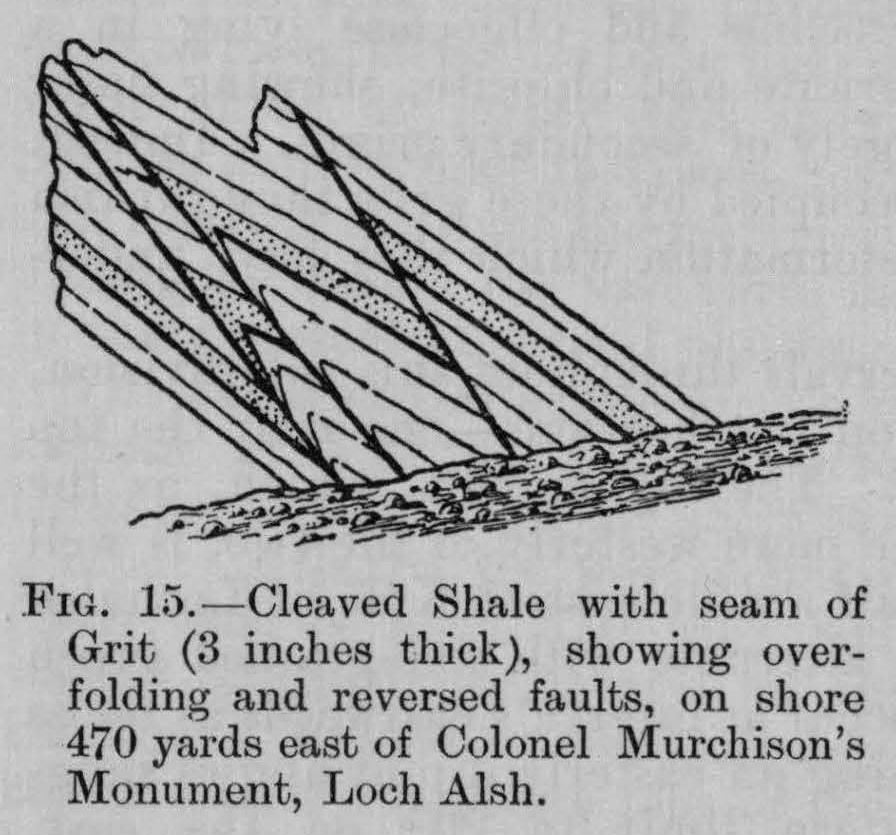
(Figure 15) Cleaved shale and seam of grit with overfolding and faults — Col. Murchison's Monument, Loch Alsh

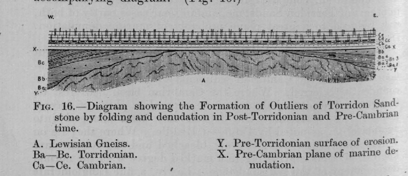
(Figure 16) Diagram showing formation of outliers of Torridon sandstone by folding and denudation

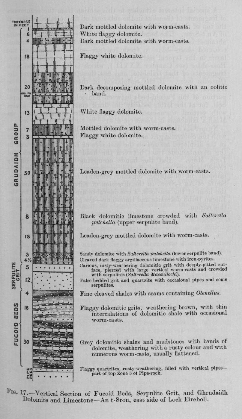
(Figure 17) Section of Ghrudaidh dolomite, serpulite-grit, and fucoid-beds — Loch Eireboll

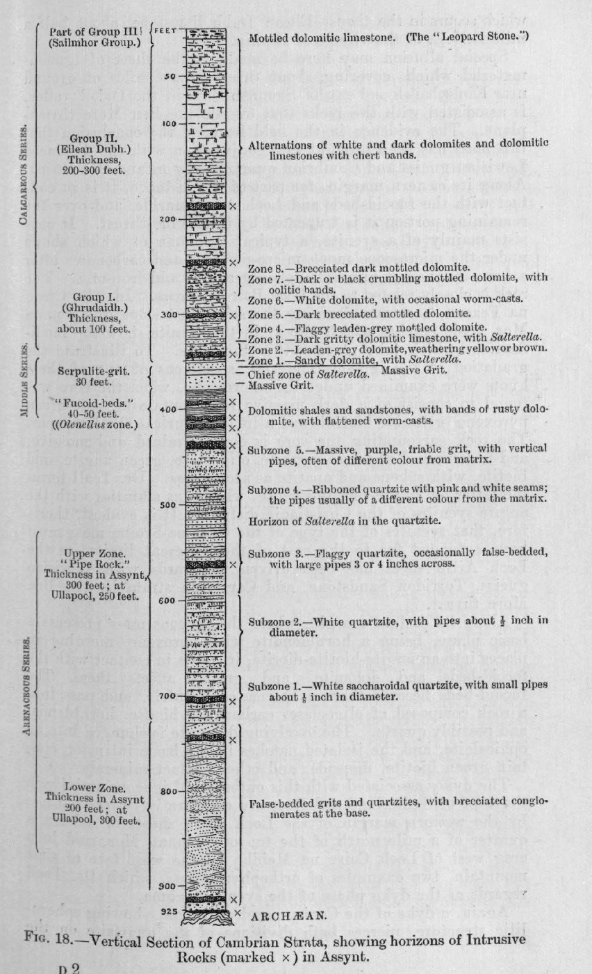
(Figure 18) Vertical section of Cambrian strata showing igneous horizons

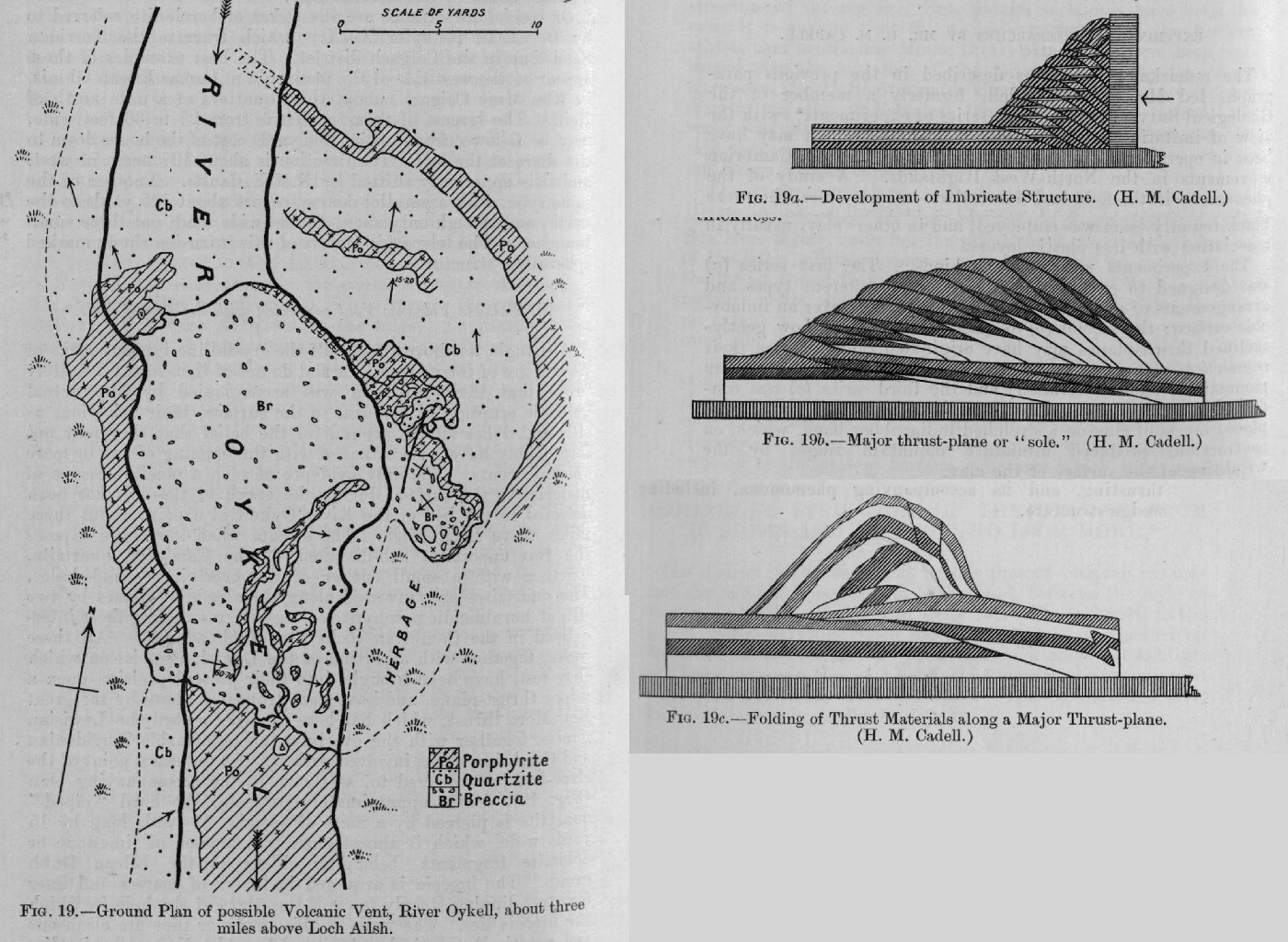
(Figure 19) Ground plan of probable volcanic vent — Bed of River Oykell

(Figure 19)a Development of imbricate structure (H. M. Cadell)

(Figure 19)b Major thrust-plane or "sole" (H. M. Cadell)

(Figure 19)c Folding of thrust materials along a major thrust- plane or "sole" (H. M. Cadell)

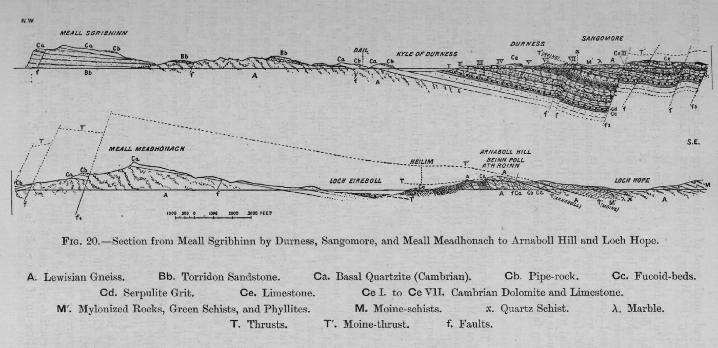
(Figure 20) Section from Meall Sgribhinn across Durness basin to Loch Hope

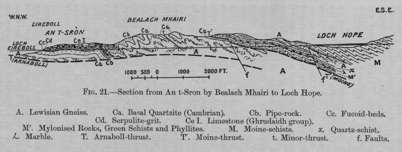
(Figure 21) Section across Bealach Mhairi to Loch Hope

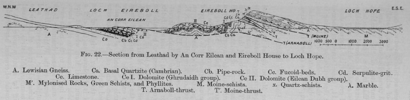
(Figure 22) Seetion through Eireboll House to Loch Hope

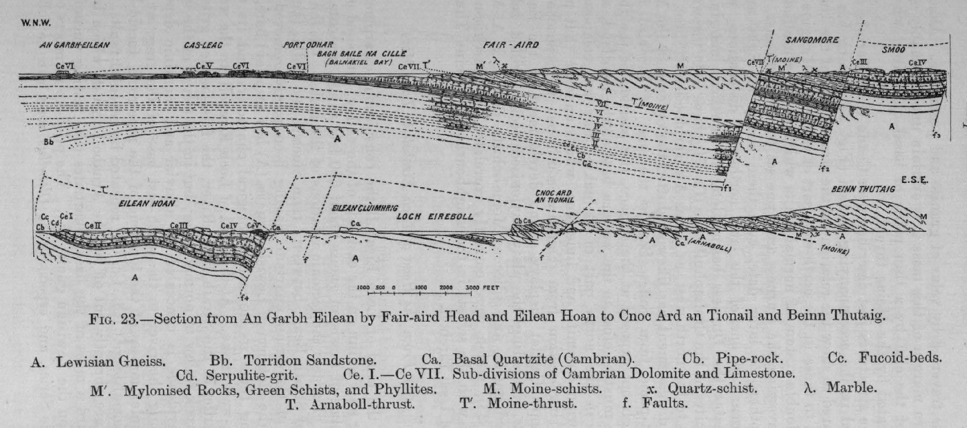
(Figure 23) Section across Fair Aird Head to Beinn Thutaig

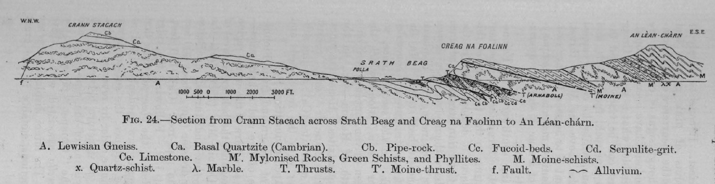
(Figure 24) Section from Crann Stacach across Strath Beag to Creag na Faolinn

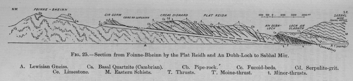
(Figure 25) Section from Foinaven to Sabhal Mòr.

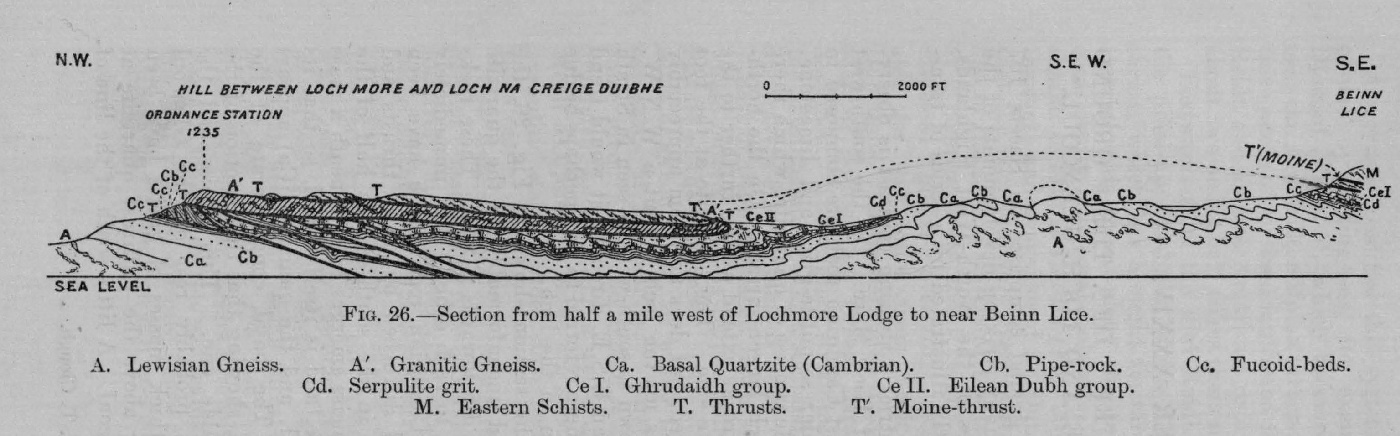
(Figure 26) Section from Loch More Lodge to Beinn Lice

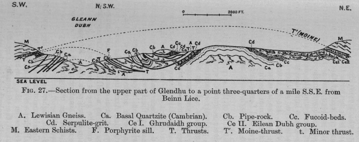
(Figure 27) Section, Glendhu to S.S.E. of Beinn Lice

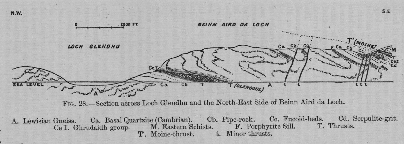
(Figure 28) Section across Loch Glendhu and N.E. side of Beinn Aird da Loch

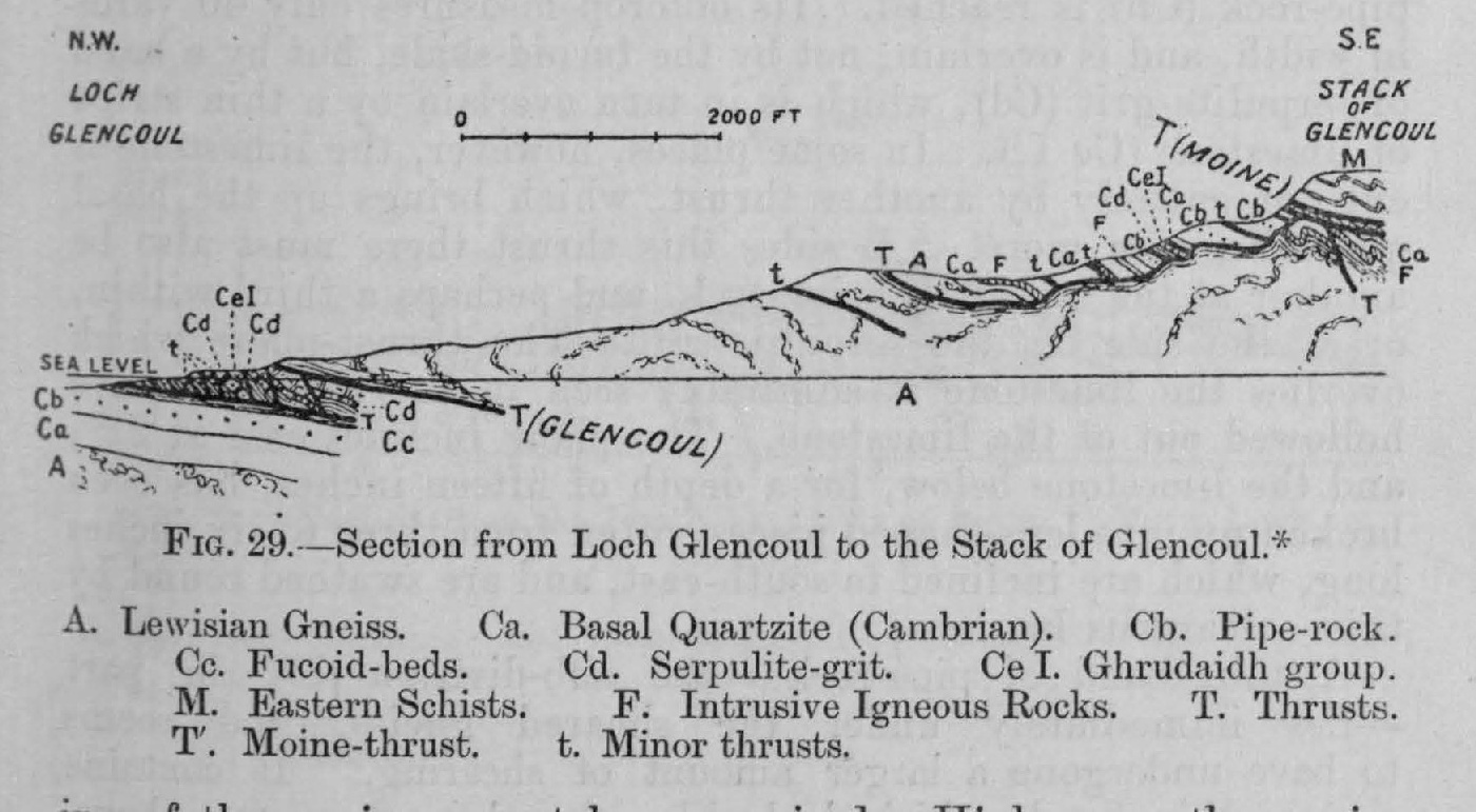
(Figure 29) Section from Loch Glencoul to the Stack of Glencoul

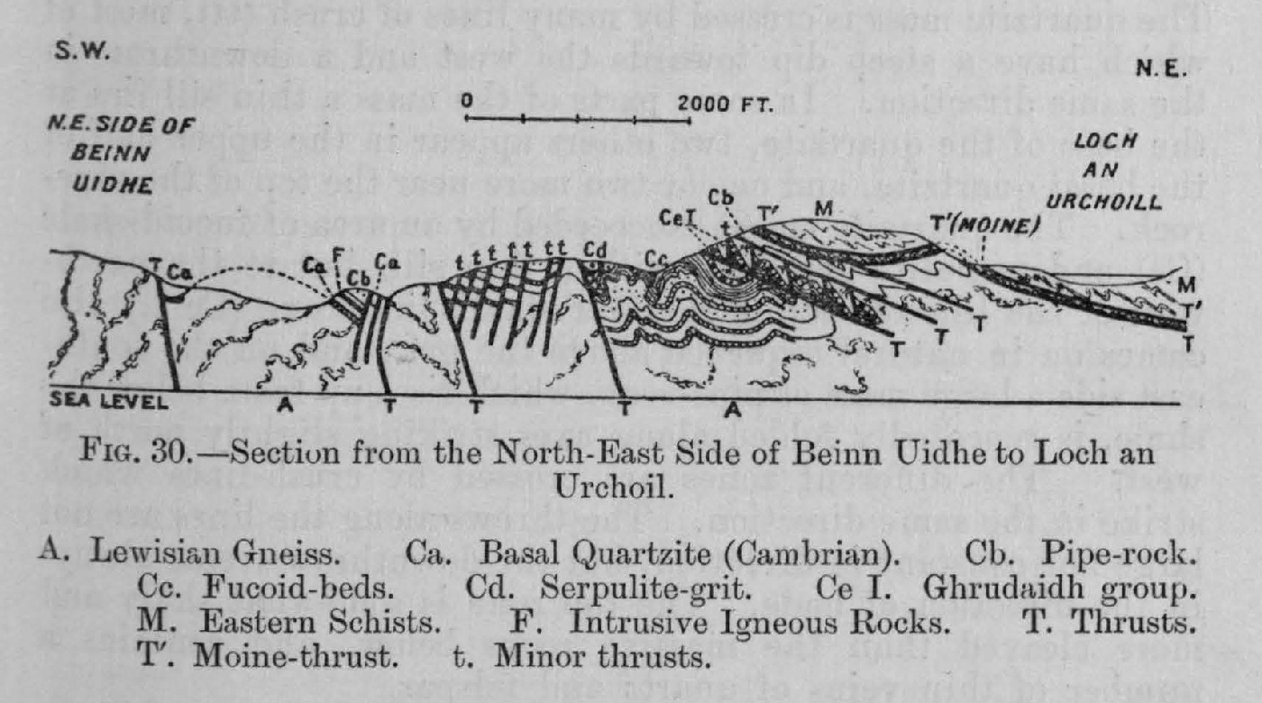
(Figure 30) Section from N.E. side of Beinn Uidhe to Loch an Urchoil

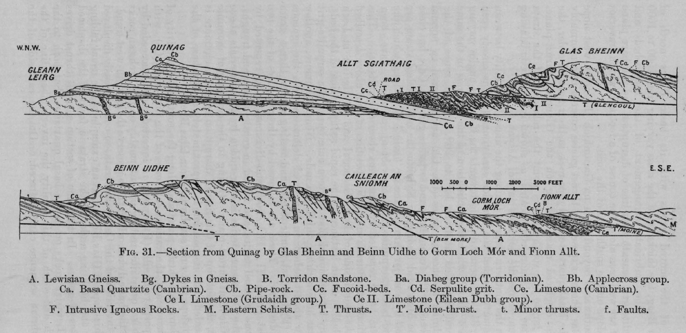
(Figure 31) Section from Quinag by Glas Bheinn and Beinn Uidhe to Gorm Loch More, and Fionn Allt

(Figure 32) Section from Beinn Garbh by Cnoc an Droighinn and Ben More, Assynt, to the River Cassley

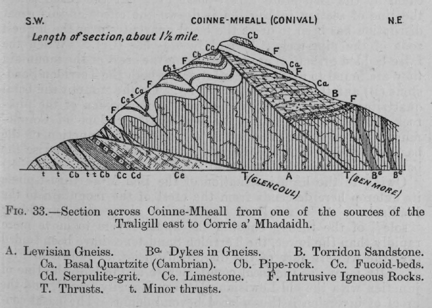
(Figure 33) Section across Coinne Mheall from one of sources of Traligill east to Corrie a' Mhadaidh

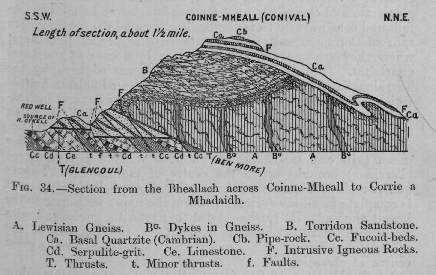
(Figure 34) Section from the Bealach across Coinne Mheall to Corrie a Mhadaidh

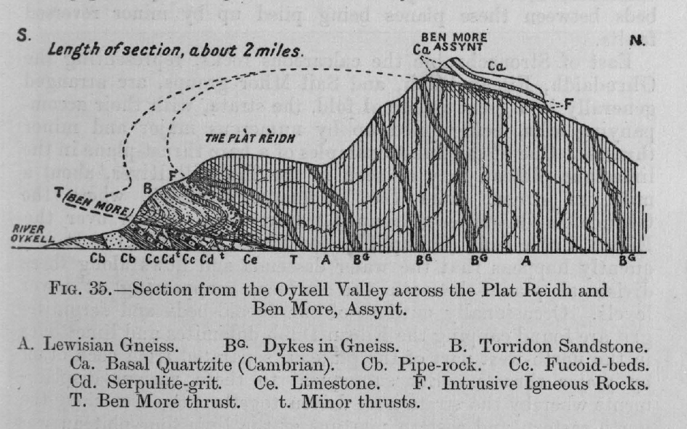
(Figure 35) Section from the Oykell Valley across the Plat Reidh and Ben More

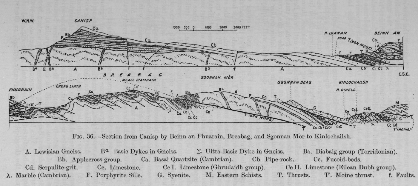
(Figure 36) Section from Canisp by Beinn an Fhuarain, Breabag, and Sgonnan Mòr to Kinlochailsh

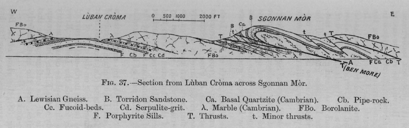
(Figure 37) Section from Lùban Cròma across Sgonnan Mor

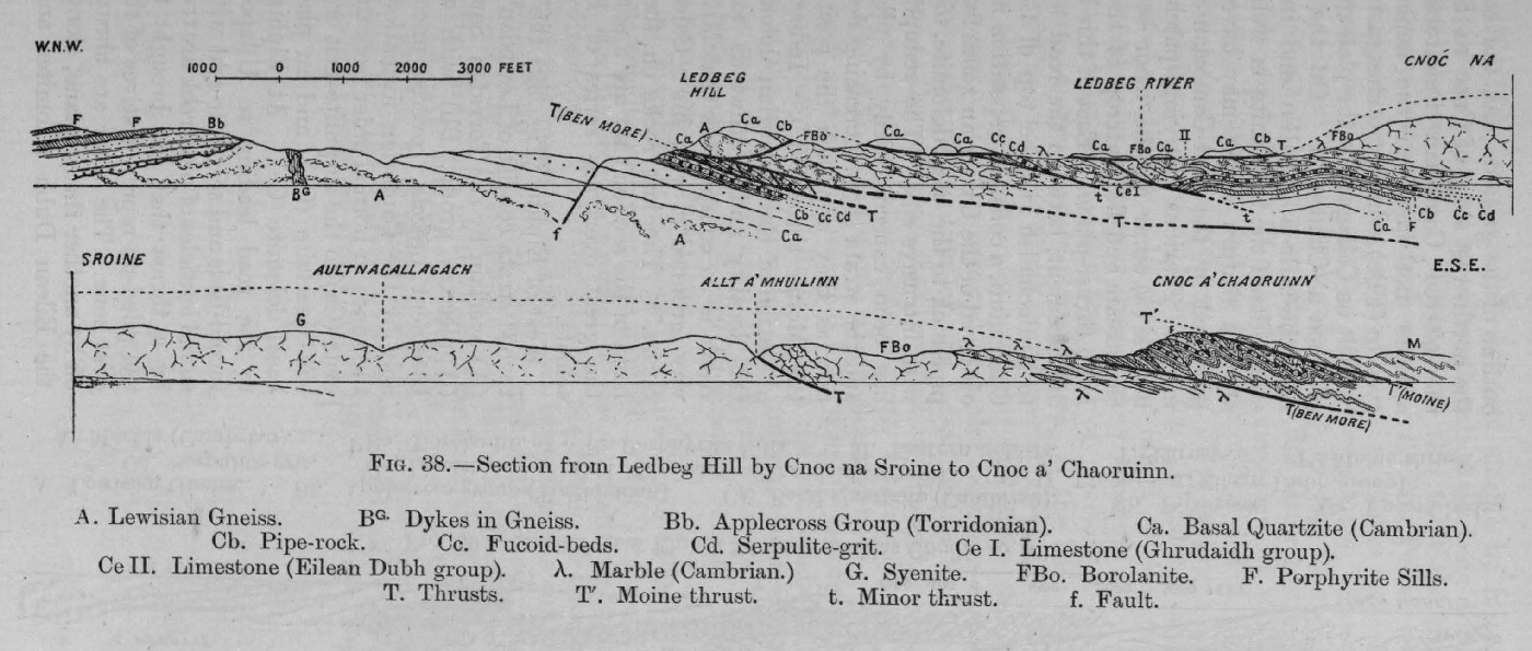
(Figure 38) Section from Ledbeg Hill by Cnoc na Sroine to Cnoc a' Chaoruinn

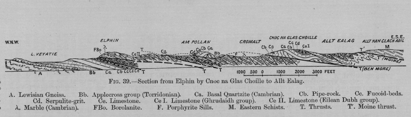
(Figure 39) Section from Elphin by Cnoc na Glas Choille to Allt Ealag

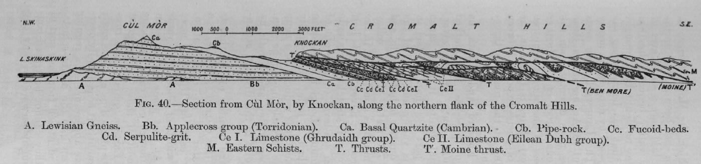
(Figure 40) Section from Cùl Mòr by Knockan along flanks of Cromalt Hills

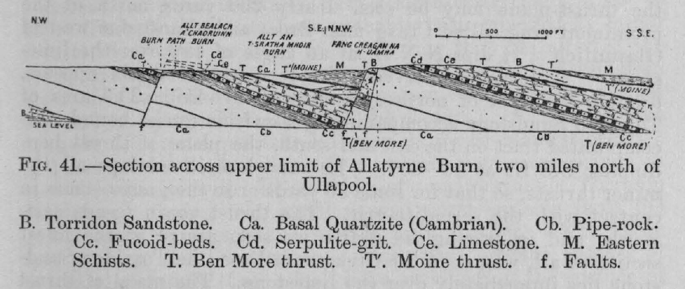
(Figure 41) Section across Allatryne Burn, north of Ullapool

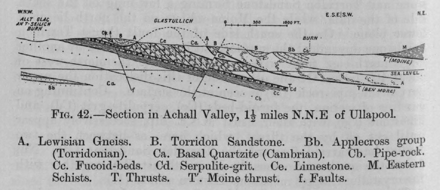
(Figure 42) Section in Achall Valley

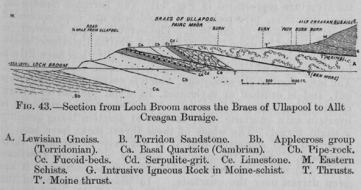
(Figure 43) Section from Loch Broom across the Braes of Ullapool, east to Allt Creagan Buraige

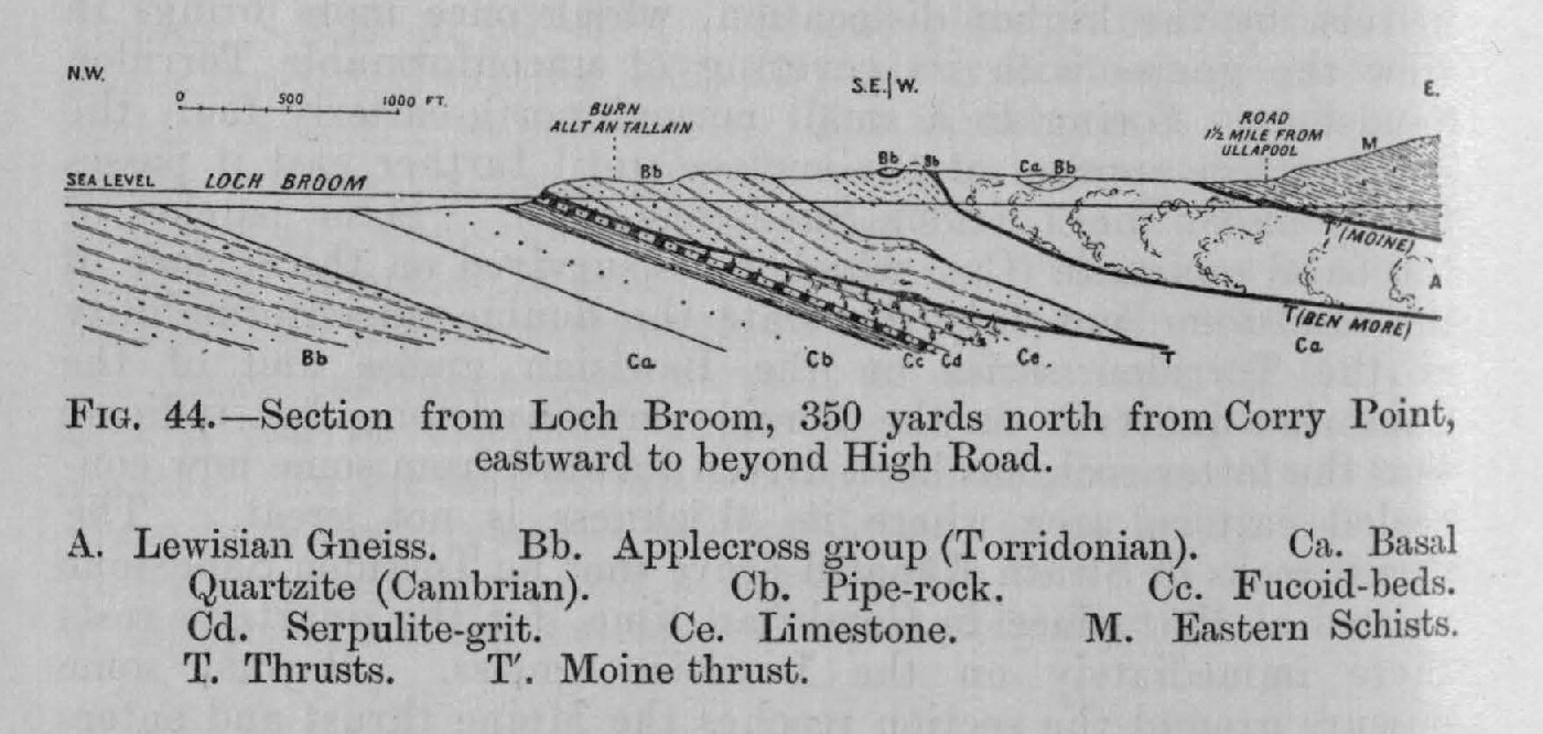
(Figure 44) Section from Loch Broom, near Corry Point, eastward d to beyond high road

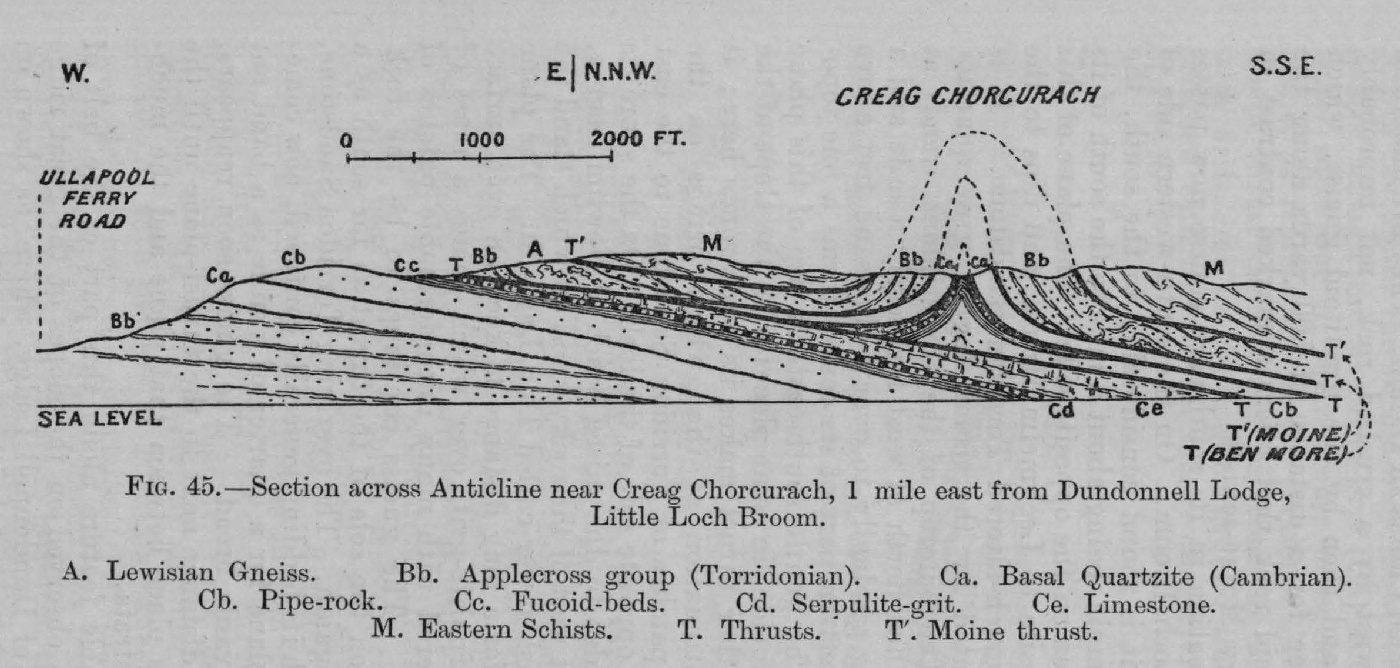
(Figure 45) Section across anticline near Creag Chorcurach east of Dundonnell Lodge, Little Loch Broom

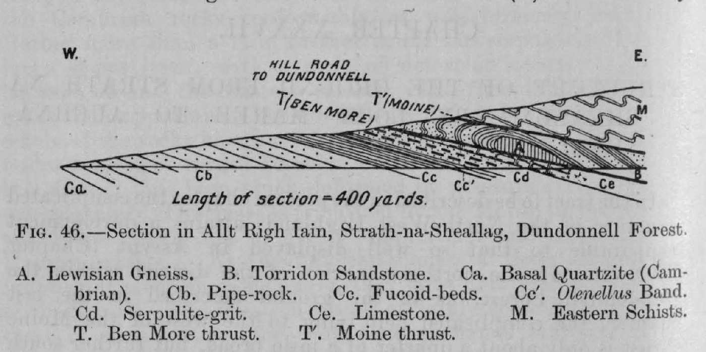
(Figure 46) Section in Allt Righ lain, Strath na Sheallag, Dundonnell Forest

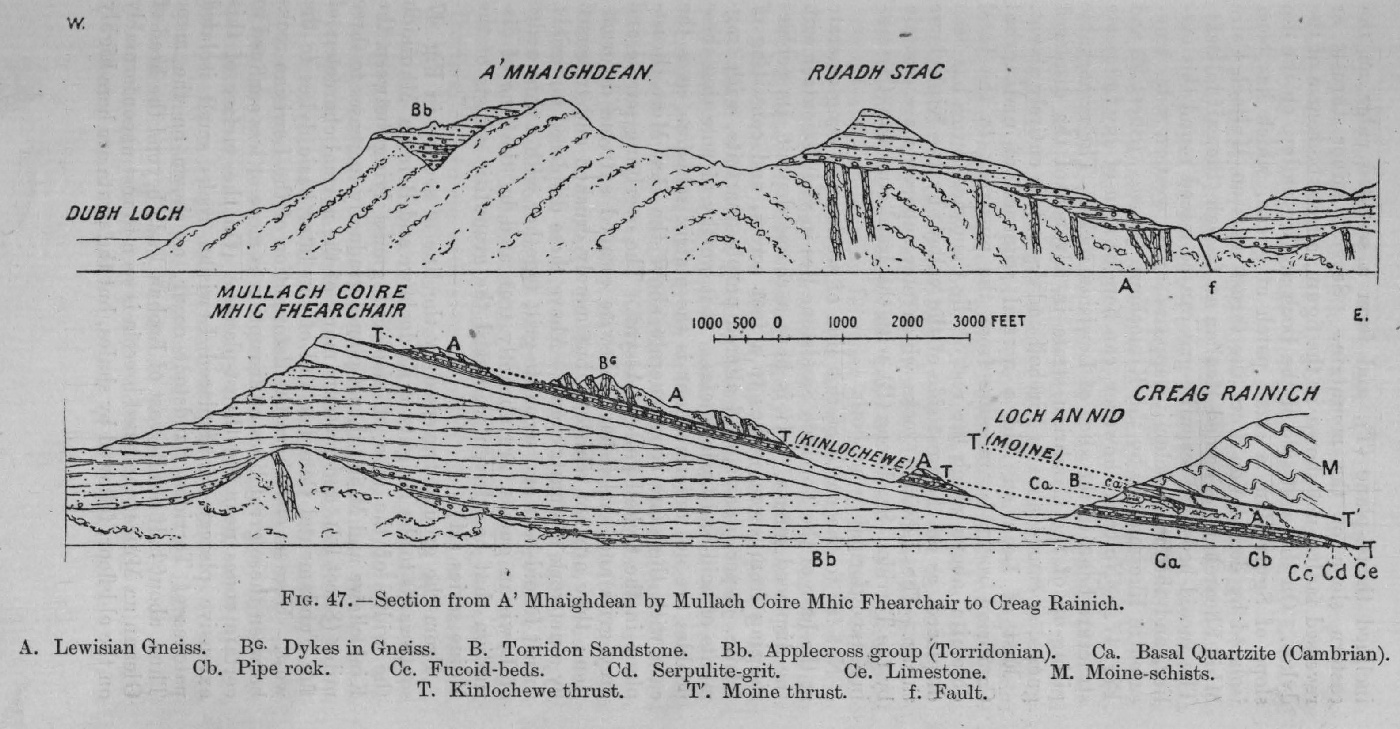
(Figure 47) Section from Dubh Loch across A' Mhaighdean and Mullach Coire Mhic Fhearchair to beyond Loch an Nid

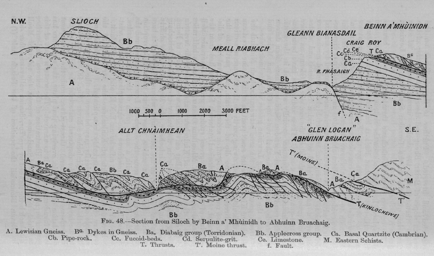
(Figure 48) Section from Slioch by Beinn a' Mhuinidh to Abhuinn Bruachaig

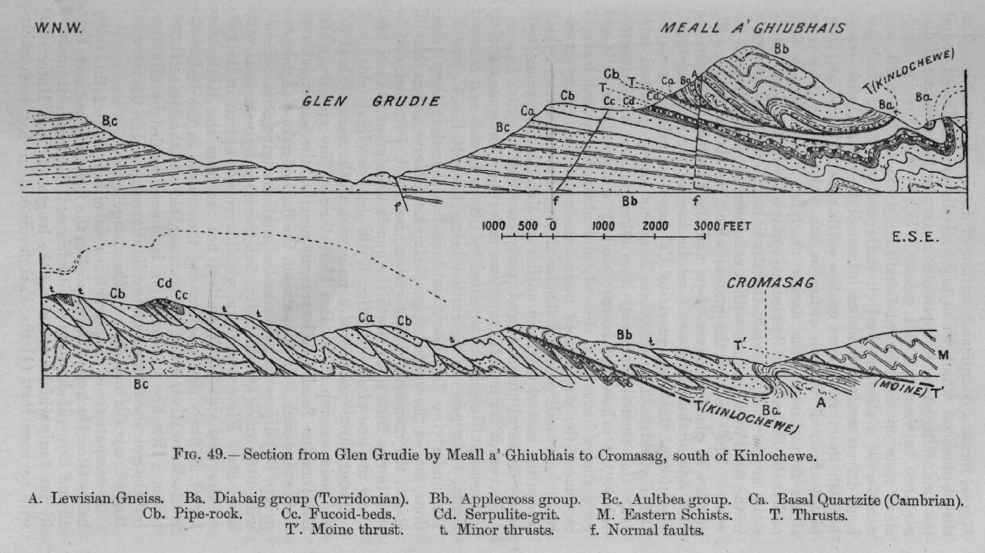
(Figure 49) Section from Glen Grudie to Cromasag, south of Kinlochewe

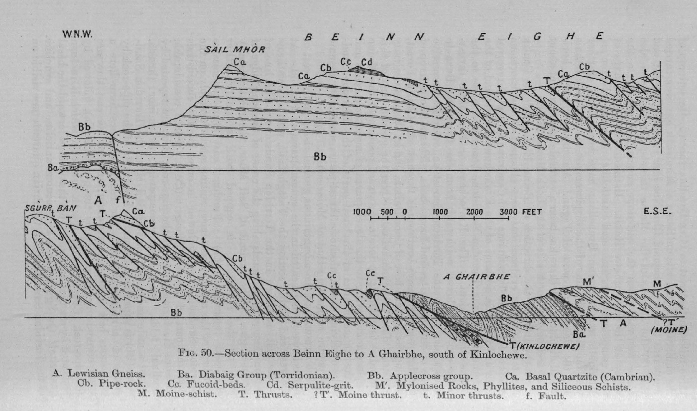
(Figure 50) Section across Beinn Eighe, Loch Maree

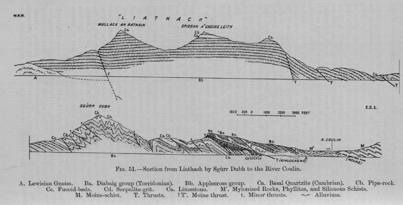
(Figure 51) Section from Liathach to Coulin River

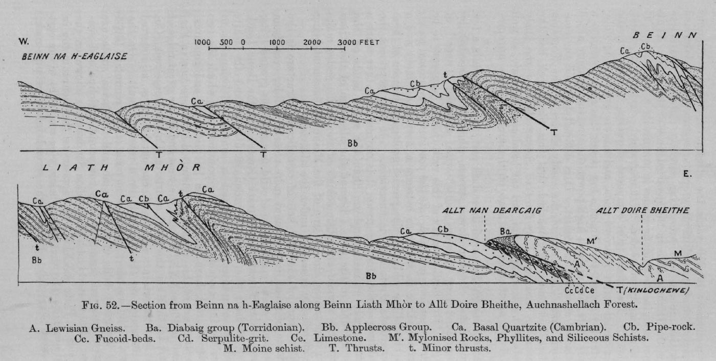
(Figure 52) Section across Beinn Liath Mhòr

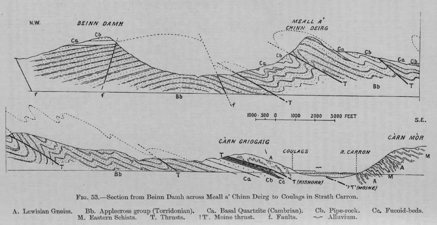
(Figure 53) Section from Beinn Damh across Meall a' Chinn Deirg to Strath Carron

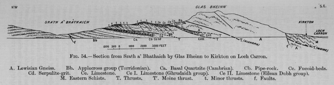
(Figure 54) Section from Srath a' Bhathaich to Kirkton, at head of Loch Carron

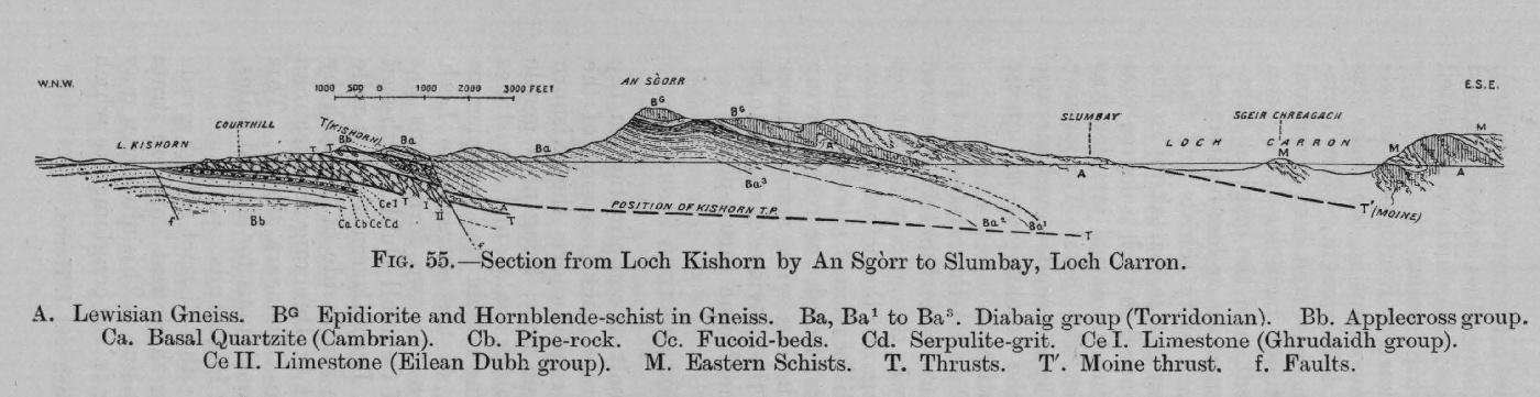
(Figure 55) Section from Loch Kishorn by An Sgòrr to Loch Carron

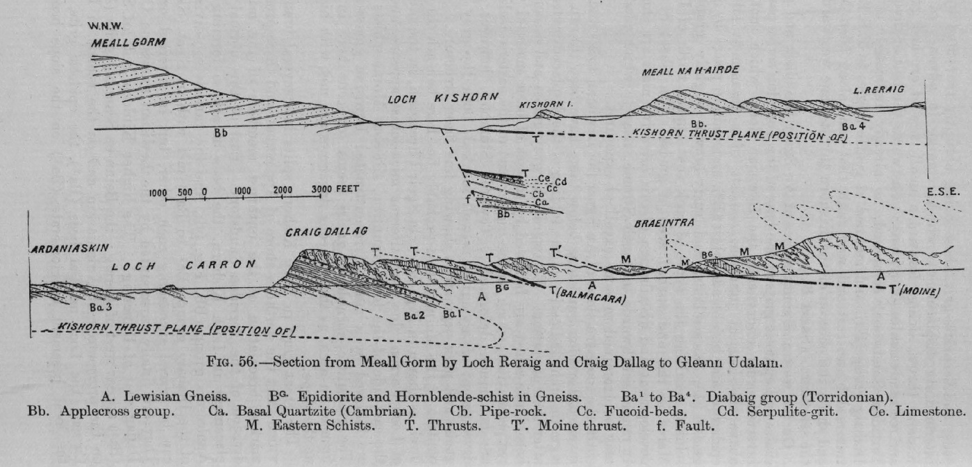
(Figure 56) Section from Meall Gorm by Reraig to Gleann Udalain

(Figure 57) Section from Loch Carron by Plockton to Gleann Udalain

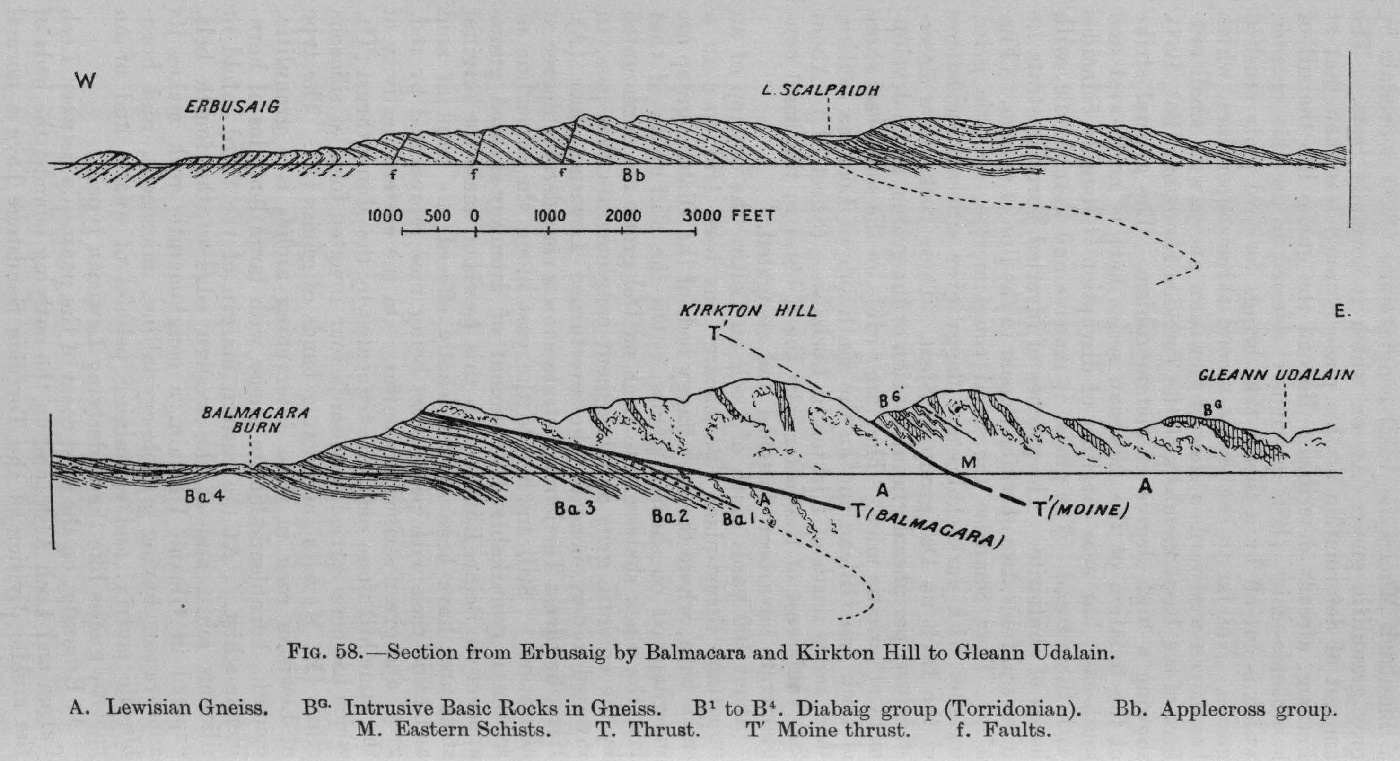
(Figure 58) Section from Erbusaig by Balmacara to Gleann Udalain

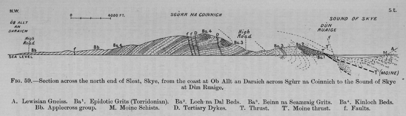
(Figure 59) Section from coast at Ob Allt an Daraich across Sgùrr na Coinnich to Sound of Skye at Dùn Ruaige

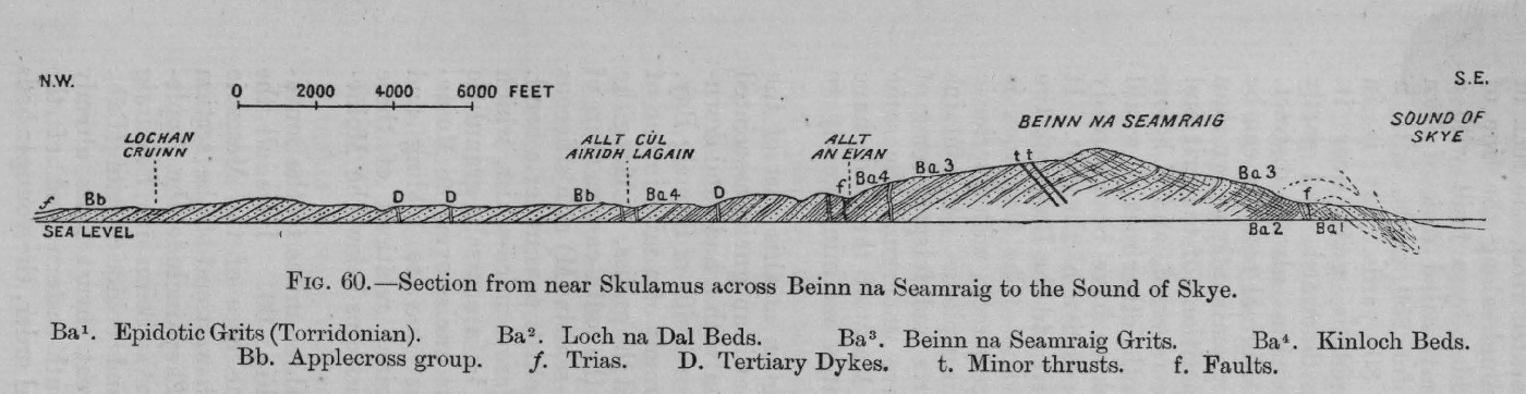
(Figure 60) Section from near Skulamus across Beinn na Seamraig to Sound of Skye

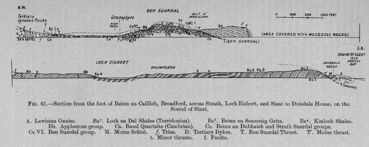
(Figure 61) Section across Strath and Sleat from the foot of Beinn na Caillich, near Broadford, to Isle Ornsay Bay

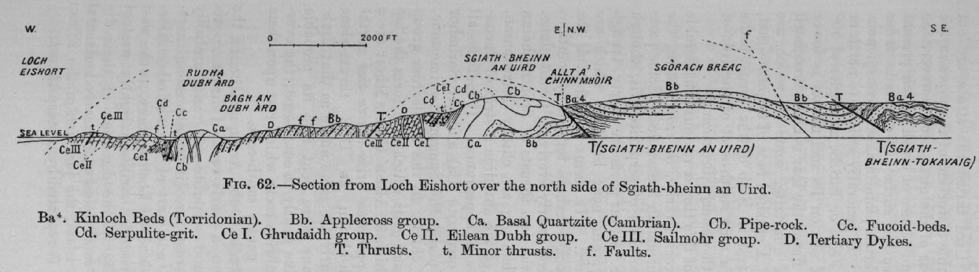
(Figure 62) Section from Loch Eishort over the north side of Sgiath-bheinn an Uird

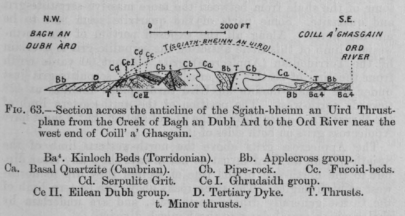
(Figure 63) Section across the anticline of the Sgiath-bheinn an Uird thrust-plane to the Ord River

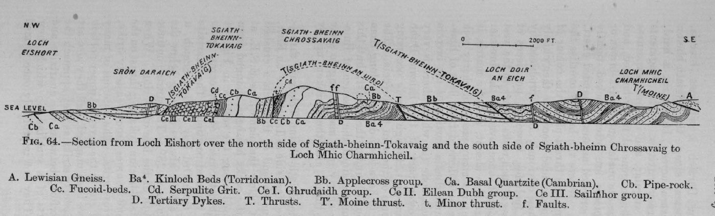
(Figure 64) Section from Loch Eishort over north side of Sgiath-bheinn-Tokavaig, &c., to Loch Mhic Charmhicheil

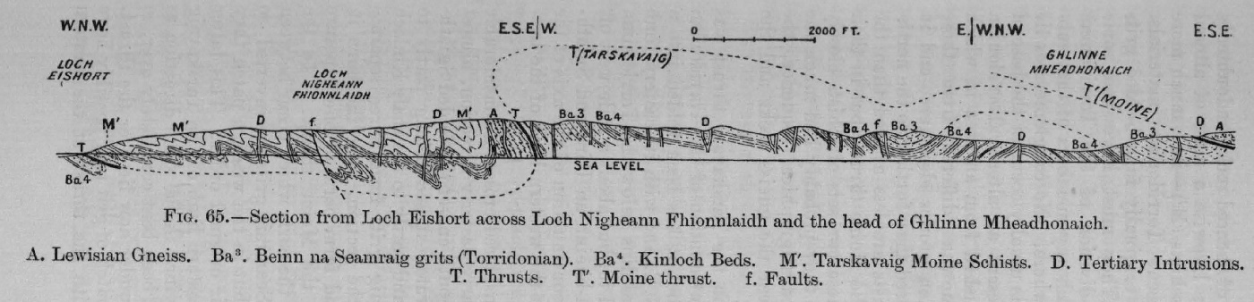
(Figure 65) Section from Loch Eishort across Loch Nigheann Fhionnlaidh and head of Ghlinne Mheadhonaich

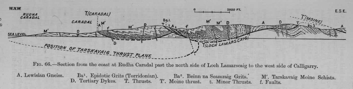
(Figure 66) Section from coast at Rudha Caradal past Loch Lamarscaig to west side of Calligarry

Map

Geological Map of the North-West Highlands of Scotland on the scale a four miles to one inch (1:253440)
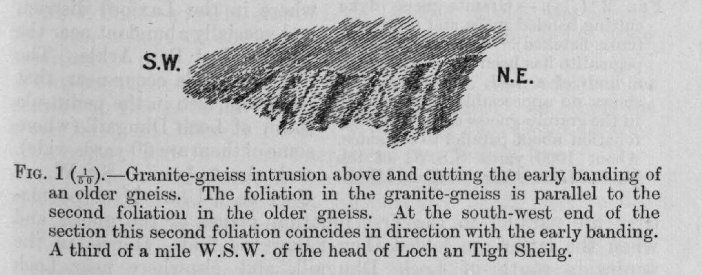
(Figure 1) (1:50) Granite-gneiss intrusion above and cutting the early banding of an older gneiss. The foliation in the granite-gneiss is parallel to the second foliation in the older gneiss. At the south-west end of the section this second foliation coincides in direction with the early banding. A third of a mile W.S.W. of the head of Loch an Tigh Sheilg.

(Figure 2) (1/100) Granite-gneiss dyke cutting banded gneiss and pegmatite (cross-hatched). One branch of the pegmatite has been introduced along a limb of a fold. The pegmatite shows no appreciable foliation, but in the granite-gneiss dyke there is a foliation about parallel to the sides. About 1000 yards S.S. W. of the head of Loch a' Gharbh Bhaid Mhòir.

(Figure 3) (1/24) Folded banded gneiss shc.wing thinning of the long limb and second foliation parallel to the axial planes of fold. South side of Loch na h-Adh, three miles west of Loch Stack.

(Figure 4) (1/240) Dyke of granite-gneiss with pegmatite rods cutting folded gneiss and coarse pegmatite (cross hatched). About a mile slightly south of east of Loch Stack Lodge. The dyke is foliated parallel to its side. The pegmatite shows no appreciable foliation.
(Figure 5) (1/10) Nearly horizontal pegmatite cutting nearly vertical banded gneiss. South side of Loch Eileanach. The pegmatite is banded parallel to its sides, but is crossed by a foliation parallel to the (modified) gneiss banding.
(Figure 6) (1/10) Gneiss with a band that has been sharply contorted, probably iu consequence of the rocks on one side having been moved past those on the other. Rather more than a third of a mile N.N.E. of the outlet of Gorm Loch.

(Figure 7) Intersection of the older epidiorite dykes by the later picrite intrusions on Sron a Bhuic, two miles south of the foot of Loch Assynt.

(Figure 8) Relation of newer to older planes of foliation in pyroxenic and hornblendic gneiss. Rudha Leumair, 3¾ miles north-west of Lochinver.

(Figure 9) (1:50) Ground plan of foliated basic dyke and acid gneiss, about 200 yards southeast of south end of Loch nam Buainichean. The marginal portion of the dyke is foliated parallel to the side. This portion, the foliation in it, and some quartz veins are folded and occasionally crossed by a strain-slip foliation parallel to the axial planes of fold. The interior of the dyke is foliated parallel to the same axial planes. A thin strip of gneiss next the dyke is foliated Parallel to the dyke side, and follows the same folds. The prominent foliation in the rest of the dyke is parallel to the axial planes of these folds. Near the south-east side of the exposure there are indications of an early banding in the gneiss.

(Figure 10) Generalised section proceeding from the coast 600 yards south of Regoilachy, Loch Maree, in an E.N.E. direction to the slopes of Slioch. A. Gneiss of the Fundamental Complex with dykes. BG. Hornblende Schist. Ag. Mica Schist. Am. Pre-Torridon Mylonised Rocks. Agi. Graphite Schist. Bb. Torridon Sandstone. Aλ. Limestone.

(Figure 11) Section from Loch Fada across Slioch to Gleann Bianasdail. A.Lewisian Gneiss. B. Torridonian Sandstone. Ca. Basal quartzite. Cb. Pipe-rock. Cc Fucoid beds. Cd Serpulite grit. C.e. Dolominte. T. Kinlochewe thrust-plane. f. fault.

(Figure 12) Section across Srath Lungard, showing the Torridonian Series lying upon an eroded platform of Lewisian Gneiss, A. Lewisian Gneiss. Ba. Diabaig Group. Bb. Applecross Group.

(Figure 13) Portion of vertical face of Torridon Sandstone (Applecross Group) with laminas in curves. Coast about a mile and a half east of the Red Point, five miles south of Loch Gairloch.

(Figure 14) Section from the Inner Sound of Raasay across Northern Applecross to Loch Torridon, showing the uneven surface of the Lewisian Gneiss and the strong overlap of the unconformable Torridonian Series. A. Lewisian Gneiss. BG. Pre-Torridonian dyke. Ba. Diabaig Group. Bb. Applecross Group. D. Basalt dykes.

(Figure 15) Cleaved Shale with seam of Grit (3 inches thick), showing over-folding and reversed faults, on shore 470 yards east of Colonel Murchison's Monument, Loch Alsh.

(Figure 16) Diagram showing the Formation of Outliers of Torridon Sandstone by folding and denudation in Post-Torridonian and Pre-Cambrian time. A. Lewisian Gneiss. Ba–Bc. Torridonian. Ca–Ce. Cambrian. Y. Pre-Torridonian surface of erosion. x. Pre-Cambrian plane of marine denudation.

(Figure 17) Vertical Section of Fucoid Beds, Serpulite Grit, and Ghrudaidh Dolomite and Limestone — An t-Sron, east side of Loch Eireboll.

(Figure 18) Vertical Section of Cambrian Strata, showing horizons of Intrusive Rocks (marked x) in Assynt.

(Figure 19) Ground Plan of possible Volcanic Vent, River Oykell, about three miles above Loch Ailsh. Figure 19a. Development of imbricate structure (H. M. Cadell). Figure 19b Major thrust plane or sole (H. M. Cadell). Figure 19c. Folding of thrust materials along major thrust-plane. (H. M. Cadell).

(Figure 20) Section from Meall Sgribhinn by Durness, Sangomore, and Meall Meadhonach to Arnaboll Hill and Loch Hope. A. Lewisian Gneiss. Bb. Torridon Sandstone. Ca. Basal Quartzite (Cambrian). Cb. Pipe-rock. Cc. Fucoid-beds. Cd. Serpulite Grit. Ce. Limestone. Ce I. to Ce VII. Cambrian Dolomite and Limestone. M′. Mylonized Rocks, Green Schists, and Phyllites. M. Moine-schists. x. Quartz Schist. λ. Marble. T. Thrusts. T′. Moine-thrust. f. Faults.

(Figure 21) Section from An t-Sron by Bealach Mhairi to Loch Hope. A. Lewisian Gneiss. Ca. Basal Quartzite (Cambrian). Cb. Pipe-rock. Cc. Fucoid-beds. Cd. Serpulite-grit. Ce I. Limestone (Ghrudaidh group). M′. Mylonised Rocks, Green Schists and Phyllites. M. Moine-schists. x. Quartz-schist. λ. Marble. T. Arnaboll-thrust. T′. Moine-thrust. t. Minor-thrust. f. Faults.

(Figure 22) Section from Leathad by An Corr Eilean and Eireboll House to Loch Hope. A. Lewisian Gneiss. Ca. Basal Quartzite (Cambrian). Cb. Pipe-rock. Cc. Fucoid-beds. Cd. Serpulite-grit. Ce. Limestone. Ce I. Dolomite (Ghrudaidh group). Ce II. Dolomite (Eilean Dubh group). M′. Mylonised Rocks, Green Schists, and Phyllites. M. Moine-schists. x. Quartz-schists. λ. Marble. T. Arnaboll-thrust. T′. Moine-thrust.

(Figure 23) Section from An Garbh Eilean by Fair-aird Read and Eilean Hoan to Cnoc Ard an Tionail and Beinn Thutaig. A. Lewisian Gneiss. Bb. Torridon Sandstone. Ca. Basal Quartzite (Cambrian). Cb. Pipe-rock. Cc. Fucoid-beds. Cd. Serpulite-grit. Ce. I. — Ce VII. Sub-divisions of Cambrian Dolomite and Limestone. M′. Mylonised Rocks, Green Schists, and Phyllites. M. Moine-schists. x. Quartz-schist. λ. Marble. T. Arnaboll-thrust. T′. Moine-thrust. f. Faults.

(Figure 24) Section from Crann Stacach across Srath Beag and Creag na Faolinn to An Lean-charn. A. Lewisian Gneiss. Ca. Basal Quartzite (Cambrian). Cb. Pipe-rock. Cc. Fucoid-beds. Cd. Serpulite-grit. Ce. Limestone. M′. Mylonised Rocks, Green Schists, and Phyllites. M. Moine-schists. x. Quartz-schist. λ. Marble. T. Thrusts. T′. Moine-thrust. f. Fault. [symbol] Alluvium.

(Figure 25) Section from Foinne-Bheinn by the Plat Reidh and An Dubh-Loch to Sabhal Mòr. A. Lewisian Gneiss. Ca. Basal Quartzite (Cambrian). Cb. Pipe-rock. Cc. Fucoid-beds. Cd. Serpulite-grit. Ce. Limestone. M. Eastern Schists. T. Thrusts. T′. Moine-thrust. t. Minor-thrusts.

(Figure 26) Section from half a mile west of Lochmore Lodge to near Beinn Lice. A. Lewisian Gneiss. A′ Granitic Gneiss. Ca. Basal Quartzite (Cambrian). Cb. Pipe-rock. Cc. Fucoid-beds. Cd. Serpulite grit. Ce I. Ghrudaidh group. Ce II. Eilean Dubh group. M. Eastern Schists. T. Thrusts. T′. Moine-thrust.

(Figure 27) Section from the upper part of Glendhu to a point three-quarters of a mile S.S.E. from Beinn Lice. A. Lewisian Gneiss. Ca. Basal Quartzite (Cambrian). Cb. Pipe-rock. Cc. Fucoid-beds. Cd. Serpulite-grit. Ce I. Ghrudaidh group. Ce U. Eilean Dubh group. M. Eastern Schists. F. Porphyrite sill. T. Thrusts. T′. Moine-thrust. t. Minor thrust.

(Figure 28) Section across Loch Glendhu and the North-East Side of Beinn Aird da Loch. A. Lewisian Gneiss. Ca. Basal Quartzite (Cambrian). Cb. Pipe-rock. Cc. Fucoid-beds. Cd. Serpulite-grit. Ce I. Ghrudaidh group. M. Eastern Schists. F. Porphyritc Sill. T. Thrusts. T′. Moine-thrust. t. Minor thrusts.

(Figure 29) Section from Loch Glencoul to the Stack of Glencoul.<ref>The Stack of Glencoul is not named on the one-inch map, but it lies nearly two miles south-east from Glencoul cottage.</ref> A. Lewisian Gneiss. Ca. Basal Quartzite (Cambrian). Cb. Pipe-rock. Cc. Fucoid-beds. Cd. Serpulite-grit. Ce I. Ghrudaidh group. M. Eastern Schists. F. Intrusive Igneous Rocks. T. Thrusts. T′. Moine-thrust. t. Minor thrusts.

(Figure 30) Section from the North-East Side of Beinn Uidhe to Loch an Urchoil. A. Lewisian Gneiss. Ca. Basal Quartzite (Cambrian). Cb. Pipe-rock. Cc. Fucoid-beds. Cd. Serpulite-grit. Ce I. Ghrudaidh group. M. Eastern Schists. F. Intrusive Igneous Rocks. T. Thrusts. T′. Moine-thrust. t. Minor thrusts.

(Figure 31) Section from Quinag by Glas Bheinn and Beinn Uidhe to Gorin Loch Mar and Fionn Allt. A. Lewisian Gneiss. BG. Dykes in Gneiss. B. Torridon Sandstone. Ba. Diabeg group (Torridonian). Bb. Applecross group. Ca. Basal Quartzite (Cambrian). Cb. Pipe-rock. Cc. Fucoid-beds. Cd. Serpulite grit. Ce. Limestone (Cambrian). Ce I. Limestone (Grudaidh group.) Ce II. Limestone (Eilean Dubh group). F. Intrusive Igneous Rocks. M. Eastern Schists. T. Thrusts. T′. Moine-thrust. t. Minor thrusts. f. Faults.

(Figure 33) Section across Coinne-Mheall from one of the sources of the Traligill east to Corrie a' Mhadaidh. A. Lewisian Gneiss. BG. Dykes in Gneiss. B. Torridon Sandstone. Ca. Basal Quartzite (Cambrian). Cb. Pipe-rock. Cc. Fucoid-beds. Cd. Serpulite-grit. Ce. Limestone. F. Intrusive Igneous Rocks. T. Thrusts. t. Minor thrusts.

(Figure 34) Section from the Bheallach across Coinne-Mheall to Corrie a Mhadaidh. A. Lewisian Gneiss. BG. Dykes in Gneiss. B. Torridon Sandstone. Ca. Basal Quartzite (Cambrian). Cb. Pipe-rock. Cc. Fucoid-beds. Cd. Serpulite-grit. Ce. Limestone. F. Intrusive Igneous Rocks. T. Thrusts. t. Minor thrusts. f. Faults.

(Figure 35) Section from the Oykell Valley across the Plat Reidh and Ben More, Assynt. A. Lewisian Gneiss. BG. Dykes in Gneiss. B. Torridon Sandstone. Ca. Basal Quartzite (Cambrian). Cb. Pipe-rock. Cc. Fucoid-beds. Cd. Serpulite-grit. Ce. Limestone. F. Intrusive Igneous Rocks. T. Ben More thrust. t. Minor thrusts.

(Figure 36) Section from Canisp by Beinn an Fhuarain, Breabag, and Sgonnan Mòr. to Kinlochailsh. A. Lewisian Gneiss. Σ. Basic Dykes in Gneiss. E. Ultra-Basic Dyke in Gneiss. Ba. Diabaig group (Torridonian). Bb. Applecross group. Ca. Basal Quartzite (Cambrian). Cb. Pipe-rock. Cc. Fucoid-beds. Ce I. Limestone (Ghrudaidh group). Ce II. Limestone (Eilean Dubh group). G. Syenite. M. Eastern SchisT′s. T. Thrusts. T′. Moine thrust. f. Faults Cd. Serpulite-grit. Ce. Limestone. λ. Marble (Cambrian). F. Porphyrite Sills.

(Figure 37) Section from Lùban Cròma across Sgonnan Mòr. A. Lewisian Gneiss. B. Torridon Sandstone. Ca. Basal Quartzite (Cambrian). Cb. Pipe-rock. Cc. Fucoid-beds. Cd. Serpulite-grit. λ. Marble (Cambrian). FBo. Borolanite. F. Porphyrite Sills. T. Thrusts. t. Minor thrusts.

(Figure 38) Section from Ledbeg Hill by Cnoc na Sroine to Cnoc a' Chaoruinn. A. Lewisian Gneiss. BG. Dykes in Gneiss. Bb. Applecross Group (Torridonian). Ca. Basal Quartzite (Cambrian Cb. Pipe-rock. Cc. Fucoid-beds. Cd. Serpulite-grit. Ce I. Limestone (Ghrudaidh group). Ce II. Limestone (Eileen Dubh group). λ. Marble (Cambrian.) G. Syenite. FBo. Borolanite. F. Porphyrite Sills. T. Thrusts. T′. Moine thrust. t. Minor thrust. f. Fault.

(Figure 39) Section from Elphin by Cnoc na Glas Choille to Allt Ealag. A. Lewisian Gneiss. Bb. Applecross group (Torridonian). Ca. Basal Quartzite (Cambrian). Cb. Pipe-rock. Cc. Fucoid-beds. Cd. Serpulite-grit. Ce. Limestone. Ce I. Limestone (Ghrudaidh group). Ce II. Limestone (Eilean Dubh group). λ Marble (Cambrian). FBo. Borolanite. F. Porphyrite Sills. M. Eastern Schists. T. Thrusts. T′. Moine thrust.

(Figure 40) Section from Cùl Mòr, by Knockan, along the northern flank of the Cromalt Hills. A. Lewisian Gneiss. Bb. Applecross group (Torridonian). Ca. Basal Quartzite (Cambrian). Cb. Pipe-rock. Cc. Fucoid-beds. Cd. Serpulite-grit. Ce I. Limestone (Ghrudaidh group). Ce II. Limestone (Eilean Dubh group). M. Eastern Schists. T. Thrusts. T′. Moine thrust.

(Figure 41) Section across upper limit of Allatyrne Burn, two miles north of Ullapool. B. Torridon Sandstone. Ca. Basal Quartzite (Cambrian). Cb. Pipe-rock. Cc. Fucoid-beds. Cd. Serpulite-grit. Ce. Limestone. M. Eastern Schists. T. Ben More thrust. T′. Moine thrust. f. Faults.

(Figure 42) Section in Achall Valley, 1½ miles N.N.E of Ullapool. A. Lewisian Gneiss. B. Torridon Sandstone. Bb. Applecross group (Torridonian). Ca. Basal Quartzite (Cambrian). Cb. Pipe-rock. Cc. Fucoid-beds. Cd. Serpulite-grit. Ce. Limestone. M. Eastern Schists. T. Thrusts. T′. Moine thrust. f. Faults.

(Figure 43) Section from Loch Broom across the Braes of Unapool to Allt Creagan Buraige. A. Lewisian Gneiss. B. Torridon Sandstone. Bb. Applecross group (Torridonian). Ca. Basal Quartzite (Cambrian). Cb. Pipe-rock. Cc. Fucoid-beds. Cd. Serpulite-grit. Ce. Limestone. M. Eastern Schists. G. Intrusive Igneous Rock in Moine-schist. T. Thrusts. T′. Moine thrust.

(Figure 44) Section from Loch Broom, 350 yards north from Corry Point, eastward to beyond High Road. A. Lewisian Gneiss. Bb. Applecross group (Torridonian). Ca. Basal Quartzite (Cambrian). Cb. Pipe-rock. Cc. Fucoid-beds. Cd. Serpulite-grit. Ce. Limestone. M. Eastern Schists. T. Thrusts. T′. Moine thrust.

(Figure 45) Section across Anticline near Creag Chorcurach, 1 mile east from Dundonnell Lodge, Little Loch Broom. A. Lewisian Gneiss. Bb. Applecross group (Torridonian). Ca. Basal Quartzite (Cambrian). Cb. Pipe-rock. Cc. Fucoid-beds. Cd. Serpulite-grit. Ce. Limestone. M. Eastern Schist& T. Thrusts. T′. Moine thrust.

(Figure 46) Section in Allt Righ Iain, Strath-na-Sheallag, Dundonnell Forest. A. Lewisian Gneiss. B. Torridon Sandstone. Ca. Basal Quartzite (Cambrian). Cb. Pipe-rock. Cc. Fucoid-beds. Cc. Olenellus Band. Cd. Serpulite-grit. Ce. Limestone. M. Eastern Schists. T. Ben More thrust. T′. Moine thrust.

(Figure 47) Section from A' Mhaighdean by Mullach Coire Mhic Fhearchair to Creag Rainich. A. Lewisian Gneiss. BG. Dykes in Gneiss. B. Torridon Sandstone. Bb. Applecross group (Torridonian). Ca. Basal Quartzite (Cambrian). Cb. Pipe rock. Cc. Fucoid-beds. Cd. Serpulite-grit. Ce. Limestone. M. Moine-schists. T. Kinlochewe thrust. T′. Moine thrust. f. Fault.

(Figure 48) Section from Siloch by Beinn a' Mhùinnidh to Abhuinn Bruachaig. A. Lewisian Gneiss. BG. Dykes in Gneiss. Ba. Diabaig group (Torridonian). Bb. Applecross group. Ca. Basal Quartzite (Cambrian). Cb. Pipe-rock. Cc. Fucoid-beds. Cd. Serpulite-grit. Ce. Limestone. M. Eastern Schists. T. Thrusts. T′. Moine thrust. f. Fault.

(Figure 49) Section from Glen Grudie by Meall a' Ghiubhais to Cromasag, south of Kinlochewe. A. Lewisian.Gneiss. Ba. Diabaig group (Torridonian). Bb. Applecross group. Be. Aultbea group. Ca. Basal Quartzite (Cambrian). Cb. Pipe-rock. Cc. Fucoid-beds. Cd. Serpulite-grit. M. Eastern Schists. T. Thrusts. T′. Moine thruit. t. Minor thrusts. f. Normal faults.

(Figure 50) Section across Beinn Eighe to A Ghairbhe, south of Kinlochewe. A. Lewisian Gneiss. BA.. Diabaig Group (Torridonian). Bb. Applecross group. Ca. Basal Quartzite (Cambrian). Cb. Pipe-rock. Cc. Fucoid-beds. Cd. Serpulite-grit. M′. Mylonised Rocks, Phyllites, and Siliceous Schists. M. Moine-schist. T. Thrusts. ? T′. Moine thrust. t. Minor thrusts. f. Fault.

(Figure 51) Section from Liathach by Sgùrr Dubh to the River Coulin. A. Lewisian Gneiss. Ba. Diabaig group (Torridonian). Bb. Applecross group. Ca. Basal Quartzite (Cambrian). Ch. Pipe-rock. Cc. Fucoid-beds. Cd. Serpulite-grit. Ce. Limestone. M′. Mylonised Rocks, Phyllites, and Siliceous Schists. M. Moine-schist. T. Thrusts. ? T′. Moine thrust. t. Minor thrusts. [symbol] Alluvium.

(Figure 52) Section from Beinn na h-Eaglaise along Beinn Liath Mhòr to Allt Doire Bheithe, Auchnashellach Forest. A. Lewisian Gneiss. Ba. Diabaig group (Torridonian). Bb. Applecross Group. Ca. Basal Quartzite (Cambrian). Cb. Pipe-rock. Cc. Fucoid-beds. Cd. Serpulite-grit. Ce. Limestone. M′. Mylonised Rocks, Phyllites, and Siliceous Schists. M. Moine schist. T. Thrusts. t Minor thrusts.

(Figure 53) Section from Beinn Damh across Meall a' Chinn Deirg to Coulags in Strath Carron. A. Lewisian Gneiss. Bb. Applecross group (Torridonian). Ca. Basal Quartzite (Cambrian). Cb. Pipe-rock. Cc. Fucoid-beds. M. Eastern Schists. T. Thrusts. ? T′. Moine thrust. f. Faults. [symbol] Alluvium.

(Figure 54) Section from Srath a' Bhathaich by Glas Bheinn to Kirkton on Loch Carron. A. Lewisian Gneiss. Bb. Applecross group (Torridonian). Ca. Basal Quartzite (Cambrian). Cb. Pipe-rock. Cc. Fucoid-beds. Cd. Serpulite-grit. Ce. Limestone. Ce I. Limestone (Ghrudaidh group). Ce II. Limestone (Eilean Dubh group'. M. Eastern Schists. T. Thrusts. T′. Moine thrust. t. Minor thrusts. f. Faults.

(Figure 55) Section from Loch Kishorn by An Sgòrr to Slumbay, Loch Carron. A. Lewisian Gneiss. Ba Epidiorite and Hornblende-schist in Gneiss. Ba, Ba1 to Ba3. Diabaig group (Torridonian). Bb. Applecross group. Ca. Basal Quartzite (Cambrian). Cb. Pipe-rock. Cc. Fucoid-beds. Cd. Serpulite-grit. Ce I. Limestone (Ghrudaidh group).  Ce H. Limestone (Eilean Dubh group). M. Eastern Schists. T. Thrusts. T′. Moine thrust. f. Faults.

(Figure 56) Section from Meall Gorm by Loch Reraig and Craig Dallag to Gleann Udalain. A. Lewisian Gneiss. BG Epidiorite and Hornblende-schist in Gneiss. Ba1 to Ba4. Diabaig group (Torridonian). Bb. Applecross group. Ca. Basal Quartzite (Cambrian). Cb. Pipe-rock. Cc. Fucoid-beds. Cd. Serpulite-grit. Ce. Limestone. M. Eastern Schists. T. Thrusts. T′. Moine thrust. f. Fault.

(Figure 57) Section from Loch Carron by Flockton and Beinn Raimh to Gleann Udalain. A. Lewisian Gneiss. ti° Epidiorite and Hornblende-schist in Gneiss. Ba1 to Ba4. Diabaig group (Torridonian). Bb. Applecross group. M. Eastern Schists. D. Tertiary Dyke. T. Thrusts. T′. Moine thrust. f. Fault.

(Figure 58) Section from Erbusaig by Balmacara and Kirkton Hill to Gleann Udalain. A. Lewisian Gneiss. BG Intrusive Basic Rocks in Gneiss. Bt to B*. Diabaig group (Torridonian). Bb. Applecross group. M. Eastern Schists. T. Thrust. T′ Moine thrust. f. Faults.

(Figure 59) Section across the north end of Sleat, Skye, from the coast at Ob Allt an Daraich across Sgùrr na Coinnich to the Sound of Skye at Dùm Ruaige. A. Lewisian Gneiss. Bal. Epidotic Grits (Torridonian). Ba'. Loch na Dal Beds. Be. Beinn na Seamraig Grits. Ba4. Kinloch Beds. Bb. Applecross group. M. Moine Schists. D. Tertiary Dykes. T. Thrust. T. Moine thrust. f. Faults.

(Figure 60) Section from near Skulamus across Beinn na Seamraig to the Sound of Skye. Ba1. Epidotic Grits (Torridonian). Ba2. Loch na Dal Beds. Ba3. Beinn na Seamraig Grits. Ba4. Kinloch Beds. Bb. Applecross group. f. Trias. D. Tertiary Dykes. t. Minor thrusts. f. Faults.

(Figure 61) Section from the foot of Beinn na Caillich, Broadford, across Strath, Loch Eishort, and Sleat to Duisdale House, on the Sound of Sleat. A. Lewisian Gneiss. Ba2. Loch na Dal Shales (Torridonian). Ba3. Beinn na Seamraig Grits. Ba4. Kinloch Shales. Bb. Applecross group. Ca. Basal Quartzite (Cambrian). Ce. Beinn an Dubhaich and Strath Suardal groups. Ce VI. Ben Suardal group. M. Moine Schist. f. Trias. D. Tertiary Dykes. T. Ben Suardal Thrust. T′. Moine thrust. t. Minor thrusts. f. Faults.

(Figure 62) Section from Loch Eishort over the north side of Sgiath-bheinn an Uird. Ba4. Kinloch Beds (Torridonian). Bb. Applecross group. Ca. Basal Quartzite (Cambrian). Cb. Pipe-rock. Cc. Fucoid-beds. Cd. Serpulite-grit. Ce I. Ghrudaidh group. Ce II. Eilean Dubh group. Ce III. Sailmohr group. D. Tertiary Dykes. T. Thrusts. t. Minor thrusts. f. Faults.

(Figure 63) Section across the anticline of the Sgiath-bheinn an Uird Thrust-plane from the Creek of Bagh an Dubh Ard to the Ord River near the west end of Coill' a' Ghasgain. Ba4. Kinloch Beds (Torridonian). Bb. Applecross group. Ca. Basal Quartzite (Cambrian). Cb. Pipe-rock. Cc. Fucoid-beds. Cd. Serpulite Grit. Ce I. Ghrudaidh group. Ce II. Eilean Dubh group. D. Tertiary Dyke. T. Thrusts. t. Minor thrusts.

(Figure 64) Section from Loch Eishort over the north side of Sgiath-bheinn-Tokavaig and the south side of Sgiath-bheinn Chrossavaig to Loch Mhic Charmhicheil. A. Lewisian Gneiss. Ba4. Kinloch Beds (Torridonian). Bb. Applecross group. Ca. Basal Quartzite (Cambrian). Cb. Pipe-rock. Cc. Fucoid-beds. Cd. Serpulite Grit. Ce I. Ghrudaidh group. Ce II. Eilean Dubh group. Ce III. Sailithor group. D. Tertiary Dykes. T. Thrusts. T′. Moine thrust. t. Minor thrust. f. Faults.

(Figure 65) Section from Loch Eishort across Loch Nigheann Fhionnlaidh and the head of Ghlinne Mheadhonaich. A. Lewisian Gneiss. Ba3. Beinn na Seamraig grits (Torridonian). Ba4. Kinloch Beds. M′. Tarskavaig Moine Schists. D. Tertiary Intrusions. T. Thrusts. T′. Moine thrust. f. Faults.

(Figure 66) Section from the coast at Rudha Caradal past the north side of Loch Lamarscaig to the west side of Calligarry. A. Lewisian Gneiss. Ba1. Epidotic Grits (Torridonian). Ba3. Beinn na Seamraig Grits. M′. Tarskavaig Moine Schists. D. Tertiary Dykes. T. Thrusts. T′. Moine thrust. t. Minor Thrusts. f. Faults.

(Title page) The geological structure of the North-West Highlands of Scotland.

(Front cover) [Supplied for GeoGuide] Stac Pollaidh (Stac Polly)

(Frontispiece) As Plate 34 Overfolding of Cambrian quartzites above Ben More thrust-plane; Na Tuadhan, north of Ben More, Assynt, Sutherlandshire.

(Map 1) Geological map of the North West Highlands of Scotland. 1907