Excursion 3 Rockcliffe To Gutcher's Isle: Criffell Granodiorite, Silurian and Carboniferous stratigraphy, structure of the Solway Basin margin
By A.A. McMillan
OS 1:50 000 Sheet 84 Dumfries, Castle Douglas & surrounding area
BGS 1:50 000 Sheet 5E Dalbeattie
Route map:
Main points of interest Criffell–Dalbeattie Granodioritic complex;
Logistics A large car park suitable for cars and coaches is situated on the left side of the road leading from the A710 to Rockcliffe village, near the top of a short steep hill
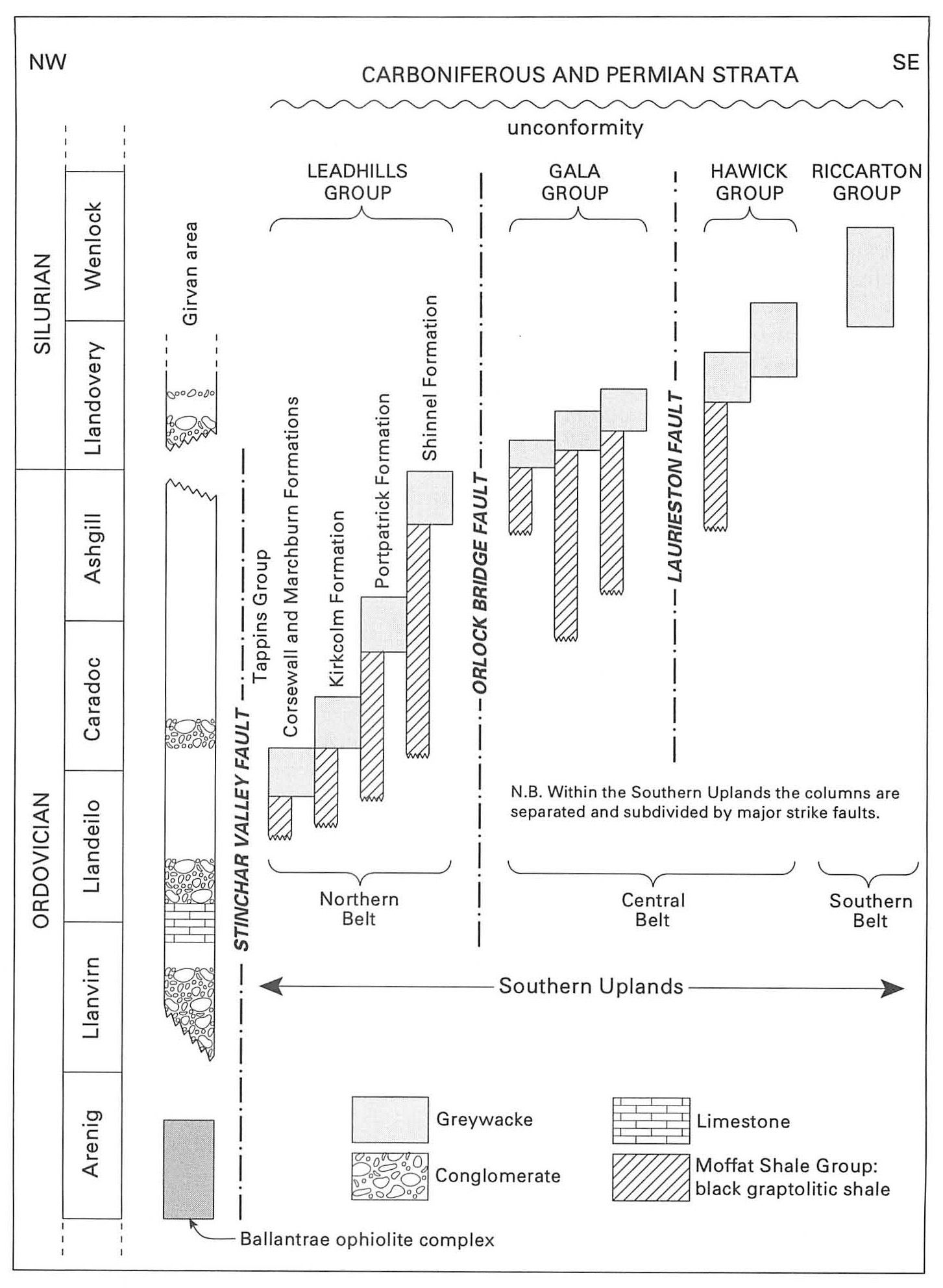
Introduction
During a day's excursion many aspects of Southern Uplands geology can be seen in the well-exposed coast sections around Rockcliffe on the Solway shore. North of Rockcliffe there are good outcrops of the granodiorite margin of the Criffell–Dalbeattie plutonic complex (Phillips, 1956). These lie near the steeply dipping contact between the pluton and hornfelsed Lower Palaeozoic strata of the
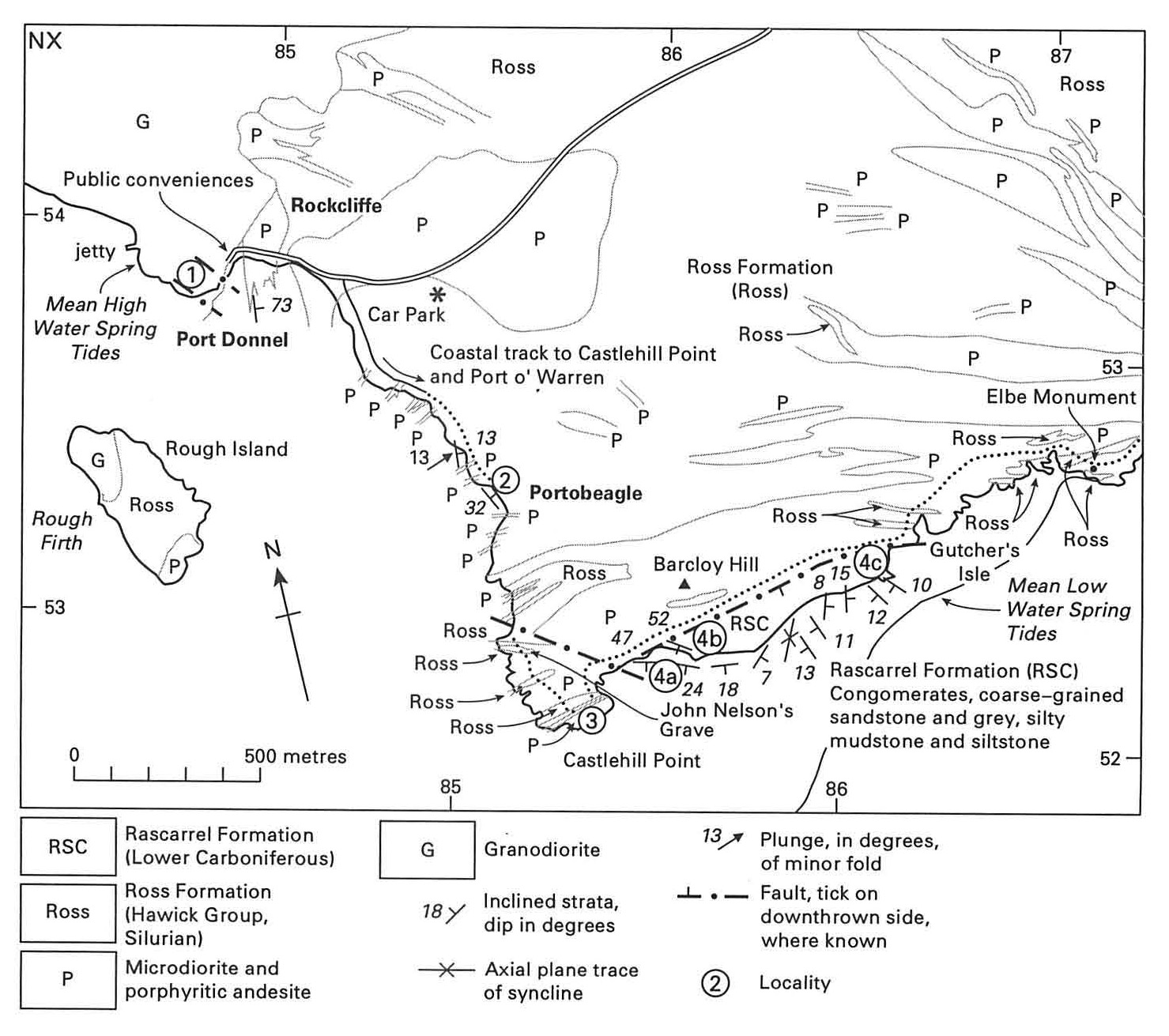
1 Port Donnel: granodiorite and porphyritic andesite
From the car park walk westwards on the road around Rockcliffe Bay, noting the use of the local grey Criffell granodiorite in some of the stone-built cottages. Large blocks of the rock with fresh surfaces, probably from Dalbeattie, have been used on the foreshore as sea defence. The rock is coarse grained and composed of white plagioclase feldspar accompanied by dark biotite and amphibole. There are numerous dark rounded xenoliths, of a few centimetres diameter; some are hornfelsed country rock (greywacke sandstone) and some are partially assimilated more basic igneous rocks such as quartz diorite. The granodiorite is cut by pale aplite veins, up to 3 cm wide, made of fine-grained quartz, orthoclase and plagioclase feldspar.
The sharp contact between hornfelsed sedimentary rocks and the granodiorite of the Criffell–Dalbeattie Pluton may be seen on the shore at Port Donnel
The granodiorite at Port Donnel is much reddened by haematite staining. It is coarse grained and locally exhibits a foliation picked out by the alignment of plagioclase crystals. Careful inspection of the outcrop reveals small, round dark grey xenoliths of country rock, best seen on wave-washed surfaces. Several small NW-trending faults form shattered and veined zones in the otherwise blocky granodiorite. Small movements on faults of this trend may have occurred intermittently over a long period stretching from early Devonian into Carboniferous times. Prominent joints, produced during the cooling of the pluton, are another feature of the rock.
2 Portobeagle Shore: Ross Formation
Walk back round Rockcliffe Bay and take the signposted coastal track which leads south to Castlehill Point. Between the village and the point there is almost continuous coastal exposure of greywacke turbidites of the
The greywackes are generally medium to thickly bedded and are calcareous. Typically they are medium-to fine-grained sandstones and are interbedded with grey silty mudstone. Elsewhere, biostratigraphical evidence from graptolites in interbedded shales places the
In contrast to the regional NE strike of Lower Palaeozoic strata, many bedding planes at this locality dip at low angles to the NE. This is because the beds have been folded about fold hinges plunging gently to the NW or SE. There is plenty of evidence for the strata being the right way up; prominent graded bedding and superb examples of ripple crests on upper surfaces of the turbidite units are notable features.
Zones of brecciation and shearing are common, as are numerous east-and NE-trending porphyritic andesite dykes which cut the sedimentary rocks. Some of the dykes are also brecciated.
3 Castlehill Point: viewpoint
From Portobeagle ascend the coastal path past John Nelson's grave, skirting the grazing field to Castlehill Point. Castlehill is the site of an ancient Fort, thought to have been occupied intermittently from about 400 BC until early mediaeval times. Pottery of mediaeval date found here is curated in Dumfries Museum. The viewpoint indicator highlights some of the places visible on a clear day and it is worth spending a few minutes attaching some geology to the scene. To the north, some 5 miles (8 km) away, lies Screel Hill (343 m), composed of hornfelsed, and therefore durable, greywackes. The hill lies within the aureole of the Bengairn quartz diorite intrusion, a part of the Criffell–Dalbeattie complex. To the west, Rough Island, Almorness Point and Heston Isle all comprise
Southwards some 24 miles (38 km) across the Solway Firth, St Bees Head is formed of Triassic St Bees Sandstone. Thirty miles (48 km) away to the SE Skiddaw (930 m), composed of Ordovician
The spectacular cliff immediately to the NE of Castlehill Point is the fault scarp of the North Solway Fault. This forms the abrupt northern boundary of the Upper Palaeozoic Solway Basin, separating Lower Carboniferous strata on the shore from Lower Palaeozoic turbidites intruded by Silurian-Devonian porphyritic andesites in the cliff.
4 Shore section from Castlehill Point to Gutcher's Isle: Rascarrel Formation
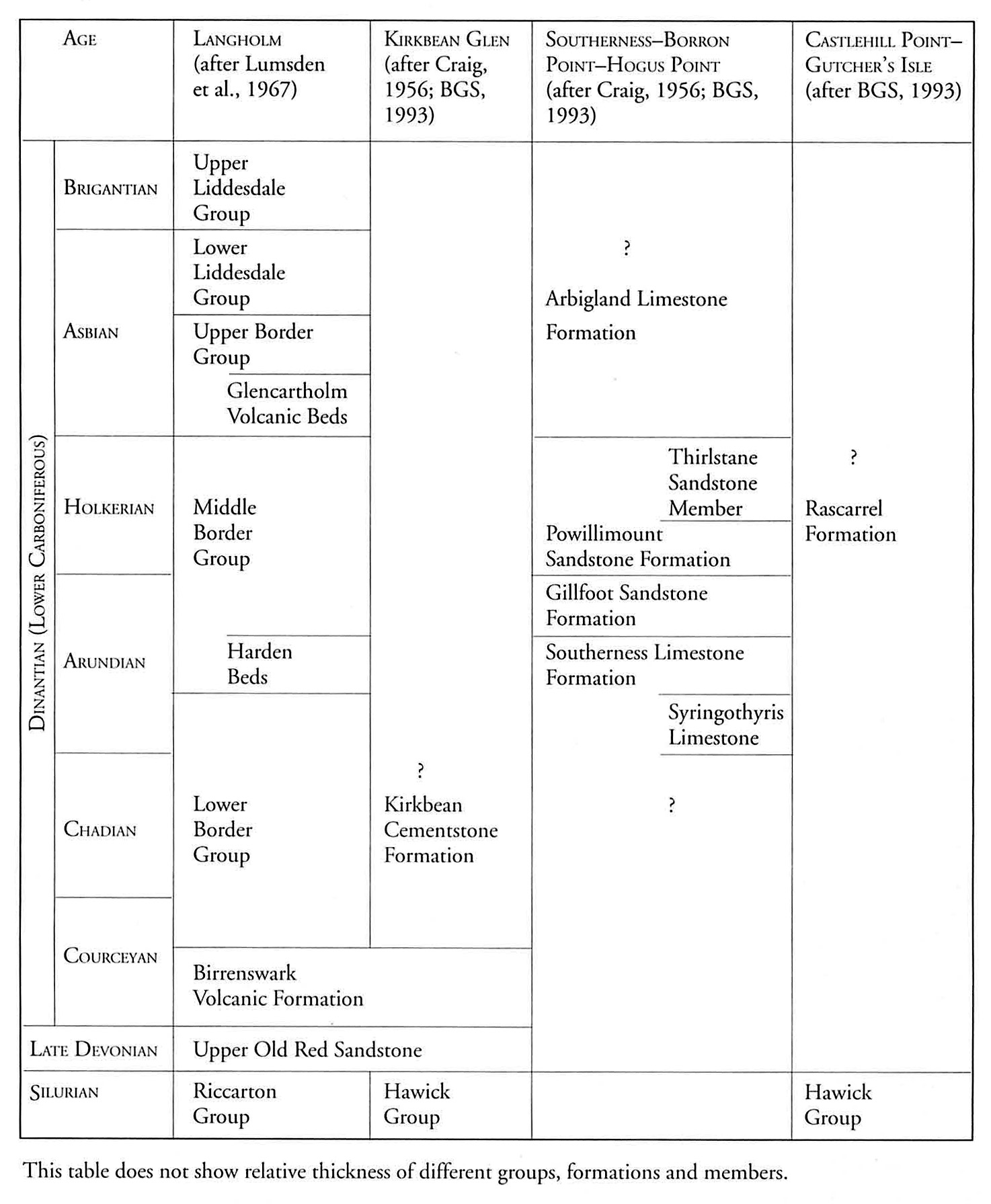
Locality 4a Walk down the steep path to the shore and across the shingle to the fault scarp. It represents a faulted unconformity and is formed of a carbonate-cemented fault breccia; the blocks and fragments are mainly of reddened porphyritic andesite, with some greywacke and mudstone. From here, Lower Carboniferous strata are exposed for 1.2 km eastwards along the shore. The section is rocky and can be properly examined only at low tide. The dip is generally to the south and decreases from about 50· within 10m of the fault to less than 15° over a distance of 30 m seawards. The basal strata are conglomerates, rich in clasts of porphyritic andesite and granite. These pass into arkosic sandstones and dark grey laminated siltstones and mudstones (Deegan, 1973; Craig and Nairn, 1956). Some of the sandstones and finer-grained rocks contain marine fossils. All these beds have been assigned to the Rascarrel Formation (BGS, 1993a). Deegan (1973) interpreted the conglomerates and coarse-grained sandstones as the deposits of alluvial fans which passed laterally and upwards into shallow-marine sediments. Rapid lithological variations of this nature may be attributed to intermittent movement on the basin-margin fault and/or external factors affecting sea level. Some of the steeply dipping strata nearest the fault contain liquefaction structures and extensional faults interpreted by Ord et al. (1988) as the effects of seismicity on unlithified or semilithified sandstones.
Locality 4b On the shore between Barcloy Hill and Gutcher's Isle, at the east end of the Carboniferous outcrop, there are a number of fossiliferous horizons. In the intertidal zone
At the east end of the sandy bay at Gutcher's Isle
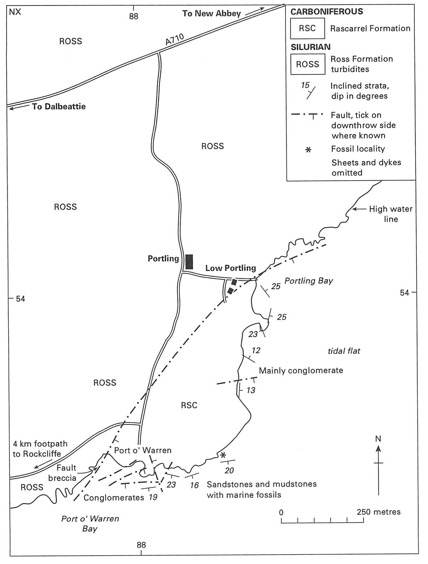
5 Portling Bay: Rascarrel Formation
The excursion can be completed at Gutcher's Isle and the route retraced to Rockcliffe, using the coastal path around the south side of Barcloy Hill. However, the excursion may be extended eastwards via the coastal path which eventually leads to Port O' Warren
Seaward of the path are good exposures of
Walk to Port O' Warren and take the narrow road to Portling. If time and tide permit, the shore section at Portling Bay, accessed by the lane leading from Portling to Low Ponling, is worth a visit. Strata of the Rascarrel Formation are exposed between Portling Bay and Port O' Warren Bay. The strata were described by Deegan (1973). As in the Castlehill Point-Gutcher's Isle section, a lower sequence of conglomeratic alluvial fan deposits passes up into fossiliferous dark grey shales and sandstones. Thin limestones, cornstones and cementstones are also present. Craig and Nairn (1956) recorded the following marine fauna, dominated by nautiloids, from a shale near the top of the sequence (position shown by asterisk on