Show interactive timeline
Excursion 8 Girvan and Ballantrae: an obducted ophiolite
By P. Stone
OS 1: 50 000 Sheet 76 Girvan
BGS 1: 50 000 Sheet 7 Girvan, 8W Carrick and 14W Ayr
BGS 1: 25 000 Sheet IVX08, 18 and 19 (in part)
Route maps:
Main points of interest Early Ordovician Ballantrae ophiolite Complex (pillow lavas, gabbro, serpentinite, chert and melange), late Ordovician and early Silurian greywacke and conglomerate; late Ordovician reef limestone, Caledonian folding.
Logistics There is ample parking for cars and space for a coach near most localities. Most of the exposures are on the coast and require much scrambling over steep and sometimes slippery rocks. Maximum walk at any one locality is about 2.5 km along beach and cliff paths. The outcrops are best seen at low tide and ideally the excursion should be planned to coincide with low water at about 1pm; this should allow adequate access from 9am to 5pm. Most of the localities described have been designated Sites of Special Scientific Interest (Appendix 2).
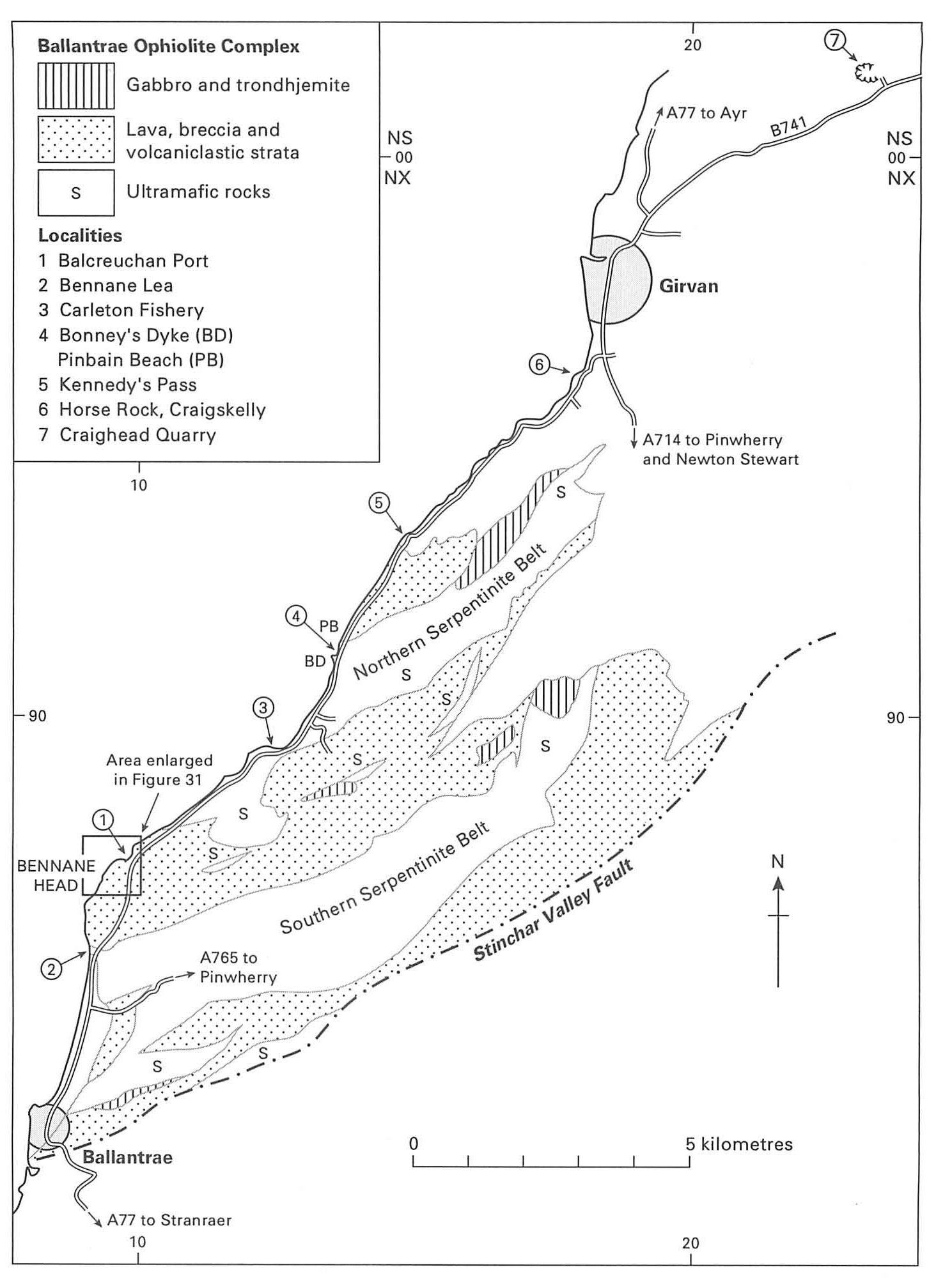
Introduction The ophiolitic Ballantrae Complex and its sedimentary cover are well exposed between Girvan and Ballantrae. The area has been a focus of considerable geological research (summarised by Stone and Smellie, 1988). The geological complexity of the area is such that several days are required to examine all of the varied features exposed. Thus, previous excursion guides have included a three-day itinerary (Robertson et al., 1990) and the seven itineraries recently published by Bluck and Ingham (1992). The field excursion described below is intended to bring out the main features of the complex and its unconformable sedimentary cover in a single day. Those with more time available are referred particularly to Bluck and Ingham (1992).
The ophiolite complex consists of two main elements interleaved by faulting; serpentinised ultramafic rocks representing oceanic mantle and volcanic sequences representing the remains of island arc and ocean crust. The structure is dominated by NE–SW faults which divide the complex into discrete lithological zones such that northern and southern serpentinite belts separate three areas of mainly volcanic rock
The ophiolite complex is examined at Localities 1 to 4, and the sedimentary cover at Localities 5 to 7. Locality 7 should be regarded as an alternative stop in a single day excursion but could be included in a more leisurely 2-day schedule. Since many of the coastal exposures are tide-dependent (local details given below) the order in which localities are visited may have to be varied to suit conditions. Tide tables should be carefully checked and the excursion planned accordingly.
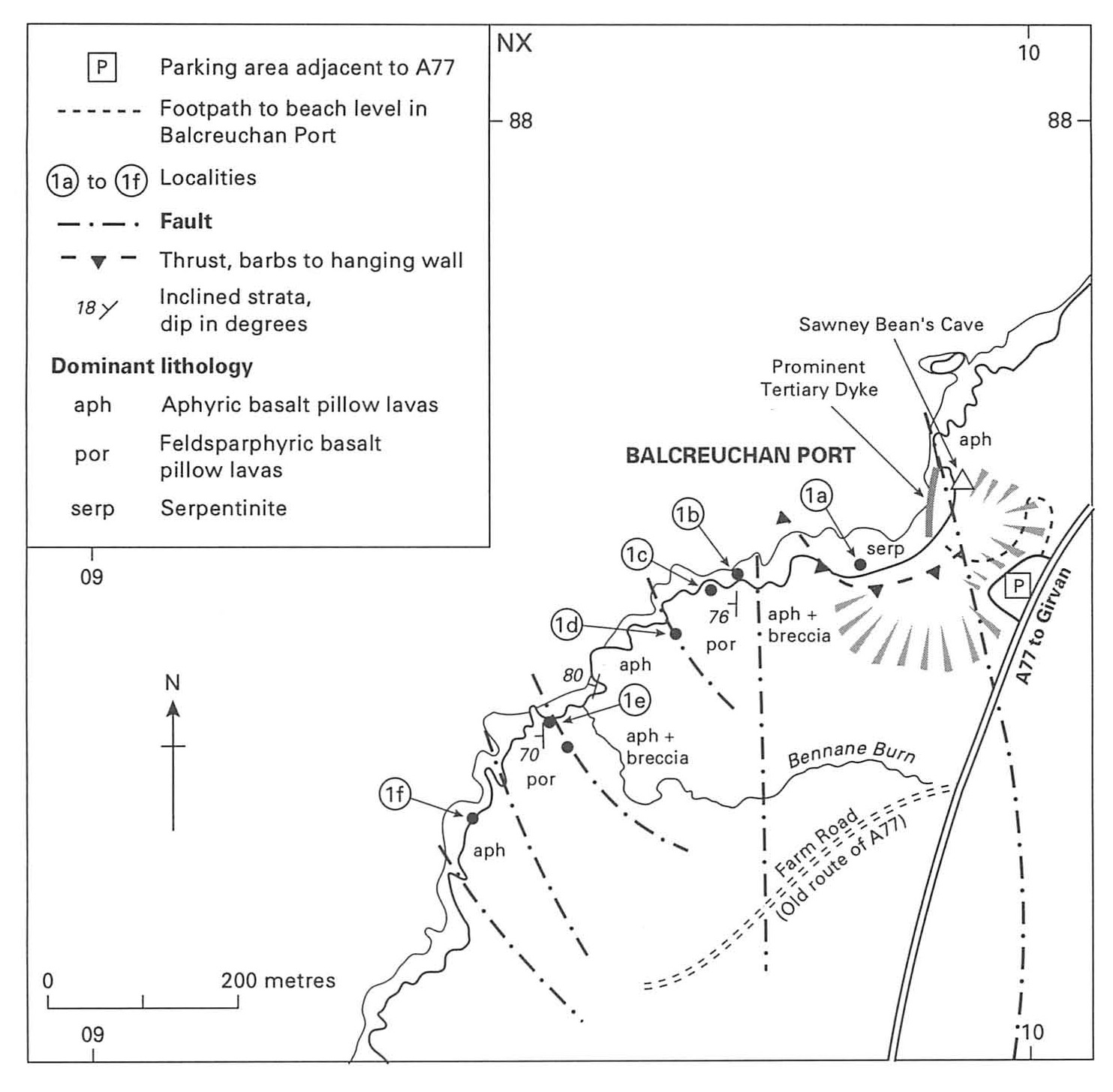
1 Balcreuchan Port: structural imbrication in Arenig lavas and lava breccias
A convenient place to begin the excursion is the large lay-by overlooking Balcreuchan Port on the seaward side of the A77
From the car park descend into Balcreuchan Port by the steep footpath on the east side of the cove. Take great care, the slopes are very steep so do not leave the foot path. However, note the cliffs to the south and east; pillows of basalt lava can be seen on both sides.
At beach level there is extensive intertidal rock outcrop. Prominent here is a Tertiary basalt dyke, up to about 50 cm across and trending generally north across the foreshore. The dyke has resisted erosion and now stands proud of its host rock. Abundant amygdales are concentrated into zones parallel to the dyke margin and are normally restricted to only one side of the dyke.
The Tertiary dyke is intruded into highly altered ultramafic rock which at this locality consists largely of a mass of secondary quartz and carbonate veins. Such alteration is fairly common at the margins of serpentinised ultramafic bodies and is generally regarded as a side effect of the serpentinisation process. A north–south fault marks the east margin of Balcreuchan Port, beyond which the steep sea cliffs are formed by basalt lavas, both massive and pillowed. The petrographical and geochemical characteristics of the volcanic rocks are typical of lavas erupted in oceanic island arcs above subduction zones (Thirlwall and Bluck, 1984; Smellie and Stone, 1988 and references therein). Most of the sequence is tholeiitic but it includes some boninitic lavas with exceptionally high contents of Cr and Ni. This lava variety is relatively rare and modern examples are found exclusively in oceanic island arcs (Smellie and Stone, 1992). Within the lava sequence a cave, controlled by minor faulting, is reputed to have been the home of Sawney Bean and his family, the notorious 16th century cannibals.
From the cave and the adjacent boninitic lavas cross SW towards the opposite side of the bay. About two-thirds of the way across (1a on
Rejoin the footpath above these crags and continue west for a few metres to the next prominent outcrop. This is formed of reddened basaltic pillow lavas rich in feldspar phenocrysts and, at the east side of the outcrop, a conformable relationship can be established between the lava and fine-grained sandstone. Bearing in mind the younging direction established earlier, the lava almost certainly overlies the sandstone. These lavas, and those to be examined subsequently towards Port Vad and Bennane Head, have the geochemical characteristics of oceanic island or hot-spot lavas similar to the modern example of Hawaii. Such a major change in lava type emphasises the importance of the fault to the east of locality 1b.
For the next few tens of metres westward the feldsparphyric pillow lavas are well exposed, particularly on the flat surfaces overlooking the sea. An approximate north–south strike of steeply inclined bedding can be readily established, and a continuation of the westward younging confirmed, from the shape of the pillows. These have smooth convex upper surfaces but more irregular lower surfaces which bulge and drape into underlying cavities. Note the red chert filling spaces between some of the pillows. The feldsparphyric pillow lavas are exposed on the next rocky headland (1c) but there they are cut by dykes of fine-grained basalt, best seen on the seaward end of the headland. The dykes are taken to be feeders for the next higher unit of pillow lavas because these have the same aphyric composition.
The contact between the two lava types is exposed in a fault gully about 15 m farther west (1d). A deep cleft is open to the sea but at the narrower, inland end the rock in the gully walls can he examined. Take great care; the sea is a long way down and the exposure is precarious. The eastern side of the gully is formed of feldsparphyric lava and the lowermost pillows in the western wall are also feldsparphyric. However, these are conformably overlain by aphyric pillow lavas, which then form the sequence continuing westward.
Continue west on the footpath, crossing faulted and brecciated aphyric lavas, towards the mouth of the Bennane Burn. Stratified, fine-grained elastic rocks overlying the brecciated lavas, are best examined beside a sea-water pool on the SW side of the burn (1e). Interbedded sandstone, chert and dark shale form a small cliff; the shale has yielded graptolites of middle Arenig age (Stone and Rushton, 1983). Thus, the traverse has passed from the lower to the middle Arenig, confirming the sedimentological evidence for westward younging.
From the sea-water pool climb inland for a short distance up a cattle track into a shallow NW–SE gully with rock forming low crags along its SW side. These crags expose a familiar sequence: reddened feldsparphyric pillow lavas conformably overlie fine-grained elastic strata including a red and cream striped sandstone remarkably similar to the early Arenig example seen at Locality (1b). The feldsparphyric lavas are well exposed to the SW and pro-vide abundant evidence of continued and consistent steep dip and SW-younging. Cheri and siliceous sandstone interbeds occur at intervals and from one of these an early Arenig graptolite fauna has been collected (Stone and Rushton, 1983). The comparison with the sequence traversed at Localities 1b to 1d is then further strengthened by the appearance of aphyric pillow lavas above and to the SW of the feldsparphyric pillows. The aphyric pillows are well exposed in landward-facing cliffs at the margin of a small embayment about 200 m SW from Bennane Burn (1f) but from there the coastal cliffs become impassable. A major fault repeating the succession seems probable and the most likely site is the NW–SE gully followed by the cattle track at Locality le above Bennane Burn.
Return to the car park above Balcreuchan Port and proceed to Locality 2, where the southward continuation of the section can be seen.
2 Bennane Lea: Balcreuchan Group (Arenig) conglomerate and chert
South from Balcreuchan Port the A77 has been re-routed inland for about 2 km to Bennane Lea. Some parking space is available on the seaward side of the road where it rejoins the coast and the extensive raised beach
Exposures of Permian red sandstone beds, dipping gently south, can be examined at low tide. These lie at the edge of an extensive offshore Permian basin, the faulted eastern margin of which runs beneath the raised beach between Bennane Lea and Ballantrae. However, locally at Bennane Lea the Permian strata are unconformable on the Ballantrae Complex and the basal red sandstone contains clasts of spilitic lava (Stone, 1988).
There is a marked topographical change at Bennane Lea: steep sea cliffs to the north contrast with the raised beach, backed by relic sea cliffs cut in glacial till, to the south. The change takes place across a faulted junction between basaltic lava and breccia, to the north, and less-resistant ultramafic rock of the Southern Serpentinite Belt, to the south. The ultramafic rock exposed on the shore is altered and reddened, it also contains pods of gabbroic composition which are probably tectonic inclusions. The fault itself is exposed on the foreshore at Bennane Lea (subject to the vagaries of drifting sand) as a thin zone of silicification, north of which a massive tuff unit forms the first rocky outcrop. Traversing northwards a conformable contact between the tuff and underlying thinly bedded cherts can be seen. The cherts themselves contain altered radiolaria and are chaotically deformed into small-scale, disharmonic structures which seem most likely to be the result of soft sediment deformation through slumping. Slightly farther north, mass-flow conglomerates are interbedded with the cherts; the pebbles and cobbles present are mainly of spilitic lava and all can be related to lithologies exposed elsewhere in the Ballantrae Complex. Pale blocks, seemingly of limestone, at first appear out of place but contained chrome spinel grains suggest that they are likely to have originated as ultramafic rock. Alternations of bedded chert and conglomerate continue north for about 100 m, folded about several large, upright hinges which plunge steeply seawards. These are tectonic structures and can be correlated with the large anticlines and synclines clearly visible in the steep cliffs on the inland side of the old A77 road. The steep hinge plunges may bring down to the beach exposures the highest stratigraphical levels preserved, i.e. the mass flow conglomerates which are certainly not present in any of the inland outcrops.
Farther along, to the north of Bennane Cave, discontinuous layers of coarse feldspathic sandstone are interbedded with the chert. At one important exposure
North towards Bennane Head the rock exposed at sea level for the first few hundred metres is predominantly basalt lava but the cliffs inland of the old A77 consist mainly of basalt breccia which extends seaward to form the steep cliffs of Bennane Head itself. The breccia is believed to overlie the middle Arenig sequence seen at Locality le (Stone and Smellie, 1988, table 5). It can be most readily examined by continuing north for about 300 m to the southern flanks of Bennane Head
3 Carleton Fishery: ultramafic rock and altered dolerite
The next locality, Carleton Fishery, is about 5 km north along the A77. Ample parking is available in the well-signposted picnic site
The outcrop is within the Northern Serpentinite Belt and ultramafic rock, mainly dunite, is exposed between the loose boulders and shingle. Locally, layered relationships on a centimetre scale are developed between the dunite and coarser-grained, pyroxene-rich harzburgite. The main mass of the outcrop is composed of dolerite, which was probably originally intrusive into the dunite. It has suffered extensive calcium metasomatism and this has produced the fine-grained, flinty appearance of the marginal dolerite which is now composed of an assemblage of calcium-rich secondary minerals (e.g. prehnite, pectolite, hydrogrossular) known as rodingite. Large relict feldspar phenocrysts can be seen in some parts of the dolerite, and a large ultramafic enclave forms an eroded hollow on the top of the main rock mass. Another feature of interest is the network of thin (< 1.5 mm) chrysotile asbestos veins, seen in the ultramafic rock towards low water mark on the north side of the outcrop. The veins are mostly developed adjacent to the dolerite and parallel to its margins. Return to the parking area at the Carleton Fishery picnic site.
4 Bonney's Dyke and Pinbain Beach: gabbro pegmatite, Balcreuchan Group melange and breccia
About 2.5 km north from Carleton Fishery is a locality known as 'Bonney's Dyke'. Parking is available in a rough lay-by on the seaward side of the A77
Bonney's Dyke is a term used in the geological literature for a mass of pegmatitic gabbro within the Northern Serpentinite Belt. The name derives from Professor T G Bonney, the eminent Victorian mineralogist who recognised the igneous origins of much of the Ballantrae Complex (Bonney, 1878). When approached from the south the gabbro stands out as a paler, more resistant body within the ultramafic rock. It is exposed just above high water mark and in the intertidal zone. The outcrop is slightly arcuate owing to the cumulative effect of minor sinistral wrench faults. The pegmatitic texture is spectacular, with plagioclase and altered clinopyroxene crystals up to 3 cm across within zones of marked grain-size variation. There is no sign of chilling against either the surrounding ultramafic rock or the numerous serpentinite xenoliths. Three types of marginal contact relationship are seen:
- sharp gabbro-serpentinite contacts;
- less well-defined margins where the gabbro is in contact with coarse pyroxenite veins;
- sheared margins that are fine grained, flinty and particularly intensively Ca-metasomatised (rodingitised).
The south side of Bonney's Dyke shows a combination of types 1 and 2 whereas the north side is principally a sheared contact of type 3.
Pyroxenite veins occur intermittently throughout the ultramafic outcrop; they are pale green, coarse grained and up to about 50 cm across. The coarsest developments contain pyroxene crystals several centimetres across and can be seen slightly to the south of the gabbro towards low water mark.
From Bonney's Dyke walk north along the shore for about 350 m towards Pinbain Bridge. Several low intertidal outcrops expose fine-grained serpentinised harzburgite, although the movement of the beach sands may occasionally obscure them. Alternatively, drive up to a small lay-by on the seaward side of the road at Pinbain Bridge
The highest point within this sequence of rocky outcrops consists of brecciated spilitic pillow lavas. Many of the pillows retain their shape despite pervasive cracks but others have completely disaggregated. There is no fine-grained matrix with this deposit and it is uncertain whether it forms a discrete unit interbedded with the mélange or whether it is part of a very large clast contained within the mélange. The latter lithology is also exposed to the north of the breccia but there the proportion of clasts is higher, and the foliation less marked, than in the exposure to the south.
Farther north a complex fault zone reintroduces tectonic slivers of serpentinite into the section. These are not exposed at beach level but form the cliff behind the isolated raised beach inland of the A77 where some dunite contains large pods of chrome spinet. The main mass of steep cliffs and rocky coastal outcrop to the north is composed of volcaniclastic sandstone, the faulted contact with the serpentinite slivers being intruded by Tertiary dykes. These are exposed at beach level immediately south of the sandstones. The latter are at the base of a thick sequence of lavas and elastic sedimentary rock which is exposed continuously for some distance north along the coast. Graptolites have been recovered at the base of the sequence from siltstones which are exposed on the inland roadside of the A77 behind the crash barriers. An early Arenig age was deduced by Rushton et al. (1986) but the specimens are generally fragmentary, very scarce, and only recovered with much patient effort.
5 Kennedy's Pass: Caradocian Kilranny Conglomerate and Ardwell Formation
Drive about 2.5 km north from Pinbain to Kennedy's Pass. Ample parking is available in a lay-by on the seaward side of the road
This locality allows examination of some of the late Ordovician strata which form an unconformable cover to the Ballantrae ophiolite. It is also described in an extensive field itinerary for the cover sequence given in Block and Ingham (1992). The full cover sequence records north-westward marine transgression, from the late Llanvirn onwards, across the obducted ophiolite. Sedimentation was controlled by a series of faults throwing down to the south but becoming sequentially younger to the north. The overall geometry is summarised in
At Kennedy's Pass the Kilranny Conglomerate is well exposed in the sea cliffs below the parking area. The
Overall the Kilranny Conglomerate is crudely stratified with both clast- and matrix-supported lithologies present. Some beds show clast imbrication and from this can be deduced a palaeocurrent flow from the north. Clasts range up to 1 m across and include red chert, basalt and gabbro (probably derived from the underlying ophiolite) and abundant felsitic and granitic rocks. Prominent amongst the latter are clasts of pink granite which have been dated by the Rb-Sr method at about
The conglomerate beds become younger northwards, and near the north end of the cliff exposure they are unconformably overlain by thinly bedded siltstones and greywackes of the Ardwell Formation. These are turbidites and appear to fill a channel eroded into the top of the underlying conglomerate. They are best examined about 100 m farther north where wave-polished surfaces reveal good examples of graded bedding and fine lamination. However, the most striking aspect of this section is the spectacular development of large and small chevron 'box' folds. Northwards from Kennedy's Pass the fold hinges trend approximately NE but plunge is variable; the southernmost examples plunge gently SW but, farther north, plunge passes through the horizontal and progressively steepens to about 45° NE. There is some controversy over the origin of these folds, which have been variously described as products of late Caledonian tectonism or as slump folds produced by the downslope movement of unconsolidated sediment: the former interpretation seems the most likely.
6 Cow Rock, Horse Rock and Craigskelly: contrasting early Llandovery conglomerates
Drive north from Kennedy's Pass for about 5 km to a large car park beside the beach on the southern outskirts of Girvan
From the car park walk south along the beach on the seaward side of the Ainslie Manor Nursing Home (formerly the Haven Hotel). This section also forms part of an extensive itinerary in Bluck and Ingham (1992). Outcrops between the beach and the Nursing Home consist of a coarse, mainly matrix-supported conglomerate containing abundant quartz pebbles and siltstone clasts, many quite angular. A small proportion of metamorphic lithologies is also present. The bed is known informally as the 'quartz conglomerate' and is stratigraphically a part of the Scart Grit. Southwards the number and size of siltstone clasts increases and at Cow Rock, NW of the Nursing Home, the base of the conglomerate can be seen (at low tide) to channel into an underlying siltstone and fine greywacke sequence. This is the
The
Palaeocurrent evidence, deduced from clast imbrication and bottom structures, indicates that the Craigskelly and quartz conglomerates were both derived from the NW. The cause of the abrupt change in character of the source terrane during the early Silurian is a matter of speculation.
Localities 1 to 6 will provide a full day's excursion and cover many points of interest within the Ballantrae Complex and its sedimentary cover. However, many of the exposures require examination at low tide and an inland site, Locality 7, is suggested as a partial alternative if the tides are unfavourable.
7 Craighead Quarry: Caradocian Reef Limestone
Craighead Quarry exposes Caradocian reef limestone overlying lavas of the Ballantrae Complex and is a Site of Special Scientific Interest for botanical as well as geological reasons. It is described as part of an extensive excursion itinerary for the Craighead Inlier in Bluck and Ingham (1992).
From Girvan drive north on the A77 towards Ayr and then turn right on to the B741 and continue for about 5 km. At Low Craighead Farm turn left; there is parking space for 3 or 4 cars in the entrance of the track leading to a disused quarry about 200 m beyond the farm on the left of the road
The quarry walls expose parts of a late Ordovician limestone reef assemblage (Craighead Limestone) stratigraphically equivalent to a level within the Ardwell Formation
References