Excursion 11 Dundrennan Ranges, Gipsy Point: Silurian submarine slump features
By E.N.K. Clarkson and C.M. Taylor
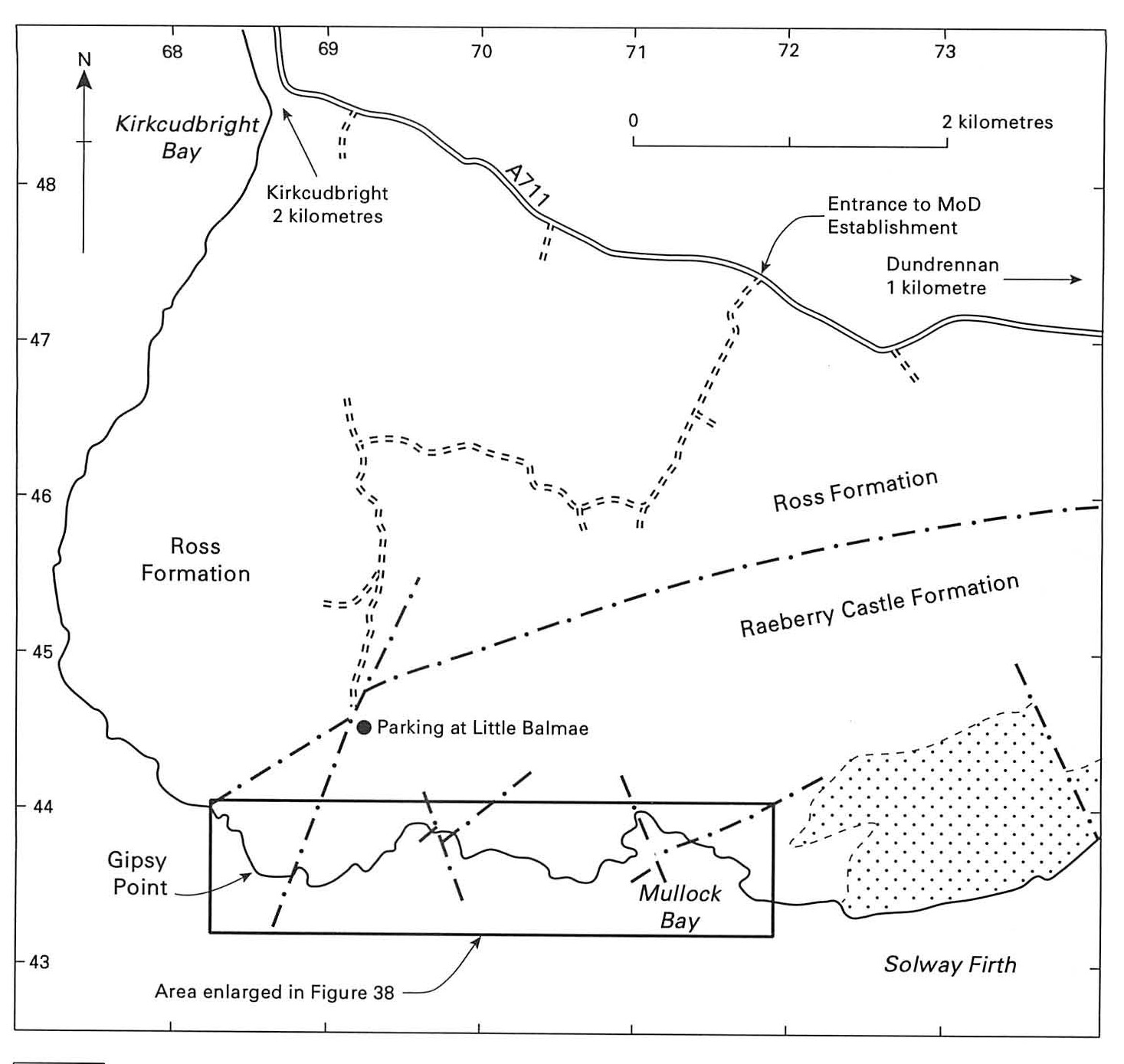
OS 1:50 000 Sheet 83 Newton Stewart & Kirkcudbright
BGS 1:50 000 Sheet 5W Kirkcudbright
Route maps:
Main points of interest Major slump structure, sand volcanoes and sedimentology of the
Logistics The area lies within the Ministry of Defence Test and Evaluation Establishment near Dundrennan, a strip of coastline which has been used as a firing range for many years. Recently announced plans (1994) indicate that its future is uncertain. The MOD has no objection to people visiting the area, except when firing is in progress! At such times red flags and explanatory notices are displayed. Notification of firing times is held by the Harbour Master and Tourist Information Office in Kirkcudbright. Access on foot is feasible without special permission when the range is not in use, normally evenings, weekends and public holidays, although it is always best to inform the range authorities in advance. Large parties, or visitors wishing to take vehicles into the range area, should contact the Commanding Officer beforehand (Test and Evaluation Establishment, Dundrennan, Kirkcudbright DG6 4QZ). Do not touch any strange objects encountered during the excursion.
Introduction
The primary aim of this excursion is to examine a gigantic slump structure, lying within a channel in a sequence of Wenlock turbidites belonging to the Gipsy Point Unit of the
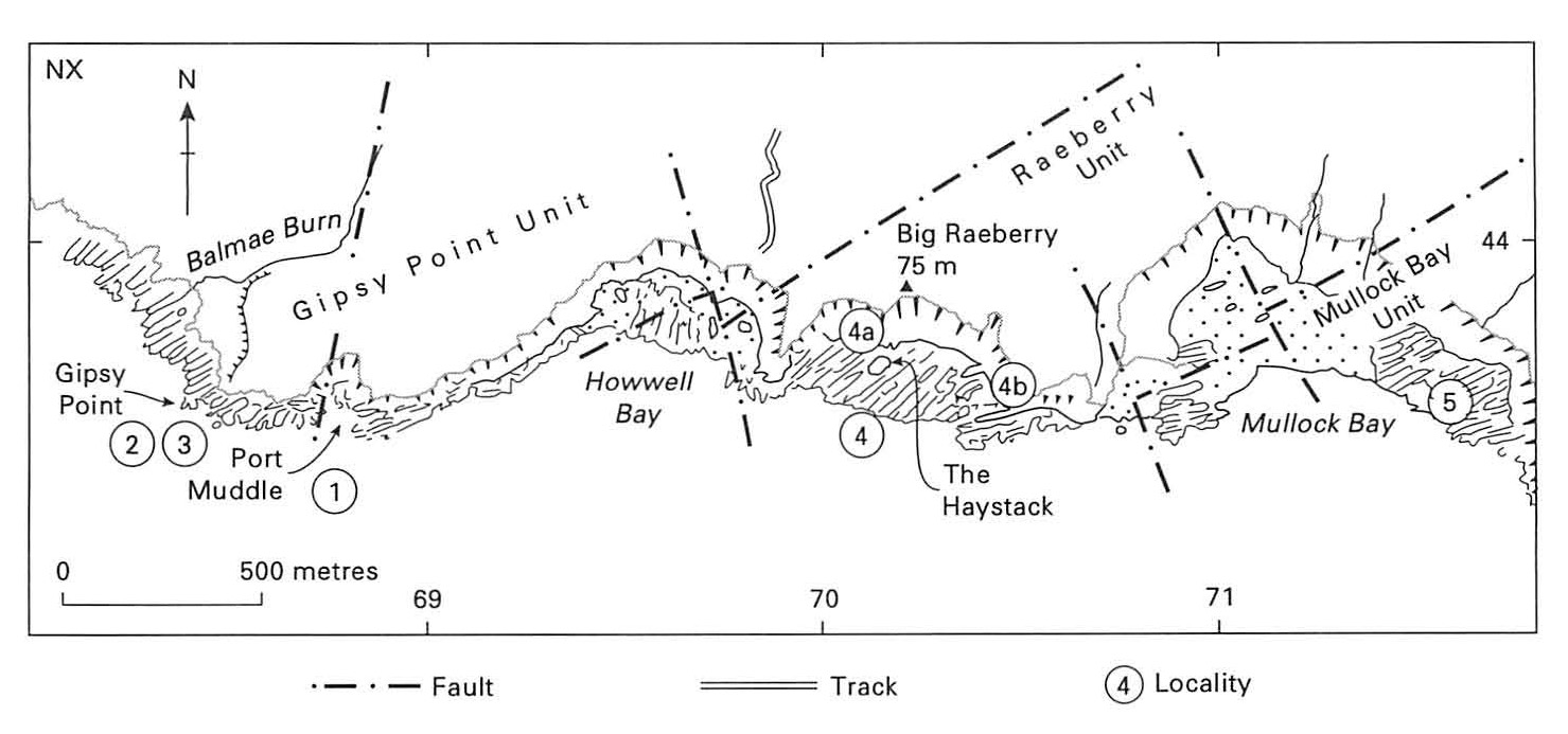
1 Port Muddle: Gipsy Point Unit
This bay is excavated at the seaward end of a fault trending NNE, which may be traced inland as a boggy depression. All the beds in this vicinity lie within the
According to Kemp (1987a and b), there are three definable tectonostratigraphical units within the
2 Gipsy Point: slump
A walk of some 300 m in a WSW direction, keeping the old tank to the left and crossing a ruined wall, brings the visitor to the cliff top at Gipsy Point
It is possible, with care, to descend to the coast from here, to examine the slump more closely. The erosive base of the slump (SE side) can be seen cutting into the underlying beds, forming fossilized channels with flute casts; in some places rip-up clasts can be seen in the mudstone. The whole sequence has been folded by a large anticline–syncline pair which traverses part of the section and is clearly seen as a large box-fold on the vertical face near the point of descent from the cliff top.
3 Gipsy Point: sand volcanoes
Directly overlying the large slump is a single layer (now vertical) of spectacular sand volcanoes, originally described by Lovell (1974), who suggested that they formed as a result of dewatering of the underlying slump. Above lies a coarsening-upward sequence of thin sandstone–mudstone layers, interpreted as an interchannel or overbank sequence. The sharp junction between the top of the slump, with its attendant sand volcanoes, and the overlying beds is very well seen in the cliff face. This shows clearly that the original channel had been abandoned by the time renewed deposition began.
Lovell identified ten sand volcanoes, occurring ill three groups, over 100 m of strike section. Five of these are easily accessible, even at mid-tide. The largest and most obvious is over 3 m across, and is almost completely preserved. It is about 1.5 m deep and has a depressed central crater nearly 0.5 m across. Several of the other volcanoes are cut across, showing laminated sandstone with complex internal structure, as if the water had escaped in a series of pulses. One small volcano directly overlies another smaller one. A thin sandstone bed connects the sand volcanoes of the landward and central groups, but does not extend to the seaward set. In this latter group, however, is a sand volcano, cut so as to display the central pipe, which in this case is filled with coarse sandstone. Stringers of gritty material have developed in the underlying sandstone, and penetrated upwards into the sediment overlying the volcano during the dewatering process. This example is the only one to show a direct connection between the beds above and below the volcano.
The thin sandstone beds of the overbank sequence directly overlying the sand-volcano horizon show some interesting sedimentary structures. Firstly there are ripple marks with slightly different orientations, seen on successive vertical faces near the cliff edge. Secondly there are other structures, well worth examining, on the lower surfaces of the thin sandstone units down on the shore, a few metres above the sand volcanoes. Some of these faces are smooth but show convolute lamination in cross-section; other surfaces display very fine load casts. In some instances an otherwise smooth surface has only one or two isolated load casts, of which some are simple, whereas others are grouped together like bunches of grapes. Many faces, however, are entirely covered with load casts. One surface, about a metre above the sand volcanoes, displays strings of clearly orientated load casts, suggestive of modified ripples.
Small dolomitised concretions can be seen within the slump close to the base of the cliff, and several small fault-planes within the vicinity are likewise dolomitised. These may possibly have been synsedimentary faults penetrated by the diagenetic fluids associated with the concretion-forming process.
4 Big Raeberry: Raeberry Unit
The section east from Gipsy Point to Mullock Bay shows many features of interest and should be visited if time permits. From the east side of Port Muddle, to the far side of Howwell Bay, underneath the prominent hill of Big Raeberry, the turbidites belong to the Raeberry Unit (rigidus to early flexilis biozones) of the
These distinctions are evident in the cliff section east of Big Raeberry, where the beds young to the NW. Just west of the prominent feature known as the Haystack
5 Mullock Bay: Mullock Bay Unit
About i km further east, excellent sections in the Mullock Bay Unit of the
Return to Port Muddle along the cliff top or the shore.