Excursion 18 Graptolites: Ordovician and Silurian biostratigraphy
By A.W.A. Rushton and S.P. Tunnicliff
By far the most commonly found fossils in the Lower Palaeozoic sequences of Southwest Scotland are graptolites. Unlike the Girvan area to the north, the region offers no localities where rich Shelly fossil assemblages can be found; but for the graptolite collector there is as wide a selection of fossiliferous horizons as anywhere in the British Isles, ranging in age from the Arenig to the Wenlock.
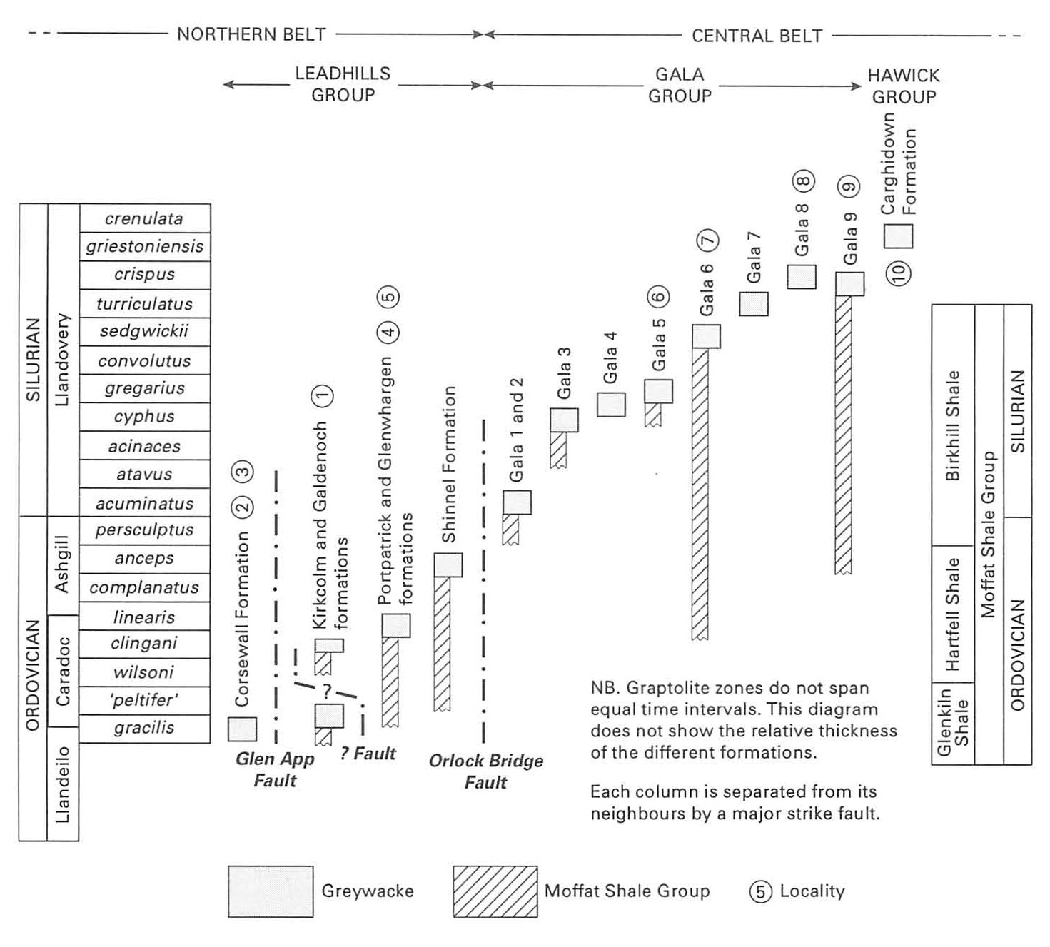
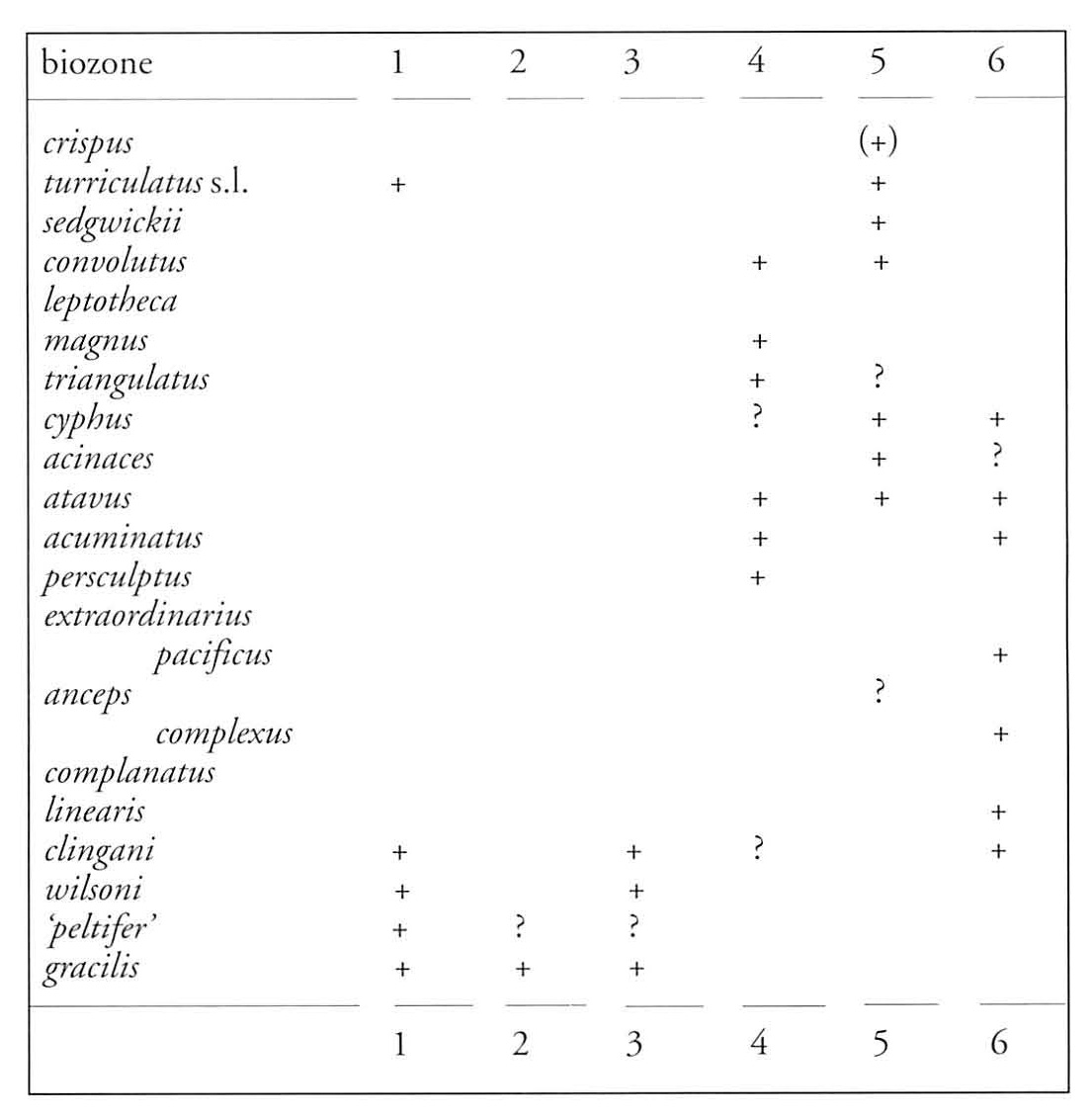
The collecting of fossils, especially the zonal collecting of graptolites, is not a task to be rushed. Time and perseverance are needed to locate the fossil-bearing layers, especially those with the best-preserved specimens, and a fair number of fossiliferous slabs are needed if a fully representative fauna is to be obtained. Most of the localities described here require a day's study (or longer) to do justice to their biostratigraphy, and in each there is every possibility that new discoveries will be made. The graptolite zones recorded so far from each of the localities are shown in
If planning a fossil-collecting excursion, note that the entry and parking should always be sought. General advice on the collecting of graptolites is given in Chapter 11 of Graptolites edited by Palmer and Rickards (1991).
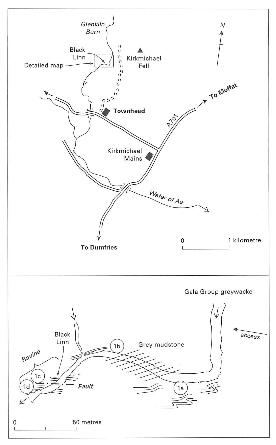
1 Glenkiln Burn [NY 007 895]
OS 1:50 000 Sheet 78 Nithsdale & Annandale
BGS 1:50 000 Sheet 10W Lochmaben
Route map:
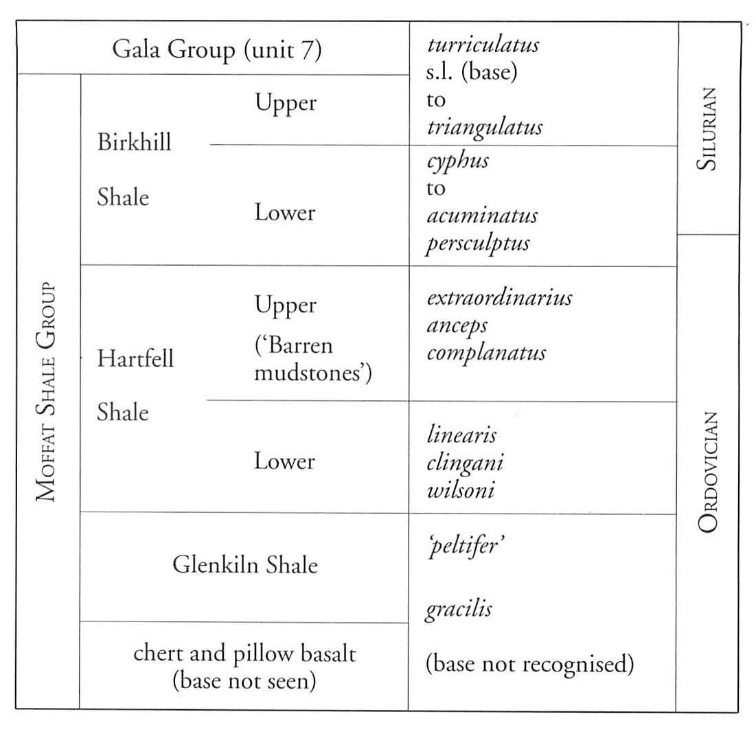
The exposures of Moffat Shale in the Black Linn section of Glenkiln Burn are historically important because they furnished Lapworth with one of his typical sections of their lowest unit, namely the Glenkiln Shales
Take the A701 (Dumfries–Moffat) road to Kirkmichael Mains, and then the turning to Ae Village. After 1.5 km there is limited roadside parking near the bridge west of the chapel at Townhead
Downstream of the bend, on the left (south) bank, is a bluff of Glenkiln Shales, deformed but locally fossiliferous (la). Hereabouts Lapworth's map shows an open shaft in the black shales where someone had 'foolishly excavated ... in search of coal' (Lapworth, 1878, p. 287). For about 50 m downstream the burn exposes unfossiliferous grey flaggy mudstones, but at the next left-hand bend, near the confluence of a tributary stream on the right bank, near-vertical fossiliferous black mudstones are seen striking approximately parallel to Black Linn (lb). Many strongly flattened graptolites of the Nemagraptus gracilis Biozone can be collected, including
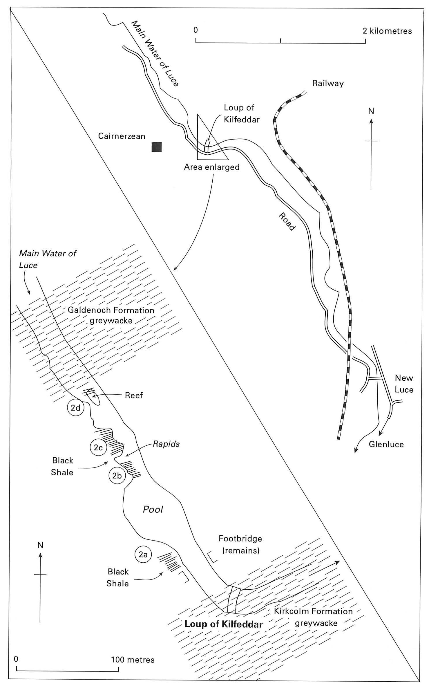
2 Loup of Kilfeddar [NX 152 674]
OS 1:50 000 Sheet 82 Stranraer; Glen Luce & surrounding area
BGS 1:50 000 sheets 1 and 3 The Rhins of Galloway
Route map:
The thick siliceous greywacke succession of the
From New Luce
At the broken footbridge, and just upstream of it, outcrops of black shale (2a) contain species of Cryptograptus, Dicellograptus, Dicranograptus, Didymograptus, Diplograptus, Glossograptus, 'Glyptograptus', Lasiograptus, Nemagraptus and Orthograptus. Some of the shales appear disturbed but in their midst are blocks of coherent shale with well-preserved graptolites.
Upstream the river broadens into a pool without exposure, but above this, where the river forms rapids, is a broad exposure of grey and black shale 15–20 m thick. Here the succession is interrupted by zones of disturbance (representing faulting and minor folding?) but graptolites including examples of Thamnograptus can be collected at places where the shale is less disturbed, for example near the downstream (2b) and upstream (2c) ends of the exposure.
Upstream of the rapids is a reef in the river where disturbed shales at the base of the overlying
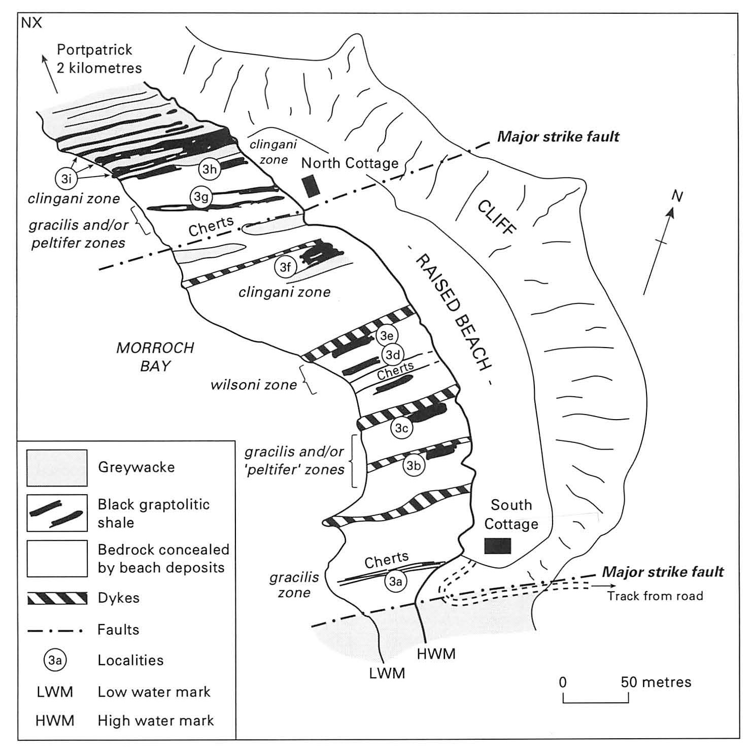
3 Morroch Bay [NX 017 525]
OS 1:50 000 Sheet 82 Stranraer, Glen Luce surrounding area
BGS 1:50 000 sheets 1 and 3 The Rhins of Galloway
Route map:
Morroch Bay displays the largest outcrop of the Moffat Shale in south-west Scotland. When the tide is out, mudstones and associated cherts of the Glenkiln and Lower Hartfell formations are exposed for nearly 400 m across strike and, at the north end of the bay, are interbedded with and overlain by the basal greywacke beds of the
If using a car, take the minor road from Portpatrick towards Knockinaam and Port of Spittal. About 3 km SE of Portpatrick [at
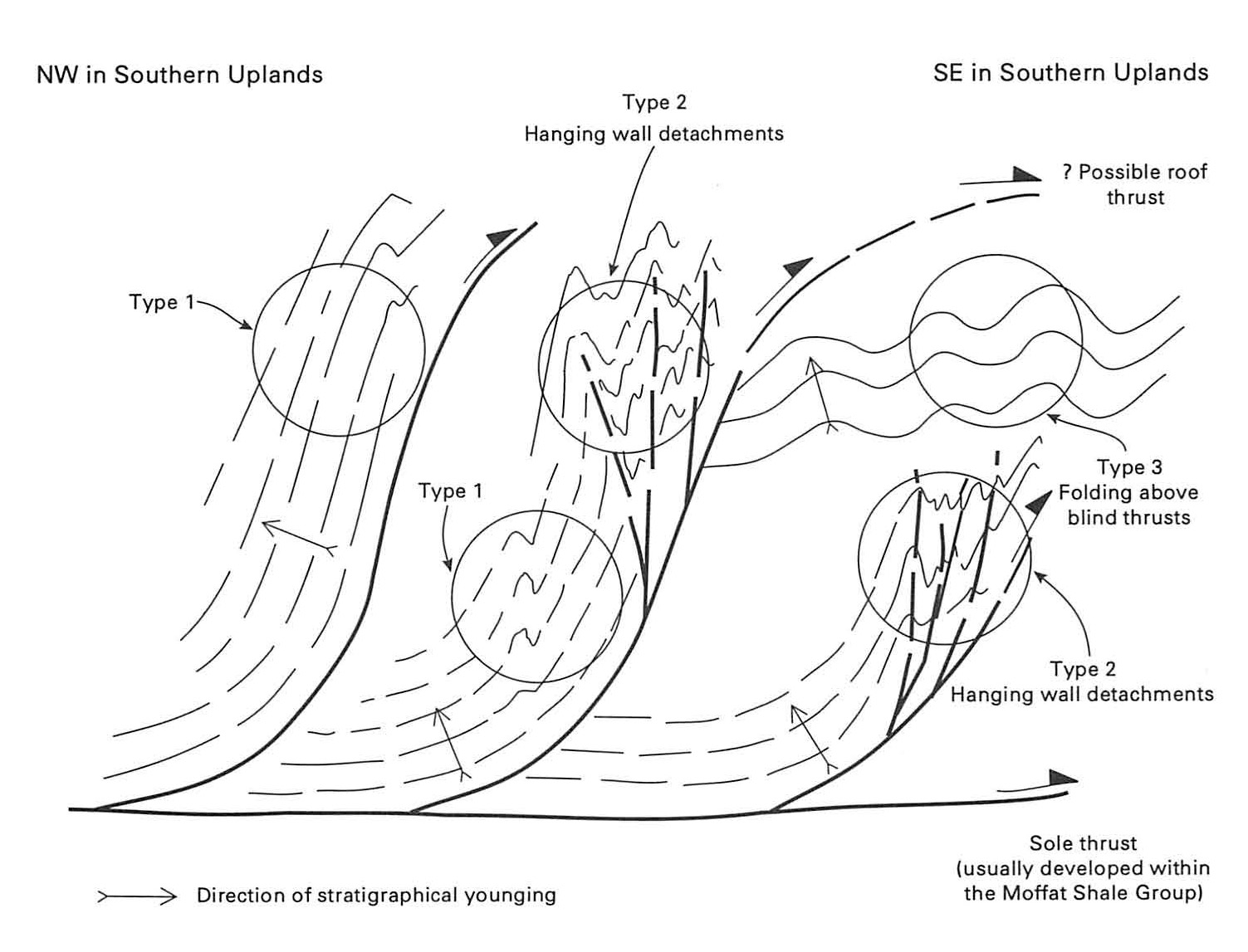
The intertidal zone exposes a thick sequence of mudstone dipping steeply and striking roughly SW, out to sea. There are several intrusive igneous dykes, more or less concordant with the bedding, and these can serve as useful landmarks when studying the mudstone succession. The mud-stones generally become younger from south to north but the distribution of fossil zones indicates at least one major structural repetition, whilst the anomalous thickness of some units, together with the presence of minor folding and faulting, shows that the structure is complicated in detail.
At the south end of the bay, black mud-stones (3a), associated with cherts and red and green mudstones have yielded a relatively diverse fauna of the N. gracilis Biozone, including a dozen species referable to
The succession to the north consists largely of red and green mudstones with beds of chert, but about 100 m north of the cottage at the south end of the bay (3b and 3c) you can collect faunas of the gracilis and possibly 'peltifer' biozones from black Glenkiln Shales.
The wilsoni Biozone is found in black shale (3d) about 150 m NW of the cottage, between chert beds and a large dyke near the middle of the bay.
Further north the mudstones are associated with some greywacke beds, and beside one of these (3f), about 50 m south of the northerly cottage, a fairly diverse D. clingani Biozone fauna can be found, with species of
The localities referred to so far are progressively younger northwards. However, a major strike fault to the north of here truncates the Hartfell Shale and reintroduces chert and Glenkiln Shale (3g) with fossils of the gracilis and 'peltifer' biozones.
The northern end of the bay shows very clearly the interbedding of black mudstone with the basal greywackes of the
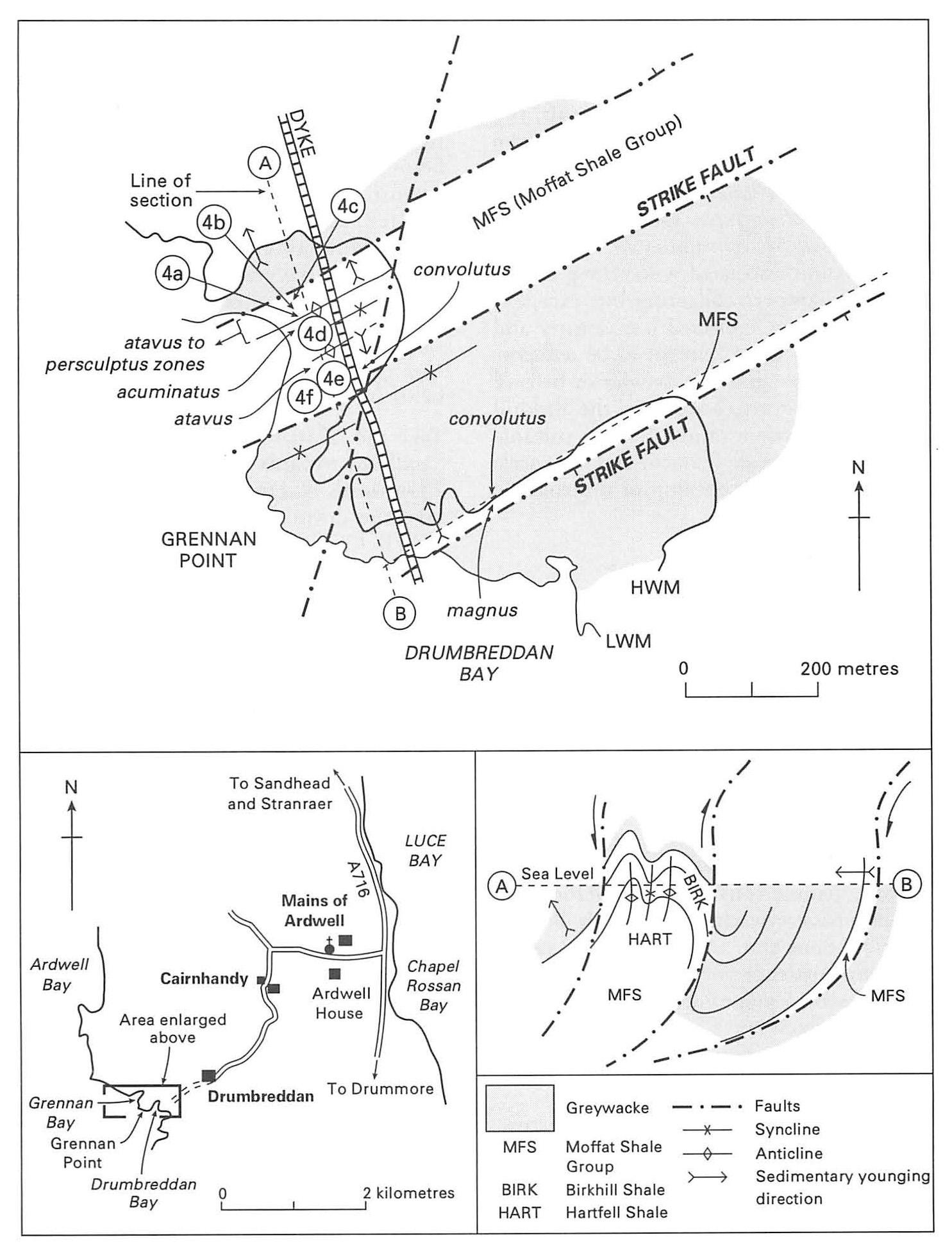
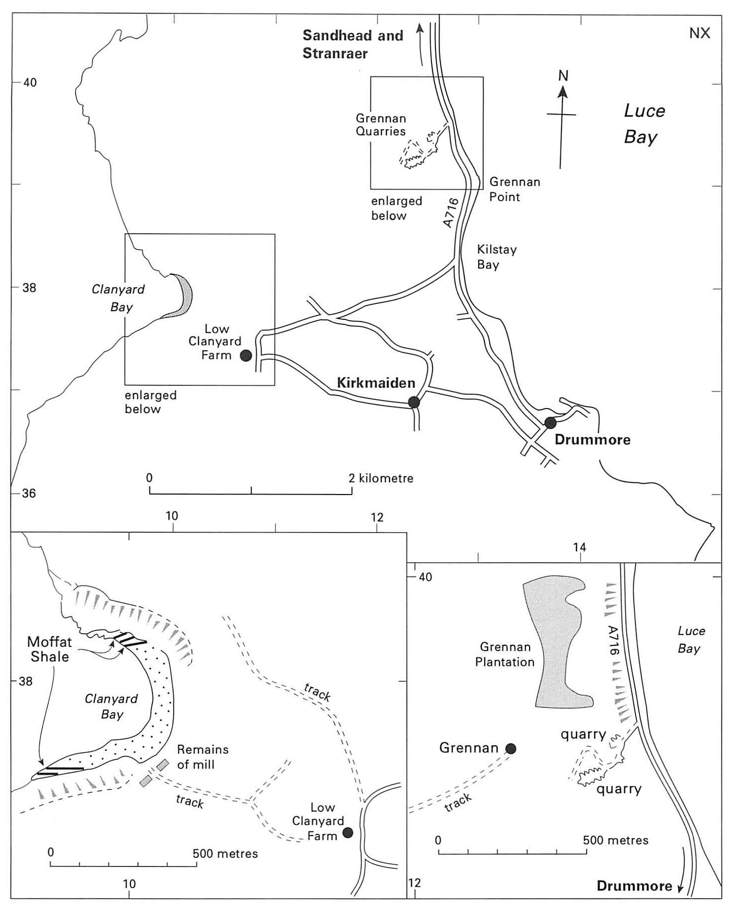
4 Grennan Point and Drumbreddan Bay [NX 075 437]
OS 1:50 000 Sheet 82 Stranraer, Glen Luce surrounding area
BGS 1:50 000 Sheets 1 and 3 The Rhins of Galloway
Route map:
Intertidal exposures around Grennan Point (about 13 km SE of Portpatrick) afford an opportunity to examine the Upper Hartfell Shale and several zones of the Birkhill Shale, and to see how they relate to the overlying greywackes of Grennan Point (
Approach on the A716 from Stranraer; 4 km south of Sandhead turn right, pass Ardwell House, and after 1.5 km turn left down the minor road to Drumbreddan
There are two principal exposures of Moffat Shale, separated by the greywacke beds that make up Grennan Point. The northerly exposure is much the larger and displays a wider range of strata; the southerly exposure shows the relationship with the greywacke particularly well. Structural aspects of this locality are described in Excursion 15.
North of Grennan Point (Grennan Bay)
The
Working north from the grey mud-stones, the first black beds encountered are basal Birkhill Shales (4b). Here you can collect fossils of the persculptus Biozone. Further to the north, 5 m from the faulted contact with the
Turning south from the pale barren mud-stones, the centre of Grennan Bay is occupied by a considerable thickness of Lower Birkhill Shale — massive black mudstones described by Lapworth as the vesiculosus Flags'. They yield fossils of the acuminatus Biozone in the centre of the bay (4d) and several species of the atavus Biozone (including species of Atavograptus, Coronograptus, Dimorphograptus and Normalograptus) within 10 m of the greywackes of Grennan Point (4e). Closer still to the greywackes (40, you can collect diverse faunas of the convolutus Zone, including species of Coronograptus, Glyptograptus, Petalolithus, Rhaphidograptus and several Monograptus species (Margutus, M. clingani, M. convolutus, M. limatulus). Deformation associated with strong nearby faulting hampers collecting but excellent specimens were collected last century and the source of those remains to be rediscovered. The pale greenish or whitish beds of soft claystone interbedded in the Birkhill Shale are metabentonites (altered volcanic ash). These indicate frequent and large-scale eruptions, but the position of the volcanic source is unknown.
Drumbreddan Bay
On the south side of Grennan Point a relatively narrow exposure of the Birkhill Shale (4g) extends along the base of the greywacke cliffs. Despite the presence of a strike fault, some of the graptolites found here are well preserved. Examples representing the cyphus Biozone? and the magnus Biozone have been recorded.
The Birkhill Shale passes up into a few metres of thinly bedded grey shale and laminated siltstone (4h) followed conformably by massive greywackes. The thinly bedded unit contains thin black mudstone seams and with patience you can collect rare but well-preserved graptolites of the convolutus Biozone which serve to date the onset of greywacke deposition.
5 Clanyard Bay and Grennan Quarries [NX 101 380]
OS 1:50 000 Sheet 82 Stranraer, Glen Luce ea surrounding area
BGS 1:50 000 sheets 1 and 3 The Rhins of Galloway
Route map:
The
Grennan Quarries, nearby, afford an opportunity to collect graptolites from interbeds in the greywacke succession and can be visited at times when the tide covers exposures in Clanyard Bay.
Clanyard Bay
Take the A716 south from Stranraer and Sandhead towards Drummore, but about 2 km north of Drummore
On the south side of the bay, the Birkhill Shale is exposed with associated beds of bentonite. Graptolites of the cyphus Biozone have been collected about 20 m from the base of the cliffs. Farther south, about 10 m from the cliff, the presence of the convolutus Biozone provides evidence for southward younging here.
Grennan Quarries
These quarries are situated just west of the A716, 3 km north of Drummore. One on the west of the track to Grennan [1267 3943] displays greywackes of
6 Gillespie Burn [NX 257 539]
OS 1:50 000 Sheet 82 Stranraer, Glen Luce & surrounding area
BGS 1:50 000 Sheet 4 W Kirkcowan
Route map:
Gillespie Burn exposes an interesting succession of Upper Hartfell and Birkhill Shales. The Upper Hartfell 'Barren Mudstones' include richly fossiliferous black mudstone beds of the D. anceps Biozone, overlain by Lower Birkhill Shale which, unusually, here contains several beds of greywacke.
From Glenluce take the A747 south towards Port William. About 3 km SE from Glenluce, turn left down the minor road, past Whitefield Loch and Machermore, towards Culroy
Silurian
About 40 m upstream of the place where a stone wall crosses this tributary, the left (NE) bank displays greywacke beds with shale interbeds (6a). Graptolites from these interbeds include climacograptids (Normalograptus spp.) and Atavograptus spp. which represent the atavus Biozone and possibly also the acinaces Biozone. A few paces downstream greywackes on the right (SW) bank contain Cystograptus vesiculosus and Parakidograptus acuminatus which indicate that these greywackes are discernably older (acuminatus Biozone); it is noteworthy that nearer to Culroy a poorly exposed shale bed has yielded younger graptolites of the typhus Biozone. On this evidence the ground between Gillespie Burn and Culroy is inter‑
preted as being underlain by
Ordovician
Go downstream to where the stone wall crosses the tributary stream. Black Upper
Now descend the tributary to Gillespie Burn itself. It enters the ravine at a waterfall, below which the grey 'Barren Mudstones' of the Upper
About 150 m SE of Gillespie Burn the ground rises where the greywackes of