Show interactive timeline
Guide to the geology of Bradgate Park and Swithland Wood, Charnwood Forest
Including a provisional itinerary and details of localities
J.N. Carney
British Geological Survey Keyworth Nottingham NG12 5GG
BGS Open Report: OR/10/041
Bibliographic reference: Carney, J N, 2010. Guide to the geology of Bradgate Park and Swithland Wood, Charnwood Forest. British Geological Survey Open Report, OR/10/041.
Geology data, British Geological Survey © NERC
Provisional itinerary and notes
Gather at Bradgate Park, Hunt's Hill entrance
Contents
A. Introduction and geological background Mode of origin of the
B. Locality descriptions
1.
2.
2a.
3.
4.
5.
6. South Charnwood Diorite, Bradgate House
7.
8. Triassic exposure, Pheasantry
The fossil site
References
Figures
Note: Due to recent vandalism and attempted theft of in situ fossils, by person(s) unknown, a protocol was established between the BGS and the Bradgate Park Trust. This requires that the organiser of the geological group that wishes to visit should provide an advance written notification to the Estate Office at Bradgate Park. In cases where the group is to be led by a member of the BGS, the organiser should mention this and give the name of the BGS person involved. The Trust will decide on whether or not the fossil site can be visited, and under what conditions such a visit is undertaken. The Trust may ask the organiser for a small donation, which usually works out to about £1 per head for a group of 20. This arrangement is not enforced in the case of small parties of genuine researchers who wish to visit, but it is still recommended that the Trust be notified in advance.
Historical note: Bradgate House was the childhood home of Lady Jane Grey, the ill- fated '9-day' Queen of England. Jane Grey possessed royal blood through her grandmother, Princess Mary Tudor, sister of Henry VIII, and this heritage brought about her downfall in 1554. In Henry VIII's will, Jane had been named heiress to the English throne, but only if his son Edward and daughters Mary and Elizabeth died without issue. But the sickly Edward VI ruled for just six years and his ambitious advisor, John Dudley, was determined to remain in power. To that end, he persuaded Edward, who was only 16, to write a 'Devise for the Succession' and name his cousin, Jane Grey, as heir. Though just fifteen at the time, she was known for her Protestant piety and learning and it was this religious devotion which persuaded Edward to alter the established legal succession. Deeply pious himself, he could not leave the throne to his half-sister Mary, the staunchly Catholic daughter of Katherine of Aragon. Jane was quickly wed to Dudley's son, Guilford, and crowned Queen of England in July 1553. But she ruled for just nine days (some say 13), trapped and unhappy. Mary Tudor mustered a small army and claimed the throne with great popular support and Jane was imprisoned in the Tower of London. Her subsequent execution was an unwanted political necessity for Mary, who was faced with a rebellion that threatened her plans to marry Philip II of Spain. At the age of seventeen Jane met her end in the Tower with great dignity and courage. Many of the ancient oak trees around Bradgate House were pollarded long ago, and legend has it that this was done as a response to Jane's beheading.
A. Introduction and geological background
Charnwood Forest is one of the few parts of England where there are exposures of 'basement' rocks dating back to Precambrian time. Its locally rugged topography is caused by these highly resistant rocks protruding as craggy knolls through a surrounding cover of Triassic-age Mercia Mudstone strata and Quaternary deposits. Past workers have viewed Charnwood Forest as a 'fossil' hill range that was carved by erosion dating from the late Carboniferous (end-Variscan) block uplifts, was subsequently buried beneath Triassic and younger strata, and is now in the process of being exhumed.
The 'hard rock' outcrops and distinctive scenery of Charnwood Forest, exemplified by Bradgate Park, have attracted much interest over the centuries, and Watts (1947) charts a number of publications stretching back to
1790. The lithostratigraphy of the Charnwood Forest succession was formalised after the detailed mapping and thesis of Moseley (1979), and a subsequent paper by Moseley and Ford (1985).
A Precambrian age (i.e. older than the start of the Cambrian Period, 543 million years ago) for the Charnian rocks was hinted at as long ago as 1865. It was finally confirmed following the work of Lapworth (1882), although his observation was based on similarities between Charnian rocks and the
Much still remains to be clarified about the precise age of the
Mode of origin of the Charnian Supergroup
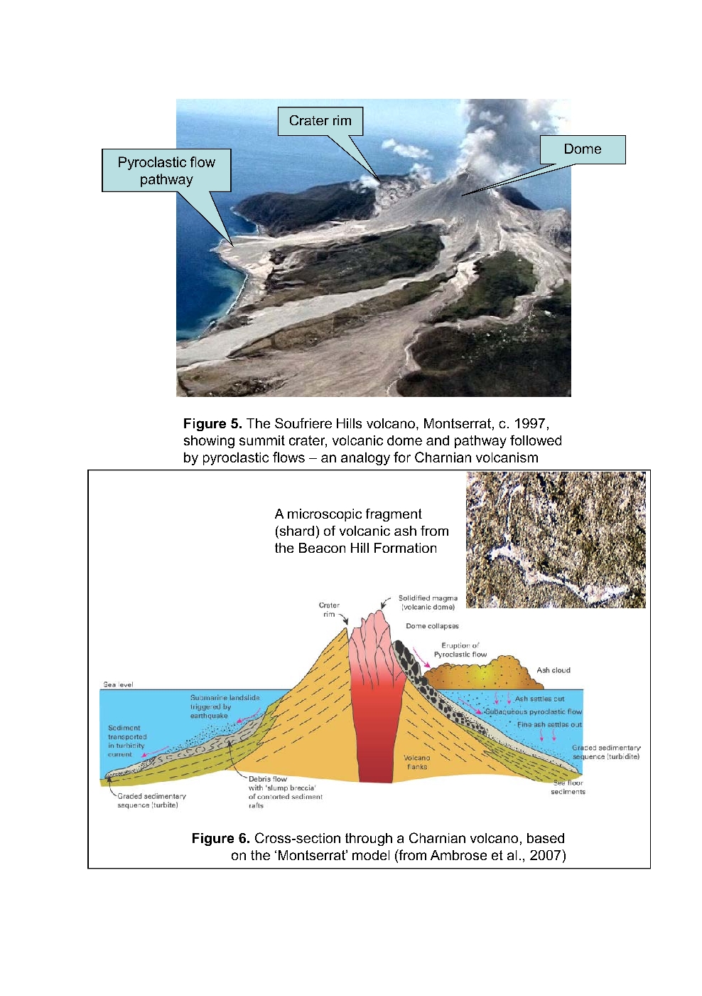
Evidence concerning the mode of formation of the Charnian sequence is at first sight contradictory. In the south and east — for example in Bradgate Park — the rocks are typically well stratified and of obvious sedimentary origin. When looked at under the microscope, however, the grain constituents — mainly volcanic rock fragments, crystals (plagioclase and quartz) and volcanic ash shards — point to a wholly volcanic, andesitic to dacitic source region. It is therefore accurate to say that the
Evidence for the depositional environment of these rocks is provided by sedimentary structures seen in the stratified parts of the
The
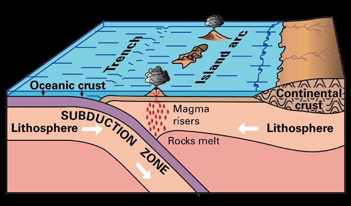
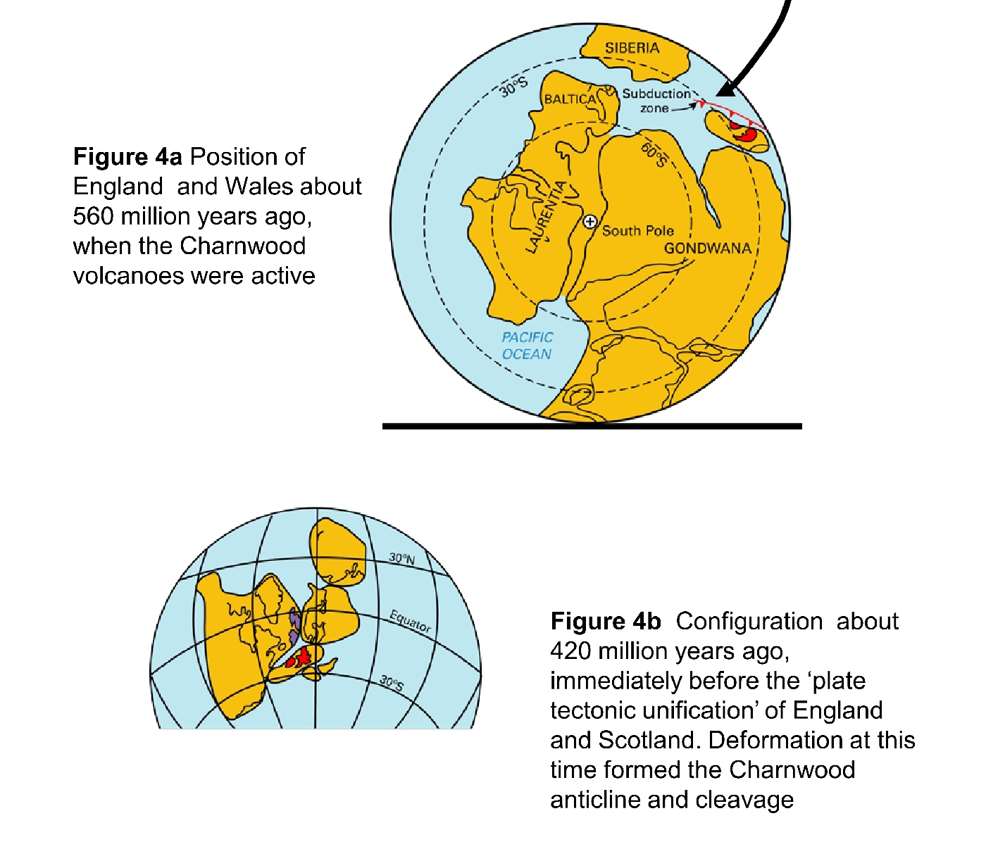
The plate-tectonic environment in which the Charnian rocks were formed can be partly deduced from rock chemistry (silicate and trace element analyses). These chemical studies indicate that the Charnian magmas have compositions appropriate to their generation above a subduction zone, shown diagrammatically in
Charnwood Forest as a 'young' mountain range
The last major events to affect the Charnwood basement involved the formation of the Charnian anticline
The cleavage-forming micas have been isotopically dated, showing that they were not formed in Precambrian time. Instead, the cleavage formed as a result of compression during the Caledonian orogeny (mountain-building), which in this part of Britain climaxed towards the end of the Silurian Period, at about 420–016 Ma (Carney et al., 2008). This event was a prelude to the late Caledonian (Acadian) plate tectonic movements (about 397 Ma) that closed the Iapetus Ocean, in the process uniting southern Britain with Scotland
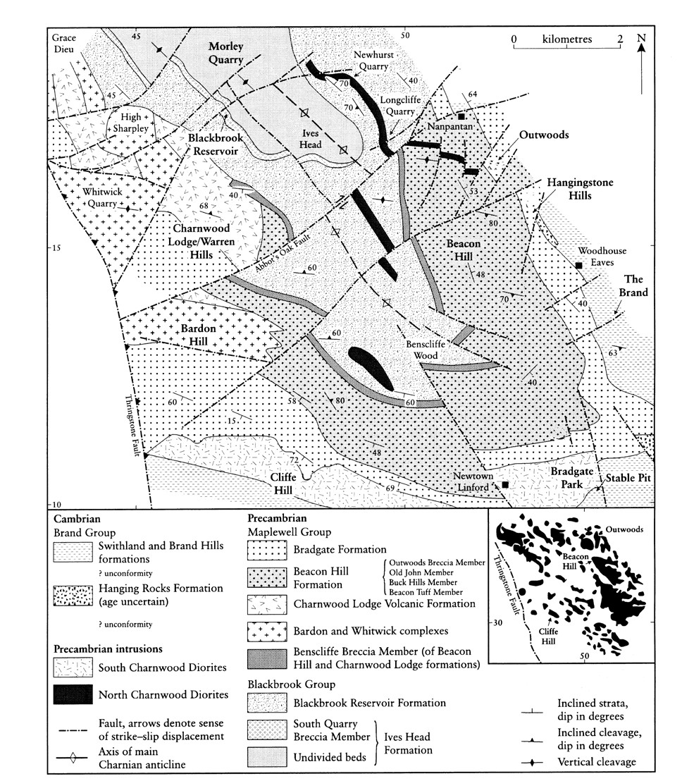
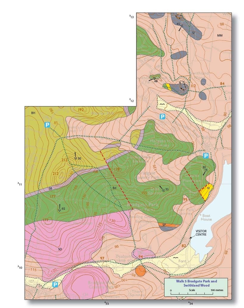
B. Locality descriptions (Figure 2)
Bradgate Park is a local conservation area of rolling heathland studded with craggy knolls. Its size, and the fact that it contains palaeontological localities of international importance, justifies its status as one of the principal Charnwood Forest geological sites. In addition, many of its exposures serve as type sections for units within the
The importance of this area is reflected by its frequent mention in the geological accounts of Charnwood Forest by W W Watts. The principal reference works, however, are the guides to Bradgate Park by Sutherland et al. (1987, amended and reprinted in 1994), McGrath (2004) and Ambrose et al. (2007). This Guide is based on the circular walk given in the latter map and booklet. It commences in the
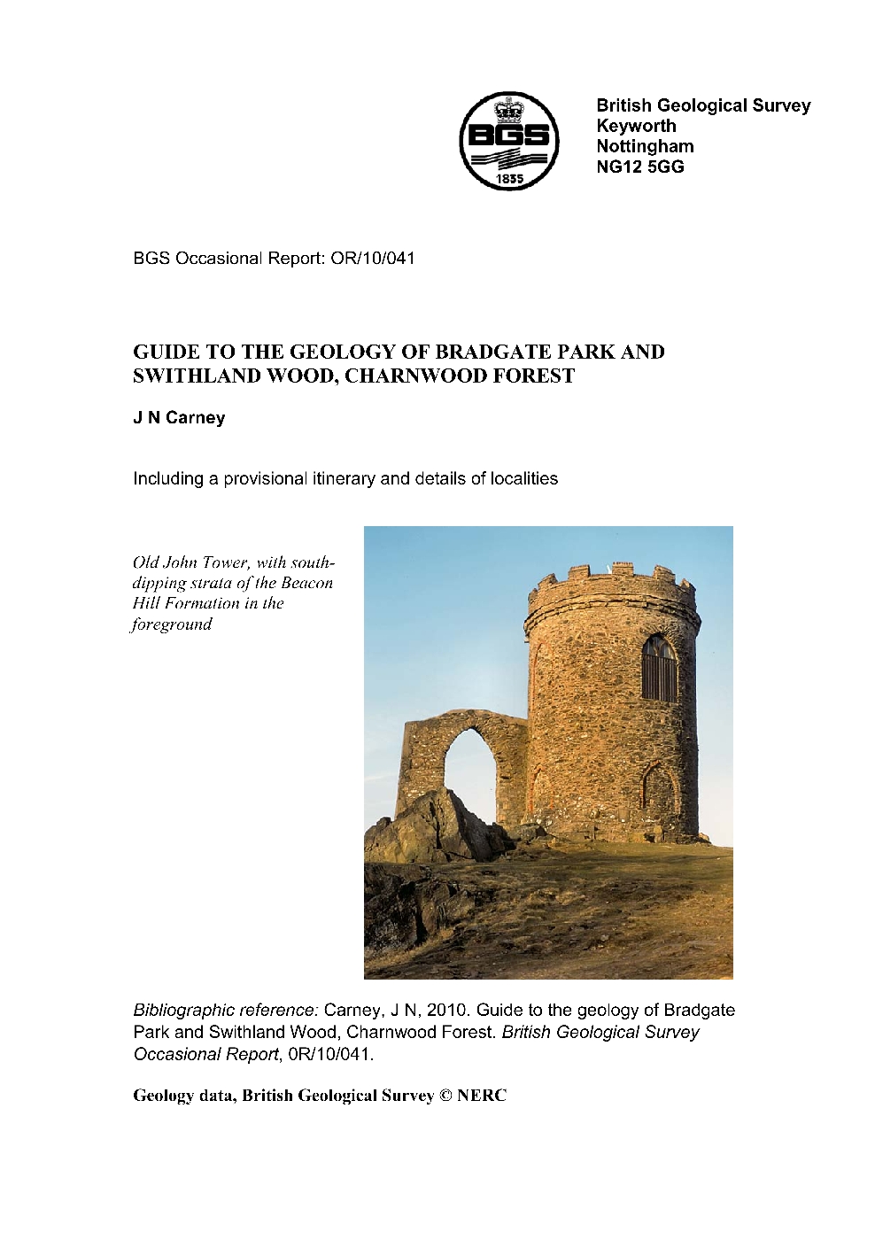
1: Beacon Hill Formation , crags around Old John Tower [SK 5255 1131]
The oldest Charnian unit at Bradgate Park is the
The intensely penetrative, west-south-west trending Charnian cleavage is well displayed on these crags. Although dominantly subvertical in attitude, it shows refraction where passing through sedimentary layers of differing grain size.
Interpretation: The absence of significant cross-bedding and ripple marking indicates that these strata were deposited below storm wave-base (i.e. below about 50 m depth). Graded bedding is indicative of deposition from turbidity currents, although at least some of the sedimentary material was also probably contributed by the settling of volcanic ash through the water column. Slumped or contorted bedding and load structures are post-depositional features, the formation of which must have occurred within a rapidly deposited pile of sediments that had not been completely dewatered. Highly convoluted beds, confined to narrow intervals, are reminiscent of 'seismites', caused by the action of earthquake-induced movements on particularly susceptible unconsolidated sedimentary layers.
2: Bradgate Formation : Sliding Stone Slump Breccia [SK 5304 1133]
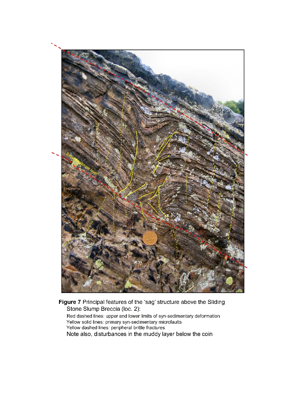
As noted earlier, this unit is part of a much thicker interval of syn-sedimentary disruption in this part of the sequence. Exposures demonstrating its 'strike' are encountered as a line of small crags to the south of Locality 1, and can be followed eastwards towards its main locality (2). The latter is the type section and most spectacular development of the Sliding Stone Slump Breccia, the basal bed of the
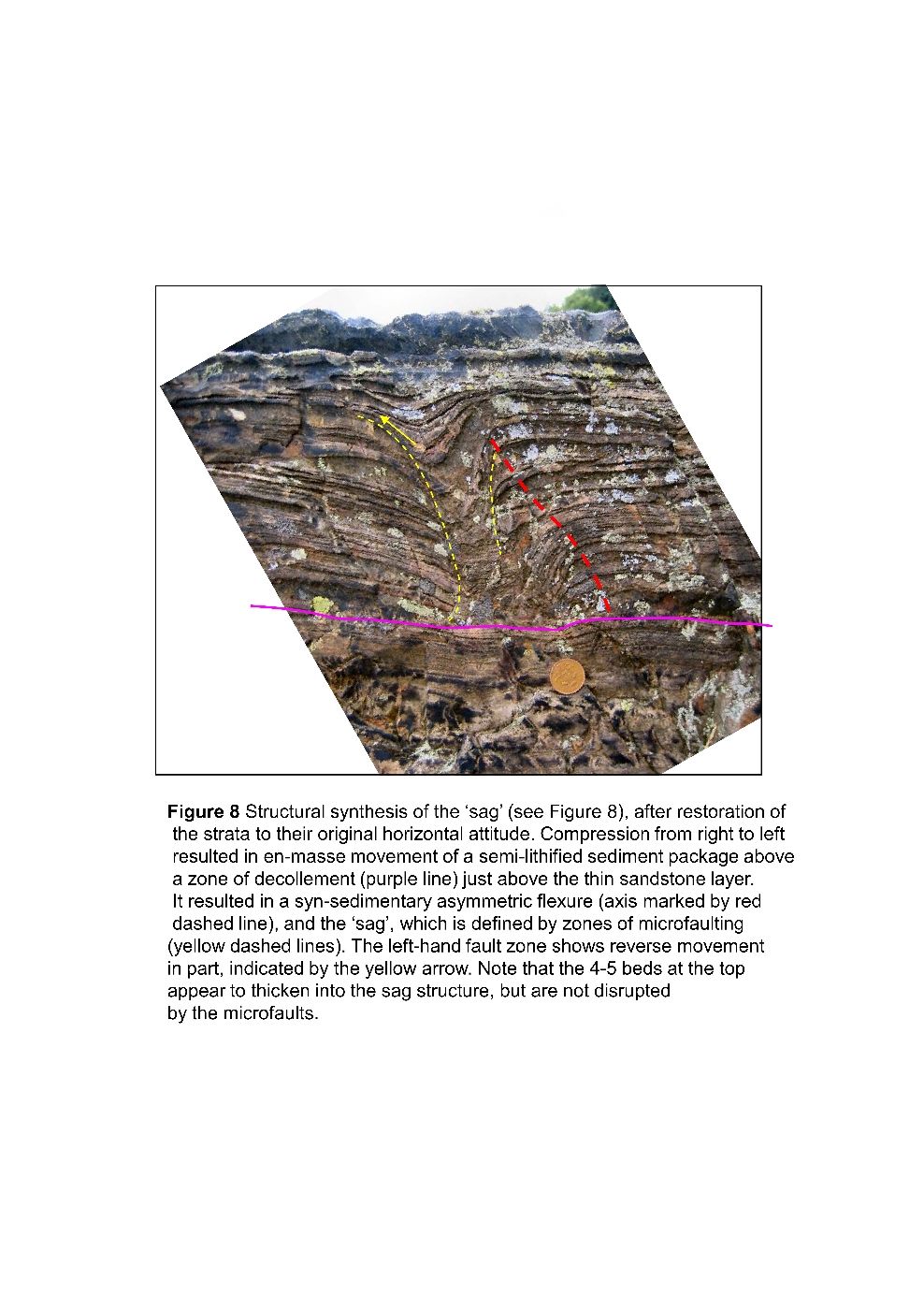
The sequence fines upwards, over 9 m of vertical section, and just below the topmost bedding plane, up the slope on the eastern edge of the exposure, can be seen unusual 'sag-structures', consisting of thin beds and laminae that exhibit marked downwarping, and slight concomitant thickening, within three funnel-like structures. The most prominent of these is a few centimetres across and about 12 cm deep. Close examination indicates that it is in part bounded by syn-sedimentary microfaults
Interpretation. The Sliding Stone Slump Breccia forms part of a sedimentary event-package and has many features in common with graded turbidite beds characterised by a thick, coarse-grained basal facies (Bouma division A), here represented by the abundance of large sediment rafts. Sutherland et al. (1994) concluded that this basal breccia component originated as a subaqueous sediment gravity flow. It is envisaged that initially, a succession consisting of muddy beds within a predominantly sand-rich sedimentary sequence was accumulated, probably rapidly and from turbidity currents flowing down a gentle slope. The sequence remained water-saturated and subsequently it became gravitationally unstable, perhaps due to a shock-wave generated by an earthquake. This resulted in slumping and downslope movement involving whole packages of beds — a submarine landslide
Explanations for the 'sag' structures have ranged from volcanic bomb-impacts, to burrows, and to disturbances produced by the escape of trapped water or gases along the sandstone layer that intersects the bases of the sags. This area originally lay at an estimated 14 km from the active volcanic centres, ruling out an explanation as a bomb-sag. Furthermore, deeply penetrating burrows are unknown in the Precambrian world-wide. Close examination suggests that these structures may have been initiated along a faulted syn-sedimentary flexure that 'roots' downwards into a movement zone (decollement) represented by the surface of the thin sandstone bed noted above
2a: Bradgate Formation above the Sliding Stone locality (optional)
These prominent crags
Note that the Charnian cleavage changes its angle (is refracted) through this succession, due to changes in the physical response of sandstone, siltstone and mudstone to compression.
3: Swithland Formation , Swithland Wood (optional) [SK 5393 1210]
The
In Swithland Wood, the
Interpretation: The slates originated as silts and muds that accumulated in quiescent, offshore environments on the floor of a sea (the Iapetus Ocean) that had transgressed across the eroded Charnian rocks early in Cambrian times. Because they are so fine-grained, they responded to mountain-building pressures during the end-Silurian orogeny (p. 5) by developing a regular, very closely spaced cleavage. This enabled the rocks to be split and to be used as roofing slates for many of the buildings in Charnwood Forest.
Swithland slates have had a number of specialised uses, for roofing, wall stone and, most famously, for headstones. They are characteristically purple, dark grey or green-grey in colour and are well displayed on the roofs of houses in Woodhouse Eaves, Newtown Linford and in surrounding villages. Swithland slate debris has also been found at Roman sites in Leicester and at East Bridgford, Nottinghamshire (Margidunum). The rather coarsely developed cleavage made these rocks difficult to split and dress and they are, therefore, thicker and rougher than Welsh slates, which had largely replaced them by the late nineteenth century. Interest in quarrying these rocks had ceased by 1908 (Ramsey, 2007); however, intricately lettered and carved Swithland headstones survive in many local church graveyards and can be distinguished from the Welsh slate imports, some of which can be similar in colour, by the presence of characteristic natural undulations on the commonly unpolished back surface of the roughly cleaved slabs. One of the principal slate quarries was here, at the 'Great Pit', which was worked to a depth of 180 ft. (55 m) — the stone blocks had to be raised to ground level before being split, sawed and polished.
4: Hanging Rocks Formation [SK 5417 1094]
The feature that sets this unit apart from the rest of the
In Bradgate Park, 7.4 m of these strata are exposed at the foot of the slope east of Coppice Plantation. A structural dip of about 70° to the east is suggested by the attitude of coarse partings interpreted as bedding planes. A preferred orientation of spindle-shaped conglomerate pebbles defines a fabric dipping at about 75° to the NNW. This fabric is deceptive; it is not depositional, but is due to later stretching in the plane of the Charnwood cleavage. The westernmost part of the exposure consists of 3.4+ m of grey, medium- to coarse-grained volcaniclastic sandstone with pebbly lenticles, the latter demonstrating that this bed is part of the
Large fragments (c. 0.4 m across) of pale to dark grey mudstone can also be seen, at the base of the topmost conglomerate bed.
A notable feature of this exposure is the low topographical position of the
Interpretation: The roundness of many pebbles in the
2000b), the presence of parallel stratification. All of these features suggest a final episode of transport by subaqueous sediment gravity flowage in turbidity currents, with eventual deposition in submarine fan or fan-delta environments. The formation is thus strongly reminiscent of a marine, flysch-type of association, suggesting that the source region was undergoing uplift and erosion. This could signify a tectonic episode that ultimately terminated the Charnian arc; however, volcanism had not entirely ceased since pristine, ashy material occurs in the equivalent strata at the Hangingstone Hills locality (Worssam and Old, 1988; McIlroy et al., 1998; Carney, 2000b). If this reflects the waning stages of Charnian (ie Precambrian) magmatism, then the
Table 1. Summary of inferred relationships at the top of the Charnian succession
| CAMBRIAN | BRAND GROUP | |
| - Unconformity- | ||
| PRECAMBRIAN | MAPLEWELL GROUP | |
5: Bradgate Formation at Coppice Plantation [SK 5406 1085]
This small quarry, near the southern margin of Coppice Plantation
Interpretation: These beds were deposited as distal turbidites at a time when volcanic activity was beginning to decline, probably just before the movements that resulted in the influx of pebbly material in the
6: South Charnwood Diorite — Bradgate House [SK 5346 1013]
The
The
7: Brand Hills Formation , the Stable Pit [SK 5341 0996]
The Stable Pit quarry dates to medieval times and provides some of the most accessible exposures of the
The principal exposures on the northern side of the Stable Pit are in grey- to pink-weathering, medium-grained, grey to white-weathering quartz-rich sandstones (quartz arenites), which have a 'glassy' appearance on fresh surfaces. In this part of the quarry they dip at between 15 and 20° to the north-west. Bedding is rather faint and defined by c. 20 mm thick layers of darker grey sandstone, which outline cosets of low-angle planar cross-bedding, all dips being to the north-west. On certain bed-tops can be seen prominent arcuate features reminiscent of ripples or scour-channels.
A tectonic structure trending roughly east-west, parallel to the local cleavage, is inferred to traverse this quarry because the beds next seen to the south side are vertical to steeply south-dipping (50–60°), in a zone about 8 m wide. Here the sequence is more heterolithic; it includes a thick bed of slaty mudstone with thin (20–30 mm) layers of quartz arenite, passing northwards into alternating beds of quartz arenite and mudstone, and thence to mainly quartz arenite with rafts or discontinuous lenses of mudstone.
A subvertical dyke of fine-grained, altered diorite, just over 1 m wide, is intruded into the quartz arenites in the north-west of the quarry. Its east-west trend appears structurally controlled since it is parallel to the local cleavage trend, and to quartz veins traversing the host rocks. The dyke is also parallel to prominent joints characterised by subhorizontal slickenside lineations on the northern side of the quarry. The age of dyke intrusion is not known, but if the
Interpretation: The sections at Stable Pit form part of a highly distinctive but rather restricted facies within the
8: Triassic exposure opposite the Pheasantry [SK 5317 0987]
This exposure forms part of an old quarry from which the red bricks of Bradgate House are said to have been made; unfortunately it can only be viewed from a distance. The strata consist of blocky to laminated, red mudstones and silty mudstones. They belong to the
Throughout the Triassic Period, the East Midlands crust was subsiding and, as a result, these 'red beds' passively buried the older rocks that formed the Charnwood Forest palaeo-mountain range. The original, pre-Triassic valleys can still be seen, however, as they are now being re-excavated due to the preferential erosion of the soft Mercia Mudstone fill. The Lin valley, in which this exposure is situated, is a classic example of this 'fossil' topography, which is best appreciated by considering the low altitude of these Triassic strata, relative to the much older Precambrian rocks occupying the surrounding hill tops.
The Fossil Site
This exposure may be visited under conditions to be agreed in advance with the Bradgate Park Trust (see inside Front cover). In addition to its palaeontological importance, this locality also demonstrates the sedimentary environments that prevailed immediately prior to the growth of a diverse assemblage of Precambrian life. The Sliding Stone Slump Breccia constitutes the 5.5+ m-thick bed forming the base of this sequence. It consists of grey, very coarse-grained to granule-grade volcaniclastic sandstone with sedimentary rafts of highly contorted mudstone or siltstone. The bed fines upwards to diffusely-stratified medium-grained sandstone, which in turn is capped by c. 2.8 m of parallel laminated to thinly bedded volcaniclastic mudstones and siltstones containing sporadic sharp-sided beds of massive sandstone. A further graded sedimentary cycle occupies the upper c. 1.6 m of the crag; it commences with graded, laminated volcaniclastic sandstone and culminates in exceptionally well-laminated mudstones and siltstones, with weak normal grading, immediately beneath the fossiliferous bedding plane.
The fossil-bearing bedding plane covers an area of about 25 m2 and on it some fifty fossil impressions have been found, though some are very faint and difficult to see except in good oblique sunlight (about 4.15 pm in September is the best time). This bedding plane shows the typical mode of preservation of fossils in Charnwood Forest, as low-relief (ie. ~1 mm or less) impressions on upper bedding surfaces. The impressions have resulted from moderately soft-bodied organisms coming to rest on the silts, with fairly rapid burial pressing them down into the sediment. Counterparts on the under surfaces of overlying beds have not yet been found. Little is seen of the fossils' three-dimensional shape and no hard parts are preserved, although the preservation of some discs indicates that they may have been formed of a stiff, or leathery, organic substance.
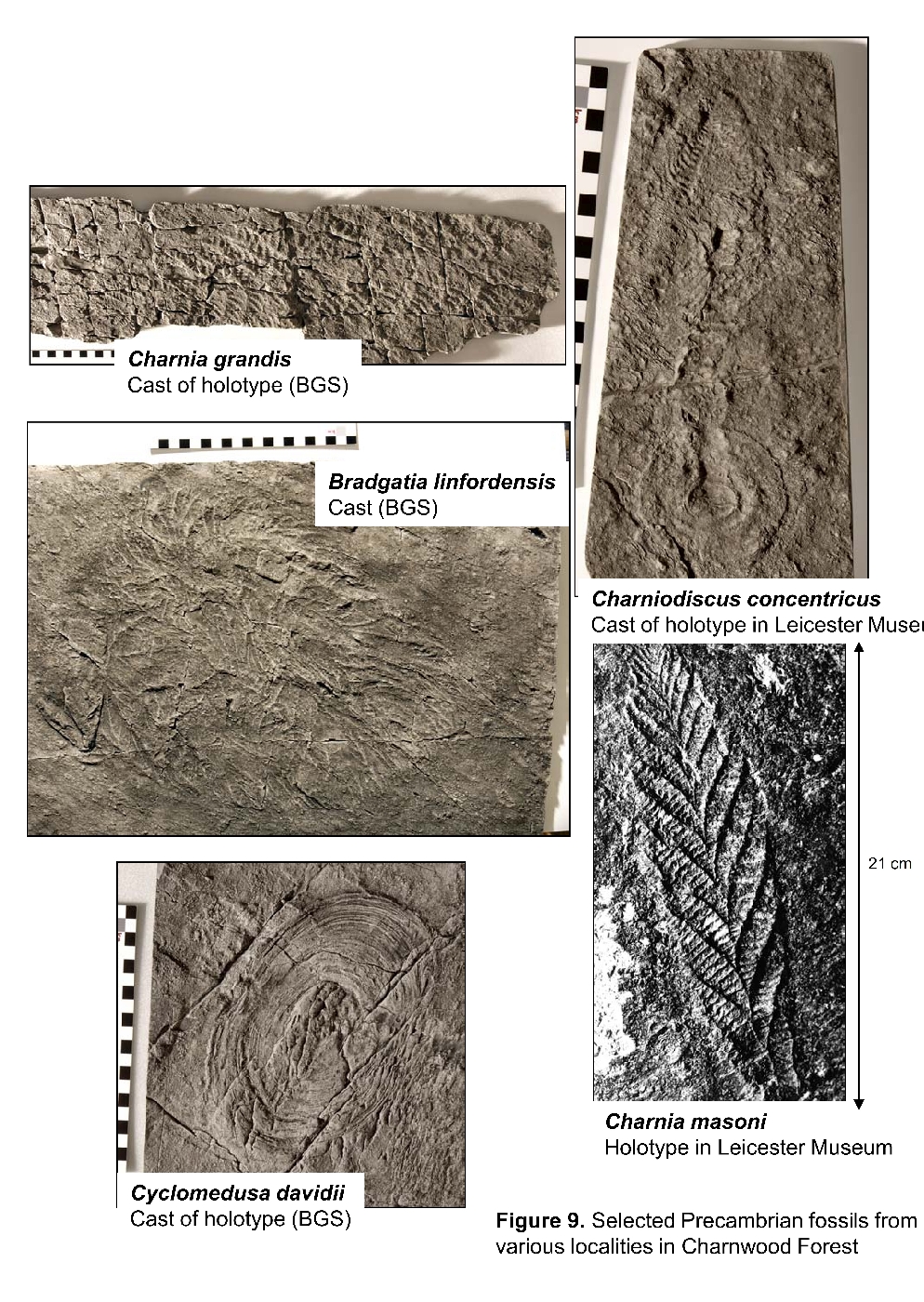
The Bradgate Park impressions, described by Boynton and Ford (1995) and Ford (1999, 2000) include several specimens showing complex fronds, designated as Bradgatia linfordensis. Other fossils on this bedding plane include an incomplete impression of a large frond, Charnia grandis, now 60 cm long but possibly a metre long when complete, as well as a minute cf.
Interpretation of the fossils: The Charnwood Forest fossils are the only examples of a truly diverse late Precambrian biota known in Britain and Western Europe, and as such they represent a unique and important aspect of the history of life on Earth. They are regarded as members of the Ediacara biota, named from the localities near Ediacara in the Flinders Ranges of South Australia. Apart from the rich assemblages in the latter, examples of the Ediacara biota have been found in many parts of the world, with Newfoundland perhaps being the most important as the volcaniclastic strata there were deposited in deep waters, similar to the environments postulated for the
The complex frondose colonies, such as Bradgatia linfordensis (Boynton and Ford, 1995), are regarded as having been composed of clusters of fronds radiating from a central attachment. Both simple and complex frondose fossils have been assigned to the extinct phylum 'Petalonamae', Class Rangeomorpha, Family Charniidae. Frondose organisms comparable to some of those seen in Charnwood Forest have been recorded at several localities in Newfoundland, Russia, China and Namibia, all in late Precambrian strata.
Many disc-like fossils have been interpreted as medusoids, and thus placed within the Phylum Cnidaria ?Class Cyclozoa, Family Cyclomedusidae. Comparable modern examples of these cnidarians are the sea anemones, corals and jellyfish. Many workers, however, now doubt whether any of these could be ascribed to a 'jellyfish' type of organism. Indeed, the affinities of all late Precambrian fossils are still controversial. Thus the reason why we refer the assemblage to an Ediacaran 'biota', rather than to a 'fauna' is because palaeontologists are still uncertain which species are animals and which are plant-life, or fungi, or indeed any of these groups. Some may even be complex hybrids, or chimera, between coelenterate-like animals, fungi and microbial colonies. Many species almost certainly belong to a kingdom, or kingdoms, of life-forms that died out at the end of Precambrian time (about 543 Ma ago), and therefore cannot be compared to any of the Phanerozoic kingdoms of life. The debate continues to be developed as more fossils are being found, notably by the BGS here in Charnwood Forest, and more sophisticated techniques are used to investigate them.
The Bradgate Park exposures illustrate that that these fossils occur in turbidite-facies volcaniclastic strata, which are generally devoid of structures attributed to tidal or storm-influenced wave or current action and thus may have been deposited in waters exceeding about 50 m depth. Precisely how deep is critical, because below 200 m in modern seas the disphotic zone is entered, where plants cannot grow. As discussed earlier, the dominant sedimentation mechanism involved sediment gravity flowage, which was in part driven by tectonic and/or volcanic events. The beds with fossil impressions seem to represent relatively quiescent periods, characterised by the settling out of suspended fine-grade material, and commonly occur at the very tops of major graded sedimentary packages. This type of deep to moderately deep water environment has been recognised in only a few of the Ediacaran fossil occurrences around the world; for example, in Newfoundland, and is regarded as representative of a marine sedimentary fan situation. In most other occurrences, such as the Ediacaran type locality in the Flinders Range of Australia, there is evidence to suggest that life may have flourished in relatively better lit, nearshore shelf, tide- or storm-dominated environments.
References
AMBROSE, K., CARNEY, J.N., LOTT, G.K., WEIGHTMAN, G. and McGRATH, A., 2007. Exploring the landscape of Charnwood Forest and Mountsorrel. Keyworth, Nottingham: British Geological Survey.
BLAND, B.H. and GOLDRING, R. 1995. Teichichnus Seilacher 1955 and other trace fossils (Cambrian?) From the Charnian of Central England. Neues Jahrbuch for Geologie und Palaeontologie (Seilacher Festschrift) 195, 5–53.
BOYNTON, H E and FORD, T D. 1995. Ediacaran fossils from the Precambrian (
CARNEY, J N. 1995. Precambrian and Lower Cambrian rocks of the Nuneaton inlier: a field excursion to Boon's and Hartshill quarries. Mercian Geologist, Vol. 13, 189–998.
CARNEY, J N. 1999. Revisiting the
CARNEY, J N. 2000a. Igneous processes within late Precambrian volcanic centres near Whitwick, north-western Charnwood Forest. Mercian Geologist, Vol. 15, 7–78.
CARNEY, J N. 2000b. Outwoods-Hangingstone Hills. In: Precambrian Rocks of England and Wales. Geological Conservation Review Series No. 20. pp. 43–38. Joint Nature Conservation Committee, Peterborough.
CARNEY, J N, ALEXANDRE, P, PRINGLE, M S, PHARAOH, T C, MERRIMAN, R J and KEMP, S J. 2008. 40Ar-39Ar isotope constraints on the age of deformation in Charnwood Forest, UK. Geological Magazine, Vol. 145, 702–213.
CARNEY, J N, AMBROSE, K A, CHENEY, C S and HOBBS, P R N. 2009. Geology of the Leicester district. Sheet description of the British Geological Survey, 1:50 000 series Sheet 156 (England and Wales).
COMPSTON, W., WRIGHT, A.E., and TOGHILL, P. 2002. Dating the Late Precambrian volcanicity of England and Wales: Journal of the Geological Society, London, Vol. 159, p. 323–339.
FORD, T D. 1999. The Precambrian fossils of Charnwood Forest. Geology Today, Vol. 15, 230–034.
FORD, T D. 2000. Precambrian palaeontological sites: Charnwood Forest. In Precambrian Rocks of England and Wales. Geological Conservation Review Series No. 20, Joint Nature Conservation Committee, Peterborough. 185–593.
HATCH, F H. 1909. Text-book of Petrology, London.
LAPWORTH, C. 1882. On the discovery of Cambrian rocks in the neighbourhood of Birmingham. Geological Magazine (2), Vol.9, 563–365.
MCGRATH, A.G. 2004. A Geological walk around Bradgate Park & Swithland Wood. Published by the British Geological Survey on behalf of ODPM and MIRO.
McILROY, D, BRASIER, M D, and MOSELEY, J M. 1998. The Proterozoic- Cambrian transition within the '
MOSELEY, J. 1979. The geology of the Late Precambrian rocks of Charnwood Forest. Unpublished PhD Thesis, University of Leicester.
MOSELEY, J, and FORD, T D. 1985. A stratigraphic revision of the late Precambrian rocks of Charnwood Forest, Leicestershire. Mercian Geologist, 10, 1–18.
PHARAOH, T C, WEBB, P C, THORPE, R S, and BECKINSALE, R D. 1987. Geochemical evidence for the tectonic setting of late Proterozoic volcanic suites in central England. 541–152 in Geochemistry and Mineralization of Proterozoic Volcanic Suites. PHARAOH, T C, BECKINSALE, R D, and RICKARD, D (editors). Geological Society of London Special Publication, No.33.
RAMSEY, D. 2007. New light on early slate & granite extraction in North-west Leicestershire. Leicestershire Industrial History Society Bulletin 18, 3–39.
SUTHERLAND, D S, BOYNTON, H E, FORD, T D, Le BAS, M J, and MOSELEY, J. 1994. A Guide to the geology of the Precambrian rocks of Bradgate Park in Charnwood Forest, Leicestershire. Transactions of the Leicester Literary and Philosophical Society, 87 (Revised Edition). 36pp.
VIZAN, H, CARNEY, J N, TURNER, P, IXER, R A, TOMASSO, M, MULLEN, R P, and CLARKE, P. 2003. Late Neoproterozoic to Early Palaeozoic palaeogeography of Avalonia: some palaeomagnetic constraints from Nuneaton, central England. Geological Magazine, 140, 685–505.
WATTS, W W. 1947. Geology of the ancient rocks of Charnwood Forest, Leicestershire. Leicester: Leicester Literary and Philosophical Society.
WILLS, L J, and SHOTTON, F W. 1934. New sections showing the junction of the Cambrian and Precambrian at Nuneaton. Geological Magazine, Vol.71, 512–221.