Show interactive timeline
An excursion guide to areas of very low grade metamorphism in the Lake District and the Rhinns of Galloway
R.J. Merriman, N.J. Fortey and B. Roberts
British Geological Survey Technical Report Mineralogy & Petrology Series Report No. WG/91/8
Date:18 March 1991
Bibliographic reference R.J. Merriman, N.J. Fortey & B. Roberts An excursion guide to areas of very low grade metamorphism in the Lake District and the Rhinns of Galloway British Geological Survey Technical Report WG/91/8
NERC 1991 British Geological Survey Keyworth, Nottingham NG12 5GG, UK
Geographical index: UK; Lake District, Rhinns of Galloway
Subject index: Low grade metamorphism; white mica crystallinity; Lower Palaeozoic strata
Introduction
As a contributor to BGS Core Programme surveying in Lower Palaeozoic slate terranes in the British Isles, the Mineralogy and Petrology Group has carried out extensive surveys of very low grade metamorphism (VLGM) in metasedimentary rocks. An important, integral part of this work has been the continued collaboration of Dr Brin Roberts of the University of London and his colleagues Patrick Daly and Steve Hirons.
During 1989 the International Geological Correlation Programme established Project 294 on "Very Low Grade Metamorphism". The first conference of this project, entitled "Phyllosilicates as indicators of very low grade metamorphism and diagenesis" was held in July 1990 at the University of Manchester, and was convened by RJ Merriman (BGS), Dr G Droop (University of Manchester) and NJ Fortey (BGS) The conference drew together diverse workers from different continents, thus enabling wide reaching exchange of expertise and the resolution of discrepencies in practises employed to investigate VLGM.
In addition, the joint BGS-London University group welcomed the opportunity to lead a post-conference excursion to review patterns of VLGM in the English Lake District and Southern Scotland. As with the conference itself, the support given by the Survey's staff was amply rewarded in terms of "state-of-the-art" expertise gained, contacts established and overall enhancement to the prestige of the Survey.
Preparation of an excursion guide provided the chance to set out and review results obtained on the field areas to be visited, and to discuss their interpretation. The guide is reproduced here as a Mineralogy and Petrology report in order to keep a permanent record of its contents and to make them more widely available.
Contents
Itinerary
Introduction
Summary of the geology and metamorphism of the English Lake District
Summary of the geology and metamorphism of the Southern Uplands
Geological details of Stops 1–18
Reference List
Accommodation: Hotel addresses, telephone numbers and dates
List of the members of the excursion party
Figures
Itinerary
Friday 6 July
Depart Manchester at 16.30: drive to The Horseshoe Hotel, Ambleside, Lake District.
Saturday 7 July
Stop 1. Borwick Fold Hill; Bannisdale Slates, Silurian, Ludlow
Stop 2. Allen Heads Quarry; Conniston Grits, Silurian, Lower Ludlow.
Stop 3. Applethwaite Slate Quarry; Brathay Flags, Silurian, Lower Wenlock
Stop 4. Lunch at Brotherswater.
Stop 5. Troutbeck; Skiddaw Slates; Ordovician, Arenig.
Stop 6. Mungrisedale and ; Skiddaw Slates, Ordovician, Arenig.
Stop 7. River Caldew; hornfelsed Skiddaw Slates, Skiddaw Granite aureole.
Return to Ambleside.
Sunday 8 July
Stop 8. Chaple Stile Quarry;
Stop 9. Kirkstone Gallery; coffee.
Drive to Scotland.
Stop 10. Lunch at Southwaite Services M6.
Stop 11. Isle of Whithorn;
Drive to The Downshire Arms Hotel, Portpatrick, Rhins of Galloway.
Monday 9 July
Stop 12. Corsewall Point;
Stop 13. Portpatrick;
Stop 14. Port Logan;
Stop 15. Lunch at Logan Botanic Garden.
Stop 16. Grennan Slate Quarry;
Stop 17. Clanyard Bay;
Stop 18. Mull of Galloway;
Return to Portpatrick
Tuesday 10 July
Party returns to Manchester, arriving at approximately 15.00 hours. Arrangements will be made for one minibus to leave the hotel very early (∼06.30) to reach Manchester by midday.
Introduction
It is widely accepted that in the early Lower Palaeozoic the various terranes of the British Isles lay close to a triple collisional junction. Here, two major continental terranes, Laurentia and Baltica, collided with a third microcontinental terrane comprising southern Britain and nearby Europe, which is referred to as Eastern Avalonia (Soper et al. 1987; Soper and Woodcock, in press). The Iapetus ocean, which separated Laurentia and Eastern Avalonia, became a zone of closure. The site of closure is now taken to be represented by the Iapetus suture, a notional suture line trending NE–SW and lying within the Solway Basin. In Newfoundland, evidence for closure of Iapetus in the middle to late Ordovician is reported (Williams & Hatcher 1983; Pickering et al. 1988), but in Britain it is now generally accepted that closure occurred in the Silurian (Barnes et al. 1989; Soper & Woodcock in press). As a consequence of closure, two contrasting Lower Palaeozoic terranes are now juxtaposed. To the northwest of the Iapetus suture, the Scottish Southern Uplands terrane comprises a succession of predominantly thickly bedded volcaniclastic and terrigenous turbidites with subordinate graptolitic shales, ranging in age from middle Ordovician to late Silurian. Southeast of the Iapetus suture, the Lower Palaeozoic of the English Lake District consists of a succession of early Ordovician to late Silurian mudrocks, calc-alkaline volcanics and turbidites. Regional low grade metamorphism on both sides of the suture ranges from late diagenetic to epizonal. The purpose of this excursion is to examine the relative influences of lithology, deformation and burial conditions on low grade metamorphism in two contrasting geodynamic environments generated by closure of Iapetus.
Summary of the geology and metamorphism of the English Lake District
Introduction
The English Lake District has had a long history of quarrying and underground mining. Quarrying operations have worked slate, limestone, roadstone and granite as well as coal and iron ore. Slates for roofing and building were (and are) produced from grey Wenlockian mudstones at Kirkby-in-Furness and from green Caradocian andesitic tuffs at Broughton Moor, Chapel Stile, Kirkstone, Honister and other sites. The famous Cumbrian green slates are seen in buildings and walls throughout the area, and often give excellent displays of sedimentary structures on cleavage planes.
Geology
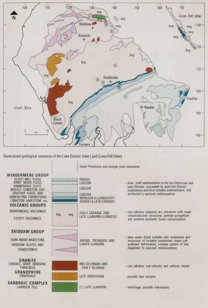
The Lake District is a large inlier of early Ordovician (Tremadocian) to late Silurian (Pridoli) sedimentary and volcanic rocks emerging from beneath the Carboniferous and Permian strata that cover most of Northern England. These rocks are also seen in the smaller, fault bounded Cross Fell inlier NE of the main inlier
Following tradition, the sedimentary-volcanic succession of the Lake District is split into three main divisions
The ca. 5 km thick sediments of the
Interpretation of the geological history of the Eycott and Borrowdale Volcanic Groups is currently under revision. It is generally agreed that the characteristics of the outcrop of the latter group indicates subaerial calc-alkaline volcanism. This structurally complex sequence of lavas, pyroclastics, volcaniclastic sediments and high level intrusions, ca. 4 km thick, is marked by volcanotectonic faulting during prolonged subsidence (Branney, 1988). Overstep of the base of the BVG indicates that emergence and erosion of the underlying
Much of the volcanic sequence was preserved beneath the unconformable base of the mudstones and impure limestones of the lower part of the Windermere Group. Deposition of these rocks persisted until middle Wenlock time, when northerly derived turbidites mark the onset of subsidence and rapid sedimentation which continued until the Lower Devonian (Acadian) folding and cleavage development (Soper et al. 1987). The group is ca. 7 to 8 km thick. Windermere Group mudrocks lack both paragonite and chlorite-mica stacks, in common with mudrocks of the Southern Uplands. However, the thick upper part of the group is dominated by sandstones and siltstones with few true mudrocks.
In considering the thickness of the succession it is important to note that the unconformable bases of the volcanic rocks and Windermere Group mark periods of erosion. Therefore, depths of burial were not accumulative throughout the succession as three separate periods of subsidence and sedimentation took place.
The age of the main Caledonian WSW–ENE subvertical slaty cleavage is well constrained in the Windermere Group. Here it cleaves late Ludlovian sediments but is cut by the middle Devonian Shap Granite (N J Soper, field excursion, 1989). Strong cleavage of the same trend can be traced northeastwards into the
Fitton & Hughes (1970) interpreted the Eycott and Borrowdale Volcanics as products of southeasterly directed subduction of the Iapetus oceanic lithosphere which originally floored the basin which separated the Lake District from Laurentian terranes further north. This view was supported by faunal evidence of wide separation of the two terranes until the middle Silurian (Fortey et al. 1989), and evidence for derivation of Lake District sediments from the Southern Uplands only from the middle Silurian onward (Furness, 1965). Soper & Hutton (1984) reconstructed the pattern of plate movements in the Caledonides, placing the Lake District on the NW side of the East Avalonian microcontinent which collided with the Laurentian continent. Middle Silurian (Wenlock) collision was followed by a period of sinistral transcurrent movements on WSW–ENE trending faults and eventually the Lower Devonian (Acadian) orogeny. This last event caused the Caledonian folding and cleavage seen throughout much of the paratectonic Caledonides, and involved major and widespread crustal shortening. In the Lake District, sinistral transpression during the shortening can be deduced from the arcuate trend of fold-cleavage transections in the Windermere Group (Soper et al. 1987). Interpretation of the Ordovician-Silurian tectonics of the Southern Uplands as a SE-directed rising thrust stack (Stone et al. 1987) has led to the view that the late Silurian sedimentation and subsequent deformation of the Lake District involved southwards migration of a foreland basin across the line of closure of the Iapetus ocean into the Eastern Avalonian terrane (Barnes et al. 1989).
Metamorphism in the Lake District
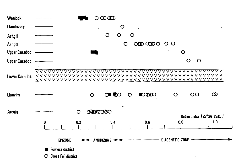
The first direct determination of regional metamorphic grade in the Lake District was probably by Bergstrom (1980) for the lower Windermere Group using conodont maturation indices. Values of 5 (300–400°C) and, locally, 4 (190–300°C) suggest epizonal or upper anchizonal metamorphism. Later, Thomas (1986) studied illite crystallinity by measuring the Weber Hb .rel index for 2–6 micron fractions from sedimentary rocks and the mineralogy of basic volcanic rocks, concluding that the area had undergone anchizonal or prehnite-pumpellyite facies burial metamorphism probably at more than one stage related to its history of successive burials. Oliver et al. (1984) and Allen et al. (1987) also record prehnite-actinolite facies metamorphism in parts of the
Oliver (1988) presented graptolite reflectance measurements mostly for the Windermere Group. These results show a down-sequence pattern of increasing reflectance from diagenetic values (122.3) in the Bannisdale Slates (Ludlow) to upper prehnite-pumpellyite facies values (6.4–8.5) for the Brathay Flags and underlying Stockdale Shales (Wenlock and Llandovery respectively). Oliver (1988) comments that the values for the Bannisdale Slates are at variance with anchizonal illite crystallinity values recorded by Thomas (1986), probably because the illite data is influenced by the component of detrital mica in the rocks.
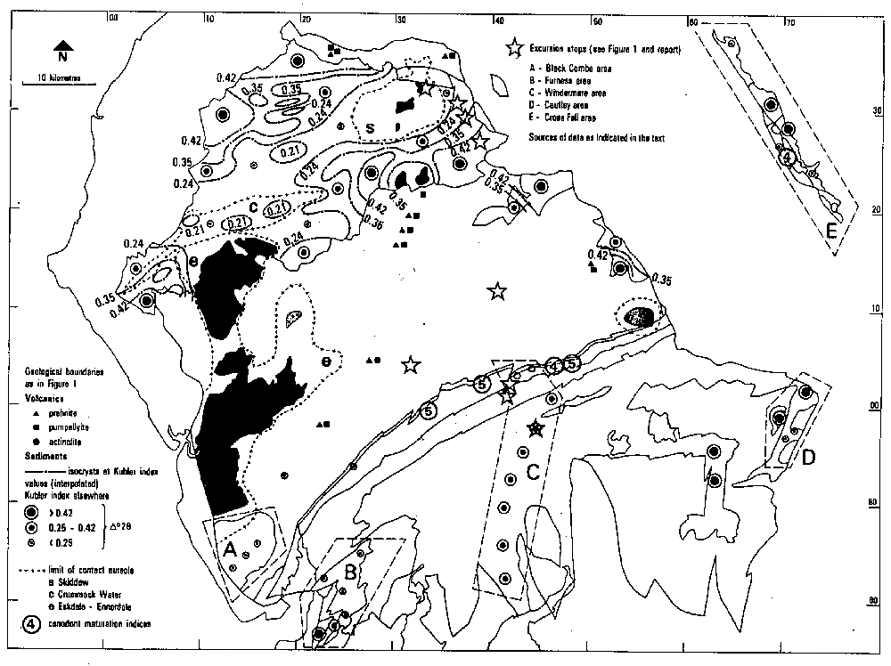
A Kubler index survey of the
Recent results (unpublished) have involved the Furness, Windermere, Cautley and Cross Fell areas (see Figure 2). At Cross Fell, the Kubler index varies from formation to formation with 'sharp changes and apparent inversion of metamorphic grade
The results suggest that crystallinity varies with lithology, underlining the view that a survey of white mica crystallinity should concentrate on samples of terrigenous mudrock, avoiding sandstones or volcanogenic mudstones. Clearly, in the Lake District this restricts the extent of possible sampling, and it becomes difficult to know which of the
In contrast, very restricted variation was observed in Kubler indices (0.26–0.32Δ° 2θ) from siltstones in the Bannisdale Slate (Ludlow) sampled along a ca. 20 km cross strike section in the Windermere area
Alternatively, in view of the strong cleavage present throughout the Bannisdale Slate cross strike section it is difficult a priori to accept a grade no higher than diagenetic for these rocks. New mica growth during metamorphism associated with the folding and cleavage formation should be dominant in the <2 micron fractions so that the limited variation in the Kubler indices along the section implies an even degree of metamorphism across the southern Lake District. The difference in crystallinity between the Bannisdale Slate and the Brathay Flags could thus result from a lithological control such as differences in the kinetics of new mica growth during metamorphism rather than different degrees of metamorphism.
The conclusions of this discussion are that:
- An upper anchizonal to epizonal grade of metamorphism, or its metabasic volcanic equivalent, has affected much of the area, and that this was established during the Lower Devonian regional metamorphism.
- Some of the variation observed in Kubler indices reflects lithological controls which either affect the process and kinetics of new mica growth or the susceptibility of the rocks to retrograde alteration, possibly during uplift or deep weathering.
The first conclusion is less simple than it seems. The
Besides very low grade regional metamorphism, the Lake District contains some good examples of contact metamorphism around the high level granite intrusions. The contact aureole around the cupola of the Skiddaw Granite is a classic example in which concentric zones of increasing intensity of metamorphism are present. An outer zone of bleached slate and spotted hornfels gives way via successive andalusite, biotite and cordierite isograds to an inner zone of cordierite-biotite-hornfels. Garnet occurs only rarely. Sillimanite has not been recorded, suggesting a relatively high structural level. At the Grainsgill locality (Excursion stop 7) hornfelsic alteration of
Another example of contact alteration is the Crummock Water Aureole, a linear, 7 x 1 km zone of bleaching, induration, chloritic spotting and tourmalinisation developed over a concealed dyke-like granitic intrusion emplaced along the trend of the Crummock Water Fault (Cooper et al. 1987). Pelites in this aureole take on a lepidoblastic bedding fabric, although chlorite-mica stacks and locally detrital grains are still recognisable in thin section. Paragonite contents are variable, locally matching that of muscovite. The micas are the 2M polytype. Kubler indices reach 0.19–0.21 Δ° 2θ where paragonile is absent, consistent with a model of metasomatic recrystallisation indicated by the presence of tourmalinisation and other geochemical changes. Chlorite is abundant, whereas biotite is a very minor constituent.
Summary of Southern Uplands geology and metamorphism
Geology
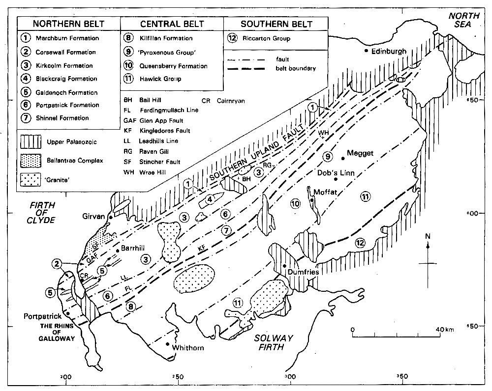
Following the pioneering work of Peach and Horne (1899), the Southern Uplands lying south of the Southern Upland Fault, has been traditionally divided into Northern, Central and Southern Belts
Although the succession is dominated by turbidites, lithological variations are present from belt to belt. Thus the Northern Belt succession consists mainly of volcaniclastic and terrigenous turbidite sandstones, graptolitic shales and occassional basic lavas and cherts. The Central Belt consists mainly of terrigenous and volcaniclastic turbidite sandstones and subordinate graptolitic shales. Finally, the Southern Belt comprises mostly terrigenous turbidite sandstones and graptolitic shales.
Beds presently are steeply dipping to vertical and within each fault-bounded tract mostly young to the NW. However the successions comprising each tract, overall, become younger to the SE
The terrane has been interpreted as an accretionary prism by. McKerrow et al. (1977) and by Leggett et al. (1979). Each fault-bounded tract is taken to represent a succession of fore-arc sediments sliced off the oceanic plate as it was subducted to the NW beneath a continental margin. Accretion developed under the toe of the SE-aggrading prism as a series of slices bounded by continent-dipping thrust faults. As the prism developed, earlier accreted slices were steepened by backward rotation and acquired a pattern of very low grade metamorphism related to burial (Oliver and Leggett 1980).
In the past decade, BGS surveys in the Southern Uplands and research in the Irish extension of this terrane have produced alternatives to the accretionary prism model. Both Murphy and Hutton (1986) and Stone et al. (1987) pointed out that the arrangement of faults previously interpreted as characteristic of subduction and accretion constitutes an imbricate thrust stack, and that the tectono-stratigraphic pattern can equally well be generated by thin-skinned, SE directed thrusting. Moreover, palaeocurrent evidence from volcaniclastic turbidites indicates that fresh andesitic detritus was derived from the south, implying the existence of a volcanic arc situated on the oceanic side of the fore-arc region. An alternative model thus envisages a back-arc setting for the Southern Uplands, which simultaneously received quartzose turbidites from a mature continental landmass to the north and turbidites, rich in fresh volcaniclastic detritus, from an ensialic volcanic arc to south (Styles et al. 1989). Following oblique collision, initiated in the Llandovery, under-thrusting of the Laurentian marginal basin by Eastern Avalonia generated a SE-propagating thrust stack. An associated middle Wenlock, southward migrating foreland basin is envisaged by Barnes et al. (1989) as developing ahead of the rising thrust stack on the leading edge of Eastern Avalonia. There is claimed to be firm evidence of a sedimentary link in the Late Wenlock between the Southern Uplands and the Lake District (Soper and Woodcock, in press).
Metamorphism in the Southern Uplands
Studies of metabasic volcanic rocks and volcaniclastic turbidites show that prehnite-pumpellyite facies metamorphism is widely developed in the Northern and Central Belts of the Southern Uplands (Oliver and Leggett, 1980). Illite crystallinity, illite b parameters and graptolite reflectance data derived from two loW-density sampling traverses across the Southern Belt indicate consistent anchizonal grades in the northeast but late diagenetic grades in the southwest of the Southern Belt (Kemp et at., 1985).
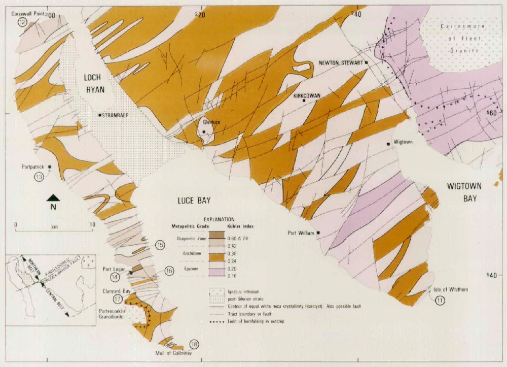
White mica crystallinity studies of low grade pelitic rocks were initiated in 1986 as part of the BGS Southern Uplands Regional Geological Survey. These studies, which use a sampling density of 1–2 pelite samples per square kilometer, have closely followed geological mapping and revision of areas in the southwest part of the Northern and Central belts. Initially, computer-generated metamorphic maps were derived from data plotted on 1:50,000 scale. The maps showed rapid changes in grade across the traces of some, but not all, of the proven strike-parallel faults and, in general, isocrysts were oblique to the strike.of the bedding. Consequently the maps were re-drawn by hand, treating proven faults (both strike-and dip-parallel) as potential metamorphic discontinuities. A simplified and reduced version of unpublished metamorphic maps is shown in
Interpretation of the isocryst pattern
Within fault-bounded tracts, the oblique intersection of the isocryst surfaces with bedding planes, the absence of systematic variation in grade with younging direction of strata, and the fact that lowest grade rocks include the oldest tract (
One working hypothesis, in terms of the subduction model, could evoke a modified burial metamorphism with essentially depth-controlled, approximately horizontal isocryst surfaces developing in a set of steeply inclined, strike fault-bounded packets of strata. Little or no post-metamorphic movement on the strike faults results in continuity of metamorphic grade across the faults; but subsequent movement (eg sinistral strike-slip) results in discontinuities. If this movement were coupled with a rotation of packets about axes approximately normal to the strike-parallel faults then the pattern observed could be generated. Late Palaeozoic NW–SE trending normal faults, eg the Loch Ryan Fault, up-throwing to the east, necessarily expose deeper, and therefore higher grade, metamorphic levels.
Mudstones in the Central Belt of late diagenetic grade merit further comment. In these tracts beds young to the SE rather than NW. McCurry and Anderson (1989) interpret such tracts as having been obducted rather than subducted whereas Stone et al. (1987) would interpret them, in terms of thin-skinned tectonics, as backthrust tracts. In each model, the tracts would have been less deeply buried than adjacent tracts and hence are of lower metamorphic grade.
Highest grades are found within the
The primary pattern is overprinted by contact metamorphic effects associated with late Silurian and early Devonian granitoid intrusions. Concentric patterns of metamorphic grade are developed around the Cairnsmore of Fleet, Creetown and Portancorkrie intrusions, where biotite-cordierite hornfelses are found in the inner aureoles. Elsewhere smaller intrusions may generate epizonal or high-anchizonal concentric aureoles. Other concentric and ellipsoidal patterns of steep metamorphic gradient, ranging up to epizonal grade, may indicate concealed minor intrusions.
Lake District itinerary
This first part of the field excursion will examine metamorphosed sedimentary and volcanic rocks in the Lake District inlier. The first morning will be concerned with lithologies of the Windermere Group, and the following afternoon with the older
Saturday July 7th
Stop 1 — Bannisdale Slate at hilltop exposure near to Borwick Fold farm [SD 446 971]
The first three stops of the excursion are in successively older rocks of the Windermere Group. At Stop 1, a close-spaced, sub-vertical fracture cleavage is developed throughout thinly bedded pale grey siltstones and fine sandstones. The rocks belong to the ca. 3 km thick Bannisdale Slate (Middle Ludlow), distal turbidites deposited by rapid sedimentation during subsidence of the late Silurian foreland basin. Cleavage is approximately axial planar to open minor folding with a gentle easterly plunge, though a small clockwise transection relative to fold hinges can be demonstrated. The locality lies within the belt of ENE to E trending periclinal folds and strong cleavage which extends across the southern Lake District, related to Lower Devonian sinistral transpression. A sample of grey siltstone from here gave a Kubler index of 0.29 Δ° 2θ, close to values measured from 22 other samples of cleaved Bannisdale Slate collected on a 20 km cross strike traverse across this belt. This uniformity of crystallinity is in contrast with.the variability found in the
The hilltop site gives a panoramic view in which the hill country of the Windermere Group is in contrast with the more rugged uplands of the
Stop 2 — Coniston Grits at Allen Heads quarry. [NY 415 011]
The beds exposed in this old roadstone quarry are steeply inclined turbidites belonging to the ca. 2 km thick Coniston Grits (Lower Ludlow) which underlie the Bannisdale Slates. Bouma sequences, some > 2 m thick at this site, are dominated by massive greywacke sandstone beds, but also possess silty and muddy tops in which slaty cleavage is developed. The beds strike 055° and dip 70° SE; cleavage strikes 050° and is sub-vertical. Sedimentary structures here include grading and ripple-drift lamination. The sandstones are muscovitic, highly feldspathic and locally rich in rock fragments including rhyolitic lavas and flow foliated lavas of more basic character. The Windermere Group is thought to have extended northwards over the older rocks of the sequence, and Furness (1965) considered that a lithological correlation exists between the Coniston Grits and the
Stop 3 — Brathay Flags at Applethwaite quarry. [NY 423 034]
This quarry lies within the Brathay Flags (Lower to Middle Wenlock), a ca. 300 m thick sequence of uniformly grey silty mudstones, much of which display a fine, regular carbonaceous banding. The beds were deposited as distal turbidites, probably in a deep water. Some 50 m, of silty mudstones, striking 070° and dipping about 40° SE, is exposed in this quarry , which lies on the SE limb of the ENE trending Nan Bield anticline, a major Caledonian structure. A sub-vertical penetrative cleavage is present throughout the quarry, trending approximatley 070°, and was the basis for the rough slate worked at this site. Kubler indices of 0.20 and 0.22 Δ° 2θ were measured on two samples whose <2μm mineralogy comprises 2μm muscovite, chlorite and quartz. Several K-bentonitic tuff bands, up to 4 cm thick, occur at 0.5–1.0 m spacings in part of the exposed succession. Most have a 'sandy' character due to the presence of feldspar and pyrite crystals set in an illitic groundmass, but at least one is distinct in consisting of remnants of illitic material invaded by calcite veining. Kubler indices for two of the tuffs are 0.24 and 0.31Δ° 2θ , only slightly lower grade than the enclosing mudrocks.
The Party are warned that the quarry faces are unstable, and are asked to avoid the high rear faces of the quarry, and to hammer spoil material rather than the dangerous rocks faces.
Stop 4 — Road traverse across the Borrowdale Volcanics, and lunch stop at the Brotherswater Inn. [NY 403 119]
The route crosses the outcrop of the
Stop 5 — Skiddaw Slate at Troutbeck stream section. [NY 385 270]
Stops 5 to 7 show aspects of metamorphism within the
At Stop 5 a shallow gorge has exposed conspicuously soft, tightly folded dark grey shaley mudstones. Numerous isoclinal minor folds with sub-horizontal hinges lack an axial planar cleavage. Thin sandstone beds may pass around closures without rupture, but numerous detached sandstone lenses lie within the mudstones more generally. Siliceous nodules occur locally in the mudstones. Thin sections show the presence of chlorite-mica stacks, unusually rich in the mica component, and the presence of a weak crenulation cleavage. Accompanying sandstones possess a calcite cement marked by the presence of microscopic spherules of probable biogenic origin. Varying bedding orientations of strike:145°/dip:45°NE and strike: 064°/dip: 56°NW were measured at different points here. Lower Arenig fossils have been recorded (S Molyneux, personal communication), but interpretation of the rocks as mudflow deposits similar to the Late Arenig
Stop 6 — Skiddaw Slates at Mungrisedale.
If time permits, two stops will be made in this area.
- Loweswater Flags in old quarry at Mungrisedale village
[NY 363 305] . - Kirkstile Formation at Bowscale End
[NY 360 314] .
In the first, steeply dipping beds of hard, dark grey siltstone and fine sandstone of the Lower Arenig Loweswater
The second part of Stop 6 is in exposures on the open fellside at Bowscale End in folded dark grey pelites and fine interbedded sandstones, attributed to the Kirkstile Formation (Arenig). Two sets of penetrative cleavage are indicated by fine crenulation fabrics, seen on lustrous mudstone bedding surfaces, trending 260° and 340°. A Kubler index of 0.32 Δ° 2θ was measured here in a <2μm fraction consisting of interlayered muscovite-paragonite, chlorite and minor quartz. Cleavages in the upper anchizonal to epizonal rocks of the Skiddaw Slate are generally poorly developed in sandstone beds, and are rarely truly penetrative, in contrast with that in the Windermere Group. The reasons for this contrast could involve some degree of pre-cleavage burial induration at a high geothermal gradient, in a back or intra-arc setting, prior to Caledonian tectonism.
Stop 7 - Hornfelsed Skiddaw Slate at Grainsgill. [NY 327 326]
Exposures at the confluence of Grainsgill with the River Caldew are in contact metamorphosed rocks of the
On the return to Ambleside the route passes through St Johns in the Vale, where prominent S-inclined benches in the hillside west of the valley are created by the contrast between basic lavas and softer interbedded tuffs of the lower part of the Borrowdale Volcanics.
Sunday July 8th
Stop 8 - Green slate quarry at Chapel Stile, Langdale. [NY 324 049]
This locality can be considered to represent a number of sites at which high quality roofing slate has been worked in the Lake District. The quarry, operated by the Burlington Slate Company, is one of three still in operation. It is sited in massive, pale green water-lain andesitic tuffs of the Tilberthwaite Tuff Formation, part of the upper
In addition, a prominent set of joints lies approximately perpendicular to the cleavage and at an acute angle to bedding. Within the volcanic rocks as a whole, cleavage is best developed in the massive tuffs, and poorly developed in compact lavas.
Stop 9 — Coffee stop at Kirkstone Gallery prior to the drive to the Southern Uplands. [NY 343 034]
Before embarking on the 2–3 hour drive into southern Scotland, we shall take the opportunity to visit the excellent cafeteria and the gallery of the Kirkstone Slate Company where a variety of mementos can be obtained. After leaving here the route will be N across the Borrowdale Volcanics via Thirlmere and across the
Stop 10 — Lunch stop at Southwaite Services, M6 Motorway.
Southern Uplands itinerary
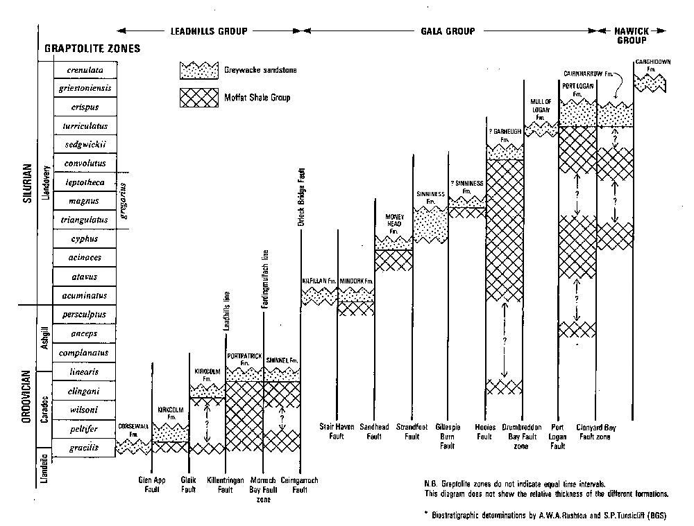
On Monday July 9, the excursion will make a traverse (Stops 12–18) through the imbricate sequence of the Northern and Central Belts, from the oldest to youngest tracts, examining the effects of lithology and deformation on the grade of metamorphism. For logistical reason the first stop in the Southern Uplands (Stop 11) will be made on Sunday July 8 at the Isle of Whithorn. Here the party will be introduced to the lithologies and the style of deformation to be examined the following day.
In collaboration with Professor D R Peacor, Department of Geological Sciences, University of Michigan, electron microscope studies have been made of three samples representing typical late diagenetic, anchizonal and epizonal pelites encountered on the Rhins of Galloway. Some results of this, as yet, unpublished work are included in the notes for appropriate stops, and a selection of SEM and TEM lattice fringe electron micrographs will be available for discussion on the evenings of 8 and 9 July.
Stop 11 — Isle of Whithorn. [NX 481 359]
Greywacke sandstones and shales of the
XRD analysis of <2μm separations from the cleaved mudstones show that 2M1 white mica and chlorite are abundant, with minor albite, ankerite and quartz. Kubler indices range from 0.28–0.36Δ° 2θ, suggesting mid-to high-anchizonal grades.
Monday July 9th
Stop 12 — Corsewall Point. [NW 982 728]
Greywacke sandstones, conglomerates and mudstones of the
Approximately 15 m east of the jetty, alongside a stone wall, a slot is eroded along a small tear fault. Here, dark grey-green occasionally reddened, laminated silty mudstones are interbedded with steeply dipping sandstones and conglomerates. The mudstones may show a poorly developed spaced cleavage dipping less steeply than bedding. Scanning electron microscope (SEM) study of the silty mudstone, using back-scattered electron images (BSEI), show grains of quartz, albite, K-feldspar, biotite flakes (<0.5 mm), magnetite and rare chromite, in a phyllosilicate matrix which lacks an obvious fabric. X-ray diffraction (XRD) analysis of the <2μm separations shows that the matrix is mainly composed of 'corrensitic' chlorite characterized by a broad relatively intense 14Å peak, and 10Å illite, which gives a Kubler index of 0.6Δ° 2θ. Similar, late diagenetic grade Kubler indices were obtained from other mudstone samples from the
Stop 13 — Portpatrick.
Greywacke sandstones and mudstones of the
On the north side of the harbour the
Detailed SEM and TEM studies were made of a shale from the
Stop 14 — Port Logan. [NX 094 404] .
Greywacke sandstones and mudstones of the
Stop 15 — Lunch at Logan Botanic Garden [NX 097 429]
The garden is famous for its exotic plants, ferns and Australian gums).
Stop 16 — Grennan Slate Quarry [NX 127 394]
Slates and sandstones of the
Stop 17 — Clanyard Bay [NX 098 377]
Dark grey and black shales of the
XRD analysis shows that the shales typically contain 2M white mica and chlorite, with minor albite and quartz, in <2 gm fractions; Kubler indices of 0.26–0.27Δ° 2θ suggests that the grade is high anchizone. The metabentonites consist of mixed-layer illite/smectite, with up to 5% smectite, and traces of chlorite; the Kubler index of 0.55Δ° 2θ indicates a much lower 'grade' than the enclosing shales. A thin section of the metabentonite shows scattered chips (<0.3 mm) of altered lava, feldspar, apatite and rare zircon in the phyllosilicate matrix.
Stop 18 — Mull of Galloway [NX 157 304] .
Greywacke sandstones and slates of the
In thin section the greywacke sandstone clasts are predominantly of quartz (including quartzite, quartz schist, and rare granophyre, all < 2 mm), with microcline, muscovite, chloritized biotite, a few maffic and felsic lava clasts, and accessory tourmaline and zircon. The phyllosilicate matrix is extensively replaced by a calcite cement. BSEI of a slate sample show an anastomosing cleavage enclosing grains of quartz, albite and detrital phyllosilicates, including chlorite/mica stacks. Oriented TiO pseudomorphs appear to represent original heavy mineral-rich laminae. XRD analysis of <2 μm fractions indicate that 2μm mica (phengite) and chlorite are the dominant phyllosilicates, with minor albite, quartz and rutile. Kubler indices of 0.22–0.28Δ° 2θ indicate high anchizone-epizone grades suggesting that the rocks may have been carbonate-poor at the time of metamorphism. TEM lattice fringe images show intergrown chlorite and mottled phengite crystallites ranging from 15 to over 300 layers in thickness. Chlorite generally contains fewer crystal defects than phengite.
Reference List
Allen, P.M., Cooper, D.C. and Fortey, N.J. 1986. Composite lava flows in the English Lake District. Journal of the Geological Society of London, 144, 945–960.
Anderson, T.B. and Oliver, G.J.H. 1986. The Orlock Bridge Fault: A major late Caledonian sinistral fault in the Southern Uplands terrane, British Isles. Transactions of the Royal Society of Edinburgh: Earth Sciences, 77, 203–222.
Barnes, R.P., Lintern B.C. and Stone, P. 1989. Timing and regional implications of deformation in the Southern Uplands of Scotland. Journal of the Geological Society of London, 146, 905–908.
Bergstrom, S.M. 1980. Conodonts as palaeotemperature tools in Ordovician rocks of the Caledonides and adjacent areas in Scandinavia and the British Isles. Geologtska Foreningens i Stockholm Forhandlingar, 102, 377–392.
Branney, M.J. 1988. The subaerial setting of the Ordovician
Cooper, A.H. and Molyneux, S.G. 1990. The age and correlation of
Cooper, D.C., Lee, M.K., Fortey, N.J., Cooper, A.H., Rundle, C.C., Webb, B.C. and Allen, P.M. 1988. The Crummock Water aureole: a zone of metasomatism and source of ore metals in the English Lake District. Journal of the Geological Society of London, 145, 523–540.
Elders, C.F. 1987. The provenance of granite boulders in conglomerates of the Northern and Central Belts of the Southern Uplands of Scotland. Journal of the Geological Society of London, 144, 853–864.
Fitton, J.G. and Hughes, D.J. 1970. Volcanism and plate tectonics in the British Ordovician. Earth and Planetary Science Letters, 8, 223–228.
Fortey, N.J. 1990. Low grade metamorphism in the Lower Ordovician
Fortey, R.A., Owens, R.M. and Rushton, A.W.A. 1989. The palaeogeographic position of the Lake District in the early Ordovician. Geological Magazine, 126, 9–17.
Furness, R.R. 1965. The petrography and provenance of the Coniston Grits east of the Lune Valley, Westmorland. Geological Magazine, 102, 252–260.
Kemp, A.E.S., Oliver, G.J.H. and Baldwin, J.R. 1985. Low-grade metamorphism and accretion tectonics: Southern Uplands terrain, Scotland. Mineralogical Magazine, 49, 335–344.
Lawrence, D.J.D., Webb, B.C:, Young, B. and White, D.E. 1986. The geology of the late Ordovician and Silurian rocks (Windermere Group) in the area around Kentmere and Crook. Report of the British Geological Survey, Vol.18, No.5, 32p.
Lee, M.K. 1986. A new gravity survey of the Lake District and three-dimensional model of the granite batholith. Journal of the Geological Society of London, 143, 425–435.
Leggett, J.K., McKerrow, W.S. and Eales, N.H. 1979. The Southern Uplands of Scotland: A Lower Palaeozoic accretionary prism. Journal of the Geological Society of London, 136, 755–770.
McCurry, J.A. and Anderson, T.B. 1989. Landward vergence in the Lower Palaeozoic Southern Uplands-Longford-Down terrane, British Isles. Geology, 17, 630–633.
McKerrow, W.S., Legget, J.K. and Bales, M.H. 1977. Imbricate thrust model of the Southern Uplands of Scotland. Nature, 267, 237–239.
Millward, D., Moseley, F. and Soper, N.J. 1978. The Eycott and Borrowdale Volcanic Rocks. In Moseley, F. (ed) "The Geology of the Lake District", Yorkshire Geological Society Occasional Publication No.3, 99–120.
Murphy, F.C. and Hutton, D.H.W. 1986. Is the Southern Uplands of Scotland really an accretionary prism? Geology, 14, 354–357.
O'Brien, C., Plant, J.A., Simpson, P.R. and Tarney, J. 1985. The geochemistry, metasomatism and petrogenesis of the granites of the English Lake District. Journal of the Geological Society of London, Vol.142,-1139–1157.
Oliver, G.J.H. 1988. Arenig to Wenlock regional metamorphism in the Paratectonic Caledonides of the British Isles: a review. In Harris, A.L. and Fettes, D.J. (editors) The Caledonian-Appalachian Orogen, Geological Society Special Publication No.38, 347–363.
Oliver, G.J.H. and Leggett, J.K. 1980. Metamorphism in an accretionary prism: prehnite-pumpellyite facies metamorphism of the Southern Uplands of Scotland. Transactions of the Royal Society of Edinburgh, Earth Sciences, 71, 235–246.
Oliver, G.J.H., Smellie, J.L., Thomas, L.J., Casey, D.M., Kemp, A.E.S., Evans, L.J., Baldwin, J.R. and Hepworth, B.C. 1984. Early palaeozoic metamorphic history of the Midland Valley, the Southern Uplands-Longford Down massif and the Lake District, British Isles. Transactions of the Royal Society of Edinburgh, Earth Sciences, 75, 259–273.
Peach, B.N. and Horne, J. 1899. The Silurian Rocks of Britain. 1. Scotland. Memoir of the Geological Survey of the United Kingdom, 749p.
Pickering, K.T., Bassett, M.G. and Siveter, D.J. 1988. Late Ordovician-Early Silurian destruction of the Iapetus Ocean: Newfoundland, British Isles and Scandinavia - a discussion. Transactions of the Royal Society of Edinburgh: Earth Sciences, 79, 361–382.
Soper, N.J. and Roberts, D.E. 1971. Age of cleavage in the Skiddaw Slates in relation to the Skiddaw aureole. Geological Magazine, 108, 293–302.
Soper, N.J. and Hutton, D.W.H. 1984. Late Caledonian sinistral displacements in Britain: implications for a three plate collision model. Tectonics, 3, 781–794.
Soper, N.J. and Woodcock, N.H. (in press). Silurian collision and sediment dispersal patterns in southern Britain. Journal of the Geological Society of London.
Soper, N.J., Webb, B.C. and Woodcock, N.H. 1987. Late Caledonian (Acadian) transpression in north-west England: timing, geometry and geotectonic significance. Proceedings of the Yorkshire Geological Society, 46, 175–192.
Stone, P., Floyd, J.D., Barnes, R.P. and Lintern, B.C. 1987. A sequential back-arc and foreland basin thrust duplex model for the Southern Uplands of Scotland. Journal of the Geological Society of London, 144, 753–764.
Styles, M.T., Stone, P. and Floyd, J.D. 1989. Arc detritus in the Southern Uplands: mineralogical characterization of a 'missing' terrane. Journal of the Geological Society of London, 146, 397–400.
Thomas, L.J. 1986. Low grade metamorphism of the Lake District, England. Unpublished Ph.D. thesis, University of St Andrews.
Webb, B.C. and Cooper, A.H. 1988. Slump folds and gravity slide structures in a Lower Palaeozoic marginal basin sequence (the
Williams, H. and Hatcher, R.D. 1983. Appalachian suspect terranes. In Hatcher, R.D., Williams, H. and Zietz, I. (eds), Contributions to the tectonics and geophysics of mountain chains. Geological Society of America Memoir 158, 33–53.
Accommodation (dinner, bed and breakfast)
Nights of July 6th (Friday) and July 7th (Saturday):
The Horseshoe Hotel, Rothay Road, Ambleside, Cumbria, LA22 OEE [05394–32000]
Nights of July 8th (Sunday) and July 9th (Monday):
The Downshire Arms Hotel Portpatrick Wigtownshire Scotland [077681–300]
List of excursion party from 'Phyllosilicates' conference Manchester University, July 1990
Dr Fernando Alvarez
Daisy Barbosa Alves
Dr P Arkai
Dr R E Bevins
Dr Covadonga Brime
Dr D D Eberl
Dr N J Fortey
Professor R L Freed
Professor M Frey
Mrs Eveline Hayes
Dr W L Huang
Professor Warren D Huff
Professor J C Hunziker
Wei Teh Jiang
Professor H J Kisch
Professor B Kubler
Kenneth J T Livi
Dr F T Madsen
Mr R J Merriman
Dr Takashi Miki
Dr Ph Muchez
Dr Robin Offler
Dr T C Pharaoh
Raymond Beiersdorfer
Dr B Roberts
Dr D Robinson
Dr P Schiffman
Yen Hong Shau
Vaclav Ing Suchy
Dr Istva'n Viczia'n
Ms Chao Yang International Geological Correlation Programme