6 Geodiversity of Doncaster
6.1 Site of Special Scientific Importance (SSSI)
Four sites in Doncaster are listed as SSSIs
- Ashfield Brick Pit, Conisbrough (CadebyFormation)
- Bilham Quarry (CadebyFormation)
- Cadeby Quarry (CadebyFormation)
- New Edlington Brick-clay Pit (
Edlington Formation )
All four sites were cited under the Geological Conservation Review (GCR) process and the details are published in the Marine Permian of England GCR volume (Smith, 1995)
6.2 Regionally Important Geological/Geomorphological Sites (RIGS)
In 1997 the survey of geological sites in Doncaster by the South Yorkshire RIGS Group was essentially based on information gleaned from BGS Geological Memoirs and Maps, old Ordnance Survey maps and other relevant publications, largely provided by Doncaster Museum. The desktop research was undertaken by a small team of volunteers and enthusiastic amateurs, with the field work undertaken by a freelance geologist contracted on a fixed sum.
Based on criteria used to assess potential RIGS in Barnsley and Rotherham, RIGS in Doncaster were selected on the strength of:
- Representing a full cross-section of geological formations in the area
- Scientific value
- Education value
- Accessibility and aesthetic, recreation and amenity value
- Links with other biological, archaeological and architectural interests
Although several active hard rock and sand and gravel quarries were assessed as part of the 1997 field survey work, with some considered to merit RIGS status, the existing planning conditions and legislation, together with commercial interests of quarry operators deemed it necessary to omit certain sites from the RIGS selection process, even though on strict merit these would have been included in the final short list.
The increased protection now afforded to geological sites by PPS9 and the Local Development Framework and the realistic prospect of Geodiversity Action Plans, produced in conjunction with the private sector, has emphasised the need to devote professional expertise to the current project. With more time to assess each of the RIGS and related geological features, the 2007
Survey highlights the opportunity to reinforce geological links with current management plans, especially along the Don Gorge, where there is great potential to link to funding opportunities with English Heritage and Natural England, and along the Permian limestone escarpment.
The resurvey of sites was conducted during mid January to early March 2007. Site assessment data was collected using the UKRIG Site Assessment Form and entered into the UKRIGS GeoConservation Microsoft Access database. In practice, this database has proved very difficult to use, especially importing and exporting data and the translation into a user friendly report format. These database problems only came to light once the project was well underway, leaving no opportunity to introduce an alternative system.
It is therefore recommended that when undertaking future surveys of Sites of Scientific Interest within the borough, the compatibility of using this database alongside others used in Doncaster for Ecology, Archaeology and Architecture should be taken fully into account.
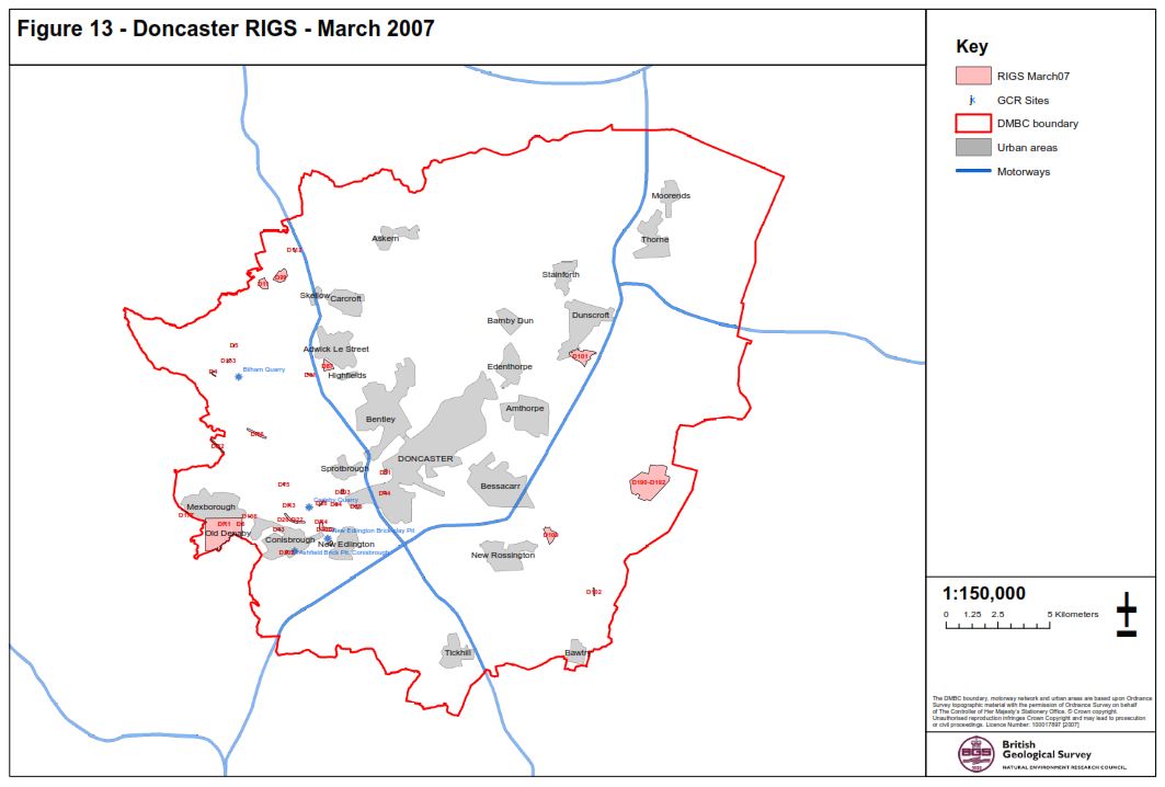
A summary of the 2007 survey is presented in Table 2 with sites plotted on
With respect to geological formations that are not well represented, difficulties still remain in that both the Permian marls and associated minerals, together with the soft Quaternary sediments, are extremely susceptible to natural weathering, quarrying operations and development and these are probably best recorded in addition to an archaeological or ecological survey that may be required as part of future works.
Table 2 Summary of Doncaster RIGS and potential RIGS site (D and DR in site number column respectively)
| Site No | Site Name | Site type | NGR | Stratigraphy | Current site condition | Geodiversity value | Score | Add, Remove or Keep |
| D6 | Denaby, Lane | Road cutting | Much of the section is overgrown and would be improved by selective clearance | Excellent geodiversity site (to be extended) for geology and a wide variety of landforms and fluvial geomorphology | 9 | Keep | ||
| D166 | Doncaster Road | Disused quarry | Partially overgrown | Moderately high, just because it is still the best exposure of |
7 | Keep | ||
| D177 | Wath Road Railway Cutting | Railway cutting | Completely infilled | No geodiversity value as site now completely infilled | 0 | |||
| DR2 | Harlington Railway Cutting | Railway cutting | Most of the eastern end is embankment. Western end more rocky but heavily vegetated | Limited. Very limited exposure of value to research and field mapping only | 5 | |||
| DR3 | Cadeby Waste Water Works | Disused quarry | Clean, clear rock faces. Shrubs and vegetation to lower rock face | Very good, on strength of rarity of |
8 | Add | ||
| DR1 | Denaby Woods - Mexborough Oxbow Lake | Geomorphological interest site | Areas of interest are in good condition but lie in and around areas that are rapidly developing | Very good. Faulting and folding, alluvial processes and geomorphology | 9 | Add | ||
| DR6 | Barnburgh Cliff | Exposure | Very good. Plenty of good exposure | A good site to show reef formation and associated beds. fissures and related deposits, an unconformity and geomorphology | 9 | Add | ||
| D11 | Hazel Lane Quarry | Active quarry | Plenty of exposed faces but quarry is being progressively landfilled | Good example of lithological variation in the |
5 | Keep | ||
| D4 | Watchley Crags | Disused quarry | The exposures furthest away from Watchley Lane are very good but the nearest are being increasingly littered | A very good site, for the rarity value, lithological variety and histoical, industrial archaeological interests | 8 | Keep | ||
| D15 | Mellon Park | Disused itiarry | The limestone is in excellent condition. The Yellow Sands would benefit considerably from vegetation clearence | A good range of geological processes can be demonstrated. Very high aesthetic/landscape value | 8 | Keep | ||
| D133 | Hooton Pagnell | Disused quarry | Vegetation and rubbish etc make access awkward but rock faces we largely free of vegetation and well exposed | A very good site, for the rarity value, lithological variety and historical/industrial archaeological interests | 8 | Keep | ||
| D13 | North Cliff Quarry | Disused quarry | Requires extensive clearance to improve access to best exposures. | A very good site with variable lithology, excellent landscape value and proximity to several very notable historic buildings | 9 | Keep | ||
| D5 | Hooton Pagnel Vilage Pound | Natural exposure | Very good, but some cutting back of vegetation around the reef exposure is required on a regular basis | Outstanding example of the creation of an estate village using local buiding materials with a particularly good reef | 9 | Keep | ||
| D20–022 | Cadeby Clif — Constitution Hill | Natural exposure | Several natural rock features well exposed. Old quarry requires clearance to facilitate access | A very good geodiversity site with a variety of lithological, geomorphological and historical interests | 9 | Keep | ||
| D112 | Parknook Quarry | Active quarry | Commercial use of site and rock waste, rubbish and vegetation etc limit ease of access | Moderate geodiversity value. Some interesting geological features but mainly valuable as a potential source of building stone | 7 | Keep | ||
| D28 | Pot Ridings Wood Railway Cutting | Railway cutting | Wetherby and Sprotbrough Members. |
Good exposures but access along the cutting was difficult at the time of the survey due to deep mud | Avery good insight into the importance of geology in determining the route of railway networks | 9 | Keep | |
| DR5 | Levitt Hagg Wood | Disused quarry | Overgrown but there are reasonable rock exposures to be seen | Possesses group value with other sites along the Don Gorge | 7 | Add | ||
| D94 | Warmsworth Quarry | Active quarry | Very good | Unusual occurrence of brecciated dolostone | 8 | Keep | ||
| D78 | Warmsworth Park | Disused quarry | Very good but needs to be cleaned regularly | A wide range of geological processes can be demonstrated. especially in conjunction with other nearby sites | 9 | Keep | ||
| DR4 | Nearcliff Wood Quarries | Disused quarry | Some rubbish. Fires and other debris associated with redundant quarries but acceptable for scientific visits | Extremely important in at least both a regional and national context for the use and exploitation of a natural resource | 10 | Add | ||
| D300 | Conisbrough Caves East | Caves | Some of cave entrances have been covered by landfill | Caves are of specialist speleological interest but associated breccias, rifts and slump structures are very interesting | 8 | Keep | ||
| D301 | Conisbrough Caves West | Caves | D/K | Entrances to both caves were not found and no geodiversity value could therefore be assigned | 0 | Remove | ||
| D302 | Conisbrough Caves South | Caves | Full of rubbish and damaged by fire. Well is maintained | Speleological research potential. Spring line associated with fault. Historic associations | 8 | Keep | ||
| D303 | Levitt Hagg Hole | Caves | Not found | The grid reference for the cave entrance appears to coincide with the restored Levitt Hagg Landfill Site and was not found | 0 | Remove | ||
| D61 | New Edington Brick Pit | Disused pit | Gypsum and marl not visible tree at survey. |
Main value relates to rare occurrence of gypsum in a landscape dominated by human activity. waste tips and industry | 5 | Keep | ||
| D31 | Leys Hill Bridge | Railway cutting | Largely overgrown and obscured by grass, hawthorns and osiers | Limited value except use as a marker for the position of the |
5 | Keep | ||
| D51 | Hexthorpe Flaps — The Dell | Disused quarry | Very good. Only periodic removal of plant growth from rock faces required | A good introduction to magnesian limestone in situ and various man made features using stone. Landscape/rockery stone for ornamemtal garden features | 7 | Keep | ||
| D87 | Brodsworth Quarry | Disused quarry | Misidentified site | None | 0 | Remove | ||
| D99 | Skelbrooke Quarry | Disused quarry | Landfilled | None | 0 | Remove | ||
| D44 | Cedar Road Adventure Playground | Disused quarry | Nottingham |
Some clearance of faces and rubbish required. Boundary fences need attention due to undermining/erosion of gravels | Good accessible introduction to a variety of lithologies and associations with quarrying and construction | 6 | Keep | |
| D101 | Dunsvile Quarry | Active quarry | Exposures noted in the 1997 survey are obliterated but there is potential for further exposure with good management | A good site to demonstrate a wide variety of sedimentary processes | 7 | Keep | ||
| D102 | Common Lane Quarry | Disused quarry | Good condition. Clean and clear quarry faces. Sand and gravel also well exposed. | Remote location but one of few exposures of Sherwood Sandstone not under threat, with Glaciofiuvial deposits | 7 | Keep | ||
| D190–192 | Buxton Common | Disused quarry | Sandstone exposures clear and visible but Older River Gravels are increasingly becoming overgrown | Links well with blodiversity interests. but lithologies not easNy studied due to access difficulties | 7 | Keep | ||
| D109 | Hurst Plantation Quarry | Disused quarry | Plenty of exposure, but needs improvement of pathways and access to exposures if land is to be properly managed | Limited lithologies and interest, other than sedimentology but a good expossure of Angian sand and gravel | 7 | Keep |