Granton and Wardie Shore
E.N. Clarkson
O.S. 1:50000 Sheet 66 Edinburgh
B.G.S. 1:50000 Sheet 32E Edinburgh
Route:
Introduction
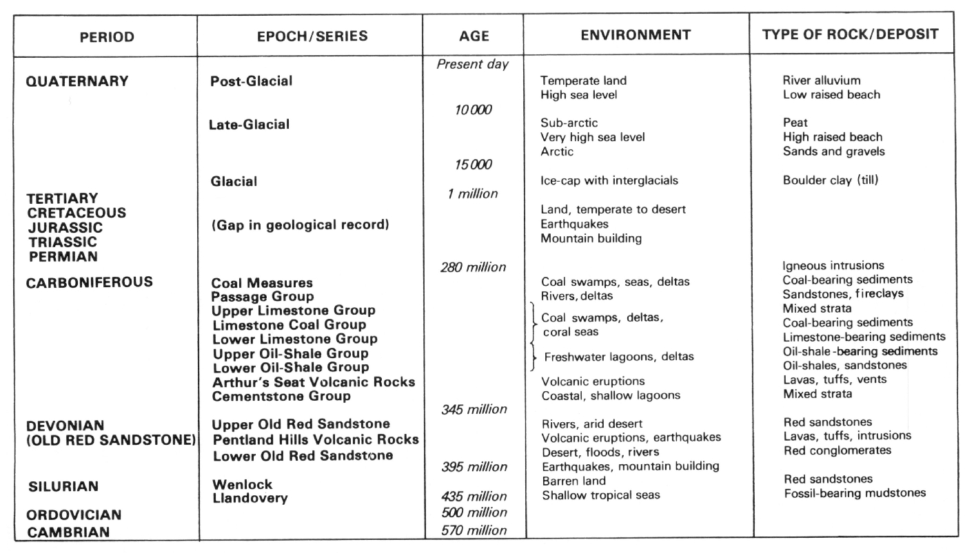
The sediments exposed along the shore between Silverknowes and Newhaven belong to the Lower Oil-Shale Group (Holkerian–Asbian) of the Lower Carboniferous Calciferous Sandstone Measures. These beds rest upon the Arthur's Seat Volcanic Rocks
In northern Edinburgh the Lower Oil-Shale Group is folded into a dome with the underlying
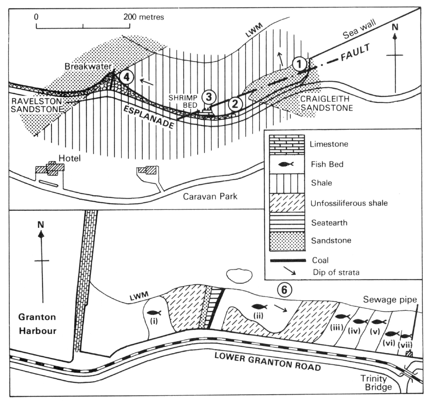
Excursion A - Granton shore
This excursion can only be undertaken at low tide; total time 2 hours.
1. Craigleith Sandstone
From West Shore Road, just west of the Granton Gasworks
2. Bituminous Shale
Directly overlying the
3. The Granton Shrimp Bed
The sequence overlying the bituminous shales contains three thin dark blue-grey calcareous horizons separated by shales (Briggs and Clarkson, 1983). Each horizon consists of thin organic laminae alternating with dolomite. The uppermost horizon, up to 30 cm thick, rests directly on a shale which in places is highly disturbed with NW-trending parallel folds normal to direction of slumping. The troughs of some 10 cm amplitude are filled with contorted material of the shrimp bed. Above this is a brecciated horizon, containing fragments of marine fossils, succeeded by finely laminated calcareous shrimp-limestone once more.
The upper calcareous bed contains abundant specimens of crustaceans; common Waterstonellagrantonensis, rarer Crangopsis, and Anthracophausia, and very rare Tealliocaris. There are also hydroids which like the crustaceans, are preserved in fluorapatite. Palaeoniscid fishes are sometimes found, and several specimens of a conodont-bearing animal have been recorded. These fossils are found only in isolated patches a few metres across and the locality is now largely worked out, the bulk of the fossiliferous material having been removed to the Royal Museum of Scotland in 1985.
The site is now protected as an S.S.S.I. under the vigilance of the Park Patrol. It is illegal to hammer these exposures. Shrimp-bearing blocks may however be picked up amongst the pebbles on the beach.
4. Western Breakwater
Follow the esplanade as far as the point or walk along the pebble and sand beach. Sandy ribs with shaly partings dipping 12° WNW mark the base of the yellow
Return to West Shore Road via the esplanade.
5. West Side Granton Harbour: Wardie Shales and Coal (not shown on map)
From Granton Harbour walk westwards along the shore
Apart from the
Excursion B - Shore East of Granton Harbour
6. Wardie Shales
This excursion can only be undertaken at low tide: total time 1.5 hours.
This section in the Wardie Shales was the source of many of the fishes described in the early nineteenth century by Agassiz, and later by Traquair (1887–1914), who published an extensive faunal list in 1903. The sequence was detailed by Mitchell et al. (1962) and later by Wood (1975) who collected many fossil fishes from a particular horizon.
Much of the succession is of shale with ironstone nodules but there are some thin ostracod-bearing limestones. Some of the nodules bear fish remains but the vast majority contain only coprolites usually of spiral form. This stretch of shore is rather contaminated and it is recommended that any nodules should be boiled before breaking open to remove effluent.
The succession dips eastwards at about 10°. The sequence, as given by Mitchell et al. and amended by Wood (1975), is as follows:
| Fish Bed (vii) | 7.6m | |
| Black shales with ironstone | Fish Bed (vi) | 5.0 m. |
| Nodules containing fish remains | Fish Bed (v) | 4.7 m. |
| Fish Bed (iv) | 2.0 m. | |
| Fish Bed (iii) | 0.9 m. | |
| Coprolitic bituminous shale (beds not exposed) | 7.6 m. | |
| Black shales with thin limestone. Lingula and bivalves (beds largely unexposed but thin tuff bed 2.5 cm visible) | Fish Bed (ii) | 3.0 m. |
| 1.0 m. | ||
| Nodular seatearth | 1.4 m. | |
| Yellow sandstone | 3.5 m. | |
| Unfossiliferous argillaceous beds with nodules; grey papery shale | 6.4 m. | |
| Dark papery shale | Fish Bed (i) | 2.1 m. |
The lower part of the succession below the
Eastwards from the sandstone are the most productive fish-bearing beds (especially Beds v-vii), with many ironstone nodules. Different types of nodules can be referred to specific beds. Many such nodules lie in abundance amongst the pebbles though the vast majority contain only coprolites.
The fishes that have been recorded are:
Cosmoplychius strialus (Ag) [most abundant]
Nemaloplychius greetlocki (Ag) [most abundant]
Elonichthys robisoni (Hibb) [most abundant]
Elonichthys puntatus (Ag)
Gonalodus punctatus (Ag) [most abundant]
Eurynothus crenatus Ag [most abundant]
Rhadinichthys brevis Traq
Wardichthys ornatissimus
Cladodont undet
Ctenacanths undet.[most abundant]
Tristychius sp. nov.
Acanthodes sulcatus Ag
Rhizodus hibberti (Ag in Hibb)
Megalicthys sp.
'Ophriderpelon'
East of the sewage pipe exposures are few and mud and the debris of new construction cover the beds. Return to Granton Harbour.
E.N. Clarkson