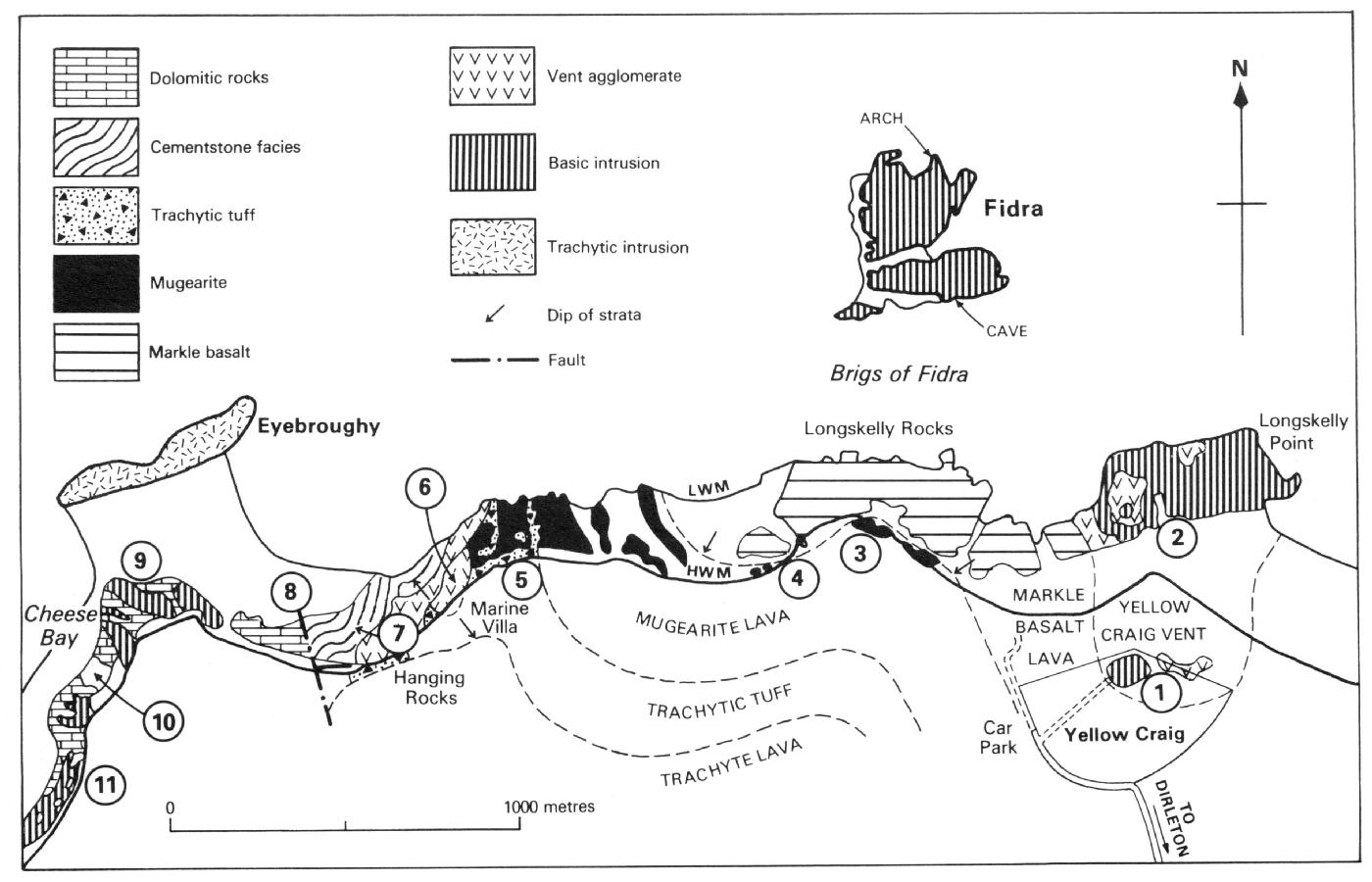
North Berwick Excursion C—Yellow Craig to Cheese Bay (Route: (Map 12) )
A.D. McAdam
1 Yellow Craig: vent intrusion and agglomerate
The excursion starts from the Yellowcraig car park
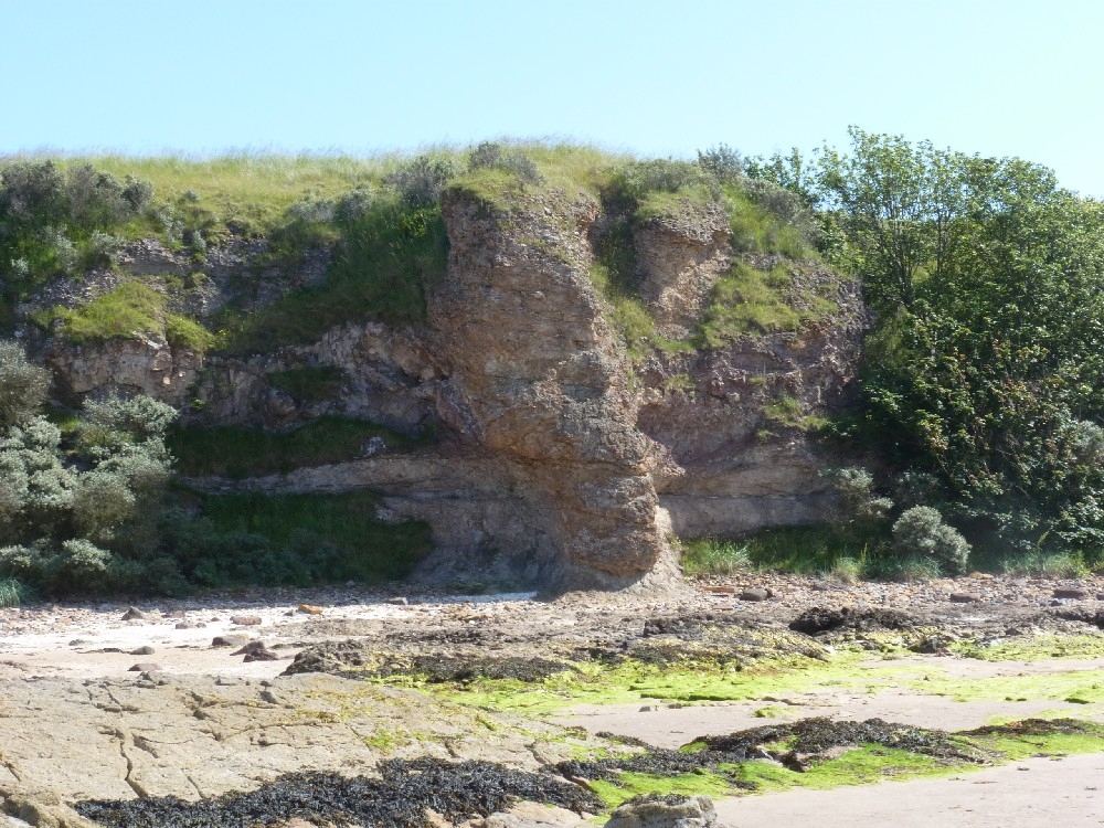
2. Longskelly Point: vent and concentric structure
Proceed due north across low sand dunes and the beach sand to the wave-cut platform of Longskelly Point. The east end of this platform is an intrusive sheet of black microporphyritic olivine-basalt. In the absence of contacts it is not clear whether the sheet was intruded entirely within the vent or extended into the flanks of the volcano. Note the prominent jointing and poorly formed columns in the hard, fissile basalt. Towards the west end of the wave-cut platform there occurs a concentric structure lying within the vent, possibly caused by collapse. Standing on the basalt plug some 25 m across in the centre of this structure, one can see concentric ridges and hollows formed by alternating hard basalt and soft agglomerate. Here also the greenish vent agglomerate contains fragments of various lithologies. The vent margin lies along a curved hollow where vent agglomerate cuts across Markle basalt lava the lava distinguished by its numerous large feldspar phenocrysts.
Offshore islands
At this point it is worth pausing to look at the four islands which enhance this coastline. Lying just offshore, Fidra is a thick sill of microporphyritic olivine-basalt, note the fine columnar structure in the basalt, the natural arch on the far side, and the low raised beach and cave on the near side. To the east the rocky Lamb is probably part of the same columnar basalt sill. Further east still, the rounded Craigleith is an essexite laccolith, and the vertical-cliffed Bass Rock is a phonolite volcanic plug. Also prominent to the south-cast is another phonolitic plug forming the conical North Berwick Law.
3. Longskelly Rocks: markle basalt and mugearite lavas
For the next 800 m the rocks on the foreshore consist of Markle basalt lava, dipping gently to the south. Round the point opposite Fidra, the junction between Markle basalt and the overlying mugearite lava to the south can be traced near H.W.M. Contrast the angular appearance of the grey. Fissile, non-porphyritic mugearite with the rounded appearance of the darker grey, crumbly Markle basalt containing numerous large feldspar and small olivine phenocrysts. The upper part of the basalt lava is autobrecciated and has amygdales and calcite veins. The high level of the wave-cut platform suggests formation during a higher post-Glacial sea level rather than at present.
4. Small intrusive plug
Located below a 'Power Cable' sign is a neat oval plug of hard black basalt. 5 m by 10 m. intruded into Markle basalt lava. The intrusion has a pale chilled margin which can be traced along the somewhat irregular contact with the lava.
5. Marine Villa: volcanic succession
See also addendum below
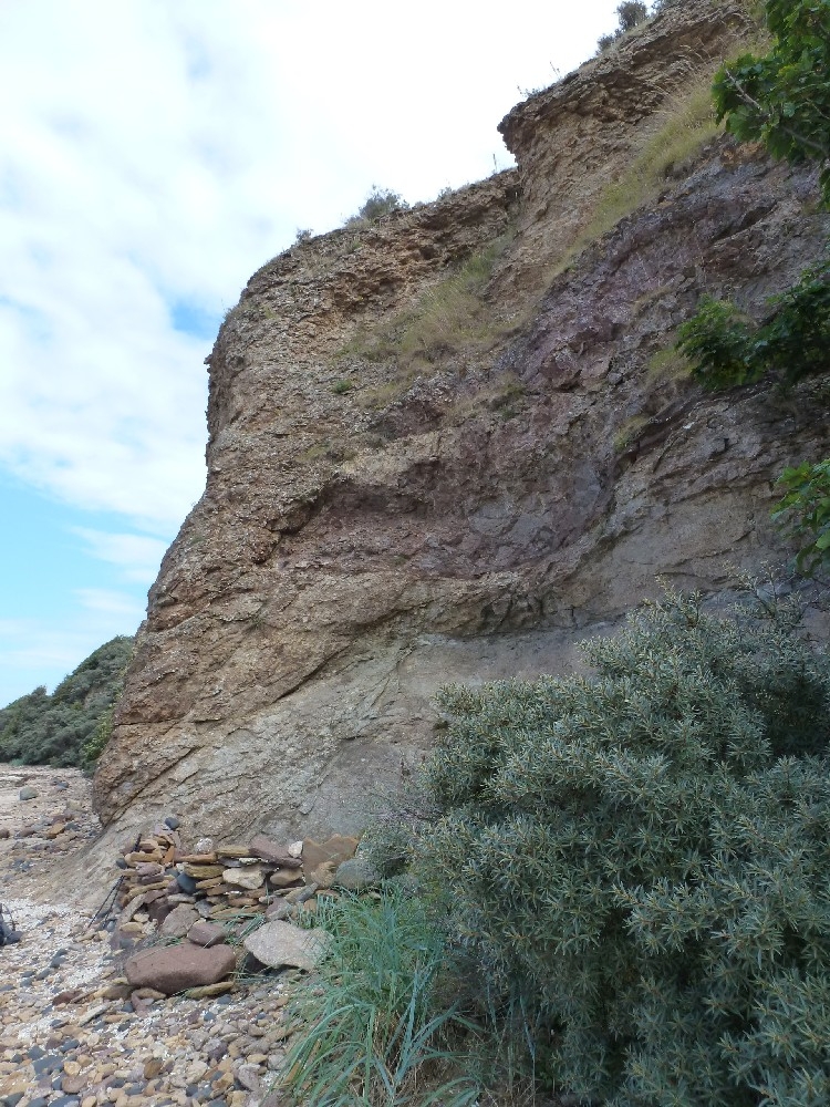
Towards Marine Villa, due to a change of strike, the volcanic succession of Markle basalt, mugearite and trachytic tuff is traversed in ascending order. Here the mugearite lava is very well exposed, and in it can be seen sparse feldspar phenocrysts, concentric iron-banding with bleached centres, and numerous calcite veins. Note here also the storm beaches of black microporphyritic basalt boulders, brought by currents across from Fidra; during exceptionally low tides the connecting Brigs of Fidra may be exposed. Opposite Marine Villa, used by R.L. Stevenson as the location for his short novel The Pavilion on the Links, the junction of mugearite lava and overlying red bedded trachytic tuff is repeatedly exposed by a combination of low dip, slight folding and irregular erosion. The irregular slaggy amygdaloidal top of the lava has been preserved here by the overlying tuff. The absence of a bole of red fossil soil indicates that the tuffs were deposited soon after the lava. Sections of the trachytic tuffs in low cliffs show alternation of coarse and fine bands and an agglomeratic base. Slickensided planes with slight movement are indications of the faulting occurring further west.
6. Weaklaw Vent
See also addendum below
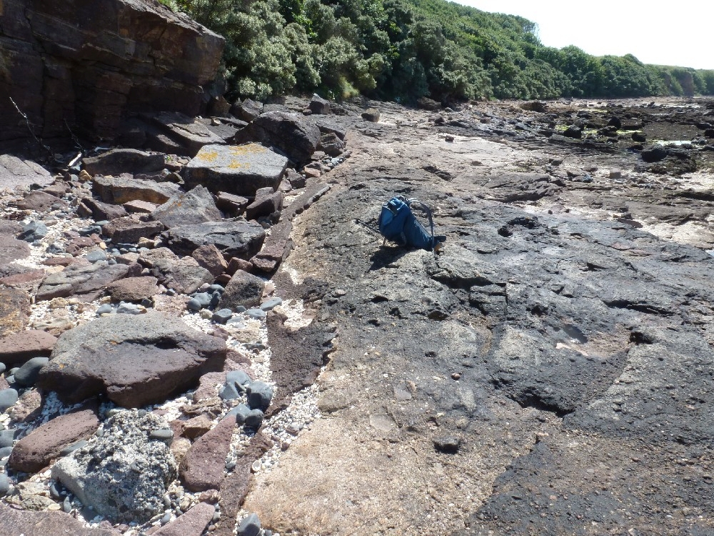
Just beyond a second 'Power Cable' sign the red bedded tuffs are truncated along a silicified plane, dipping at 30 degrees to the west, well-exposed at H.W.M. and in the low cliffs behind. This is taken as the edge of a small vent, about 100 m across, filled with reddish-brown poorly bedded sandy tuffaceous breccia containing grey cementstone blocks. Along H.W.M. beyond the vent are exposures of soft, yellow, bedded dolomitic tuffs containing blocks of trachyte, some markedly feldspar-phyric.
7. Hanging Rocks: intrusion breccia
See also addendum below
Intruded along a NE–W fault separating the trachytic tuffs from cementstone facies sediments is a yellow dolomitic breccia with large hornfelsed shale blocks. The south-east margin of this intrusion breccia is spectacularly displayed in two bluffs as planes dipping at 60 degrees and 45 degrees, which leave the breccia 'hanging' against the bedded volcanic rocks in the cliffs behind. By the caves in the next bluff, 5 m of rotten, purple, vesicular, porphyritic trachyte lava with an irregular base rest on 8 m of purple and cream, bedded trachytic tuff with agglomeratic bands.
8. Cementstone facies sediments and synclinal ring structure
See also addendum below
From the slopes above the caves there are fine views of gentle folding in bedded sediments on the foreshore. Close examination on descending to the shore shows that these are cementstone facies sediments, consisting of thin red-weathering, grey cementstones, some nodular, grey siltstones and mudstones, in which plant fragments and rarely shells may be found. Minor folding and faulting can be discovered within the larger structures. Just to the west, and separated from the sediments by a fault, there is an asymmetric synclinal structure, possibly caused by collapse. Prominent hard dolomitic bands alternating with softer tuffaceous bands pick out dips of up to 40° in the structure.
9. Point opposite Eyebroughy: basalt sill
A thin irregular sill of microporphyritic basalt has been intruded into dolomitic and tuffaceous sediments. The sill, cut by erosion into several parts, displays fine columnar structures varying from horizontal to vertical. Eyebroughy, a rocky tidal islet, consists of trachyte, thought to be intrusive.
10. Cheese Bay: Shrimp Bed
In the bay to the south, which reputedly owes its name to the wreck of a ship laden with cheese, gently folded sediments crop out. A band of hard red-weathering cementstone with estheriids is underlain by dark grey mudstones, black bituminous shales containing ostracods, fish scales and pyritised plants, finely colour-banded shales, and a thin fissile grey silty cementstone. This locality is noted for the occurrence of the shrimp
11. Cheese Bay Sill
Just to the south another microporphyritic basalt sill is similarly intruded into dolomitic sediments. In the bouldery area beyond, prominent isolated stacks of basalt capped by outliers of baked sediments show the development of white trap, druses and other phenomena produced by intrusion of basaltic magma into carbonate rocks. The excursion can be completed by continuing south to Gullane (3 km) from where a service bus goes to Edinburgh, or by returning along the shore to Yellowcraig (4 km).
12. Dirleton Castle: Trachyte Lava
Worthy of a visit in Dirleton Village is the ruined castle built in the 13th to 15th century. The castle
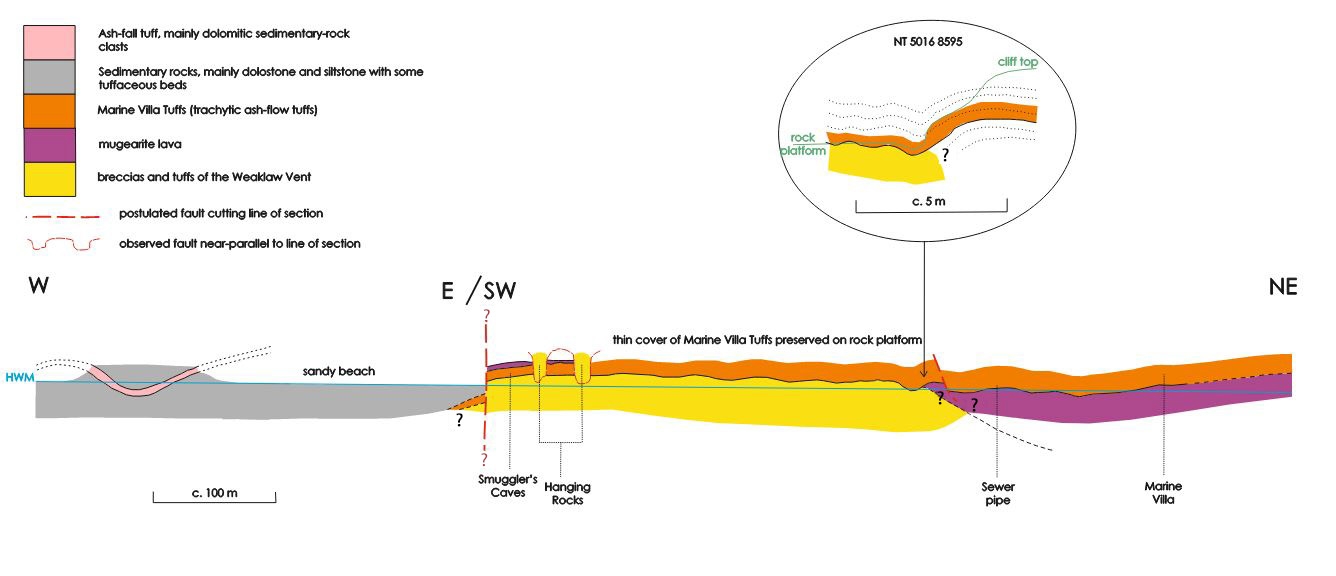
Relative ages of the Weaklaw Tuffs, the Hanging Rocks breccias and the Marine Villa Tuffs - Addendum to localities 5, 6, 7 and 8.
By David Stephenson, formerly BGS Edinburgh, October 2022
The field evidence
The rocks at localities 5, 6 and 7, between Marine Villa and the Hanging Rocks have been described in great detail and interpreted in modern terms by Upton et al. (2019) and Upton et al. (2020). However, their field relationships and relative ages have remained enigmatic. This is in part because of the great difficulty of tracing near-horizontal geological boundaries on an extensive intertidal rock platform that is mostly covered in seaweed.
The section was first described in detail by Day (1916, 1923), who clearly made a good attempt to map the rock platform, especially in his later paper (Day, 1923, fig.1). The very small-scale map (
There are three main units
- mugearite lava, at the local top of the Hailes Member,
Garleton Hills Volcanic Formation (GHVF); - well-bedded trachytic tuffs, now known to include ignimbrite ash-flows, termed the Marine Villa Tuffs by Upton et al. (2020) and forming the local base of the Bangley Member, GHVF;
- the Weaklaw Tuffs, forming the
Weaklaw Vent (Upton et al., 2019).
The Marine Villa Tuffs are clearly seen to rest upon a perfectly preserved, spiky top of the mugearite lava at Locality 5 and for some 150 m to the west at the base of the cliffs. It is the relationship of these two units to the
The only direct detailed evidence is well exposed within Locality 6 at NT 5016 8595, about 50 m south-west of a rusty ?sewer pipe and directly below a brick-built observation post on the cliff top. However, this exposure has been misinterpreted by both Day (1923) and McAdam (1986). Both recognised the edge of the
Closer examination shows that this is not the case. Bedding in the Marine Villa Tuffs does steepen to c. 30 degrees, towards the Weaklaw Tuffs but this steepening is very local and, at the base of the cliff, the base of the Marine Villa Tuffs can clearly be seen to be folded back up to rest upon the Weaklaw Tuffs at a low angle i.e. there is an open syncline
We must conclude that the Marine Villa Tuffs overlie the Weaklaw Tuffs over a wide area and are therefore younger. However, the outcrop of the mugearite lava (Hailes Member) has been traced, beneath the Marine Villa Tuffs only as far west as the rusty sewer pipe, a mere 50 m from the outcrop of the Weaklaw Tuffs but it is not seen in contact with them and, at the key locality, the Marine Villa Tuffs rest directly on the Weaklaw Tuffs with no intervening mugearite. So, the relationship between the mugearite lava and the Weaklaw Tuffs is not known
Sequence of main volcanic events
- Eruption of the small Weaklaw volcano, as described by Upton et al. (2019), was probably contemporaneous with petrographically and geochemically similar basanitic volcanoes associated with the basal North Berwick Member of the GHVF (McAdam and Tulloch, 1985; Upton, 2003, p 54). A low but upstanding volcanic edifice with gentle slopes probably survived for some time, until….
- After possibly a significant time interval, eruption of the mugearite lava at the top of the Hailes Member. The lava is not seen in contact with the Weaklaw Tuffs, so does the mugearite lap up against the remains of the Weaklaw volcano below current erosion level or maybe it was deflected around it?
- The Marine Villa Tuffs were deposited, mainly by pyroclastic flow, directly upon a very fresh, perfectly preserved, rubbly to spiky top of the mugearite lava. There is no sign of reddening, weathering or erosion of the mugearite, so this was almost certainly after only a short time interval. The gently undulating hummocky surface of the tuffs is most probably primary, possibly also reflecting underlying topography on the top of the mugearite but the contact is generally subhorizontal and very close to low-water mark on the rock platform. Cross-bedding in the pyroclastic flows consistently indicates flow towards the Weaklaw volcano. Did the flows completely overtop what was left of the volcano or were they too deflected around it - or maybe both? It seems possible that the little open syncline in the Marine Villa Tuffs at the key locality might be a primary feature, at least in part i.e. is it a result of the basal pyroclastic flow 'colliding' with a low-angled remnant of the Weaklaw volcanic edifice?
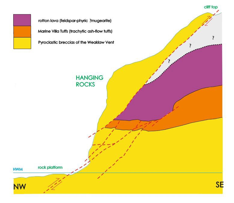
Geological relationships at the Hanging Rocks
Some 250 m west of the first exposures of the Weaklaw Tuffs, at the Hanging Rocks (Locality 7), two masses of pyroclastic breccia form prominent bluffs protruding from the full height of the cliff section
The breccias that compose the Hanging Rocks are indistinguishable from the pyroclastic breccias of the
So, the Hanging Rocks breccias are truly ‘hanging’ in both a topographical and a geological sense i.e. they expose the hanging wall of a high-angle reverse fault-zone, parallel to and possibly controlling the location of the cliff line. Breccias of the
Tuffs within the sedimentary sequence west of the Hanging Rocks
West of the exposures of the
Ages of events
The failure of anyone over the past 100 years to recognise the syncline at the key locality, or to fully appreciate the subhorizontal, unconformable thin cover of Marine Villa Tuffs over much of the intertidal rock platform, has resulted in a perpetuation of Day's false assumption that the Weaklaw Tuffs overlie, and/or possibly cut through, the Marine Villa Tuffs and hence are younger. In the light of the field evidence presented here, it is now clear that the assumption by Upton et al. (2019) that the Weaklaw Tuffs were a product of a much later event than the Garleton Hills volcanic episode cannot be substantiated.
The relatively primitive basanitic nature of lava bombs and fragments within the tuffs and breccias of the
Thin beds of tuff within a sedimentary sequence to the west of the Hanging Rocks post-date the GHVF and might be associated with 'cryptovents' around Cheese Bay.
Addendum references
Day, T.C. 1916. The breccias of Cheese Bay and the yellow conglomerates of Weaklaw. Transactions of the Edinburgh Geological Society, Vol. 10, 261–275.
Day, T.C. 1923. A new volcanic vent and other new geological features on the shore, Weaklaw, near Gullane. Transactions of the Edinburgh Geological Society, Vol. 11, 185–192.
McAdam, A.D. 1986. North Berwick: Excursion C Yellow Craig to Cheese Bay. In A.D. McAdam and E.N.K. Clarkson (editors) Lothian Geology: An Excursion Guide, Scottish Academic Press, Edinburgh, 103–108.
McAdam, A.D. and Tulloch, W. 1985. The Geology of the Haddington District. Memoir of the British Geological Survey, Sheet 33W and part of 41 (Scotland), 99pp.
Upton, B.G.J. 2003. North Berwick Coast, East Lothian. In Carboniferous and Permian Igneous Rocks of Great Britain North of the Variscan Front, (D. Stephenson, S.C. Loughlin, D. Millward, C.N. Waters and I.T. Williamson), Geological Conservation Review Series, No. 27, Joint Nature Conservation Committee, Peterborough, pp. 47–55.
Upton, B.G.J., Odling, N., Kirstein, L.A., Underhill, J.R., Puziewicz, J.R., Ntaflos, T., Bagiński, B., Hillier, S., Andersen, J.C., Rollinson, G.K. and Perrillat, J.-P. 2019. The
Upton, B.G.J., Kirstein, L.A., Odling, N., Underhill, J.R., Ellam, R.M., Cayzer, N. and Clarke, B.A. 2020. Silicic volcanism in the Scottish Lower Carboniferous; lavas, intrusions and ignimbrites of the