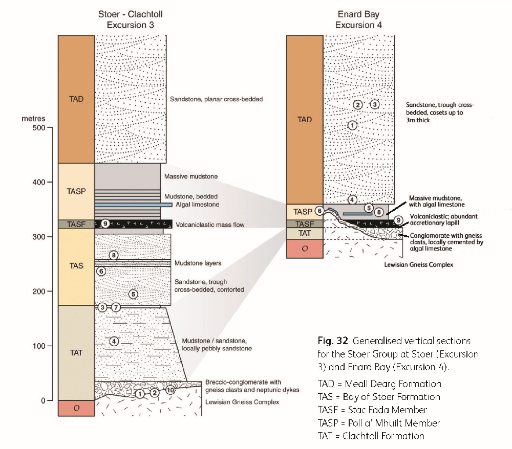
Excursion 3 Stoer Group at Stoer Peninsula
Maarten Krabbendam
Purpose: To examine the stratigraphy and sedimentology of the late Mesoproterozoic
Aspects covered: Basal unconformity with breccia and neptunic dykes; fluviatile and lacustrine deposits (
Maps: OS: 1:50,000 Landranger sheet 15 Loch Assynt; 1:25,000 Explorer sheet 442 Assynt and Lochinver. BGS: 1:50,000 107W Point of Stoer.
Terrain: Mainly coastal outcrops with relatively easy access. Most outcrops can be visited at any state of the tide, with some exceptions (e.g. Locality 3.1). Many boulders and bedding planes can be extremely slippery, especially below high tide mark. The excursion is not recommended during stormy conditions.
Time: A full day allows leisurely study; if pressed, a half day would suffice.
Access: There are no access constraints for this excursion, but it is largely on or near crofting land and care must be taken with livestock – dogs should be kept on a lead at all times. Please note that this is a very popular excursion, and that the outcrops should not be hammered.
Locality 3.1 Bay of Clachtoll: Stoer Group – Lewisian Gneiss Complex unconformity (low tide only). [NC 0404 2702]
Park in the car-park near Clachtoll beach [NC 0395 2730)], which has public toilets and a Ranger Hut with a small display on the local natural history. A' Chlach Thuill (the 'Split Rock') is visible on the shore to the south-west. From the car-park, walk across the dunes and then the beach in a southerly direction
At the southern end of the beach, cobbly breccio-conglomerate – the basal
If the tide is low, follow the beach south-east to a wide sandy gully, and follow this south to a small bay at
Lewisian gneiss occurs on the east of this little bay, while sandstone occurs to the west; the bay marks a fault. From here, climb over the gneiss knoll to the east, following an old fence, turn right through a gap and right again to a small south-east-facing cliff.
Locality 3.2A Stoer Group – Lewisian Gneiss Complex unconformity. [NC 0412 2672]
The small cliff of Lewisian gneiss shows numerous veins of red mudstone and locally fine sandstone, injected into cracks and fractures. Locally, the gneiss is brecciated, with angular blocks surrounded by a matrix of injected mudstone. Some of the most photogenic examples occur in loose boulders below the cliff. In the gully below the cliff, a small stream marks the boundary between a mafic Scourie Dyke and brecciated, faulted Lewisian gneiss. On the far (western) side of the cliff, subhorizontal slickensides (suggesting a component of strike slip movement) occur in mudstone, plastered against gneiss. The cliff and gully mark a fault, which operated during
Locality 3.2B Basal Stoer Group breccio-conglomerate. [NC 0412 2666]
Cross the stream and follow a sheep path for c.50 m to the south, then clamber over some gneiss until you see an outcrop of conglomerate. This conglomerate is the basal part of the
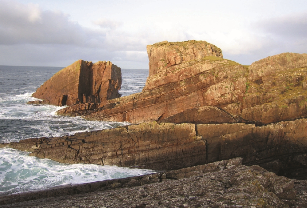
Locality 3.3 A' Chlach Thuill ('Split Rock'). [NC 0384 2673]
Retrace your steps for about 100 m and then head west over grass towards a prominent rocky knoll on the peninsula. This is A' Chlach Thuill ('Split Rock';
Retrace your steps to the beach of Bay of Clachtoll. Looking north, note the clear change of landscape that coincides with the unconformity between Lewisian gneiss and the
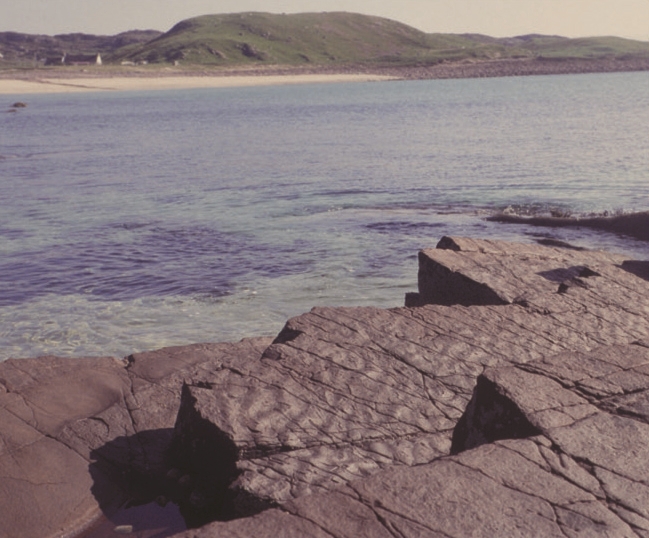
Locality 3.4 Bay of Clachtoll beach: Clachtoll Formation . [NC 0405 2715]
The large knoll in the middle of Bay of Clachtoll beach consists of thick bedded, red muddy sandstone, typical of the
Outcrops at high-water mark just north of the Salmon Bothy show thinner bedded muddy sandstone, locally with desiccation cracks on bedding surfaces, indicating periods of subaerial exposure.
From here, follow the coast north to a monument to the Reverend Norman MacLeod, founder of the Normanite Presbyterian movement. The monument is made from Ledmore Marble (see Excursion 10). Follow the 'walkers' signs through the various gates and stiles past the croft of Clachtoll Cottage. Beyond the croft follow a path over grass, then turn west to a patch of boulders with low outcrops.
Locality 3.5 Aird na Mòine: Bay of Stoer Formation . [NC 0361 2726]
The low outcrops here comprise medium-coarse pink sandstone (
Work your way northwards, following the top of the outcrops, past a perched erratic of Lewisian gneiss. Extensive, sloping bedding planes alternate with small cliffs; head towards the second of these.
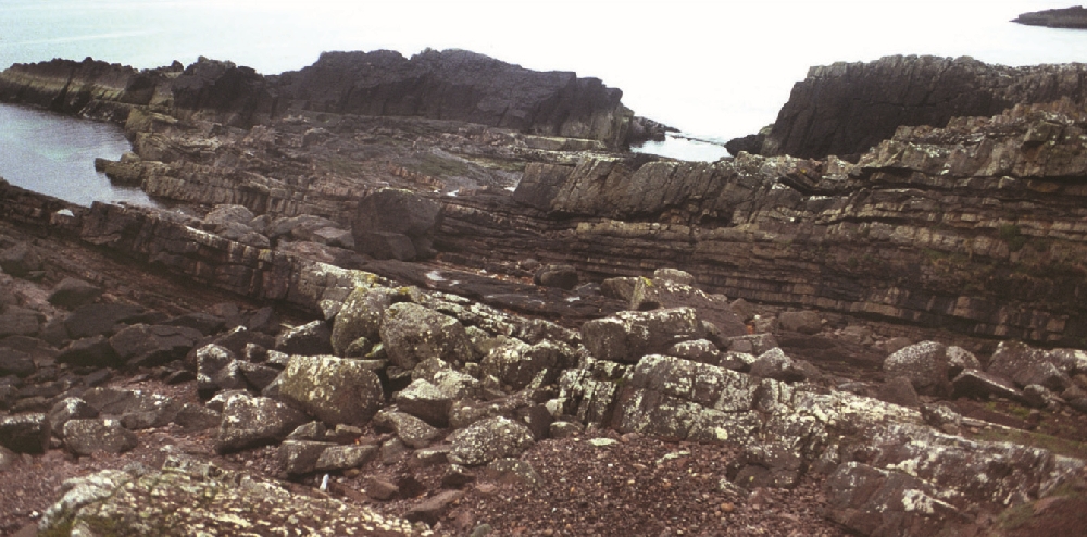
Locality 3.6 Sgèir na Tràghad: Bay of Stoer Formation . [NC 0358 2751]
A series of mudstone–sandstone alternations (c.10 cm scale beds), bounded at top and bottom by thicker bedded sandstone, are seen at this locality
Continue northwards past An Dun, a ruined Iron Age broch, to the cobble beach of Bay of Stoer. Continue along the beach to reach outcrops at sea level on the north-west side of the bay.
Locality 3.7 Bay of Stoer: Clachtoll – Bay of Stoer formation boundary. [NC 0379 2834]
Take care at this locality as the bedding planes can be very slippery. The outcrops forming the wave-cut platform are in the
Go a short distance to the east and ascend a grassy slope towards a wall; follow the path to the west along the wall. At the end of the wall, go through the gate; after about 50 m cross a small stream.
Locality 3.8 [NC 0355 2853]
The same thin mudstone–siltstone beds are exposed here as at Locality 3.6, showing considerable lateral extent. From here, continue west along the path to a rocky promontory.
Locality 3.9 Stac Fada: Stac Fada Member . [NC 0333 2854]
The promontory marks the
There appear to be two volcaniclastic units in the area (although Stewart [2002] suggests that these are the same unit repeated by faulting). The upper, thickest unit is seen in the north to be wedged in with sandstone; some metres above this lies a raft of sandstone some 20 m long. Smaller rafts, some of which are contorted, occur to the south. The sandstone below the lowest unit is locally strongly warped, especially in the south.
A number of different interpretations have been proposed for the exact genesis of the
In all cases, the presence of accretionary lapilli, which are formed as airborne ash particles coalesce into 'volcanic hailstones', suggests a component of direct ash fall, since lapilli are relatively fragile and are unlikely to survive redeposition. Such ash falls would, in all cases, follow the main depositional event, be it peperitic, mud flow, pyroclastic flow, or impact-related.
West of Stac Fada, the remainder of the
Take the path back, and keep following tracks past a white cottage left of the beach to meet the tarred road. Go left for 100 m then turn right on the tarred road towards Stoer
Locality 3.10 Stoer cemetery: basal Stoer Group conglomerate. [NC 0411 2842]
Basal breccia and conglomerate, with gneiss cobbles up to 60 cm. across, directly overlie gneiss. The gneiss does not show signs of weathering. Notice the strong pre-
Return to the road, go left and follow the road back to Clachtoll Beach car-park.
Locality 3.11 Culkein – Port Feadaig: Stoer Group /Torridon Group unconformity. [NC 042 329]
From Clachtoll, drive north through Stoer, take the first left towards the lighthouse, then continue north towards Culkein. As you approach the sea, park in a lay-by approximately 50 m before (east of) a white cottage. There is a parking place for one or two minibuses at
On the eastern side of the bay are strata of the
On the eastern side of the bay
Also in this area are large metre-sized boulders (not in situ) of conglom-erate, mainly with rounded clasts of Lewisian gneiss in them, suggesting moderate transport distance. The boulders are presumably derived from the basal
Just west of the centre of the bay is a somewhat overgrown outcrop with gently north-east dipping strata of laminated siltstone, mudstone and sandstone, belonging to the
Further north, the
To the east of Port Feadaig is a good section through the