Excursion 11 Kilsyth and Denny
Peter Craig
Purpose: To demonstrate the stratigraphy of the north-eastern outcrops of the
Maps: OS 1:50,000 Sheet 64 Glasgow; OS 1:25,000 Sheet 348 Campsie Fells; BGS 1:50,000 Sheet 31W Airdrie; locality maps figures 11.1, 11.2.
This excursion illustrates some lava members of the
The other factor to be considered in unraveling the lava stratigraphy is the degree of block faulting that occurred during and after the cessation of volcanic activity. This is particularly relevant to the interpretation of the Carron valley section (Itinerary 11B).
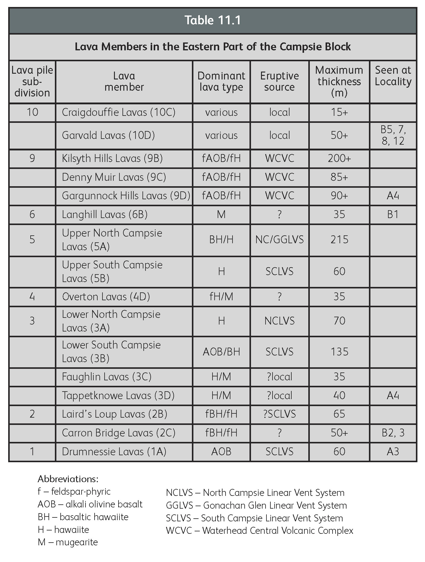
| Lava pile sub-division | Lava member | Dominant lava type | Eruptive source | Maximum thickness (m) |
Seen at Locality |
| 10 | Craigdouffie Lavas (10C) | various | local | 15+ | |
| Garvald Lavas (10D) | various | local | 50+ | B5, 7, 8, 12 | |
| 9 | Kilsyth Hills Lavas (9B) | fAOB/fH | WCVC | 200+ | |
| Denny Muir Lavas (9C) | fAOB/fH | WCVC | 85+ | ||
| Gargunnock Hills Lavas (9D) | fAOB/fH | WCVC | 90+ | A4 | |
| 6 | Langhill Lavas (6B) | M | ? | 35 | B1 |
| 5 Upper North Campsie Lavas (5A) | BH/H | NC/GGLVS | 215 | ||
| Upper South Campsie Lavas (5B) | H | SCLVS | 60 | ||
| 4 | Overton Lavas (4D) | fH/M | ? | 35 | |
| 3 Lower North Campsie Lavas (3A) | H | NCLVS | 70 | ||
| Lower South Campsie Lavas (3B) | AOB/BH | SCLVS | 135 | ||
| Faughlin Lavas (3C) | H/M | ?local | 35 | ||
| Tappetknowe Lavas (3D) | H/M | ?local | 40 | A4 | |
| 2 | Laird's Loup Lavas (2B) | fBH/fH | ?SCLVS | 65 | |
| Carron Bridge Lavas (2C) | fBH/fH | ? | 50+ | B2, 3 | |
| 1 | Drumnessie Lavas (1A) | AOB | SCLVS | 60 | A3 |
| Abbreviations: | |
| f – feldspar-phyric | NCLVS – North Campsie Linear Vent System |
| AOB – alkali olivine basalt | GGLVS – Gonachan Glen Linear Vent System |
| BH – basaltic hawaiite | SCLVS – South Campsie Linear Vent System |
| H – hawaiite | WCVC – Waterhead Central Volcanic Complex |
| M – mugearite |
Itinerary 11A: Berryhill, north of Kilsyth
Logistics: This itinerary starts in strata at the base of the volcanic pile, exposed to the east of the unclassified Tak-Ma-Doon Road between Kilsyth and Carron Bridge. The road is unsuitable for coaches except for the first 1.5 km from the Kilsyth end. Coach parties should walk the last 500 m or so north to the first locality at the road bend just north of Berryhill, now farmed from Glenhead, High Banton. Cars may be parked in the lay-by area
Locality 11.1 [NS 7300 8025] North of Berryhill: subvolcanic sill of feldspar-phyric basalt with xenoliths.
Immediately east of the bend in the road are exposures of what was formerly interpreted as the earliest lava flow interdigitated with prevolcanic sandstones. The rock is a fresh, feldspar-phyric basalt with pronounced ophitic texture. The freshness, texture and presence of many xenoliths are now known to be typical of rocks intruded into the sedimentary strata underlying the lava pile. These outcrops are now regarded as the eastern extremity of a sill-like body that can be traced westwards beneath the volcanic pile for a distance of 900 m. The exposures reveal the localised presence of many xenoliths of indurated sandstone and mudstone, especially in the higher exposures.
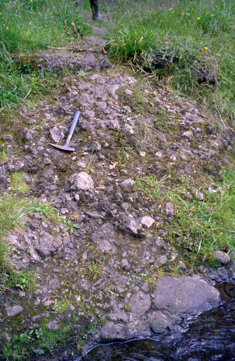
Locality 11.2 [NS 7312 8035] Banton Burn: dolostones (cementstones) and mudstones of the Ballagan Formation .
In the Banton Burn section less than 200 m to the east, high-ferroan dolostone (cementstone), mudstone and some fine-grained sandstones of the
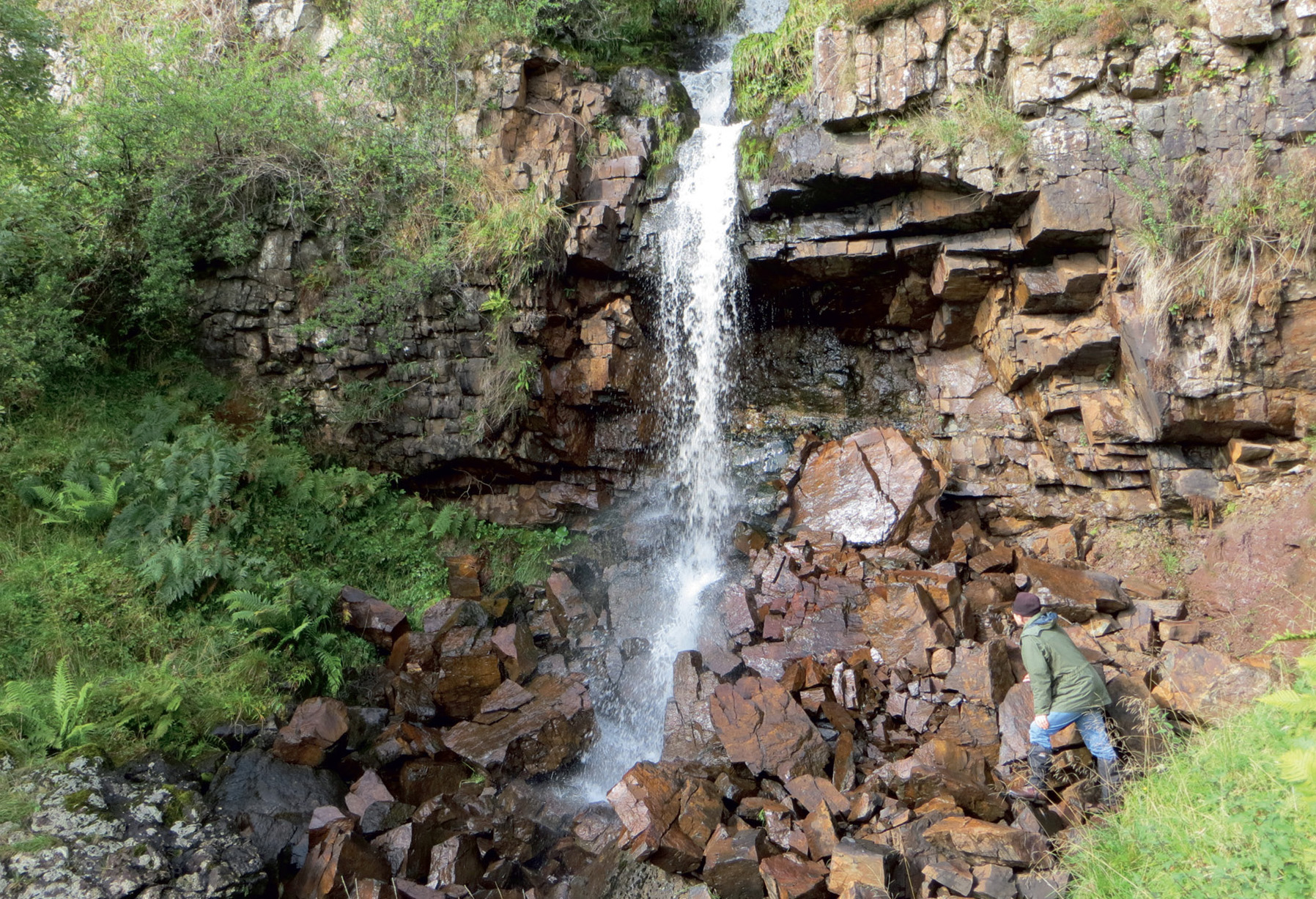
Locality 11.3 [NS 7305 8045] Berryhill waterfall: base of the volcanic pile and multiple dyke intrusion.
At first sight, the waterfall appears to represent a typical trap feature with more-resistant lava overhanging eroded and decomposed subflow scoria and pyroclastic rocks
Locality 11.4 [NS 7288 8070] North of Tak-Ma-Doon Road: mugearitic and hawaiitic lavas.
To the north of the lay-by, where the road swings sharply eastward, the steep slope rising above the road has several small exposures of platy-jointed mugearitic lava belonging to the Tappetknowe Lavas (3D in
Itinerary 11B : River Carron west of Denny
Logistics: If the Tak-Ma-Doon road has been followed from Berryhill to Carron Bridge, the landscape to the east of the road lacks continuous trap featuring at lower levels because the lava flows are of proximal facies. They tend to be irregular, slaggy bodies with a relatively high proportion of interflow scoriaceous and tuffaceous rocks. Park in the lay-by on the Carron Bridge to Denny road (B818) near Easter Langhill
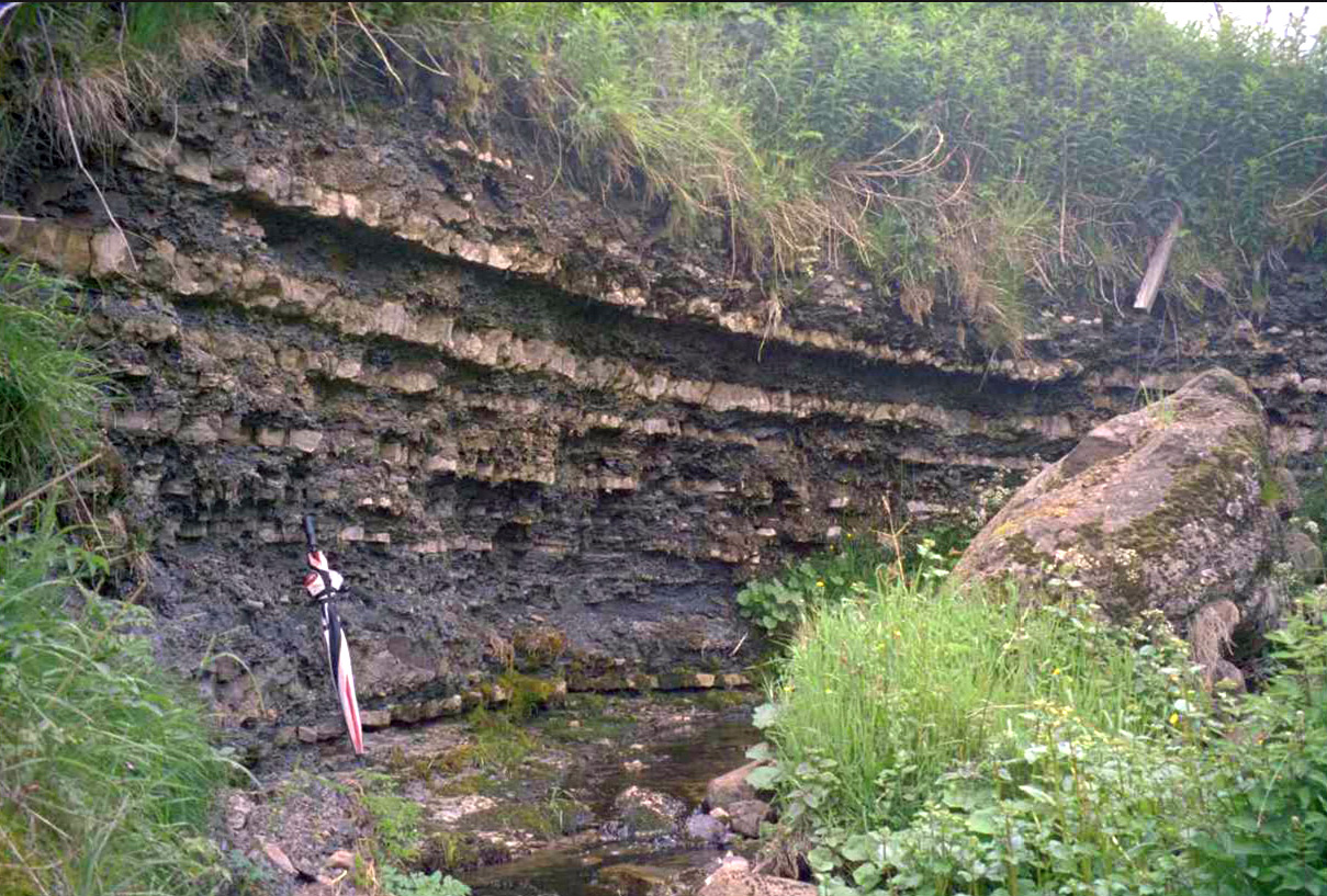
Locality 11.5 [NS 7730 8460] South to north bank of River Carron: dipping trap feature.
From about 400 m NNE of Langhill, a particularly thick flow of mugearite can be seen in the north bank of the river. It forms a 15 m-high trap feature dipping generally east. Apart from the heavily and irregularly jointed top and bottom metre or so, the lava is massive and displays coarse columnar jointing, more-typical of the thicker flows of less-evolved basalt and hawaiite of this area. Its unusual thickness and coarse jointing indicate that it is probably near source. It may have been emplaced in a lava lake. More-typical flow textures of mugearites in the Campsie Block reflect increasing viscosity with cooling and generation of the characteristic platy jointing by flowing. This is the basal flow of the Langhill Lavas (6B in
Locality 11.6 [NS 7745 8445] River Carron: non-porphyritic lava in faulted contact with feldspar-phyric lava.
This is one of the few localities in the Campsie Fells where the presence of a fault is clearly demonstrable and can be accurately located. A sizeable crag of feldspar-phyric lava rises from the river's edge on the south bank, while most of the river bed and north bank exposures are of mugearitic lavas of the Langhill Member. The line of the fault can be traced between the two lava types. The south bank lavas belong to the older Carron Bridge Lavas (2C in
Locality 11.7 [NS 7770 8425] River Carron: feldspar-phyric lava.
Feldspar-phyric lavas of the
Locality 11.8 [NS 7795 8403] River Carron: volcaniclastic breccia, probably in or near a vent.
These distinctive outcrops are readily examined from the north bank. They are interpreted as being separated from the lava outcrops immediately upstream by the Carron Glen Fault. With an estimated throw of 100 m, this fault has brought down to the east the topmost lavas in this part of the Campsie Block, the Garvald Lavas (10D in
Locality 11.9 [NS 7815 8390] River Carron: pillow lava.
To reach the next locality, follow the path that ascends the north side of Carron Glen, away from the river. Where the path descends again, and some 2 m before it levels out, turn sharp right and scramble down to the exposure at the river's edge. Small-scale pillowing of the lava is clearly displayed, while rather less-obvious pillowing is present in many of the microporphyritic lava exposures in the river bank for almost 100 m upstream. Pillowing is also apparent in the south bank exposure immediately opposite.
This distinctive structure indicates eruption of lava beneath or into water. The localised and rather poorly developed pillowing is probably indicative of the presence of shallow and discontinuous bodies of water at the time of eruption. The only other localities within the Campsie Block where pillowing has been observed lie at a similar stratigraphical level (10D in
Locality 11.10 [NS 7842 8378] Carron Glen: Midland Valley Sill-complex.
Return to the north bank path and continue to follow it downstream. Spheroidal weathering should be visible in the crags high above the path before it reaches its highest point. Such weathering is characteristic of the major quartz-dolerite sill that forms such a prominent topographic feature between the Wallace Monument to the NE of Stirling, and Myot Hill
Locality 11.11 [NS 7860 8350] Carron Glen: top of lava sequence.
As the path descends again, note the view back upstream where the river has cut a gorge into the lava flow sequence. At Locality 11.11 the path follows the top of an 8 m-thick lava flow that forms a steep cliff plunging down to the river on the right. On the left, a rather unstable and degraded exposure reveals the topmost strata of the lava pile at this locality. The lower part of the exposure is in soft, purplish weathered, scoriaceous rock, which probably represents the slaggy top of the thick flow beneath. The top 40cm or so of the section, however, are of flaggy-bedded, pale, medium-grained sandstone. This is the first non-volcanic sedimentary rock in the succession since those below the first lava flow, and signals the end of the eruptive episode.
Locality 11.12 [NS 7860 8343] River Carron: topmost lava flow.
Continue descending the path and take the right fork. Proceed down to the river for a view of the heavily jointed, locally platy-jointed, lava flow that here forms the topmost of the Garvald Lavas (10D in
Locality 11.13 [NS 7870 8323] River Carron: sedimentary strata above the lavas.
Whilst following the path downstream to the footbridge across the River Carron, the Garvald Burn can be observed flowing into the Carron from the south. The lower part of this stream section is unfortunately polluted and choked with rubbish and thus cannot be recommended. Just before crossing the Carron footbridge the outcrops on the south bank can be viewed across the river. They comprise sedimentary strata (
To reach Locality 11.14, cross the Carron footbridge and climb the north bank to the public road. Turn right along the road and follow it (with due regard to the hazardous bends) for about 600 m to the west, as far as the bridge across the Garvald Burn.
Locality 11.14 [NS 7811 8294] Garvald Burn: Kirkwood Formation siltstones.
The exposures upstream from this bridge
Locality 11.15 [NS 7807 8286] Kirkwood Formation conglomerates and siltstones.
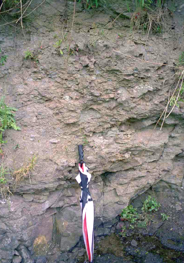
In this 4 m section, most of the rock is a coarse conglomeratic unit with rounded boulders up to 30 cm in diameter of a variety of lava types. The calcareous matrix is generally sparse but some thin lenses of sandstone and pebbly fine conglomerate are present locally. The upper part of the section appears to consist of largely non-volcaniclastic flaggy sandstones and siltstones, locally with conspicuous cross-bedding.
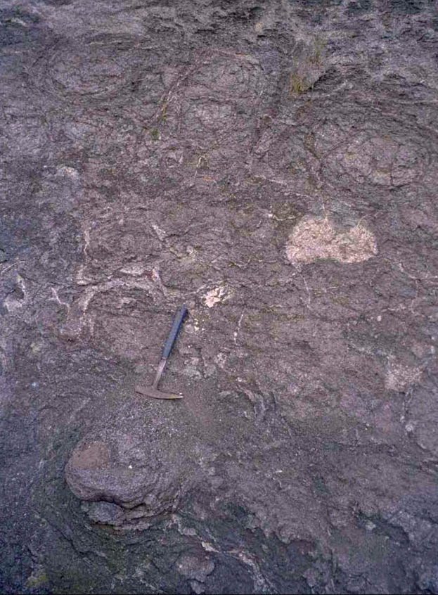
Locality 11.16 [NS 7789 8278] Garvald Burn: Clyde Plateau Volcanic Formation feldspar-phyric lava, tuff and scoria.
This interesting 5 m section in the NW bank of the burn differs from anything seen elsewhere within the Campsie Block. Subaerially weathered feldspar-phyric lava and pyroclastic rocks are quite common, but the nature of this section suggests accumulation in water. At the SW end of the exposure, the lava gives the appearance of pillowing
Locality 11.17 [NS 7790 8255] South of Garvald Burn: base of quartz-dolerite sill.
This final locality, some 100 m or so south of the previous, provides a further opportunity to examine the basal contact of this southernmost extension of the sill. Chilled dolerite crops out immediately above about 1 m of indurated silty mudstones (