Excursion 15 Perth
Mike Browne and Con Gillen
This excursion illustrates the Lower Devonian rocks of the Strathmore basin in the Perth area, which are volcanic rocks of the
Purpose: To look at the
Logistics: Access and parking for cars and small coaches is available near or at all localities, but some are not suited to larger coaches without much increased walking distances. Facilities are available in Perth at the South Inch. Health and Safety is a significant feature, in a working quarry and walking beside the River Tay. Access is freely available except to Friarton Quarry (Tarmac), where advance notice is required and the usual hard hat, etc. obligatory. If travelling from Stirling, follow the A9 into Perth via Friarton Bridge.
Maps: OS 1:50,000 sheets 53 Blairgowrie and 58 Perth & Kinross; OS 1:25,000 Sheet 369 Perth & Kinross; BGS 1:50,000 Sheet 48W Perth; locality map
This excursion illustrates the Lower Devonian rocks of the Strathmore basin in the Perth area, which are volcanic rocks of the
Locality 15.1 [NO 1350 2334] Corsiehill Quarry: quartz-dolerite dyke, andesitic lava and horizontal slickensides
From the Friarton Bridge, leave the A90 at the north end to join the A85 Dundee Road into Perth. As the quarry is located on the northern side of Kinnoull Hill on Corsiehill Road, it is most easily accessed from the A85 by turning into Manse Road on the right, just before the left turn to the Queen's Bridge. From Manse Road, a right turn leads to Corsiehill Road. There is ample parking in the old quarry and beside the road.
The quarry is excavated in an easterly trending generally medium-grained quartz-dolerite dyke of the Central Scotland Late Carboniferous Tholeiitic Dyke-swarm. It is intruded into feldspar-phyric andesitic lava flows of the
Locality 15.2 [NO 1366 2282] Kinnoull Hill: viewpoint geology, feldspar-phyric basaltic andesite flows
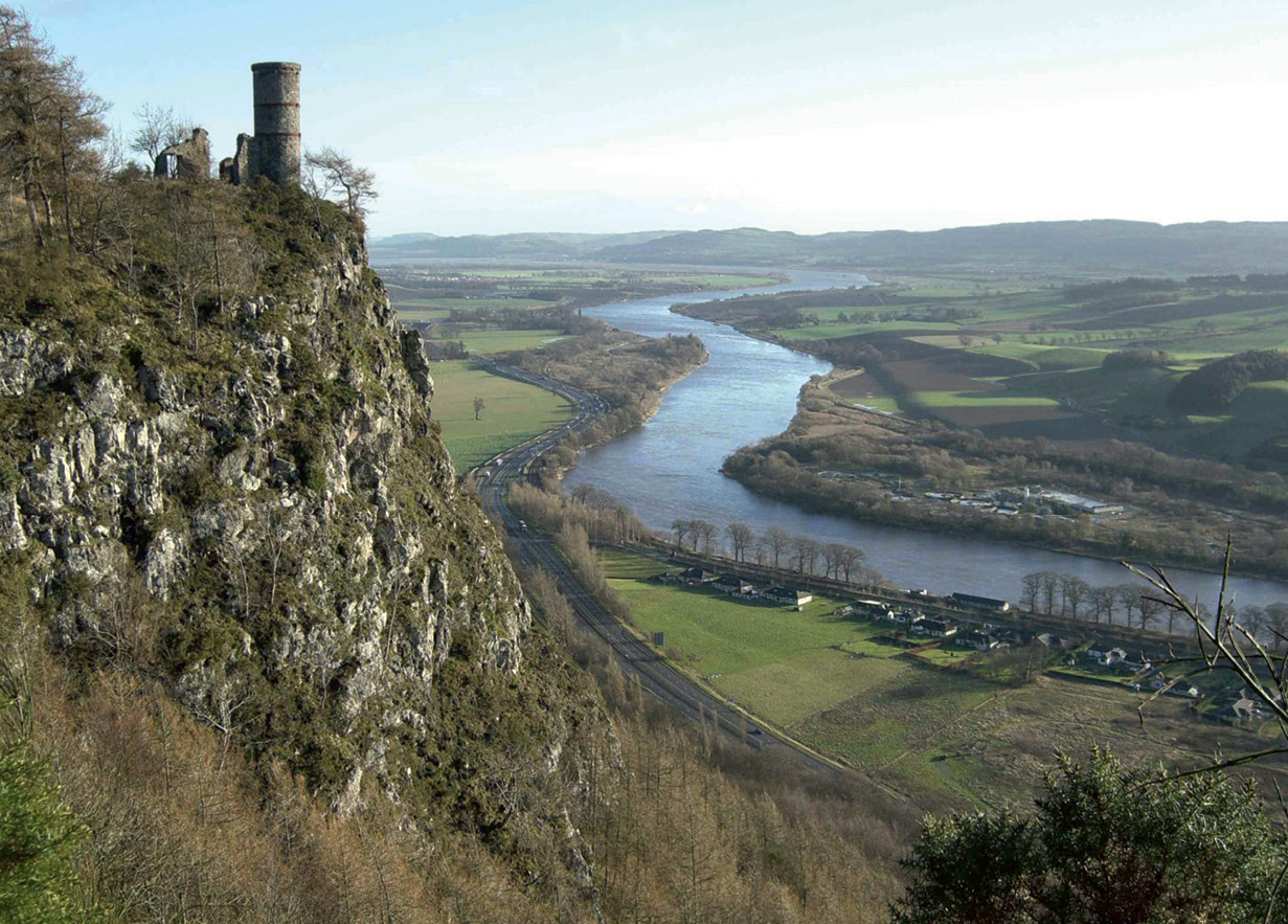
From the quarry, walk up Kinnoull Hill to the folly of Kinnoull Tower and the summit viewpoint. Follow the waymarked path to the west of the quarry uphill noting the andesitic lava knolls with large white feldspar phenocrysts (4 mm) near the picnic tables at the start. From the top of the hill and the tower
The view east from the tower has featured in many Scottish calendars. The steep wooded cliffs of Kinnoull mark the position of a significant easterly trending fault, the Kinnoull Fault that throws down to the north. A similar fault forms the south side of Moncreiffe Hill. Both these faults connect to the North Tay Fault that throws down to the south. This fault, together with the South Tay Fault, form a small rift or graben on the crest of the Ochil–Sidlaw Anticline in which the younger rocks of the Upper Devonian and Lower Carboniferous are preserved. The view west from the tower is of the Ochil Hills, with Craig Rossie near Glen Eagles (Excursion 14) a distant feature. From the nearby summit viewpoint there is also a distant view of the Highlands and also, nearer, the 'dry valley' west of Perth of the Methven Gap, where about 14,500 years ago the retreat of glacier ice west to Crieff allowed the sea to form an embayment up the Earn valley to Crieff and east down this gap to Perth. On the return descent to the quarry, a good view is obtained of the Tay valley at Scone, with views to Dunkeld.
Locality 15.3 [NO 1200 2520] Quarrymill: Scone Sandstone Formation
Quarrymill Woodland Park lies on the A93 (Perth to Blairgowrie Road), just south of Scone Palace on the east side of the River Tay opposite Perth (conveniently reached from Corsiehill Quarry). It has three waymarked walks and wheelchair accessible facilities. All start from the car park. Both the Millstone and Mill Pond routes are suitable for wheelchair users and have viewing platforms and picnic areas. The voluntarily staffed coffee shop is currently open Mon–Sat: 10am–4.30pm from the end of April to the end of September. Along the path at
The best of the rather limited geology is to be seen from the path in small cliffs beside the Annaty Burn and in the Annaty waterfall. On the west side of the wood are overgrown and landscaped quarries from which stone was thought to have been worked for Scone Abbey and Palace, the old Perth bridges and very likely the Stone of Scone (Stone of Destiny) now housed in the Regalia Room in Edinburgh Castle. The Stone appears to be made of sandstone local to Scone. A smaller scale replica of is located on Boot Hill in front of Scone Palace. Evidence provided by Fortey et al. (1998) about the Stone includes petrological descriptions of sandstone from Quarrymill, Lethendy, Huntingtower, Letham House, Crossgates and Kingoodie (Invergowrie), and is consistent with the suggestion that it came from Quarrymill.
Locality 15.4 [NO 1141 2580] River Tay at Scone Palace
From Quarrymill, turn right out of the car park and travel north, passing the main entrance to Scone Palace, then turn left on to the Stormontfield Road at Old Scone. About 400 m on, turn left
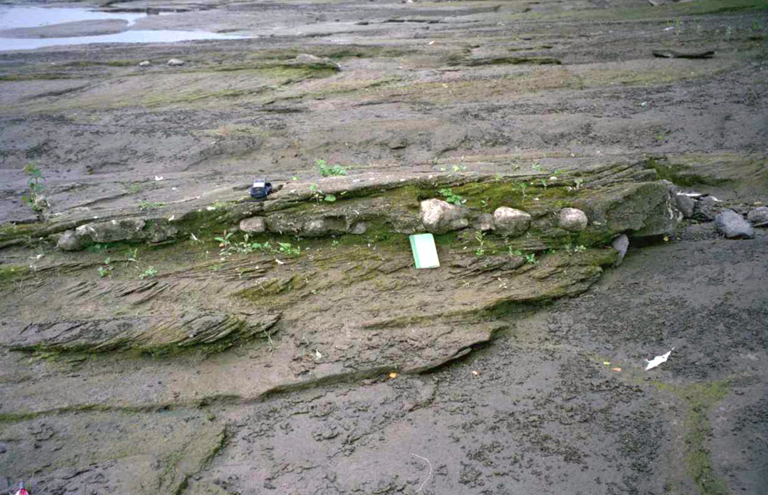
Most of this exposure is as rock reefs in the river bed. It is neither visible nor accessible when the river is in flood or even just bank full. Care needs exercising so close to this major river. This locality provides the opportunity to compare these old river deposits with the modern ones of the Tay. In this reach of the river, there is an island with one channel usually almost dry. Here the gravel bed of the river is well seen with gravel bar features in the dry channel and imbrication of the gravel is seen after floods.
The exposures, which start at
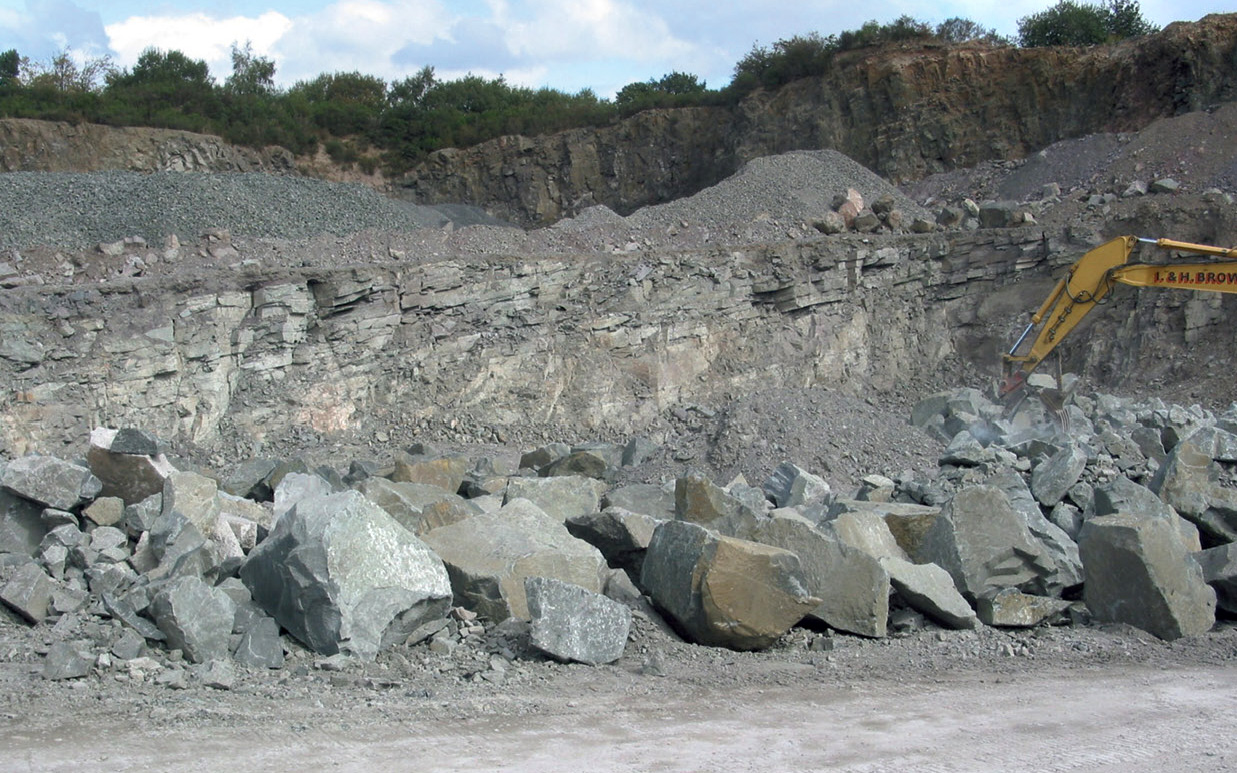
Locality 15.5 [NO 1160 2134] Friarton Quarry: Ochil Volcanic Formation , autobreccia, interbedded sedimentary rocks, quartz-dolerite dykes
From Scone Palace, return to Perth and cross the Tay to the west bank at the Victoria Bridge. Turn left (south) and then right at the Fergusson Gallery and follow the A912 from the traffic lights at the north end of the South Inch, passing Perth Prison. Turn right uphill at the end of the housing on the western side of the road in south Perth
From near the site office there is a good view of the Tay valley and the wooded scarp formed by the
The quarry exposes andesitic lava flows, up to 15–20 m thick, and interbedded sedimentary rocks consisting of siltstones, mudstones and sandstones in which lava grains are a significant component, all belonging to the
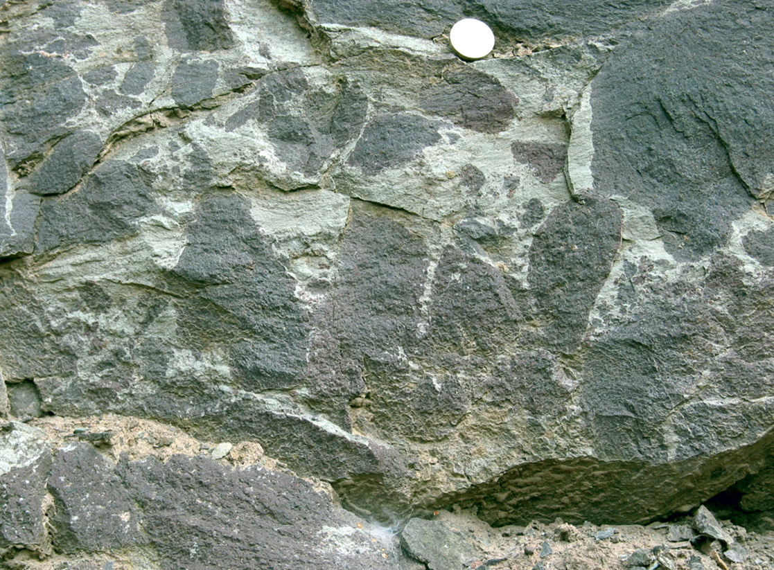
Brecciated andesitic rock is well exposed in the NE part of the site, just above the contact with sedimentary rock
Two further interpretations require that the wet sediment is laid down first and then either hot magma flows over the deposit as lava or is intruded into it as a sill. In both cases there is a violent interaction between the magma and the wet sediment producing the breccia and disrupting the bedding of the sediments by fluidisation; such breccia is known as peperite
In the southern part of the quarry, several (up to 10?)m of well-bedded, purplish and greenish grey siltstones, mudstones and sandstones may be inspected. They show flat bedding and ripple cross-bedding. Rip-up clasts are present in the coarser beds and locally small granule (grit sized) lava fragments form fine conglomerates. The bedding is inclined at about 16° to the NW, reflecting the position of the quarry, which is located on the NW limb of the Sidlaw–Ochil Anticline, a major Mid-Devonian (Acadian Orogenic event) fold structure. Careful search of the finest rocks may produce examples of trace fossils in the form of trackways of unknown arthropod animals. Red hematite-stained plant remains are present in the greenish grey siltstones. Other sedimentary features include small sand dykes, desiccation cracks and load casts. The commonly seen small faults have associated hematitic staining, e.g. in the SW corner at