Browne, M. A. E. and Gillen, C. (Eds.) 2015. A geological excursion guide to the Stirling and Perth area. Edinburgh: Edinburgh Geological Society in association with NMS Enterprises Limited. ISBN: 9781905267880. This material was published by the Edinburgh Geological Society and Geological Society of Glasgow in association with National Museums Scotland, and they have kindly made the text available for publishing on the Web. Copies of the geological excursion guides can be purchased on the EGS website: purchase excursion guides.

Geological excursion guide to the Stirling and Perth area

Edited by M. A. E. Browne and C. Gillen

Published in 2015 by Edinburgh Geological Society in association with NMS Enterprises Limited – Publishing a division of NMS Enterprises Limited National Museums Scotland Chambers Street Edinburgh EH1 1JF

Publication format, text and images © Edinburgh Geological Society 2015

No part of this publication may be reproduced, stored in a retrieval system or transmitted in any form or by any means, electronic, mechanical, photocopying, recording or otherwise, without the prior written permission of the publisher.

The rights of M. A. E. Browne and C. Gillen to be identified as the authors of this book have been asserted by them in accordance with the Copyright, Designs and Patents Act 1988.

ISBN: 978 1 905267 88 0

Publication layout and design by NMS Enterprises Limited – Publishing. Cover design: Mark Blackadder.

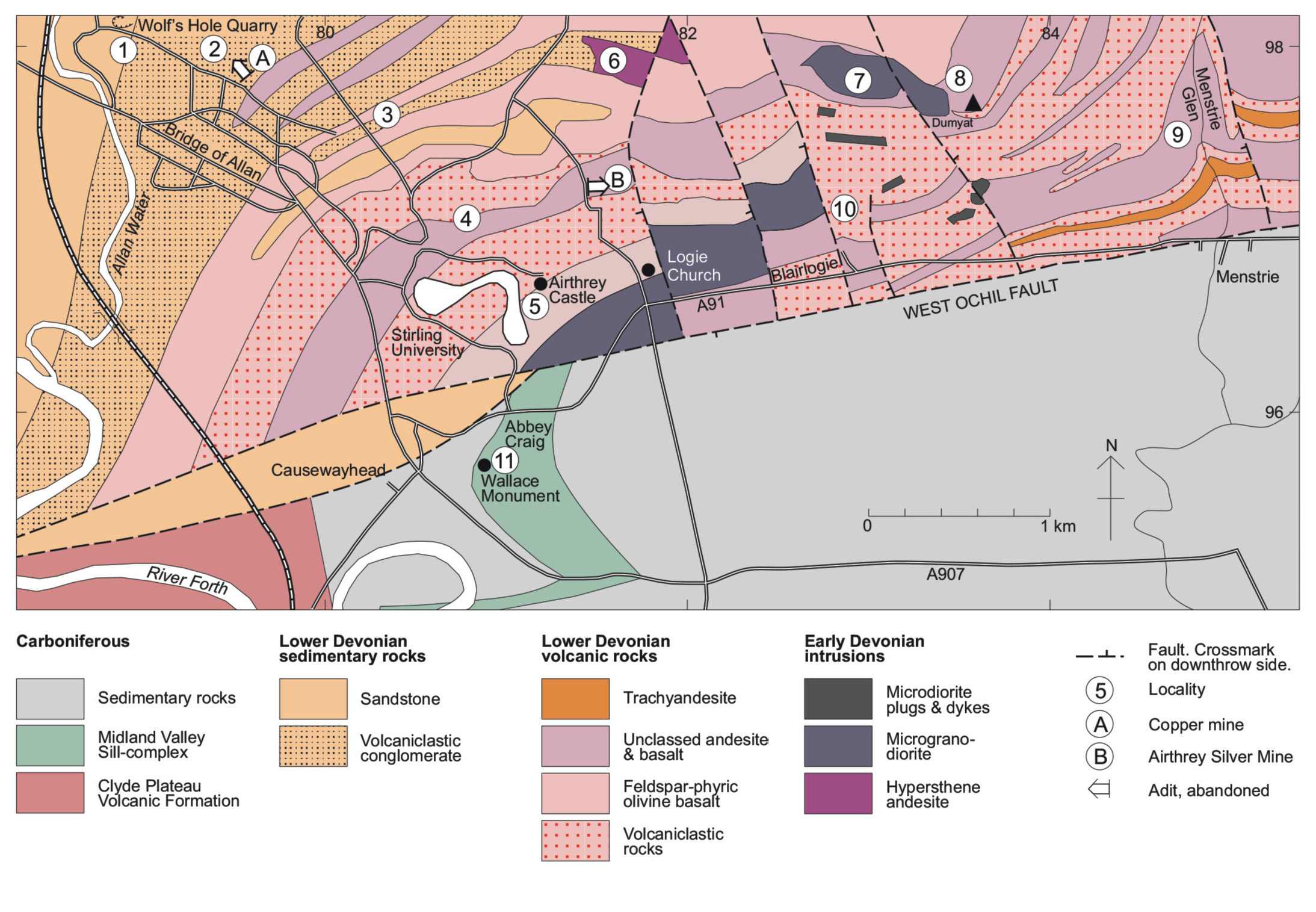
Cover image: View ENE from the Wallace Monument on Abbey Craig of the West Ochil Fault Scarp near Blairlogie. The Ochil Hills are formed by rocks of the Lower Devonian Ochil Volcanic Formation and the low ground by much softer Carboniferous-age rocks overlain by thick Quaternary deposits © M. A. E. Browne.

Printed and bound in Spain by Novoprint, SA, Barcelona.

For a full listing of titles and related merchandise, please contact: www.nms.ac.uk/books www.edinburghgeolsoc.org

Image credits

Every attempt has been made to contact copyright holders. If any images have been inadvertently missed, please contact the publisher

(Figure S.1), (Figure 2.1), (Figure 2.2), (Figure 3.1), (Figure 3.2), (Figure 3.3), (Figure 4.1), (Figure 4.2), (Figure 5.1), (Figure 6.1), (Figure 6.2), (Figure 7.1), (Figure 8.1), (Figure 8.2), (Figure 9.1), (Figure 13.1), (Figure 14.1), (Figure 15.1) and (Figure 17.1) are derived in part from data reproduced by permission of the British Geological Survey © NERC. All rights reserved. CP15/025. Ordnance Survey map data reproduced with permission of Ordnance Survey. Licence number 100033582.

Photographs © M. A. E. Browne and C. Gillen.

Contributors

Matt Armstrong (deceased, formerly BGS)

Mike Browne BGS, Edinburgh

Peter Craig Tarland by Alford, Aberdeenshire (formerly BGS)

Doug Fettes Edinburgh (formerly BGS)

Rhoda Fothergill Perth

Howell Francis (deceased, formerly BGS and Leeds University)

Rosalind Garton St Andrews University

Con Gillen Edinburgh University

Ian Hall Edinburgh (formerly BGS)

Tony Harris

Cardiff University (formerly BGS and Liverpool University)

Donald MacIntyre (deceased, formerly Pomona College, USA)

Andrew McMillan Edinburgh (formerly BGS)

Jon Merritt BGS, Edinburgh

Bill Read (deceased, formerly BGS)

Philip Rose Aberdeen (formerly Liverpool University)

Jack Soper Threshfield, Skipton (formerly Sheffield University)

Acknowledgements

All the maps have been drafted by Angus Miller of Geowalks (Edinburgh). All photographs are by the editors. We wish to thank those geologists who kindly undertook to review individual excursions. The Edinburgh Geological Society made a grant available for the drawing of the excursion maps.

David Stephenson and Kathryn Goodenough are thanked for their editorial contributions. We would like to express particular thanks to David Stephenson for his meticulous editing.

Editorial introduction

This field guide has had a long history since the idea was mooted in the 1970s, and many of the excursions had been drafted by the end of the 1980s. We have taken the opportunity when editing the text and revisiting all the exposures to remove out-of-date references and add the most-recent research results and concepts. Some localities had degraded to the extent that we could not justify retaining them in the guide. In addition, we were obliged to remove some excursions entirely, as a result of restrictions on the overall size of the book. All national grid references are based on GPS readings taken at the time of our visits.

Since this is a field guide, readers wishing to have overviews of the geology and landscapes are referred to the following works: Cameron & Stephenson (1985), Browne & Mendum (1995), Trewin (2002), McKirdy et al. (2009), Friend (2012), Gillen (2013). The Stirling Memoir (Francis et al., 1970) and the Perth Memoir (Armstrong et al., 1985) are key references for most of the more detailed geology and are referred to separately only in chapters where there is a specific reason.

Contents

Summary of geology

Excursion 1: Stirling: building stones

Excursion 2: Bannock Burn

Excursion 3: Falkirk

Excursion 4: Muiravonside Country Park

Excursion 5: Bridge of Allan and Dumyat

Excursion 6: Silver Glen, Alva

Excursion 7: Mill Glen, Tillicoultry

Excursion 8: Teith valley and Strathallan

Excursion 9: Gargunnock Burn

Excursion 10: Fintry

Excursion 11: Kilsyth and Denny

Excursion 12: Braeleny, Keltie Water

Excursion 13: Bracklinn Falls, Keltie Water

Excursion 14: Craig Rossie

Excursion 15: Perth

Excursion 16: Perth: building stones

Excursion 17: Stanley and Campsie Linn

Excursion 18: Dunkeld and Little Glen Shee

Figures and plates

References

(Figure 2.1) Map of late Viséan rocks exposed in the upper Bannock Burn near Todholes, showing localities for Excursion 2. Adapted from Francis et al. (1970, fig. 13).

(Figure 2.2) Vertical sections of late Viséan rocks exposed in the Bannock Burn, (A) near Todholes and (B) near Touchadam Quarry. Adapted from Francis et al. (1970, fig. 15).

(Figure 3.1) Geological map of Falkirk area, showing Localities 1–3 for Excursion 3.

(Figure 3.2) Vertical section of Scottish Lower Coal Measures Formation in the Falkirk area.

(Figure 3.3) Geological map of Skinflats area, Locality 3.4.

(Figure 4.1) Geological map of the area around Muiravonside Country Park, showing localities for Excursion 4.

(Figure 4.2) Vertical section of the Passage and Upper Limestone formations in the Muiravonside area.

(Figure 5.1) Geological bedrock map of the Bridge of Allan–Menstrie area, showing localities for Excursion 5.

(Figure 6.1) Geological map of the Silver Glen, Alva, showing localities for Excursion 6. Adapted from Hall, Gallagher et al. (1982, fig. 4a).

(Figure 6.2) Vertical section of mineral features in the Silver Glen. Adapted from Hall, Gallagher et al. (1982, fig. 4b).

(Figure 7.1) Geological map of the area around the Mill Glen, Tillicoultry, showing localities for Excursion 7.

(Figure 8.1) Quaternary geological map and cross-section of the Teith valley south of Callander.

(Figure 8.2) Route map and generalised Quaternary geological map of the Teith valley and Strathallan, showing localities for Excursion 8.

(Figure 9.1) Geological map of the area around the Gargunnock Burn, showing localities for Excursion 9.

(Figure 13.1) Geological map of the area around the Keltie Water between Eas na Caillich and Bracklinn Falls, Callander, showing localities for Excursion 13. Adapted from Francis et al. (1970, fig. 9).

(Figure 14.1) Geological map of the area around Craig Rossie, showing localities for Excursion 14.

(Figure 15.1) Geological map of the area around Perth, showing localities for Excursion 15. Adapted from Fortey et al. (1998, fig. 4).

(Figure 17.1) Geological map of the area around the River Tay at Stanley, showing localities for Excursion 17.

(Figure S.1) Outline geological map of the region covered by this excursion guide.