Chapter 2 Southern Uplands
Introduction — A structural perspective
J.E. Treagus
The stratigraphical framework
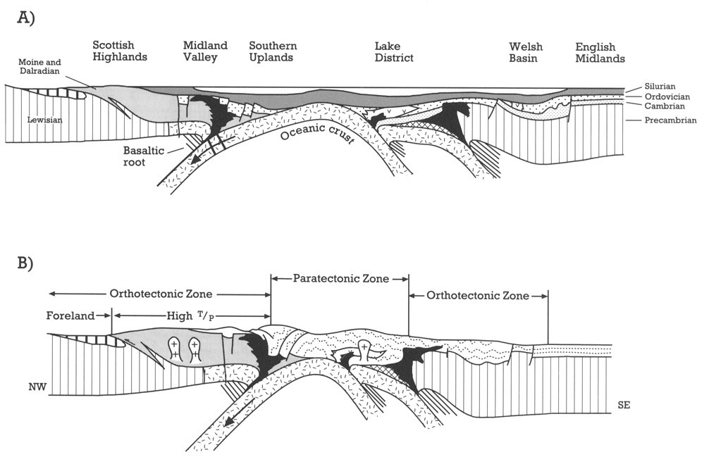
For almost a hundred years, after the first researches of Lapworth (1874, 1889) and the work of the Geological Survey of Scotland (Peach and Horne, 1899), there was a curious lack of interest in the structure of the Southern Uplands. Today, the area is celebrated internationally for its structures, which are perhaps the most quoted examples of folds, cleavage, and faults developed in an ancient accretionary prism. In the early Palaeozoic, that prism lay just to the north of the presumed Iapetus suture.
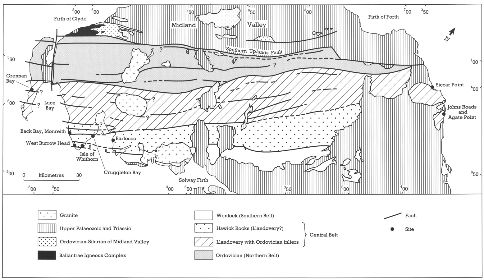
The gross stratigraphical framework of the rocks is largely that established by Peach and Horne (1899), and is shown in
The early workers clearly recognized the intensity of both folding and cleavage, although little use was made of minor structural geometry to define the major structures. Hall (1815), one of the first to realize the significance of folded strata in terms of the stresses imposed, was principally inspired by observations on the rocks of the Berwickshire coast. He carried out some of the first model experiments in an attempt to reproduce these folds.
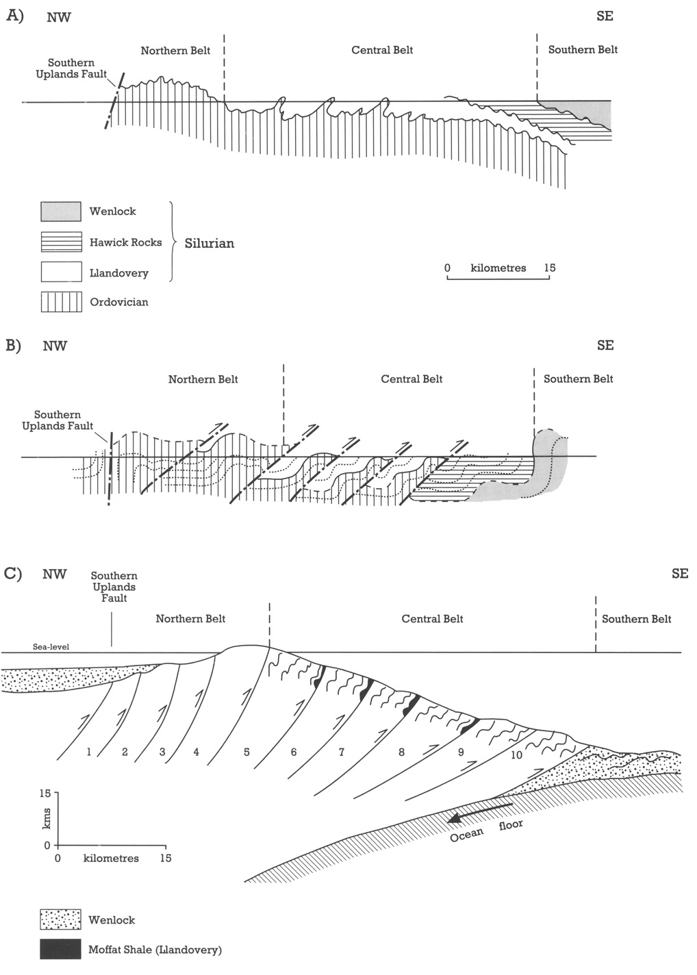
The first structural cross-sections of the Southern Uplands (Lapworth, 1889; Peach and Horne, 1899) depicted the Ordovician rocks of the north as essentially the core of a broad anticline
Structural observations
The 1960s saw the first important stage of structural reassessment. An examination of the sedimentary structures in the greywackes led Craig and Walton (1959) to realize that minor and major fold vergences were to the south-east, which, combined with the NW-younging of the long limbs of the folds, meant that the previous structural interpretation had to be erroneous. However, an interpretation was required that would reconcile these observations with the irrefutable fact that older rocks were encountered in successive belts from south-east to north-west. Walton (1961; see
Further work in the 1960s by Rust (1965), Walton (1965), and Weir (1968) was cgricemed with more detailed description of the minor structures in the Silurian rocks of the Central Belt
The only description of detailed structure in the Ordovician of the Northern Belt is that of Kelling (1961). Although some of the more elaborate structural histories have now been simplified (Weir, 1979; Stringer and Treagus, 1980, 1981), this work recognized two important structural features: firstly, the presence of steeply plunging and curvilinear hinges and, secondly, the presence of a superimposed local deformation, producing cleavage and axial surfaces with flat to moderate dips to the south-east.
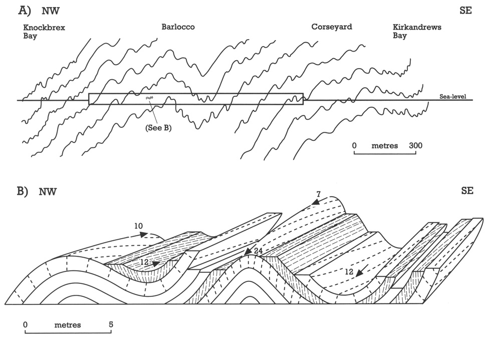
Stringer and Treagus (1980, 1981) interpreted the deformation history of the Southern Uplands in terms, essentially, of a single deformation phase (D1) with local modification by D2. From observations principally in the Hawick Rocks, in the Wigtown Bay area, they described D1 folds as generally tight and upright with first-order folds having amplitudes of about 300–500 m and spacing of 0.25–3.0 km. The folds of this scale are asymmetrical with vergence to the south-east, but intermediate folds, seen on a scale of one hundred metres or less, locally verge to the north-west in narrow belts on the short limbs of the major folds (see
A major feature of interest to structural geologists was the observation by Stringer and Treagus (1981) that the cleavage (S1) related to the first deformation was not parallel to the axial surfaces of individual folds. This feature is now widely recognized elsewhere in the Caledonides, and is referred to as 'fold transection by cleavage'. It is manifested, in the Southern Uplands, by an approximate 10° difference in the strike of cleavage, clockwise with respect to that of the axial surfaces. Parallelism, as well as occasional anticlockwise transection, was also observed. Stringer and Treagus demonstrated that, although the customary divergent (in mudstone) and convergent (in sandstone) cleavage fans were developed around the folds, the transection resulted in intersection lineations, between bedding and cleavage, in both materials which were dispersed, as shown in
The D2 deformation, as defined by Stringer and Treagus (1980), is exposed as open to tight folds with wavelengths from tens of centimetres to tens of metres, associated with a flat, south-easterly dipping, crenulation cleavage. These folds affect steep-dipping D1 fold limbs resulting in generally subhorizontal plunge and neutral vergence. These folds are strongly developed in a 2–3 km-wide belt in the northern part of the Hawick Rocks across the Wigtown Peninsula.
The accretionary prism model
Dewey's (1969) paper on the evolution of the Caledonides
Detailed structural observations on the thrusts themselves have been sparse, partly owing to their poor exposure. Until recently (for example, Rust, 1965; Toghill, 1970; Fyfe and Weir, 1976; Cook and Weir, 1979), work has concentrated on thrust geometry and stratigraphical separation, and observations on shear-sense or timing, with respect to D1, have been rare. Webb (1983) considered that thrusts in the Ettrick imbricate structure resulted from south-easterly-directed extension of rotated short limbs of the D1 folds, but that they pre-dated the S1 cleavage.
Stringer and Treagus (1981) and Treagus and Treagus (1981) have attempted to relate the non-axial plane cleavage in the Southern Uplands to this plate tectonic setting. They pointed out that a non-orthogonal relationship between the initial folds in the sedimentary pile and the subsequent stresses, caused by oblique ocean closure, would result in the observed transection of folds by cleavage. Other workers (for instance, Sanderson et al., 1980) have interpreted the phenomena in terms of transpression, essentially a combination of pure shear perpendicular to the sedimentary strike and simple shear (sinistral) parallel to that strike, as a consequence of oblique convergence of the margins of the Iapetus. Such a model predicts horizontal stretching near the ocean suture and down-dip stretching away from the suture. Such strain variations are recorded in the Irish Caledonides, but in the Scottish Southern Uplands, Stringer and Treagus (1981) record only very weak down-dip extension in the flattening strain associated with cleavage. Thus the obliquity between cleavage and the axial planes of folds is particularly important evidence for the model of the Southern Uplands as a part of an ancient accretionary prism. More precise strain measurement will help in the clarification of the model.
Several workers have identified isoclinal folds which appear to be pre-D1 folding, particularly in the Hawick Rocks. Rust (1965) was the first to appreciate the presence of such large-scale isoclinal folds and their presence has been confirmed in several of the present site investigations. Such folds, as well as disrupted units and other slump structures, are identified by Knipe and Needham (1986) as an essential part of the early evolution of accretionary complexes.
Recent work
There has been a spate of work in the Southern Uplands since 1986, much of it stratigraphical and sedimentological, which has resulted in variations on and repudiation of the accretionary prism model. Some papers (see below) provide important new structural data, which undoubtedly will be used in future site selection. Barnes et al. (1987), for example, report new work in the Rhinns of Galloway (McCurry) and on the Wigtown Peninsula (Barnes), in previously undescribed rocks of the Central Belt. Unusual aspects of this work are the description of a substantial belt of north-verging D1 folds in SE-younging rocks, with northward downthrow on steep faults on the Rhinns. Thrusting, both north and south down-throwing, is syn-D1, as are the steeply plunging folds, except where rotated locally by post-D2 deformation. Kemp and White (1985) and Kemp (1987) have detailed, for the first time, some Southern Belt rocks of Wenlock age. Apart from new palaeontological and sedimentological data, which reveal the highly imbricated nature of the northern part of this belt, he discusses the nature of the 'sheared zones' which characterize the rocks: the bedding is imbricated and disrupted, and they are affected by SE-verging folds, faulting, and boudinage. The origin of these zones appears to be partly soft-sediment deformation, but essentially they formed during D1, partly post-dating S. Common, sinistral, steep-plunging folds post-date D1.
The attack on the interpretation of the Southern Uplands as a forearc accretionary prism especially by Hutton and Murphy (1987), Morris (1987), and Stone et al. (1987) is mentioned above. The detailed scrutiny of greywacke provenance and palaeocurrents has shown that there was a significant Ordovician input of sediment from the south, much of it derived from a missing volcanic arc, that is an arc destroyed through subduction or
strike-slip faulting (see below). These and other, essentially sedimentological, arguments are certainly going to produce a reassessment of the structural evolution of the Southern Uplands in future years.
The variations in the accretionary prism model, for instance the role of imbricate thrusting and the timing of collision (Hutton and Murphy, 1987; Stone et al., 1987), may eventually be resolved by the detailed examination of the structures such as the geometry of the D1 folds, the timing of the transecting S1 cleavage, the strain variation, particularly towards and within the thrust zones, the significance of the plunge variation, and especially the relationship between thrusting and faulting and other deformation events. Of particular interest will be a comparison of the structural history and style of the Northern Belt with that of the Silurian rocks. Hutton and Murphy (1987) report cleaved Middle Ordovician (gracilis biozone) shales as clasts in the Silurian, and Morris (1987) describes an earlier deformation history in the Ordovician of the Longford Down Inlier in Ireland.
As yet, the most significant structural contribution to the new models has come from Anderson and Oliver (1986), in a reinterpretation of the displacement on the Irish Orlock Bridge Fault. The apparent equivalent of this fault in Scotland, the Kingledores Fault, separates the Ordovician of the Northern Belt of the Southern Uplands from the essentially Silurian rocks of the Central Belt
Another of these terrane boundaries would be the Southern Uplands Fault, the northern boundary of the rocks treated in this volume. Traditionally, it is seen as a steep fracture (with major splays into the Glen App, Stinchar Valley, and Lammermuir Faults). It is assumed to have a downthrow to the north-west, based on the contrast of Lower Palaeozoic facies on its two sides and on the truncation of the Lower Devonian on its northern side. In the accretionary prism models, the fault is usually shown as a successor to one of the powerful, steep, NW-downthrowing thrusts, but Bluck (1986) also suggests that it is the site of NW-thrusting which has caused the juxtaposition of the trench sediments of the Southern Uplands against the proximal forearc deposits of the Girvan area to the north. Again, from consideration of sources of Lower Palaeozoic sediments north and south of the fault, Hutton (1987) argues for substantial strike-slip motion in the Late Silurian. Exposures of the fault zone are highly brecciated, fractured and veined, but there are no reports of any local criteria which can be used to prove the Caledonian displacement sense.
Faults
Minor faults of post-D1 age, which are probably Caledonian in age, abound in the Southern Uplands. Many workers report brecciation and other symptoms of brittle deformation coincident with the major strike-parallel thrust faults, as well as those at high angles to the strike. The N–S wrench faults, with sinistral displacement, are particularly widely reported. Dextral wrench faults with a more north-east trend are also reported (Weir, 1979). Other post-cleavage faults and fractures, showing a wide range in orientation, can be seen in most of the sites described; many clearly have a displacement, but the absence of markers makes a unique calculation of displacement sense, or amount, difficult. Low-angle faults, with both north-west and south-east dips, with both thrust and normal displacement, and throws apparently in the order of a few centimetres, can be deciphered in most shore sections. No overall stress vector pattern has been proposed.
Timing of deformation
The precise timing of the various stages of the Caledonian deformation in the Southern Uplands is not always clear. In particular, there are dates for neither the development of the D1 folding, which might be expected to be diachronous across the fold belt, nor for the cleavage development. However, D1 folds and S1 cleavage affect rocks of at least the C. lundgreni biozone of the Wenlock Series. Dykes which post-date S1 and largely pre-date D2 folds (Stringer and Treagus, 1980) have been dated (Rock et al., 1986) between 418 and 395 Ma. These dykes are mostly cut by the Devonian granites which have dates ranging from 408 to 392 Ma. The writer's observations on contact porphyroblasts suggest that the Cairnsmore of Fleet Granite (392 ± 2 Ma) pre-dates, or is closely associated with, D2: this relationship is very similar to the relationship seen between the granites and folds (D2) in the Lake District. Lower Devonian lavas (Upper Gedinnian) unconformably overlie folded Silurian at St Abb's Head as well as in the Cheviots, where the lavas are cut by the Cheviot Granite dated at 391 Ma. Although these lavas are often quoted (Powell and Phillips, 1985) as Upper Gedinnian in age, McKerrow (1988) points out that both the faunal evidence and the latest radiometric dates (389–383 Ma; Thirlwall, 1988) would allow a Late Emsian age (perhaps about 397–390 Ma) for the main deformation event. Such a date would correlate well with that deduced for the Lake District and Wales (Soper et al. , 1987; Soper, 1988; McKerrow, 1988) and with part of the Acadian Orogeny of Canada.
The selected sites are shown in
All the sites (except for Burrow Head) also show the characteristic NW-younging on the long limbs of the SE-verging D1 folds, as well as transection of the folds by the S1 cleavage. One site (Back Bay, Monreith) illustrates the style of the deformation, and two (Burrow Head and Grennan Bay) illustrate the nature of the faulted junctions. No suitable site was found to illustrate the later faulting, including the Southern Uplands Fault and parallel fractures.