Chapter 2 Geological framework
The regional setting — Variscan Orogen
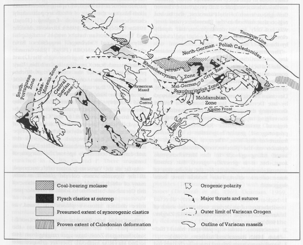
A large part of the geology of Europe from Poland to Iberia is represented by the broad, sinuous, roughly E–W-trending Variscan fold belt which has affinities with the Appalachian Belt on the other side of the Atlantic Ocean and the Uralide Belt in Russia. This section provides a very generalized (and over-simplified) picture of the European Variscides within which to locate the particular magmatic rocks from south-west England which form the substance of this volume. Detailed reviews of the tectonic framework and development of the Variscan fold belt and its different segments may be found in Krebs (1977), Zwart and Dornsiepen (1978), Franke and Engel (1982), Behr et al. (1984), Lorenz and Nicholls (1984), Matte (1986), Ziegler (1986) and Franke (1989). The following outline largely follows Franke (1989).
The Variscan Orogen of northern Europe consists of a series of Ordovician to Carboniferous rift-generated basins, separated by metamorphosed crystalline ridges, which were progressively closed by the northward migration and subsequent collision of African Gondwanaland with northern Baltica. Early work by Kossmat (1927) subdivided the Variscan orogenic belt into a number of tectonic zones separated by major thrusts, ranging from the northern (external) Rhenoher-cynian zone to the (internal) Saxothuringian and Moldanubian zones of central Europe
Essential to the Variscan story is the staged closure of the sedimentary basins by subduction of narrow oceanic segments and northwards-directed thrusting from late Ordovician through to the Carboniferous, such that many sequences are thrust bound and parautochthonous or allochthonous in character. In contrast to the general northwards convergence and progressive closure throughout much of the Palaeozoic, the basinal region that formed in the Rhenohercynian zone was not only late in development, but rapidly closed – opening in early Devonian and closing by the end of the late Devonian.
The magmatic rocks described in this volume are all within the external Rhenohercynian Zone of the Variscides, some of which have features in common with their counterparts in the rest of the orogen. The sedimentary and volcanic record of the Rhenohercynian Zone reflects an early Devonian rifting event that was rapidly followed by late Devonian to late Carboniferous crustal shortening that produced stacks of northwards-converging nappes and accompanying low-grade regional metamorphism. Relatively high-level, post-orogenic, granite magmatism is a common feature of this zone. There is a difference of opinion on the plate-tectonic situation of the initial rifting episode in the Rhenohercynian zone, but it is generally agreed that crustal attenuation was sufficient for the production of some oceanic crust. Four models have been suggested:
- back-arc basin related to northerly directed subduction of an oceanic area to the south of Armorica (Floyd, 1982b; Leeder, 1982; Ziegler, 1986);
- intracratonic strike-slip pull-apart basin (Bad-ham, 1982; Barnes and Andrews, 1986);
- small ocean basin related to southerly directed and although the older intrusions originated by subduction under an active arc to the north of Armorica (Holder and Leveridge, 1986);
- small ocean basin generated as continental crust overrode a relict Caledonian spreading axis (Matthews, 1978; Franke, 1989).
Basic–acidic volcanism is a characteristic of all Variscan tectonic zones, although volcanic sequences are generally dominated by basalts ('spilites') with minor trachytes and rhyolites ('keratophyres' and 'quartz keratophyres'). Early Devonian rhyolites and late Devonian–Dinantian basalt pillow lavas and intrusives in south-west England have their temporal counterparts throughout the Rhenohercynian and Saxothuring-ian Zones, although the Moldanubian zone also exhibits late Dinantian calc-alkaline andesite-dominated volcanism. Throughout the Rhenohercynian zone most of the basalts are incompatible element-enriched, intraplate tholeiites and alkali basalts – the latter of which are particularly characteristic of south-west England (Floyd, 1982a; Wedepohl et at, 1983). However, Middle and Upper Devonian basalts within stratigraphically restricted mélange sequences have chemical affinities to MORB (Floyd, 1984; Grosser and Dorr, 1986) and, together with the Lizard ophiolite and
As far as the Variscan granites are concerned, all the tectonic zones contain granitic massifs, many of which include types resembling those of the Cornubian batholith. In addition to older pre-Variscan intrusives and metamorphics, two or three distinct intrusive phases are found, as illustrated below.
The Kruŝné hory Mountains granitoids (northwest part of the Bohemian Massif) in the Saxothuringian Zone, have ages ranging from 340 to 260 Ma (K/Ar method). They are grouped into an Older Intrusive Complex, with biotite and I-type granite characteristics, and a Younger Intrusive Complex, with Li-mica and the chemical attributes of S-type granites. The youngest rocks also have high concentrations of Rb (c 500 ppm), Sn (c. 38 ppm) and F (c. 2900 ppm) (temprok, 1986). The granites of Normandy and northern Brittany group into suites with ages ranging from 340–300 Ma and 300–280 Ma (both K/Ar and Rb/Sr methods). Where these have been characterized as 'S' or 'I' types, the latter tend to be the older, and the younger group tends to be relatively enriched in Sn and other metals (Chauris et al., 1969; Adams, 1976; Peucat et al., 1984; Georget et al., 1986).
In the Schwarzwald, granites (dated by the Rb/Sr method) form three series ranging from about 363 Ma through 330–310 Ma (the majority) to 290–280 Ma. They lie in the Moldanubian zone and although the older intrusions originated by crustal melting, the younger show evidence of fractional crystallization and magmatic differentiation, together with high-level intrusive characteristics. With decreasing age, overall Sr contents fall (245 to ?24 ppm), whereas both Rb and F rise (228 to 483 ppm Rb and 618 to 1575 ppm F) (Emmerman, 1977). Also in the Moldanubian zone are the granitoids of southern Brittany and the Massif Central and here, too, there are 'older' and 'younger' generations dated at about 310–300 Ma and 290–280 Ma (K/Ar and Rb/Sr methods) (de Albuquerque, 1971; Reavy, 1989). In both cases there is evidence of differentiation sequences, but whereas de Albuquerque (1971) supposes that the parent rocks were pelites and greywackes, Pinto (1983) suggests that the younger granites have I-type characteristics.
Throughout the Variscides of northern Europe, therefore, granites of approximately the same age as those in Cornubia are found and they often display similar chemical characters, such as being enriched in Li, Rb, Sn and F. There are two important differences, however. On the continental mainland, they lie overwhelmingly within the Saxothuringian and Moldanubian tectonic zones, whereas the Cornubian rocks are in the Rhenohercynian zone where rather few granitoids (for example, Harz Massif) occur relative to the mainland. Secondly, in Cornubia, only the younger (300–280 Ma) suite is found, the older generations apparently being absent. These features tend to support the suggestion, discussed elsewhere in this volume, that the Cornubian batho-lith may be detached from its original roots.
The local setting – Rhenohercynian zone of south-west England
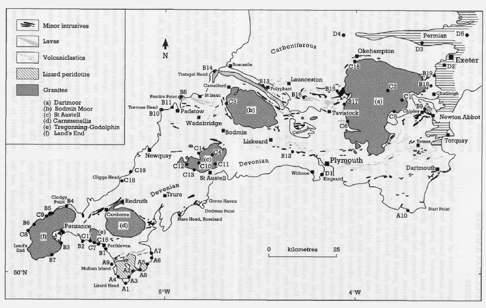
We now turn to south-west England, which is representative of the western end of the external Rhenohercynian zone. This section provides a simplified geological framework for the volcanic and plutonic events outlined in Chapter 1, and from which the sites have been chosen. Recent work and summaries of the geology of south-west England may be found in Durrance and Laming (1982), Hancock (1983), Hutton and Sanderson (1984) and Dineley (1986). An outline geology of south-west England and the distribution of magmatic rocks is shown in
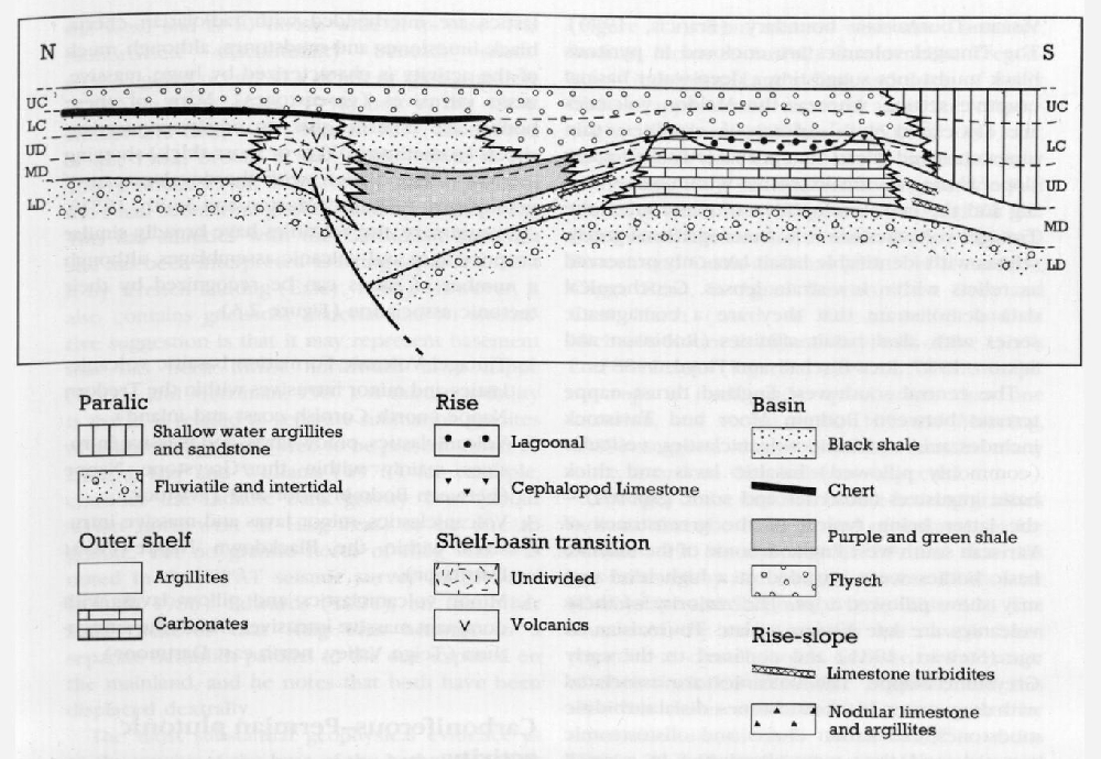
Throughout the Devonian and Carboniferous periods, south-west England was mainly characterized by the successive northward development and subsequent closure of small, often deep-water, basins (Matthews, 1977). They were bordered to the north by shallow coastal shelves and initially received debris from the Old Red Sandstone continent in South Wales and the Bristol Channel (Freshney et al., 1972, 1979; Tunbridge, 1986). Later, a southern source was also important, with flysch and sedimentary mélange material derived from northwards-advancing nappes filling both late Devonian and Carboniferous basins (Isaac et al., 1982; Holder and Leveridge, 1986). During mid-Devonian times, basins in the east were segmented by 'rises' that developed shallow-water carbonate banks possibly capping volcanic seamounts (Edmonds et al., 1969).
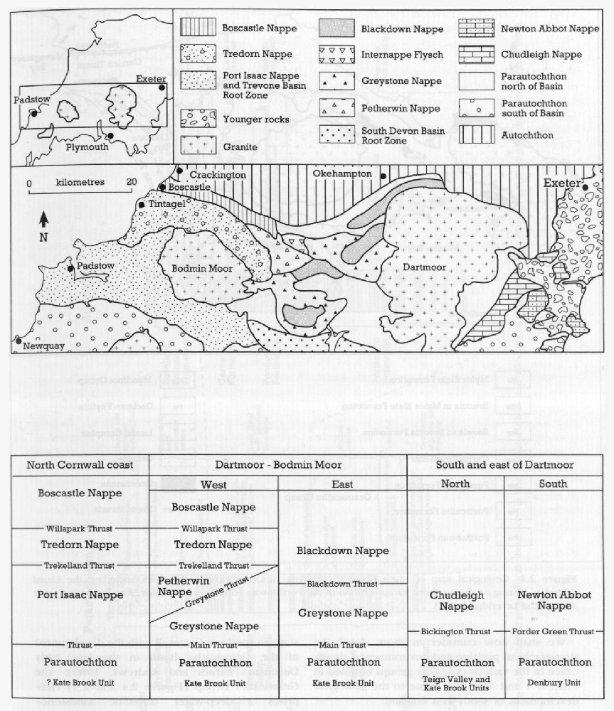
Structurally, the Variscan fold belt is dominated by thrust ('thin-skin') tectonics with piles of southerly derived nappes characterizing Cornwall and central south-west England (for example, Matthews, 1981; Isaac et al., 1982; Shackleton et al., 1982; Leveridge et al., 1984; Selwood and Thomas, 1986a and 1986b).
Volcanic sequences occur at various structural levels within the nappes such that Upper Devonian lavas can be found overlying Lower Carboniferous volcanics of similar eruptive character. For example, detailed structural schemes for central south-west England have been recorded by Isaac et al. (1982), Selwood et al. (1985) and Selwood and Thomas (1986a, 1986b), and these emphasize the presence of various nappes thrust over parautochthonous/autochthonous 'basement'.
We shall now consider in more detail the stratigraphical position and environmental significance of the various magmatic groups outlined in Chapter 1 and how they relate to the geological development of south-west England.
Devonian volcanic activity
Lizard and west Cornwall region
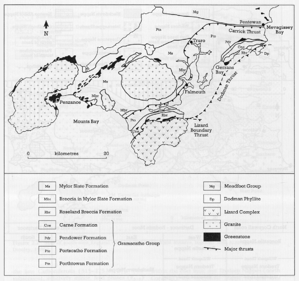
The most significant part of the magmatic story starts in southern Cornwall with the development of the Gramscatho Basin in the late, early Devonian (Barnes and Andrews, 1986). The
- a northern parautochthonous region which is separated by the Carrick Thrust (Leveridge et al., 1984) from
- an allochthon composed of a series of thrust slices which includes the
Lizard Complex at the highest structural level.
The
The importance of the magmatic rocks in this region
- Lizard ophiolite (Strong et al., 1975; Bromley, 1976, 1979; Styles and Kirby, 1980; Kirby, 1979a, 1979b, 1984) and associated hornblende schists.
- Metabasic clasts within the south Cornish mélange zone (Barnes, 1983) – the
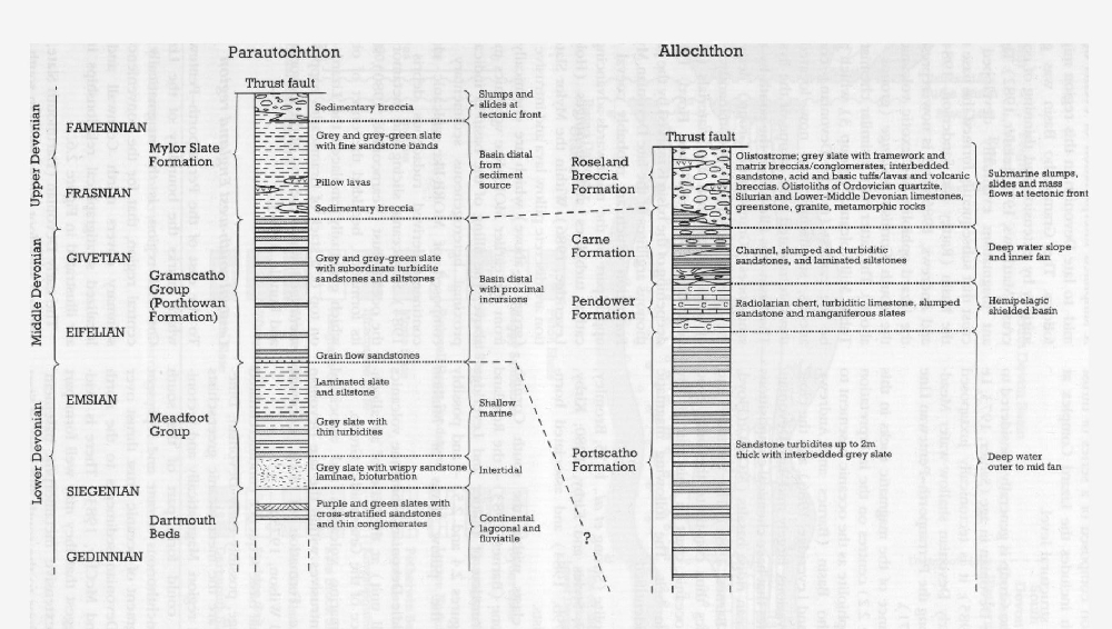
Roseland Breccia Formation of Holder and Leveridge (1986) ((Figure 2.4) and(Figure 2.5) – and possibly including the pillow lavas of Mullion Island. - In situ Middle Devonian submarine volcanics (Tubbs Mill unit) at the base of an allochthonous slice of the
Gramscatho Group . - Basic, submarine volcanics and associated high-level intrusives within the late Devonian
Mylor Slate Formation of west Cornwall (Taylor and Wilson, 1975). - An additional basic sequence (undifferentiated Devonian age, possibly early Devonian; Dine-ley, 1986) are the metavolcanic greenschists of the Start region. Magmatically and tectonically, they could form part of the south Cornish allochthonous terrane and represent another segment of oceanic crust thrust over the early Devonian sediments to the north (Coward and McClay, 1983). There is evidence to suggest that they may well form part of a more extensive 'metamorphic basement' to the sea floor to the south and west of Start Point (Phillips, 1964).
A simplified interpretation of events during the mid- to late Devonian in this region might be as follows. The Gramscatho Basin was generated initially by extension and thinning of continental crust (Matthews, 1977; Leeder, 1982). The attendant magmatism eventually developed oceanic crust that subsequently formed the base to part of the basin (Rattey and Sanderson, 1984; Barnes and Andrews, 1986) and is now represented by the Lizard ophiolite and exotic volcanics within the south Cornish mélange (groups 1 and 2 above). The latter have a similar chemistry to the Tubbs Mill volcanics (group 3), which appear to be the earliest (middle Devonian), contemporaneous, submarine lavas now located at the thrust-terminated base of one of the flysch units. The basin was filled from the south by turbiditic sandstones (
Central south-west England region
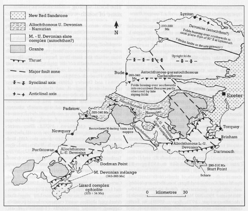
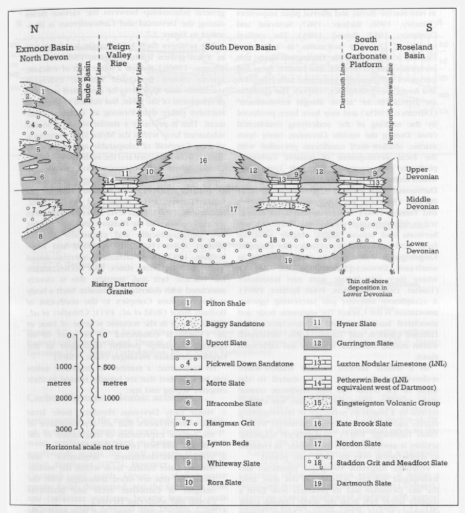
To the east of the Perranporth–Pentewan Line, which marks the boundary of the Lizard/west Cornwall region, is the magmatically distinct central region, that for the convenience of this summary covers north Cornwall and Devon. Idealized stratigraphical relationships in Devon are illustrated in
The early Devonian (Dartmouth Slate, Staddon Grit and Meadfoot Formations) in south Devon is characterized by shallow-water tidal facies as well as non-marine fluvial and alluvial plain sequences ( Dineley, 1966; Richter, 1967; Selwood and Durrance, 1982; Pound, 1983). The earliest record of Devonian volcanism in south-west England is seen within the Dartmouth Slates; this comprises limited rhyolitic and basaltic lavas and intrusives with spatially associated tuffs (Shannon and Annis, 1933; Durrance, 1985a). The rhyolites are typical of an 'active margin environment' (Durrance, 1985a) and may have been produced by the melting of the underlying continental crust. During the middle Devonian, more open marine, shallow-shelf conditions prevailed with the local development of massive carbonate platforms (for example, Plymouth Limestone) which formed an east–west ridge extending from Dartmouth and Plymouth westwards towards Bodmin (Selwood and Durrance, 1982; Burton and Tanner, 1986). Volcanism was again restricted to relatively small volume, but numerous, tuff horizons and minor basaltic, highly vesicular lavas. Acid and basic volcaniclastics (for example, Kingsteignton Volcanics) are best developed in south-east Devon (Tomes, Newton Abbot), where they interdigitate with reef limestones (Ussher, 1912; Middleton, 1960; Richter, 1965). A completely different and interesting igneous association is the Clicker Tor ultramafic body and associated basic lavas and volcaniclastics near Liskeard (Burton and Tanner, 1986) developed within middle Devonian argillites and tuffaceous slates.
In a similar fashion, initially shallow-water sedimentation in north Devon started to the south of the broad Old Red Sandstone coastal plain, and throughout the Devonian was characterized by a migratory sequence of interdigitating marine and non-marine elastic sediments (Webby, 1966; Tunbridge, 1983). No significant magmatic activity is associated with this regime, in contrast to south Devon over the same time period.
From the magmatic viewpoint, significant and widespread volcanic activity did not start until the late Devonian and its products now form a roughly linear belt from the north Cornish coast (Padstow) to east of Dartmoor at Chipley
The northern shelf–basin margin is interpreted as a half-graben fracture system (Selwood and Thomas, 1986b) and has a linear belt of volcanic activity closely associated with it. Extensive volcanism thus appears to be associated with the development of the basin, but related to marginal fractures rather than forming an incipient basement. This is probably a similar situation to the submarine lavas within the
To summarize, a number of magmatic suites can be identified that are broadly related to their eruptive setting and age:
- Minor early Devonian rhyolites, basic lavas and volcaniclastics that are representative of the earliest expressions of magmatism in the Variscan fold belt (south Devon).
- Volcaniclastic-dominated sequences and shallow-water basaltic lavas within the middle Devonian, that are often associated with the margins of carbonate reefs and platforms (south and south-east Devon).
- Deep-water pillow lavas and high-level sills related to the northern, fractured margin of the late Devonian Trevone Basin (north Cornwall).
- Rare association of ultramafic intrusives with late Devonian basic volcanics and deep-sea sediments (east Bodmin Moor).
Carboniferous volcanic activity
Sedimentation in the early Carboniferous consisted, in north Cornwall and north Devon, of deep-water argillites deposited in basins that spread northwards across the shelf margin (Goldring, 1962; Matthews, 1977). However, in south-east Cornwall and south Devon, a shallow-water paralic facies dominated, and the Devonian reefs and carbonate platforms became lagoonal areas (Whiteley, 1984; Selwood and Thomas, 1986b). Due to a rising source region to the south, prograding flysch deposits began to spread northwards across the whole area, eventually filling and shallowing the northern basins by the Namurian (Selwood and Thomas, 1986b). Subsequent sedimentary history in the late Carboniferous reflects the continuation of basin filling by clastic materials until largely non-marine condi tions prevailed (Freshney and Taylor, 1972; Higgs, 1984). Magmatic activity was, however, mainly confined to the early Carboniferous in the north of the region, and terminated prior to the onset of the Namurian flysch phase.
Carboniferous volcanicity was thus temporally restricted (Viséan–Tournaisian) and again concentrated along shelf–basin margins. It forms a broad belt from the north Cornish coast (Tintagel) inland to central south-west England and around Dartmoor to the Teign Valley
On the basis of macrofaunal evidence in the associated sediments, the
The central south-west England thrust–nappe terrane between Bodmin Moor and Tavistock includes acid and basic volcaniclastics, vesicular (commonly pillowed) basaltic lavas and thick basic intrusives (dolerites and some gabbros) –the latter being typical of the greenstones of Variscan south-west England. Some of the massive basic bodies were intruded at a high level and may show pillowed tops. The majority of these volcanics are late Viséan to late Tournaisian in age (Stewart, 1981) and confined to the early Greystone Nappe. The volcanics are associated with deep-water, black mudstones, distal turbiditic mudstones, radiolarian cherts and olistostromic material, and they were developed in a small pelagic basin over a 19 Ma period (Chandler and Isaac, 1982). The interest in this pelagic–olistostrome–volcanic association concerns its interpretation as an ocean-floor sequence, with the basalts and dolerites apparently exhibiting chemical affinities with oceanic crust (Chandler and Isaac, 1982). On this basis and the (possible) initial close stratigraphical association of the late Devonian mafic/ultramafic Polyphant Complex, it has been suggested that this was an ophiolite association (Chandler and Isaac, 1982) and that the marginal basin model for the Devonian (for example, Leeder, 1982) could be applicable to the early Carboniferous. The evidence on which this interpretation is based is considered tenuous at best (Selwood and Thomas, 1986b) and the application of the geochemical data is open to question. A completely different eruptive setting is exhibited by apparently isolated volcanic centres, such as that seen at Brent Tor (north of Tavistock) where a reworked apron of hyaloclas-tite debris bordering a seamount-like edifice occurs.
To the east of Dartmoor in the Teign Valley, relatively minor pillow lavas and acidic volcanic- lastics are interbedded with radiolarian cherts, black limestones and mudstones, although much of the activity is characterized by huge, massive, basic intrusives (greenstones). Many of these bodies are dolerite sills or nearly concordant sheets (sometimes 100 m or more thick) showing internal differentiation, with the development of granophyric fractions (Morton and Smith, 1971).
In summary, the volcanics have broadly similar eruptive ages and volcanic assemblages, although a number of suites can be recognized by their tectonic association
Tintagel Volcanic Formation basaltic volcaniclastics and minor intrusives within the Tredorn Nappe (north Cornish coast and inland).- Volcaniclastics, pillow lavas, and massive intru-sives mainly within the Greystone Nappe (between Bodmin Moor and Tavistock).
- Volcaniclastics, minor lavas and massive intru-sives within the Blackdown Nappe (west Dartmoor).
- Minor volcaniclastics and pillow lavas, with dominant massive intrusives within the autoch-thon (Teign Valley, north-east Dartmoor).
Carboniferous–Permian plutonic activity
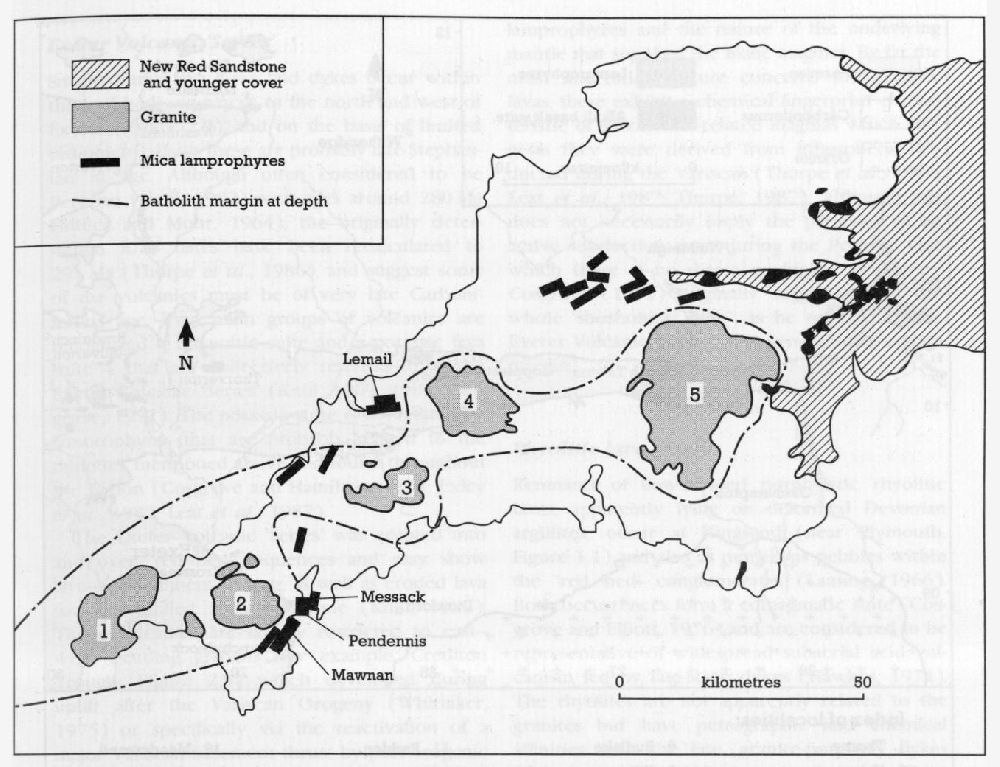
The geography of Cornwall and west Devon is dominated by the granite batholith which constitutes the spine of the peninsula. Like all batholiths, it is made up of many individual intrusions embracing a range of ages and compositions. Although small by global standards and lacking the dioritic and granodioritic components often seen, it compensates for these shortcomings by showing an unrivalled sequence of late- and post-magmatic processes, including mineralization.
The detailed relationship of the batholith with the structural environment outlined above is still somewhat obscure, but from geophysical evidence it is known to extend from a few kilometres east of Dartmoor into the Atlantic west of the Isles of Scilly, a distance of about 250 km. Beyond that, a row of gravity 'lows' extends WSW to the continental margin, and Day and Williams (1970) have interpreted these as being due to granite. If the 'lows' are part of the peninsular granite, then they would extend the length of the batholith to some 500–600 km. Over the Dartmoor–Scilly Isles distance, the batholith varies from about 20 km thick in the east, to half that thickness in the west, and is 40–60 km wide at its base. The Mohorovičič discontinuity beneath southwest England occurs at a depth of approximately 27–30 km (Bott et al., 1958; Bott et al., 1970; Holder and Bott, 1971; Tombs, 1977; Shackleton et al., 1982; Brooks et al., 1983; Brooks et al., 1984). About 95 km WNW of the Isles of Scilly is the small submarine granite outcrop of Haig Fras. This has affinities with the Cornubian batholith and has been interpreted as being separated from it by wrench faulting (Exley, 1966). However, it also contains gneissose material and an alternative suggestion is that it may represent basement that has been thrust northward in a nappe (Goode and Merriman, 1987). A third possibility is that it is related to separate submarine granites of unknown age rumoured to be present closer to Ireland. Day and Williams (1970), for example, consider the Ladabie Bank gravity 'low' (about 40 km north-west of Haig Fras) to be due to granite, but no granite north of Haig Fras was noted in the SWAT seismic survey (BIRPS and ECORS, 1986). Edwards (1984), on the other hand, believes that Haig Fras belongs to a separate batholith parallel to the one exposed on the mainland, and he notes that both have been displaced dextrally.
The most substantial geophysical evidence as to the nature of the base of the batholith comes from Brooks et al. (1984) who have found a southwards-dipping seismic reflector at a depth of about 10–15 km. This is the level at which the densities of country rock and granite merge and Brooks et al. (1984) interpret this reflector as a thrust. Although this conforms well with the general structural picture, it creates a problem by suggesting a separation of the batholith from its original roots and thus from what would normally be the source of hydrothermal and metallic constituents. Shackleton et al. (1982) have included similar thrusts in their interpretation and have proposed that 'the granites were generated farther south and injected northwards as a sheet-like body from which protrusions moved diapirically upwards and by stoping to form the separate exposed granite masses'. They do not specify whether this sheet was magmatic, and their suggestion creates other problems to do with heat, density and vertical and horizontal granite movement, to the extent that granite hot enough to rise diapirically would not also be expected to travel subhorizontally for perhaps 200 km.
The upper surface of the batholith is exposed in a series of seven major outcrops. These are
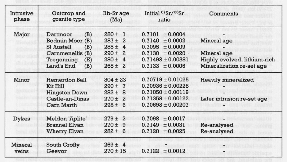
The ages of the exposed biotite-bearing granites indicate that the main period of magmatism lay between 290 Ma and 280 Ma BP, and that this was followed by a second phase some 10 Ma later (Darbyshire and Shepherd, 1985;
The partial melting of the crustal component is envisaged as occurring at pressures of 7–8 kbar and temperatures of about 800°C and, by the time that it reached the present level of erosion and exposure, the granite was manifestly hydrated.
| Intrusive phase | Outcrop and granite type | Rb-Sr age (Ma) | Initial 78 sr/86sr ratio | Comments |
| Major | Dartmoor (B) | 280 ± 1 | 0.7101 ± 0.0004 | — |
| Bodmin Moor (B) | 287 ± 2 | 0.7140 ± 0.0002 | Mineral age | |
| St Austell (B) | 285 ± 4 | 0.7095 ± 0.0009 | — | |
| Carnm.enellis (B) | 290 ± 2 | 0.7130 ± 0.0020 | Mineral age | |
| Tregonning (E) | 280 ± 4 | 0.71498 ± 0.00381 | Highly evolved, lithium-rich | |
| Land's End (B) | 268 ± 2 | 0.7133 ± 0.0006 | Mineralization re-set age | |
| Minor | Hemerdon Ball | 304 ± 23 | 0.70719 ± 0.01025 | Heavily mineralized |
| Kit Hill | 290 ± 7 | 0.70936 ± 0.00228 | — | |
| Hingston Down | 282 ± 8 | 0.71050 ± 0.00119 | — | |
| Castle-an-Dinas | 270 ± 2 | 0.71358 ± 0.00122 | Later intrusion re-set age | |
| Carn Marth | 298 ± 6 | 0.70693 ± 0.00207 | — | |
| Dykes | Meldon 'Aplite' | 279 ± 2 | 0.7098 ± 0.0017 | |
| Brannel Elvan | 270 ± 9 | 0.7149 ± 0.0031 | Re-analysed | |
| Wherry Elvan | 282 ± 6 | 0.7120 ± 0.0025 | Re-analysed | |
| Mineral veins | South Crofty | 269 ± 4 | — | |
| Geevor | 270 ± 15 | 0.7122 ± 0.0012 | — |
It is believed that this state was achieved by the drawing-in of water from the surrounding rocks. That the granite was also cool is evident from the low grade of thermal metamorphism displayed by the enveloping sediments.
In addition to the crustal component, there is an enrichment in such elements as U, Th, F, Cl and Sn, Cu, W, not all of which could easily have been contributed by incorporation of normal crustal material, and which must, therefore, have been derived either from a previously enriched source or by a direct addition from the mantle. The general conclusion (Simpson et al., 1976; Simpson et al., 1979; Lister, 1984; Watson et al., 1984; Thorpe et al., 1986; Thorpe, 1987) is that the latter is more likely, with an addition of radiogenic, halogen and some metallic elements from the mantle. Jefferies (1984, 1988), in a study of radioactive minerals from the Carnmenellis Granite, concluded that these were of magmatic origin, their radio-element content having been derived from fluids circulating in the upper mantle.
Apart from the possible restite origin of some of the xenoliths (Jefferies, 1985a, 1988), the great majority are high-level metapelites or semipelites. Bromley and Holl (1986) have calculated the settling rates of the xenoliths. Most would have been enveloped by the stoping action of the rising magma and sunk within the magma body. They suggest, from their findings, that a seismic reflector found within the batholith at a depth of about 5–6 km. (Brooks et al., 1983) might mark the top of the 'zone of xenolith accumulation'.
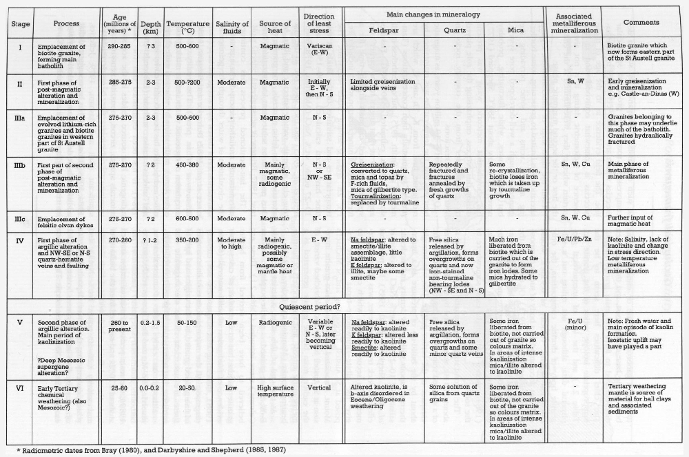
| Process | Age (millions of years) * | Depth (km) | f Stage Temperature
(°C) |
Salinity of fluids | Source of heat | Direction of least stress | Main changes in mineralogy | Associated metalliferous mineralization | Comments | |||
| Feldspar | Quartz | Mica | ||||||||||
| I | Emplacement of biotite granite, forming main batholith | 290–285 | ? 3 | 500–600 | Magmatic | Variscan (E–W) | — | — | — | — | Biotite granite which now forms eastern part of the St Austell granite | |
| II | First phase of post-magmatic alteration and mineralization | 285–275 | 2–3 | 500–?200 | Moderate | Magmatic | Initially E–W, then N–S | Limited greisenization alongside veins | — | — | Sn, W | Early greisenization and mineralization e.g. Castle-an-Dinas (W) |
| IIIa | Emplacement of evolved lithium-rich granites and biotite granites in western part of St Austell granite | 275–270 | 2–3 | 500–600 | — | Magmatic | N–S | — | — | — | — | Granites belonging to this phase may underlie much of the batholith. Granites hydraulically fractured |
| Mb | First part of second phase of post-magmatic alteration and mineralization | 275–270 | ? 2 | 450–380 | Moderate | Mainly magmatic, some radiogenic | N–S
or NW–SE |
Greisenization: converted to quartz, mica and topaz by F-rich fluids, mica of gilbertite type. Tourmalinization: replaced by tourmaline | Repeatedly fractured and fractures annealed by fresh growths of quartz | Some re-crystallization, biotite loses iron which is taken up by tourmaline growth | Sn, W, Cu | Main phase of metalliferous mineralization |
| IIIc | Emplacement of felsitic elvan dykes | 275–270 | ? 2 | 600–500 | Moderate | Magmatic | N–S | — | — | — | Sn, W, Cu | Further input of magmatic heat |
| Iv | First phase of argillic alteration and N–SE or N–S quartz-hematite veins and faulting | 270–260 | ? 1–2 | 350–200 | Moderate to high | Mainly radiogenic, possibly some magmatic or mantle heat
I |
E–W | Na feldspar: altered to smectite/illite assemblage, little kaolinite
K feldspar: altered to illite, maybe some smectite |
Free silica released by argillation, forms overgrowths on quartz and new iron-stained non-tourmaline bearing lodes (NW–SE and N–S) | Much iron liberated from biotite which is carried out of the granite to form iron lodes. Some mica hydrated to gilbertite | Fe/U/Pb/Zn | Note: Salinity, lack of kaolinite and change in stress direction. Low temperature metalliferous mineralization |
| Quiescent period? | ||||||||||||
| V | Second phase of argillic alteration. Main period of kaolinization
?Deep Mesozoic supergene alteration? |
260 to present | 0.2–1.5 | 50–150 | Low | Radiogenic | Variable E–W or N–S, later becoming vertical | Na feldspar: altered readily to kaolinite K feldspar: altered less readily to kaolinite Smectite: altered readily to kaolinite | Free silica released by argillation, forms overgrowths on quartz and some minor quartz veins | Some iron liberated from biotite, not carried out of granite so colours matrix. In areas of intense kaolinization mica/illite altered to kaolinite | Fe/U (minor) | Note: Fresh water and main episode of kaolin formation.
Isostatic uplift may have played a part |
| VI | Early Tertiary chemical weathering (also Mesozoic?) | 25–60 | 0.0–0.2 | 20–50 | Low | High surface temperature | Vertical | Altered kaolinite, is b-axis disordered in Eocene/Oligocene weathering | Some solution of silica from quartz grains | Some iron liberated from biotite, not carried out of the granite so colours matrix. In areas of intense kaolinization mica/illite altered to kaolinite | — | Tertiary weathering mantle is source of material for ball clays and associated sediments |
Attention has been drawn to the K-rich nature of magmas associated with volcanic rocks in South-west England (Thorpe et al., 1986; Leat et al., 1987; Thorpe, 1987). These authors have deduced from isotopic compositions (for example, [87Sr/86Sr]291 = 0.704–0.705; [143Nd/144Nd]291 = 0.5123–0.5127) that they originated in a heterogeneous mantle which had previously undergone modification during a subduction event and that LIL-enriched mantle material might also have contributed to the granites. Leat et al. (1987) have proposed, largely on the basis of high concentrations of heat-producing elements, that potassic magmas originating in the mantle became contaminated by pelitic material to form a gabbroic, dioritic or minette magma body at the base of the crust, and that this then differentiated to form the main granite magma. The chief difficulties here seem to be the inappropriate isotope ratios of the granite (cf.
The second stage of magmatic activity, dated at about 270 Ma, was preceded by the development of a sheeted vein system in fissures opened in the carapace of the earlier granite. This was brought about by the build-up of pressure in a hydrothermal vapour with a low density and moderate salinity of 10–25 equiv. wt.% NaCl (Jackson et al., 1982; Shepherd et al., 1985). Its principal effect in rock terms, however, was the emplacement of a second magma which crystallized to give the albite–zinnwaldite–topaz granite exposed at St Austell, Tregonning and St Michael's Mount. Associated with the Li-mica granite intrusion at St Austell is a Li- and B-enriched variety of the earlier, main biotite granite generated as a metasomatic aureole, and also pockets of fluorite-bearing granite (Manning and Exley, 1984).
At the end of this stage, a series of roughly E–W, fine-grained, granite-porphyry dykes ('elvans') were intruded
Although an early phase of mineralization, involving Fe–Mn and Fe–Cu, was related to pre-batholith sedimentary deposits (Jackson et al., 1989), the main period of mineralization started at about 270 Ma and resulted from the build-up of hydrothermal fluids which were of high density and salinity (20–40 equiv. wt.% NaCl), and which, on entering the cover, deposited a series of roughly E–W-striking veins containing, for example, Sn, Cu, W and As minerals. The violence of such outbursts, accompanied by sudden decompression, sometimes produced spectacular breccias which are usually cemented by tourmaline. The field evidence as to the age of these breccias is somewhat equivocal, and in the absence of radiometric dating it is not always certain whether they were formed at the end of the first or the second magmatic phase.
Until the main stage of mineralization, argillic alteration was limited to greisening, some bordering mineral veins and some pervading the granites through a well-developed pore system, but temperatures, while fluctuating, probably never fell below about 380°C. Sheppard (1977) has shown that meteoric water was present during this process, emphazising the role played by groundwater from the country rocks in hydrothermal reactions.
Over the next 5–10 million years, as magmatic heat was lost, the temperature was maintained by radiogenic heat from K, Th and U, which are present in unusually high concentrations (Tammemagi and Smith, 1975), but nevertheless it fell slowly to an estimated 350–200°C. Fissures approximately at right angles to the earlier vein systems provided channels at this time for a further stage of mineralization which included Fe, Pb, Zn and U among other elements. The temperatures and salinities of the fluids at this time have been calculated at 200–150°C and 19–27 equiv. wt.% NaCI (Alderton, 1978; Shepherd et al., 1985) and they gave rise to the first true clay minerals, namely smectite and illite, by alteration of the felsic minerals. The granite was thus prepared for subsequent kaolinization (Bristow, 1987; Bristow et al. in press).
The last-mentioned process has continued intermittently until the present day as a result of the circulation of water through the granites by convection cells driven by radiogenic heat (Durrance et al., 1982; Durrance and Bristow, 1986; Bristow et al. in press). The reality of the circulation of meteoric water and its mixing with older water, made saline by reaction with plagioclase and biotite, has been confirmed by isotopic and selective cation analysis (Edmonds et al., 1984). It has been established that the main radiogenic heat source resides in the accessory minerals apatite, zircon, monazite, xenotime and uraninite, of which the last is much the most significant (Ball and Basham, 1979; Jefferies, 1984, 1988). However, it has been suggested that additional heat derived from the mantle may also be required (Tammemagi and Smith, 1975), so invoking further speculation about the sub-batholith geology.
Sheppard (1977) has made it clear that the circulating water involved in the main process of kaolinization was meteoric, and it now seems likely that a period of Palaeogene subtropical weathering intensified the alteration already started (Bristow, 1988; Bristow et al. in press). The main stages of evolution are summarized in
Post-orogenic volcanic activity
After emplacement of the batholith and isostatic uplift towards the end of the Carboniferous, south-west England underwent rapid denudation during the Stephanian, Permian and Triassic that eventually unroofed the marginal facies of the granite plutons (Dangerfield and Hawkes, 1969). The eroded desert landscape was subsequently buried by aeolian sands and the pebbly sands and silts of flash floods and fluvial channels (Laming, 1966, 1968). Rapid lateral variations are common and in some cases reflect local contemporaneous faulting (Bristow and Scrivener, 1984). Locally derived debris within the basal conglomerates includes granitic material, aureole metasediments and acidic volcanics (Groves, 1931; Hutchins, 1963; Laming, 1966).
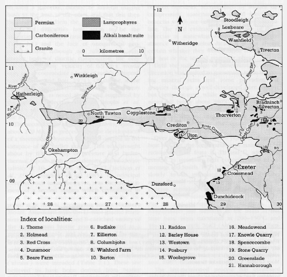
Within this 'red bed' continental environment during the late Carboniferous and probably early Permian period, various small-volume volcanic rocks were erupted. In terms of gross compositional variation, three main suites can be recognized – lamprophyres (limited occurrence throughout Cornubia), Exeter Volcanic 'Series' (restricted to the Crediton Trough and west of Exeter) and rhyolites (only seen at Kingsand, south of Plymouth).
Lamprophyre suite
Throughout south-west England is seen a set of NE–SW-trending minette-type lamprophyre dykes
Exeter Volcanic 'Series'
Small-volume lava flows and dykes occur within the 'red bed' sequences to the north and west of Exeter
The Exeter Volcanic 'Series' was erupted into and over 'red bed' sequences and may show lava–soft-sediment mixing, as well as eroded lava surfaces infilled with sandstone (Knill, 1982). These volcanics are largely restricted to east–west trending grabens (for example, Crediton Trough,
The significance of these volcanic rocks lies not only in their being representative of post-orogenic volcanism, but also in their relationship to the lamprophyres and the nature of the underlying mantle that supplied the mafic magmas. By far the most interesting feature concerns the potassic lavas; these exhibit a chemical fingerprint characteristic of subduction-related magmas which suggests they were derived from lithosphere subducted during the Variscan (Thorpe et al., 1986; Leat et al., 1987; Thorpe, 1987). Although this does not necessarily imply the presence of an active subduction zone during the Permian (for which there is no direct geological evidence), Cosgrove (1972) originally suggested that the whole 'shoshonitic suite', as he referred to the Exeter Volcanic 'Series', was generated at a plate margin.
Rhyolitic lava group
Remnants of flow-banded porphyritic rhyolitic lavas, apparently lying on deformed Devonian argillites, occur at Kingsand (near Plymouth,