An t-Sròn
[NC 443 576]
Introduction
The headland An t-Sròn, on the east side of Loch Eriboll, shows the succession of the lower arenaceous units of the Cambrian sequence in northern Scotland, including some important stratigraphical contacts. Evidence at this site proved central to the resolution of the controversy over the stratigraphy and structure of the northern Highlands of Scotland. The Eriboll and An t-Sròn formations (each with two members), are well displayed in the area and are relatively undisturbed by folding or faulting, and the upward transition to the Ghrudaidh and Eilean Dubh formations of the Durness Group is also exposed.
The site at An t-Sròn played a vital part during the Highlands controversy (Oldroyd, 1990, 1996). At that time, Murchison (Murchison, 1860; Murchison and Geikie, 1861) recognized an upward passage from 'quartz-rock' (now termed the 'Eriboll' and 'An t-Sròn' formations) and 'limestone' (of the Durness Group) into 'upper quartz-rock', overlain by 'upper (or 'eastern') gneiss' (Moine Schist). However, the part of Murchison's interpretation involving the 'upper quartz-rock' was based partly on sections inland (east) of An t-Sròn and near Eriboll House, at which he failed to take account of structural complications. Nicol (1861), who had detected evidence locally for stratigraphical inversion, believed that the upper quartzite was a repetition of the lower quartzite, which had been brought up to the east by folding. Oldroyd (1990) described the background to the clash between these workers and the consequences thereof Nicol's conclusions were partially vindicated by the work of Callaway (1883), but more far-reaching were the results of Lapworth's (1883) detailed mapping. He used the succession at An t-Sròn as a stratigraphical standard and, having mapped the surrounding area in great detail, was able to elucidate the structure and show that the upper quartzite was an isoclinal repetition of the lower quartzite; more importantly, he demonstrated the significance of overthrusting along the Moine Thrust belt. The Geological Survey adopted the same ideas and extended the mapping regionally (Peach et al., 1888) and subsequently gave a detailed description of this area (Peach et al., 1907, pp. 481–486).
Description
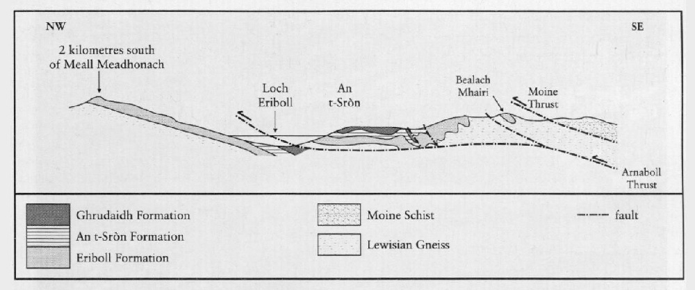
The coastal sections around the An t-Sròn headland and to the south show a complete sequence from the Pipe Rock Member of the Eriboll Sandstone Formation to the Eilean Dubh Formation of the Durness Group. The strata are arranged in a gentle, open anticline (Figure 12.7). On the most northerly point of the headland [NC 4425 5820], the Pipe Rock Member dips at about 12° to the south-west and consists of medium- to coarse-grained quartzites. Beds vary from 5–50 cm thick and are often well jointed. The vertical Skolithos burrows (or 'pipes') that give the formation its name can be seen in plan view on many bedding planes, where they are closely packed and weather out as prominent knobs. Peach et al. (1907) divided this member into several units based on the differing character of the 'pipes', but these have not been substantiated in practice.
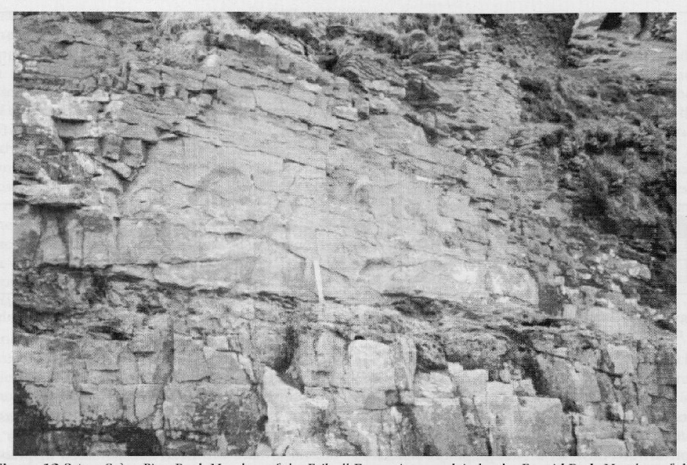
About 60 m southwards from the headland is a low cliff, the base of which shows white quartzites of the Pipe Rock Member but the higher parts of which expose brown-weathering, thinly bedded shales and dolomites characteristic of the Fucoid Beds Member of the An t-Sròn Formation (Figure 12.8). There is a deeply weathered unit at the base of the Fucoid Beds that exhibits bi-directional cross-lamination, above which is a massive sandstone 50 cm thick. Upwards, there are thinly bedded mudstones and siltstones and more massive dolomites about 5 cm thick, weathering to a buff-brown colour; these contain numerous flattened Planolites burrows ('fucoids')., The section along the coast from this point was described by Peach et al. (1907).
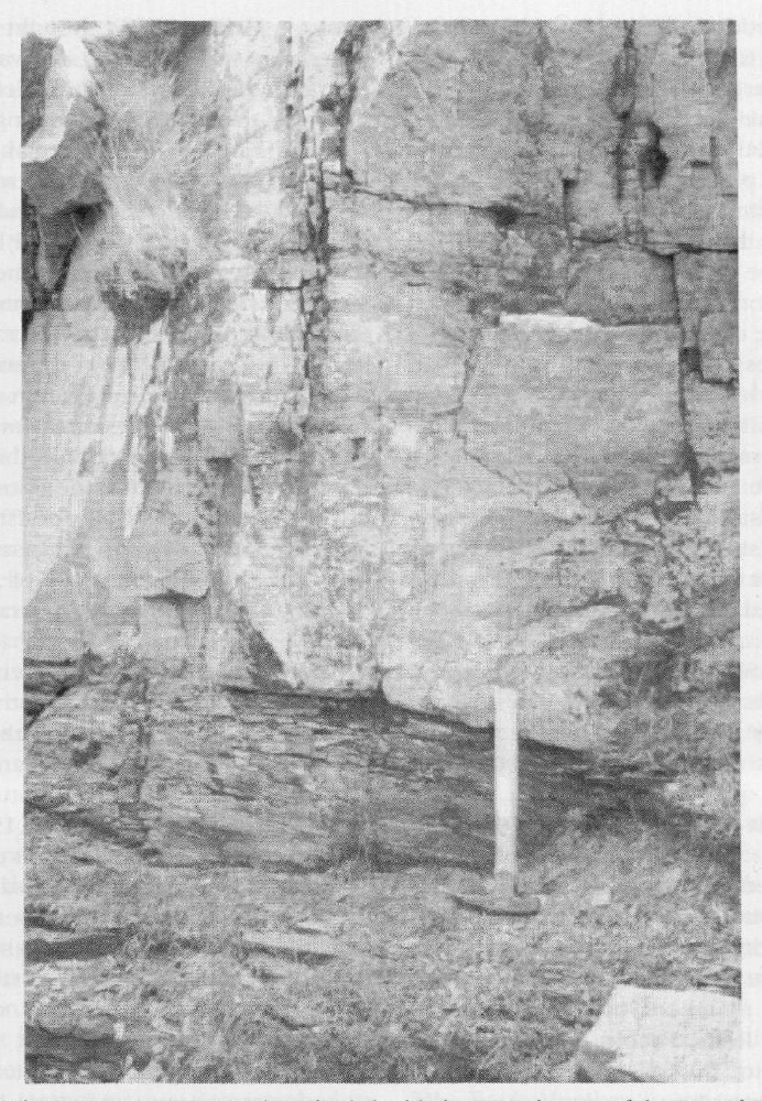
Higher in the sequence, the Fucoid Beds show flaggy, dolomitic sandstones with thin intercalations of dolomitic mudstone. These sandstones are generally 10–15 cm thick but can reach 30–50 cm; they commonly show parallel lamination and occasionally cross-lamination and extend to a small headland [NC 4400 5805]. Towards the top of the promontory are the massive quartzites of the Salterella Grit Member, which slope down to meet the shoreline at the southern end of the small bay beyond it. In the slopes at the back of the bay the highest part of the Fucoid Beds Member underlies the Salterella Grit Member (Figure 12.9). The highest Fucoid Beds consist of fine-grained, cleaved, fissile shales, which weather to a cream-buff colour but are grey-blue when fresh; a bed a few centimetres thick within them has yielded fragments of Olenellus (identified as O. reticulatus in Peach et al., 1907, p. 628). This bed closely resembles the Olenellus layer in the section exposed at Fuaran Mor (see site report).
The Salterella Grit Member consists mainly of thickly bedded quartzites that show large-scale cross-stratification, defined by darker layers. The highest 2 m of these beds consist of pink dolomitic sandstones that are deeply weathered with very distinct surfaces and are pierced by large, vertical burrows and crowded with tubes of Salterella maccullochi (Salter). This distinctive horizon marks the top of the arenaceous units of the Lower Cambrian; and the rocks pass upwards into the dolomitic Ghrudaidh Formation of the Durness Group. The actual boundary forms a slack feature in the cliff. Dolomitic limestones characteristic of the Ghrudaidh Formation, thinly bedded, dark-grey and sometimes mottled, occur for some distance along the coast, dipping south-west at about 40°. The sequence is punctuated at intervals in its upper part by white flaggy dolomites, with layers that show fine parallel lamination and some silicification, and also by a deeply weathered dolomitic horizon (Peach et al., 1907). Folding may cause some repetition of these strata before they pass upwards into the fine-grained, flaggy argillaceous dolomites and limestones of the Eilean Dubh Formation that form the remainder of the exposures southwards along the coast.
Representatives of the various divisions described in the coast section can also be seen on the low hillside above and in the road cutting. The roadside above Kempie House shows the Pipe Rock in the core of an anticline, with Fucoid Beds on either side. Northwards up the road and round the corner, the Salterella Grit and Ghrudaidh formations occur in sequence, although the outcrops become complicated by folding. A good view of the outcrops on the headland of An t-Sròn can be obtained from the roadside to the north. The Pipe Rock quartzites form a prominent feature, and their upper contact with the Fucoid Beds can easily be discerned striking up the hillside.
Eastwards from the broad anticline exposed at An t-Sròn, the Ghrudaidh dolomites are truncated by a reverse fault that brings the Fucoid Beds back to the surface, arranged in two synclines, each fold containing an outlier of Salterella Grit (Peach et al., 1907, p. 482, fig. 21; [NC 448 579]). The beds exposed in one of these folded structures are exposed on the southern side of the road above Kempie House, where the Fucoid Beds and overlying Salterella Grit are almost vertical. Eastwards, the Salterella Grit is brought into contact with the Pipe Rock by a small thrust (Peach et al., 1907). At the corner in the road, white quartzites with vertical Skolithos burrows of the Pipe Rock dip steeply towards the ESE; however, the pipe structures occur on the lower surfaces of these beds, indicating that the strata here are overturned.
The hillside 1 km east of An t-Sròn, towards Bealach Mhairi, presents an important descending sequence, from the Pipe Rock Member through the False Bedded Quartzite Member to the basal conglomerate, which lies unconformably on Lewisian Gneiss (Figure 12.7). Ascending the hill, the crags are mainly white quartzites of the Pipe Rock Formation. They are isoclinally folded, such that some beds show the pipes on the upper surfaces, while others are inverted and show the openings on the lower surfaces. Towards the top of the hill, quartzites of the False Bedded Quartzite predominate. They dip steeply towards the ESE and are thickly bedded, with large-scale tabular cross-bedding in many beds, having set thicknesses of 8 cm to 1 m. Bi-directional cross-bedding can be seen in adjacent units in places.
Above the prominent ridge formed by the quartzitic rocks, the junction of False Bedded Quartzite with the Lewisian Gneiss can be seen. The thin basal conglomerate that is developed locally at the base of the arenaceous beds can be observed in places on Bealach Mhairi, notably in an outlier of isoclinally folded False Bedded Quartzite (Figure 12.7), measuring approximately 140 m by 650 m (Peach et al., 1907, p. 483). The conglomerate is usually 30 cm to 1 m thick, and pebbles consist of well-rounded quartzite, feldspar and felsite in a cream or greenish matrix. Peach et al. (1907) also record fragments of coloured shales. At the junction with the Lewisian, the quartzites and basal conglomerate dip to the ESE at 80° and occur in inverted order, as the beds are overturned; the relationships across this junction suggest a distinct unconformity.
Interpretation
The rocks exposed in the area of An t-Sròn provide historically important sequences through the Cambrian rocks of the north-west Highlands of Scotland. At the coast, the succession through the arenaceous members of the Cambrian, namely the Pipe Rock, Fucoid Beds, Salterella Grit and up into the dolomitic Ghrudaidh Formation, is clear and undisturbed structurally, whereas complicated folding and faulting occurs to the east, considerably affecting the sequence.
The basal conglomerate of the Eriboll Sandstone Formation is well seen to the west of Loch Eriboll around [NC 400 607], about 6 km north-west of An t-Sròn (Peach et al., 1907, p. 391), resting on the Lewisian and signifying a major unconformity (Figure 12.7), with marine planation of the underlying rocks succeeded by marine transgression (McKie, 1993). At An t-Sròn the basal conglomerate is seen in the isoclinally folded outliers east of An t-Sròn, where it was first detected by Lapworth.
Features of the sandstones of the False Bedded Quartzite indicate deposition on a shallow shelf, under the influence of tidal currents (McKie, 1990a), and the overlying Pipe Rock Formation is taken to represent similar environ ments. McKie (1993) thought that the dense burrowing was related to intervals with a slower rate of sedimentation, and recognized erosive intervals that signify shallowing. Hallam and Swett (1966) considered that the Skolithos and occasional Monocraterion burrows characteristic of the Pipe Rock were made by the same organisms, which changed their burrowing habit in response to the rate of sedimentation: slower sedimentation allowed the formation of simple Skolithos-type burrows, while rapid sedimentation led to rapid upward movement of the organisms, with the generation of escape structures. Absence of these burrows in some beds may be due to inappropriate thixotropic conditions or to complete bioturbation. The uniform thickness of the Eriboll Sandstone Formation along its entire outcrop suggests that it is tabular, as would be expected of a transgressive deposit, or that the outcrop parallels the strand-line of a wedge-shaped deposit (Swett, 1969).
The occurrence at the present locality of an Olenellus-bearing horizon in the Fucoid Beds Member allows comparison with other sections, notably that exposed at Fuaran Mor (see site report). Based on detailed studies along the whole outcrop, McKie (19906, 1993) concluded that the Fucoid Beds represent deposition on a shallow, but deepening, storm-dominated shelf. Coarse-grained, tabular cross-bedded and parallel-laminated sandstones, often seen at the base, represent proximal transport of tractional deposits, possibly under tidal influence. The parallel- and cross-laminated silts and finer sands have erosive bases, indicating shelf erosion during storms, and were deposited from suspension as the storm waned. Palaeocurrents from the cross-laminated divisions suggest north to north-west transport, and this may indicate the dominant direction of transport by storms on the shelf. During fair-weather intervals, which were quiescent, the storm beds became burrowed and echinoderm grainstones, found throughout these beds, accumulated. Coarse sandstones that appear towards the top of the Fucoid Beds, though not exposed in Loch Awe Quarry (see site report), are interpreted as a condensed sequence (McKie, 1990b).
The Salterella Grit, with quartzitic sandstones showing cross-bedding and an increase in grain size, represents a brief marine regression (McKie, 1990c) during which conditions were similar to those in which the Eriboll Sandstone Formation was deposited. Subsequently the transgressive trend continued, with deposition of the carbonates of the Durness Group (see the Durness and Balnakeil site reports). McKie (1993) showed that sedimentation on the Hebridean foreland shelf was sensitive to relative changes of sea level, but his suggestion that the Salterella Grit represents the Hawke Bay regressive event (Palmer and James, 1980) is disproved by the discovery of Olenellus in the Ghrudaidh Formation (Huselbee and Thomas, 1998), because it indicates that the deepening that accommodated the Ghrudaidh was already effective at or before the time that the Hawke Bay event commenced. The Ghrudaidh and other formations of the Durness Group are discussed in the Durness and Balnakeil site reports. Huselbee and Thomas (1998) discussed the wider correlation of the Lower Cambrian of the Hebridean Foreland and concluded that the whole sequence lies high in the Lower Cambrian, equivalent to the Branchian Series of Landing (1994), and that the lower and greater part of the Lower Cambrian, equivalent to the Placentian Series, is not represented.
Conclusions
An t-Sròn is important because it exposes sections at which the succession of sandy Lower Cambrian rocks can be demonstrated. It furnishes a stratigraphical standard for the Cambrian rocks of the whole north-west Highlands region of Scotland. Historically, it is the location that provided a vital key to unravelling the structure of the Highlands and where low-angle thrust tectonics were first invoked to interpret British geology.
References


