Chapter 4 Malvern Hills
W.J. Barclay and T.C. Pharaoh
Introduction
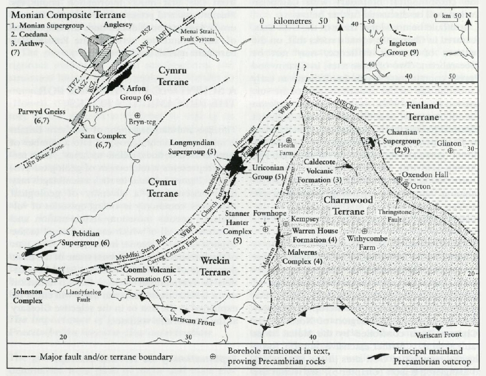
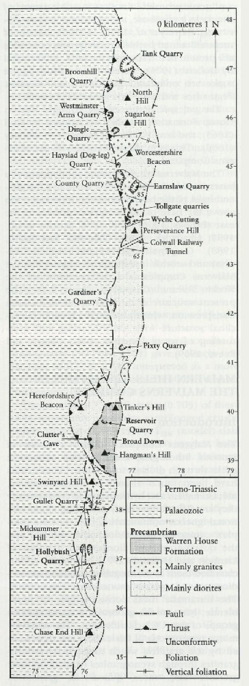
The Malvern Hills collectively form one of the largest of the English Precambrian sites. They provide comprehensive exposures of a heterogeneous calc-alkaline igneous complex, and of a younger volcanic succession, and are consequently a rare window into the early geological history of southern Britain. The hills also bear spectacular testament to the effects of Variscan orogenic forces well to the north of the main Variscan deformation front (see the front cover of this volume). The hard, resistant nature of the rocks results in them forming high ground, here rising to 425 m. The hills comprise a narrow ridge about 12 km long, the 9 km2 outcrop being divided into seven major, fault-bounded blocks (Figure 4.1). All the blocks, except those forming the Tinker's Hill–Broad Down–Hangman's Hill area, are dominated by rocks of the meta-igneous Malverns Complex; Broad Down comprises the volcanic rocks of the Warren House Formation.
The excellent exposures, mostly in quarries, have stimulated much research, including pioneering petrological and geochemical studies. Timins' work published in 1867 was one of the first attempts to study the major element geochemistry of a group of rocks. Rutley's study published in 1888 was one of the first systematic descriptions of the petrography of British plutonic rocks. The strongly layered nature of many of the Malverns Complex rocks led some early workers to suggest that they were paragneisses, formed by the metamorphism of sedimentary rocks (e.g. Homer, 1811; Holl, 1865; Rutley, 1887; Groom, 1899, 1900, 1910). Phillips (1848) and Callaway (1889, 1893) considered them to be of entirely igneous origin, a view later vindicated by Lambert and Rex (1966), Lambert and Holland (1971), Wright (1969) and Thorpe (1982). The Malverns Complex is thus now considered as being largely a heterogeneous, igneous and meta-igneous association of rocks derived by progressive ductile and brittle shearing, and accompanying metamorphism, of a plutonic protolith, the shearing giving many of the rocks a gneissose, mylonitic or schistose fabric (e.g. Barclay et al., 1997). A minor amount of metasedimentary schists (mainly) and quartzites are present in the south of the hills, as discussed by Bullard (1975). In the north, many of the rocks are unfoliated granitoids and diorites. Pegmatites and basic dykes intrude the suite.
The volcanic nature of the younger Warren House Formation was first recognized by Holl (1865), and later confirmed as such by Callaway (1889). This is in thrust contact with the Malverns Complex.
The Malverns are the surface culmination of a basement block which rises 2 km above the general level of the basement to the west and 3 km above the base of the Worcester graben to the east (Brooks, 1963, 1968, 1970; Barclay et al., 1997; Chadwick, 1985; Chadwick and Smith, 1988). Geophysics (gravity and magnetic surveys) and seismic investigations suggest that the Malverns Complex is a representative of the Wrekin Terrane (Chapter 1; (Figure 1.1)). The present structure of the hills is due to Variscan transpression, which produced a broadly monoclinal structure with local thrusting and overturning of strata (Butcher, 1962; Phipps and Reeve, 1969).
References