Barry Island, South Glamorgan
Introduction
The marginal facies of the
The Triassic deposits at Barry Island have been studied for many years (Strahan and Cantrill, 1902, 1904). More recent reports include Anderson (1960), Klein (1962), Tucker (1977, 1978), and Waters and Lawrence (1987).
Description
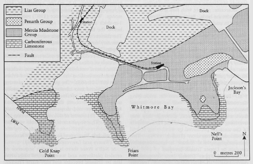
The Carboniferous–Triassic unconformity is seen in the sea cliffs that bound Barry Harbour and Whitmore Bay
The following sedimentary section at Jackson's Bay (ST 12 66), just to the east
| Thickness (m) | |
| ~ 8.7 | |
| Siltstone: green and red mottled, dolomitic | 0.20 |
| Mudstone: red-brown, silty, with three thin, green calcareous siltstones | 0.95 |
| Sandstone: green and red mottled, calcareous, very fine-grained; scattered granules and rare pebbles of Carboniferous Limestone; tabular bedded, laminated and cross-laminated in top 0.03 m | 0.80 |
| Mudstone: red-brown, local green streaks; bed of gypsum nodules, partly dissolved and replaced by calcite, to 0.6 m in middle | 2.16 |
| Sandstone: green and red mottled, calcareous, very fine-grained, in part laminated; mudstone parting in middle; scattered gypsum nodules, partly dissolved and replaced by calcite | 0.55 |
| Mudstone: red-brown, silty to sandy; scattered gypsum nodules, partly dissolved and replaced by calcite, up to 0.45 m; rare, thin, very fine sandstones and siltstone beds | 8.40 |
| Sandstone: green, very fine-grained, calcareous; mudstone parting in the middle; local voids after gypsum; laminated in part | 0.40 |
| Mudstone: red-brown, silty; abundant gypsum nodules, partly dissolved and replaced by calcite | 0.70 |
| 0.15 |
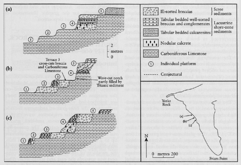
The contact between the Carboniferous Limestones and the Upper Triassic sediments is best seen on the eastern and western flanks of Friars Point. Here, the Carboniferous Limestone was eroded during the Triassic, producing a step-like pattern of wave-cut platforms and cliffs
The basal Upper Triassic beds comprise an exceptionally coarse-grained, massive breccio-conglomerate wedge that is backed up against the cliffs (Anderson, 1960; Tucker, 1977;
The poorly sorted rudaceous sediments pass laterally and vertically into planar-bedded breccio-conglomerates, through calcarenites, into reddish-brown marls (Anderson, 1960; Tucker, 1977, 1978; Waters and Lawrence, 1987), which are often streaked with green and lie on the eroded terrace surfaces. The well-sorted breccio-conglomerates and associated sandstones contain channel structures up to 2 m wide and 0.5 m deep; the arenaceous lithologies (calclithites) preserve wave ripples.
The finer-grained lithologies are characteristic of the 'transition zone' of Waters and Lawrence (1987, p. 55), and consist of mudstones, which may contain clasts of quartz and Carboniferous Limestone, and thin parallel-sided beds (maximum thickness, 0.5 m) of calcareous and dolomitic siltstone and very fine-grained sandstones. Waters and Lawrence (1987) recorded a 1-m-thick arenaceous bed approximately 1.6 m below the base of the
The lateral variability of the sediments is clearly demonstrated on the western flank of Friars Point
At Nell's Point there is a similar sequence of eroded platforms and wave-notched cliffs overlain by Triassic breccias and silty-marls (Tucker, 1977, 1978). On the western side of the headland, the rocks exposed below the footpath provide an excellent example of the transition between the well-sorted breccias, the calcareous sandstones and siltstones, with pebbles and nodules throughout, and the red argillaceous and dolomitic sediments.
At Jackson's Bay
In the eastern parts of the locality, at Nell's Point, the red marls of the lower part of the
Interpretation
The sequence at Barry Island records a history of changing palaeoenvironmental conditions associated with the fluctuating water levels of a large hypersaline water body (Waters and Lawrence, 1987). The five stepped platforms and cliffs
In some places, the eroded surface of the Carboniferous Limestone shows evidence of sheeting, preserved as thin layers of the parent rock aligned parallel to the ancient land surface (Tucker, 1977). This is the result of weathering under arid conditions, and is seen commonly in modern deserts, but is rarely preserved. Similar features were described from Bendrick Rock
The poorly sorted breccias found backed up against the vertical cliff faces have been interpreted as scree deposits. The poorly defined cross-bedding associated with some of these deposits reflects the critical angle of rest of the talus slope (Fucker, 1977). The trough-shaped features have been interpreted as the results of slope failure and scree slumping (Tucker, 1978). These sediments grade laterally into bedded rudaceous and arenaceous rocks and have been interpreted as beach or shoreline accumulations, probably formed by the reworking of the breccia wedges (Tucker, 1977).
The overlying finer-grained carbonate and dolomite-rich red mudstones are typical of deposition under predominantly aqueous conditions (Waters and Lawrence, 1987). Rain drop imprints and mudcracks prove that the argillaceous sediments were periodically exposed to subaerial processes (Klein, 1962).
The sequence of events recorded in the sedimentary record at Barry Island is more complex than the progression from lake-shore erosion, through beach sediment accumulation to subaqueous deposition as outlined above (Tucker, 1977, 1978). The platforms were produced during periods of constant lake level by a combination of wave action and chemical and organic solution of the carbonate-rich rocks, perhaps over many thousands of years. When lake level fell, the scree formed against the cliffs, and the beach sediments accumulated between the cliffs and the open water, often through reworking of the scree slopes. Continued falling water level enabled evaporite minerals, possibly of pedogenic origin, to precipitate within the scree and beach sediments, and they probably took several thousands of years to form. Subsequent rises in lake level resulted in further erosion of the Carboniferous Limestone.
Conclusions
The exposures in the vicinity of Barry Island, and especially those at Friars Point and Nell's Point, provide an excellent example of the marginal rocks of the Upper Triassic of South Wales. The sediments include coarse-grained breccias and conglomerates, as well as sandstones and carbonate- and dolomite-rich mudstones. These rocks were deposited on a series of wave-cut platforms incised into the Carboniferous Limestone around the shoreline of a large hypersaline water body. At times of high water level the lake cut the platforms and cliffs, and marginal deposits on earlier terraces were partially eroded during the creation of the next higher terrace. During periods of low water level the screes associated with the cliffs were reworked as beach deposits. A unique site, and important internationally, for the graphic illustration of shore-face erosion and deposition.