Burntisland to Kinghorn Coast, Fife
D.G. Woodhall
Introduction
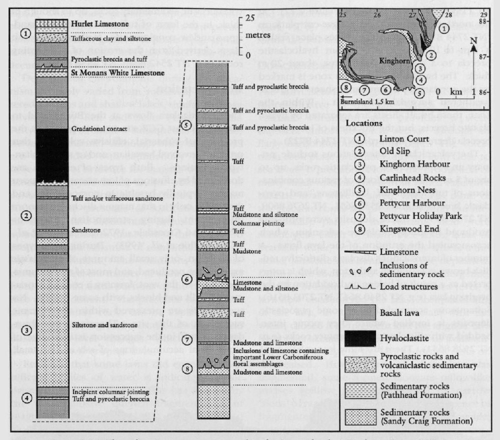
The Burntisland to Kinghorn Coast GCR site incorporates one of the best-exposed successions of Visean volcanic rocks in the Midland Valley of Scotland. The 485 m-thick succession consists of basaltic lavas with subordinate volcaniclastic rocks (hyaloclastite, pyroclastic rocks and volcaniclastic sedimentary rocks).
Notable aspects of the site are the well-exposed internal structures of individual lava flows, a hyaloclastite unit, and occurrences within some lavas of sedimentary inclusions that locally contain important Early Carboniferous floral assemblages. The latter are described in the Palaeozoic Palaeobotony of Great Britain GCR volume (Cleal and Thomas, 1995) from two sites, Kingswood End and Pettycur, which fall within the area of the GCR site described here.
A detailed log of the volcanic succession by Geikie (1900) has formed the basis of most subsequent descriptions (Allan, 1924; MacGregor, 1996). The site was included in a recent re-survey of the Kirkcaldy district by the British Geological Survey (Woodhall, 1998; Browne and Woodhall, 1999, 2000). As a result of this re-survey, the volcanic rocks have been formally designated as the
Description
The Early Carboniferous age of the succession at the Burntisland to Kinghorn Coast GCR site is constrained, outside of the site area, by Asbian to Brigantian miospore assemblages from fluvio-deltaic, lacustrine and marine sedimentary rocks of the Sandy Craig and Pathhead formations (
Lavas dominate the succession, and range in thickness from 5 m to 30 m. They are typically greyish- or brownish-green-weathered, olivine- or olivine-clinopyroxene–microphyric alkali olivine basalts. Amygdales of dark-greenish-grey chlorite and/or pale-yellow calcite are typically most abundant in the lower and upper parts of individual lava flows. Brecciated flow bases and/or tops are apparent locally, but in many cases have been obscured by weathering. Some of this weathering may have taken place soon after the emplacement of the flow, but it is indistinguishable from Quaternary weathering. Many lavas rest sharply on intercalated volcaniclastic and/or siliciclastic sedimentary rocks, and have a regular basal contact. However, those resting on mudstone tend to have an irregular contact owing to the presence of load structures, and some of these lavas contain inclusions of sedimentary rock that were probably derived from the underlying sediment during the emplacement of the flow. At Pettycur
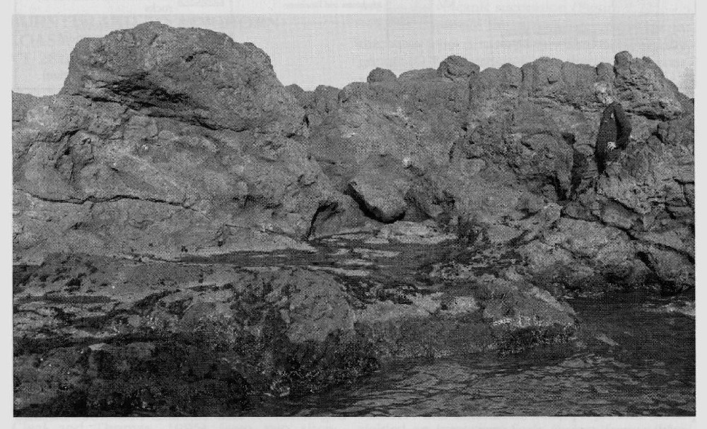
The middle parts of the flows are the least weathered, contain the fewest and smallest amyg-dales, and commonly display cooling joints, which are locally columnar. Columnar jointing occurs in some of the flows exposed in the crags at Kingswood End (Allan, 1924), and on the coast, between Pettycur Harbour and Carlinhead Rocks e.g.
Hyaloclastite, 35–40 m thick in the upper part of the succession, is exposed along the coast northeast of Kinghorn where it forms a 100 m-long wave-cut platform
The volcaniclastic intercalations include primary and/or reworked pyroclastic rocks, up to about 5 m thick, in the form of various combinations of tuff, lapilli-tuff, lapilli-stone, and pyroclastic breccia e.g.
Interpretation
The basaltic lava flows at the Burntisland to Kinghorn Coast GCR site are interpreted as the products of subaerial, effusive volcanism that probably involved hawaiian- and/or strombolian-type eruptions. Both types of eruption are dominated by effusions of low-viscosity, gas-poor magma, typically basaltic in composition, and they differ only in that magma discharge is more intermittent during strombolian eruptions (Walker and Croasdale, 1972; Blackburn et al., 1976; McPhie et al., 1993). During these types of eruption, only small amounts of pyroclastic material are produced, and most of this accumulates close to the vent, forming a cone of scoria-ceous lapilli and blocks, with some bombs. No such cones are preserved within the volcanic succession of this site. Therefore, the abundance of tuff in the succession is indicative of more distal accumulations of ash and/or small lapilli, which were probably deposited downwind from vents. There are only a few occurrences of coarser-grained deposits (e.g. lapilli-stone and pyroclastic breccia), which may have accumulated more proximally.
Depositional environments during the volcanism probably varied from subaerial, with scattered swamps and shallow lakes, similar to those envisaged by Rex and Scott (1987), in the Pettycur area, to shallow subaqueous lacustrine, deltaic and marine. Although many of the lavas are interbedded with sedimentary rocks, the infrequency of evidence for magma–water interaction (e.g. hyaloclastite and/or pillow lava) is consistent with dominant subaerial eruption. However, the presence of load structures at the base of, and sedimentary inclusions within, some flows indicates that some of the lavas were erupted onto a substrate of semi-lithified, possibly wet, sediment. The inclusions are considered to represent masses of sediment isolated from the substrate as portions of the basalt sank into such sediment. The presence of interbedded sedimentary rocks can be explained by a combination of regional tectonic subsidence and eustatic sea-level changes, which repeatedly drowned newly erupted lavas.
Evidence that some lavas did encounter significant bodies of water is indicated by the presence of hyaloclastite. This has formed by the non-explosive quench fragmentation of magma (McPhie et al., 1993). That exposed along the coast north-east of Kinghorn is capped by basalt lava, which displays no evidence of subaqueous emplacement. This relationship is similar to that present in lava deltas, formed as subaerially erupted lava flowed into water (Jones and Nelson, 1970; Moore et al., 1973; Fumes and Sturt, 1976; Cas and Wright, 1987). Consequently, the hyaloclastite north-east of Kinghorn is interpreted as having formed the lower, subaqueous part of a lava delta. The transition upwards from hyaloclastite to basalt lava marks the approximate water level during delta formation, and consequently the 35–40 m thickness of the hyaloclastite provides an indication of minimum water depth. The presence of the trace fossil, Rhizocorallium, in siliciclastic sedimentary rocks immediately beneath the hyaloclastite, suggests that the delta formed during or soon after a marine transgression. The thickness (5–10 m) and complexity (alternating sheets of lava and hyaloclastite) of the transition zone is possibly due to the combined effects of tidal variation and subsidence of the lava delta (Fumes and Sturt, 1976). The overlying coherent basalt lava forms the subacrial part of the delta.
Conclusions
The Burntisland to Kinghom Coast GCR site is representative of the late Visean


