Show interactive timeline
Aird Torrisdale
Y.E. Moorhouse
Introduction
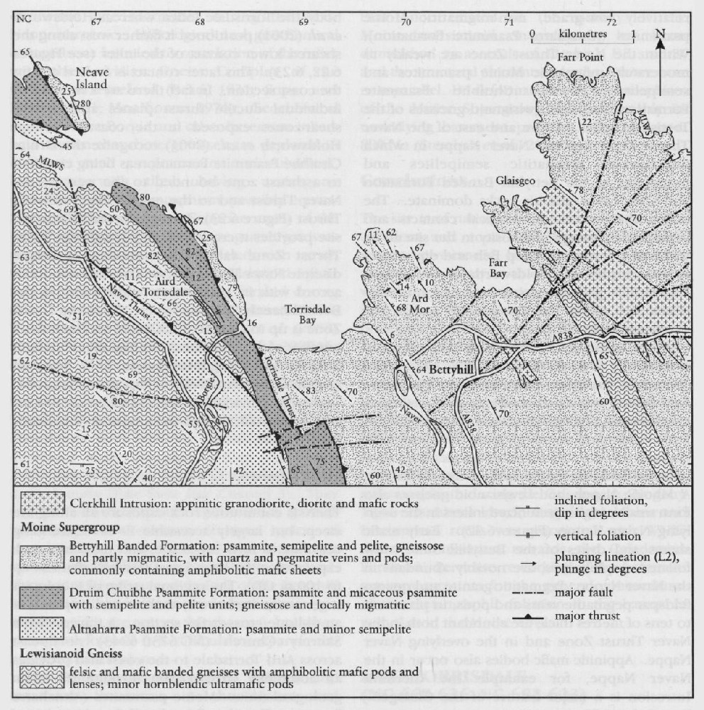
The Aird Torrisdale GCR site provides coastal cliff-sections through the northernmost part of the Naver Thrust Zone, which separates the A' Mhoine and Naver nappes (Moorhouse, 1977; British Geological Survey, 1997b; Holdsworth et al., 2001). The thrust zone is a significant structural boundary that telescopes different stratigraphical, tectonic and metamorphic levels within the exposed Moine succession in Sutherland. Below and west of the Naver Thrust Zone lies the A Mhoine Nappe comprising relatively low-grade, non-migmatitic Moine psammites (
Aird Torrisdale is the most westerly and structurally lowest of four GCR sites (Aird Torrisdale; Ard Mor; Farr Bay; and Glaisgeo–Farr Point) that together effectively constitute a cross-section through the Naver Nappe of north Sutherland. Archaean high-grade felsic and mafic gneisses of the Lewisianoid Borgie Inlier are infolded with the psammites of the underlying
Mhoine Nappe, and Lewisianoid gneisses also form smaller highly tectonized inliers in the overlying Naver Nappe
B.N. Peach first mapped the area around Aird Torrisdale for the Geological Survey in 1886. Moorhouse (1979) revisited the area in the 1970s, and the results of more-recent mapping of the Torrisdale area by I.E. Alsop, I.M. Burns and R.A. Strachan are incorporated in the revised geological map of the Tongue district (British Geological Survey, 1997b) and accompanying Sheet 114E memoir (Holdsworth et al., 2001).
Previous geological accounts of Aird Torrisdale have described a discrete Naver Thrust rather than a zone of thrusting. Moorhouse (1979) placed the thrust along the sheared upper contact of a large Lewisianoid body, the Torrisdale Inlier, whereas Holdsworth et al. (2001) positioned it farther west along the sheared lower contact of the inlier (see Figure 6.22),
Description
There is continuous rock exposure all along the steep, but largely accessible E- to SE-trending coastline of Aird Torrisdale, and moderate rock exposure on the inland peat-clad hills that rise up to 100 m OD. The regional strike of lithologies is generally north-west, so the coastline provides an oblique cross-strike section. A traverse from Skerray Church
The rocks of Aird Torrisdale lie in the Torrisdale Steep Belt, where the regional bedding, gneissic foliation and main cleavage all dip between 50° and 75° to the north-east and east.
The compositional layering and foliation in Naver Nappe to the east mostly have a similarly steep orientation but the Torrisdale Steep Belt flattens out gradually southwards after about 10 km. Within the belt the dominant mineral lineations and fold axes plunge gently to the north-west and south-east, unlike the rocks farther west or east where the lineations and fold axes plunge predominantly down-dip.
Psammites of the N. Mhoine Nappe are exposed on both sides of the Skerray–Torrisdale road where, although deformed, they show prominent bedding; locally remnants of cross-bedding are seen. They are characterized by a steep NE-dipping, composite foliation and steep SE-plunging lineation, both attributed to the main regional Caledonian deformation events (D2 and D3). On the north-east side of the road at
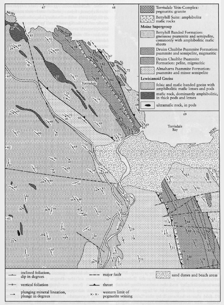
The Lewisianoid gneisses are typically interlayered felsic, mafic and intermediate orthogneisses with subsidiary amphibolite, ultramafic rock, metagranite and granitic pegmatite (Holdsworth et al., 2001). The mafic gneisses consist of medium- to coarse-grained hornblende, biotite, quartz and plagioclase with secondary epidote and accessory titanite, zircon and opaques. Three generations of hornblende were recognized by Burns (1994). A planar fabric, defined in part by aligned hornblende grains, wraps early asymmetrical hornblende poikiloblasts. Late sub-idioblastic hornblende grains randomly overgrow this planar fabric. The biotite-bearing felsic lithologies superficially resemble Moine gneisses, particularly where they are strongly deformed, but they are dominated by plagioclase feldspar, quartz and epidote and their geochemistry is distinctive (Moorhouse, 1976). There are several large amphibolite mafic bodies in the Torrisdale Inlier, typically between 150 m and 800 m long and 10 m to 100 m wide, the largest of which lies north-east of Achtoty at around
There are two critical exposures of individual thrusts within the Naver Thrust Zone in the GCR site area. Near Lon
Interpretation
The Naver Thrust Zone separates the non-migmatitic predominantly psammitic Moine lithologies of the A'. Mhoine Nappe in the foot-wall from the predominantly migmatitic Moine semipelites, psammites and pelites of eastern Sutherland in the hangingwall. The approximate western limit of abundant granite and pegmatite veins within H.H. Read's 'zone of veins' also coincides with the Naver Thrust Zone. The abundance of pegmatites in the Naver Thrust Zone may have resulted from enhanced fluid flow through the thrust system. The veins, part of the
Relict garnet-pyroxene granulites locally occur as kernels in the amphibolites within the Torrisdale and Borgie Lewisianoid inliers. Moorhouse (1971, 1976, 1977) showed that these lenses are petrologically and geochemically similar to ones in Scourian gneisses of the foreland Lewisian. Similarly, the less-foliated and deformed amphibolites in these inliers may be equivalent to mafic dykes of the Scourie Dyke Suite seen in most of the foreland Lewisian outcrops. Moorhouse et al. (1988) inferred that the Lewisianoid gneisses originally formed a crystalline basement unconformably overlain by arenaceous Moine sediments and hence that the present inverted sequence is a result of Caledonian deformation.
The Naver Thrust Zone appears to have a complex and extended history, possibly commencing as early as the Neoproterozoic during Moine sedimentation. It has been the site of Caledonian ductile thrusting probably with major westward movement in both the Grampian (c.
The characteristic steep dips in this area form part of the Torrisdale Steep Belt, which Holdsworth et al. (2001) interpreted as a result of rotation during late-stage (late D3) dextral transpression. Dallmeyer et al. (2001) obtained hornblende and muscovite 4°Ar-39Ar plateau ages ranging from
Conclusions
The Aird Torrisdale site exposes the northern extremity of the Naver Thrust Zone, a major tectonic boundary within the Moine succession of Sutherland. The thrust zone separates the A'. Mhoine Nappe in its footwall from the Naver Nappe in its hangingwall. Moine and Lewisianoid lithologies above and below the thrust zone, as well as individual thrust planes and folds within the zone are well exposed in accessible, cross-strike coastal sections and scattered inland exposures. Bedding, cleavage and all planar structural features dip steeply north-east and lie within the Torrisdale Steep Belt. The main Lewisianoid body, the Borgie Inlier, occurs below the thrust zone in the A'. Mhoine Nappe whereas a smaller body, the Torrisdale Inlier, lies within the thrust zone. The Lewisianoid rocks consist of banded felsic and mafic gneisses of Archaean age with larger amphibolitic mafic bodies and small ultramafic pods.
The lithological differences in the Moine rocks above and below the Naver Thrust Zone are also manifest in the coast section. The thrust zone is responsible for stacking migmatitic Moine psammites, semipelites and pelites of the Bettyhill Banded Formation to the east on top of non-migmatitic Moine psammites, the
The site is of national importance because it provides superb, readily accessible exposures across a major structural boundary within the Caledonian orogenic belt of northern Scotland. The ductile thrust contacts between the Lewisianoid inliers and younger Moine gneisses and within the Moine gneisses are readily seen and ideal for further work.