14 A9 road cuttings and River Garry gorge
[NN 686 717]–[NN 804 656]
P.R. Thomas
Published in: The Dalradian rocks of the central Grampian Highlands of Scotland. PGA 124 (1–2) 2013 https://doi.org/10.1016/j.pgeola.2012.07.009. Also on NORA
14.1 Introduction
The rock exposures in the 20 km-long section of Glen Garry between the Drumochter Pass and Blair Atholl are of national, if not international, importance since they form an almost continuous section through the Grampian Group rocks in the Central Grampian Highlands. Not only does the bed of the River Garry itself have 75% exposure, most of it above water level for much of the year, but the parallel A9 road also provides a series of long clean rock cuts. Hence, the exposures are frequently visited by student parties and professional geologists. The GCR site is noteworthy for its wealth of minor folds and sedimentary structures, which can be used to demonstrate the position and geometry of some of the major folds that make up the central part of the Grampian fold belt.
The site lies on the inverted limb of the recumbent, SE-facing Tay Nappe and provides a unique section through D1 and D2 minor and major folds, related to that regionally important structure. It also provides an essential link between two later major upright folds, the Drumochter Dome to the north-west (see (Figure 3.32)) and the Ben Lawers Synform to the south-east (see the Ben Lawers GCR site report); those are the folds that control the outcrop pattern of the Dalradian in much of the Central Grampian Highlands, as illustrated and discussed by Treagus (1987, figure 1b and p.12).
The rocks of Glen Garry were originally described by Barrow (1904) as Moine ‘granulites’ (an obsolete term for high-grade psammitic metasedimentary rocks). The paper mentions ‘water-pipe’ structures at Clunes and some overturned folds, but provides little other specific data. Apart from a brief description of a fold in a quarry on the A9 road by McIntyre (1950), the main work, which forms the basis for this account, is that of Thomas (1965, 1979, 1980, 1988). Further useful comments were made on the sedimentology by Glover and Winchester (1989) and Banks (2007), and on the structure by Lindsay et al (1989).
14.2 Description
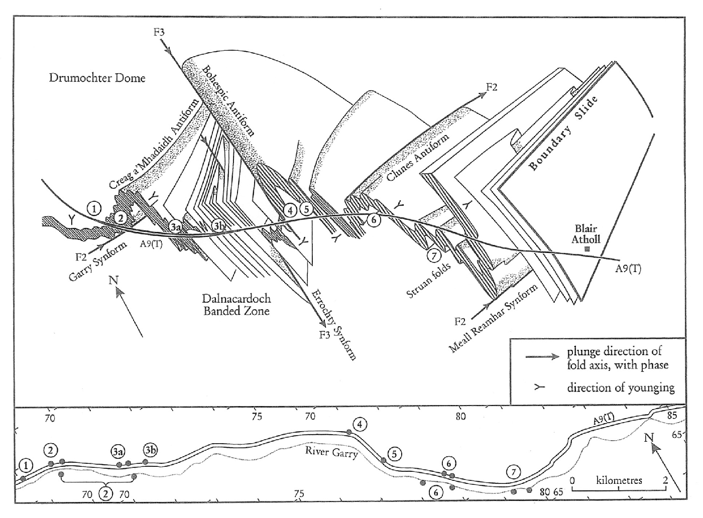
The following numbered descriptions of key localities start in the north-west, near the summit of Drumochter Pass, and follow the road and river down towards Blair Atholl (Figure 3.32). All of the exposures are within psammitic rocks of the Grampian Group. The dominant fold-set is named F2 and its axial plane schistosity S2. Rarely observed folds which clearly pre-date F2 or S2 are designated F1, although S1 is generally parallel to bedding.
14.2.1 Stalcair Cut
[NN 686 717]
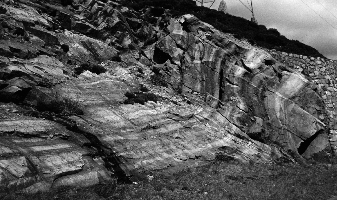
At the third lay-by on the southbound section of the A9 dual carriageway descending from the Drumochter Pass, gently dipping inverted beds face down to the south-east on the S2 axial-plane schistosity and lenses of calcsilicate rock in the schistose psammites are well seen. Roadside exposures 200 m to the east, by a pylon buttress, display schistose laminated psammites with superb trough ripple-laminations and larger dune beds as well as sediment slump structures (Banks, 2007; (Figure 3.33)). Overturned, NW-vergent, F2 folds in the cut face plunge gently towards 070° and are clearly downward facing. A strong S2 axial-plane cleavage cuts S1, which is parallel to bedding,and dips at 300 towards 1600 at this locality. The exposures are on the north-west, inverted, limb of the F2 Garry Synform, the hinge-zone of which is seen at locality 2.
14.2.2 Wade Stone Cut
[NN 694 716]–[NN 699 71] and River Garry [NN 697 714]–[NN 714 706]
At the fourth lay-by on the southbound dual carriageway, a high rock face, on the curve of the road, cuts obliquely across the hinge-zone of a major F2 fold, the Garry Synform. The section east of the lay-by is in the gently dipping inverted limb of the synform, with NW-verging minor folds, but east from the retaining wall F2 minor folds become more neutral in vergence as the hinge is reached. The folds, plunging at 20° to 070° with an axial-plane dip of 40° to the south-east, are downward facing. Evidence is based on the many fine examples of ripple-laminated and dune-bedded schistose psammites. Lenses of calcsilicate rock are deformed by S2, but post-D2 microcline porphyroblasts in the schistose psammites could be evidence of later metasomatism.
There are both early quartz veins, which are folded, and later cross-cutting veins. NE-trending microdiorite dykes and faults can also be traced in the rock-face. The major Allt an Stalcair fault-zone, seen in the Allt Stalcair at [NN 693 717] to the west, is mineralized with calcite and haematite.
The northbound lay-by, nearer to the River Garry, enables both road and river sections to be seen. Good way-up evidence is found in the river beneath the railway bridge [NN 6995 7131], and immediately upstream is the hinge of the Garry Synform. One kilometre downstream from the railway bridge, the hinge of the major F2 Creag a’ Mhadaidh Antiform can be traced [NN 7090 7075], plunging at 10–14° to 070–080° with fine examples of overturned folds containing trough cross-laminations on steep limbs and an S2 crenulation schistosity dipping at 20–30° to the south. Exposures around the footbridge at [NN 7120 7065] have considerably tightened and overturned minor folds involving some refolding of F1 folds. These continue downstream to a point where very regular low dips mark the commencement of the ‘Dalnacardoch Banded Zone’ (see locality 3b), about 200 m upstream from the confluence with the Edendon Water.
14.2.3a Edendon Cut
[NN 7108 7084]–[NN 7140 7075]
The next lay-by on the A9 southbound is east of the major F2 closure of the Creag a’ Mhadaidh Antiform. At the west end of the rock cut [NN 7114 7083], very tight F1 folds verge north-west and appear to face downwards to the south-east as indicated by deformed current-ripple laminations. At the burn [NN 712 708] a strike-slip fault trending 024° brings in a more-psammitic lithology and overturned, NW-vergent, F2 folds plunging at 16° to 075°. At the east end of the lay-by, above a low-dipping ductile thrust, slightly more-open F2folds plunging at 20° to 082° with an axial-plane schistosity dipping at 35° to the south, fold thin quartz veins and are cut by a microdiorite dyke.
14.2.3b Dalnacardoch Cut
[NN 719 705]
Half a kilometre south-east of the last locality, in the deep southbound road cut, an apparently regular sequence of flaggy to schistose psammites dipping at between 25° and 30° is far more complex when closely inspected. This is the ‘Dalnacardoch Banded Zone’, which envelopes very tight F1 and F2 folds as well as a later generation of reclined folds on both major and minor scales. At the north-west end of the highest section [NN 7183 7055], very tightly refolded isoclines occur, whereas farther into the cutting isoclinal folds lie within an apparently simple banding [NN 7198 7046]. The cutting also contains bands of mixed gneissose lithologies, in which post-D2 boudins are quite common. Late rotational shears in the form of large kink bands also occur at the eastern end of the cut.
In the River Garry, the Dalnacardoch Banded Zone is at least 4 km wide from [NN 716 706] to [NN 748 694] and contains both F1 and F2 folds, as well as folds of a later deformation. The latter are associated with the north-west limb of the major post-D2 Errochty Synform, which is thought to pass through the River Garry near Dailnafraoich [NN 7375 6983]; here, exposures of F1 and F2 isoclines are refolded about reclined folds of the later generation, which plunge at 10–30° to 140–170°. The river also exposes a number of interesting crush-zones parallel to banding in which angular schistose clasts are preserved in narrow breccia bands less than a metre in thickness.
14.2.4 Allt Crom Cut
[NN 769 690]
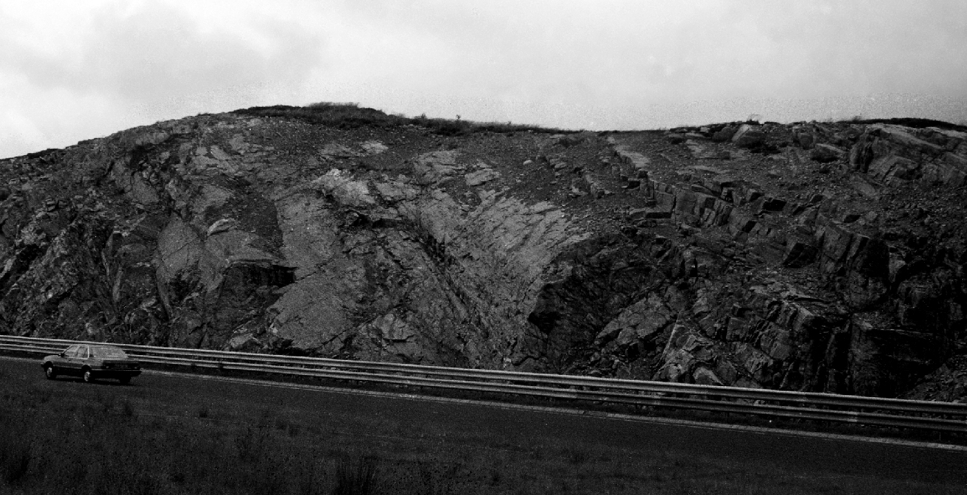
Just to the west of the Allt Crom bridge on the A9 road, a cutting at [NN 7688 6896] exposes the hinge of a major antiformal fold in three dimensions (Figure 3.34). Plunges of both major and minor folds here are in the range 16–25° towards 150–170°, but strong axial cleavage planes appear to be restricted to the hinge-zone, where they dip at 40° to 080°. The western limb dips at 35–45° towards 080° and the less-steep eastern limb dips at 20–30° towards 135°; the interlimb angle from here northwards remains at less than 40°. This undoubted major hinge can be traced for 1 km north in surface exposures and also in the Allt a’ Chireachain, 3 km to the north, at [NN 7752 7194], where the plunge is 20° to 140°. In the Garry Gorge immediately to the south, it is difficult to follow the precise trace of the antiform; it is seen towards Glen Errochty, though in a much more-open reclined style at this higher structural level. This fold is equated with the Bohespic Antiform, the major post-D2 fold complementary to the Errochty Synform (see below).
14.2.5 Black Tank Cut
[NN 773 680]
This wide cutting is dominated by a major, tight, overturned F2 antiform, the hinge of which can be detected opposite the northbound lay-by in schistose psammites dipping at 38° to 116°. The plunge is unusual for the area at 8° to 218° with a cleavage dip of 30° to 136°. The high rock face is controlled by regularly dipping planar structures 1–3 m apart with a dip of 52–55° towards 270–290°. Some joint faces are mineralized with quartz and pyrite whilst other fault planes display slickensides, some with dip-slip and others involving strike-slip final movements. Several of these discontinuities caused wedge failures of the face during construction. At the south-east end of the cut a large red microdioritic sill, dipping to the east at 26° in very regular layers of schistose psammite, is downfaulted to the north-west.
14.2.6 Clunes Gorge
[NN 782 671]–[NN 789 667] and Clunes Cut [NN 785 670]–[NN 789 668]
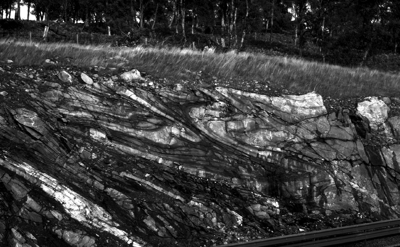
This superb river locality has now been rivalled by the new road cut only 150 m to the north (Figure 3.35). Both localities demonstrate the presence of the Clunes Antiform, a major F2 structure, folding cross-bedded and ripple-laminated psammites, quartzites and semipelites, stratigraphically located near the transition between the Bruar Psammite Formation and the Tummel Quartzite and Psammite formations. Linear features seen in the river section, such as the famous `water-pipe’ mullions [NN 784 667] (Barrow et al., 1905, p. 68), plunge consistently parallel to the axes of the F2 minor folds. Minor folds, abundantly displayed in the road cut (Figure 3.35), plunge consistently at about 10° to 045°, with a strong S2 axial-planar cleavage dipping at 20–30° to 120°. At both localities the SE-vergent, overturned, folds can be seen climbing towards the hinge of the major antiform, which lies near the south-east end of the cut and some distance down the Clunes gorge [NN 787 667]. The sedimentary structures consistently show that the section is inverted overall and that the F2 folds face downwards to the south-east.
Several vertical and inclined microdiorite dykes cut both the river and the road sections. The widest of these is not only porphyritic but also contains xenoliths made up from a variety of metamorphic rocks, some of which are quite distinct from normal Grampian Group lithologies. Immediately west of one of the dykes, at the north-west end of the road cut, early, presumed F1, isoclinal folds can be seen to be refolded by the F2 minor folds.
Downstream around [NN 790 664], major faults cut the river section and start to bring in lithologies that can be assigned more-readily to the Bruar Psammite Formation.
14.2.7 Struan Exposures
[NN 802 657]–[NN 808 655]
Inverted, regularly SE-dipping, flaggy psammites and quartzites form the bed of the River Garry for 1 km below the junction with the Allt a’ Chrombaidh [NN 790 664], but from 200 m above the twin bridges at Calvine [NN 802 657] and downstream almost as far as Struan church [NN 808 655], numerous overturned F2 folds have been entrenched by the river. These NW-vergent folds have consistent plunges of 20–30° to 060°, and amplitudes of 5–20 m.
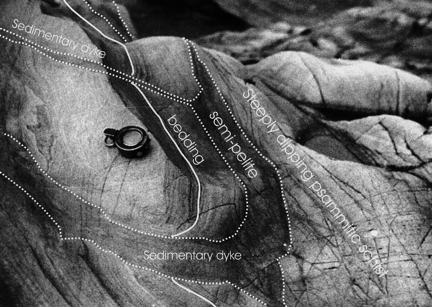
At the ‘Salmon Leap’ [NN 8037 6565], sedimentary structures are best preserved on the steep limbs of the folds, in laminated schistose psammites with interbedded semipelitic layers. The proof that the layering is true bedding lies in the presence of a number of well-preserved sedimentary dykes, washouts and slump structures (Figure 3.36), all of which consistently young to the south-east on steep limbs of folds, which thus face down to the south-east as at Clunes (locality 6). The rocks here are assigned to the topmost part of the Bruar Psammite Formation.
14.3 Interpretation
In essence, the sections at localities 1 and 2 and 4 to 7 are dominated by minor and major folds of the second generation, which fold all earlier planar structures (S0 and S1). In the more-pelitic lithologies, a strong crenulation cleavage is developed, axial-planar to the folds. Both the folds and the cleavage can be correlated, in style and geometry, with the regional D2 structures. The three-dimensional structure of the area is made more complex by the presence of a third deformation phase, described by Thomas (1980) as D3but which is thought by others to pre-date the ENE-trending upright folds described as F3 by Treagus (1999, 2000) in the Appin and Argyll group rocks south of the Rannoch–Tummel area. Treagus (2000) gave these late structures a local designation of De, being unable to state categorically whether they pre- or post-date the regional D3 phase.
This late phase is associated with the major N-S-trending Errochty Synform and the Bohespic Antiform, described by Rast (1958) from the boundary of the Grampian Group with the Appin and Argyll groups to the south (see the Meall Dail Chealaich GCR site report). Minor structures associated with this phase become remarkably intense in the mid-part of the Glen Garry section, where the Errochty Synform produces the tight reclined structures at locality 3. This gives rise to the Dalnacardoch Banded Zone, which destroys most of the stratigraphical continuity and causes the re-orientation of all earlier folds around its hinge. Since no sedimentary structures are preserved in this high-strain zone, it is possible that bedding has been transposed and the schistosity might be composite. The presence of well-preserved sedimentary structures outside the banded zone introduces the possibility of some stratigraphical subdivision but the psammitic nature of most of the lithologies reduces the confidence of correlations north and west of the Dalnacardoch area.
In spite of the refolding by this later fold-pair, the major F2 folds described above, and the majority of the minor folds on their long limbs, are consistently overturned and vergent to the north-west, whilst being downward facing to the south-east on the second cleavage (Figure 3.32). The Garry Synform and the complementary Craig a’ Mhadaidh Antiform demonstrate this relationship particularly well on the north-west limb of the Errochty Synform. In the core of the Errochty Synform and on its common limb with the Bohespic Antiform, between localities 2 and 4, the facing of the D2 structures is not clear. However, on the south-east limb of the Bohespic Antiform the north-west vergence and south-east facing of the D2 structures is very clear from the exposures of the Clunes Antiform, seen in conjunction with the Meall Reamhar Synform (see the Creag nan Caisean–Meall Reamhar GCR site report). It is likely that the Clunes Antiform is the lateral equivalent of the Creag a’ Mhadhaidh Antiform.
The geometry, north-west vergence and south-east facing of the D2 structures is consistent with that observed in the Appin and Argyll groups to the south (see, for example, the Strath Fionan, Slatich and Craig an Chanaich to Frenich Burn GCR site reports). This is consistent with their origin on the lower limb of the Tay Nappe, in its development during top-to-the-SE D2 simple shear of originally upright F1 folds (Treagus, 1987). This concept is supported by the observation, in the Clunes locality particularly, that the sedimentary structures are best preserved in the steeply dipping, short limbs of the F2 folds, where they have suffered the least rotation and deformation. The rarely observed minor first generation folds also appear to be facing down to the south-east, on the long limbs of second folds. This suggests that, on the removal of the second deformation, these folds would have been part of an upward-facing fold train (see 1.1 Introduction), originally on the south-east limb of a major F1 anticline.
14.4 Conclusions
Glen Garry, from Drumochter to Calvine, is traversed by two parallel, excellently exposed ribbons of rock, one natural (the River Garry) and one man made (the A9 road). Both have been instrumental in providing vital evidence to help our understanding of the complex geological structure of the Grampian Group and without them very little three-dimensional interpretation of the structure would have been possible. Both minor and major folds, as well as sedimentary structures, are clearly and spectacularly displayed in exceptional clean and continuous exposures of rocks that are poorly exposed elsewhere. Most of the folds belong to the regional D2 phase of deformation, are north-west verging and face downwards to the south-east on the inverted lower limb of the F1 Tay Nappe. However, this site also exposes the hinges of an important pair of later folds, the Bohespic Antiform and the Errochty Synform, which exert a major influence on the overall outcrop pattern in the Schiehallion area to the south.
References

