12 Ben Alder
A.G. Leslie and C.J. Banks
Published in: The Dalradian rocks of the northern Grampian Highlands of Scotland PGA 124 (1–2) 2013 https://doi.org/10.1016/j.pgeola.2012.07.010 Also on: NORA
12.1 Introduction
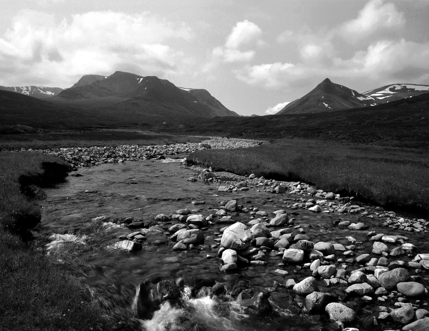
The Ben Alder GCR site comprises the whole of the eastern flank of the mountain
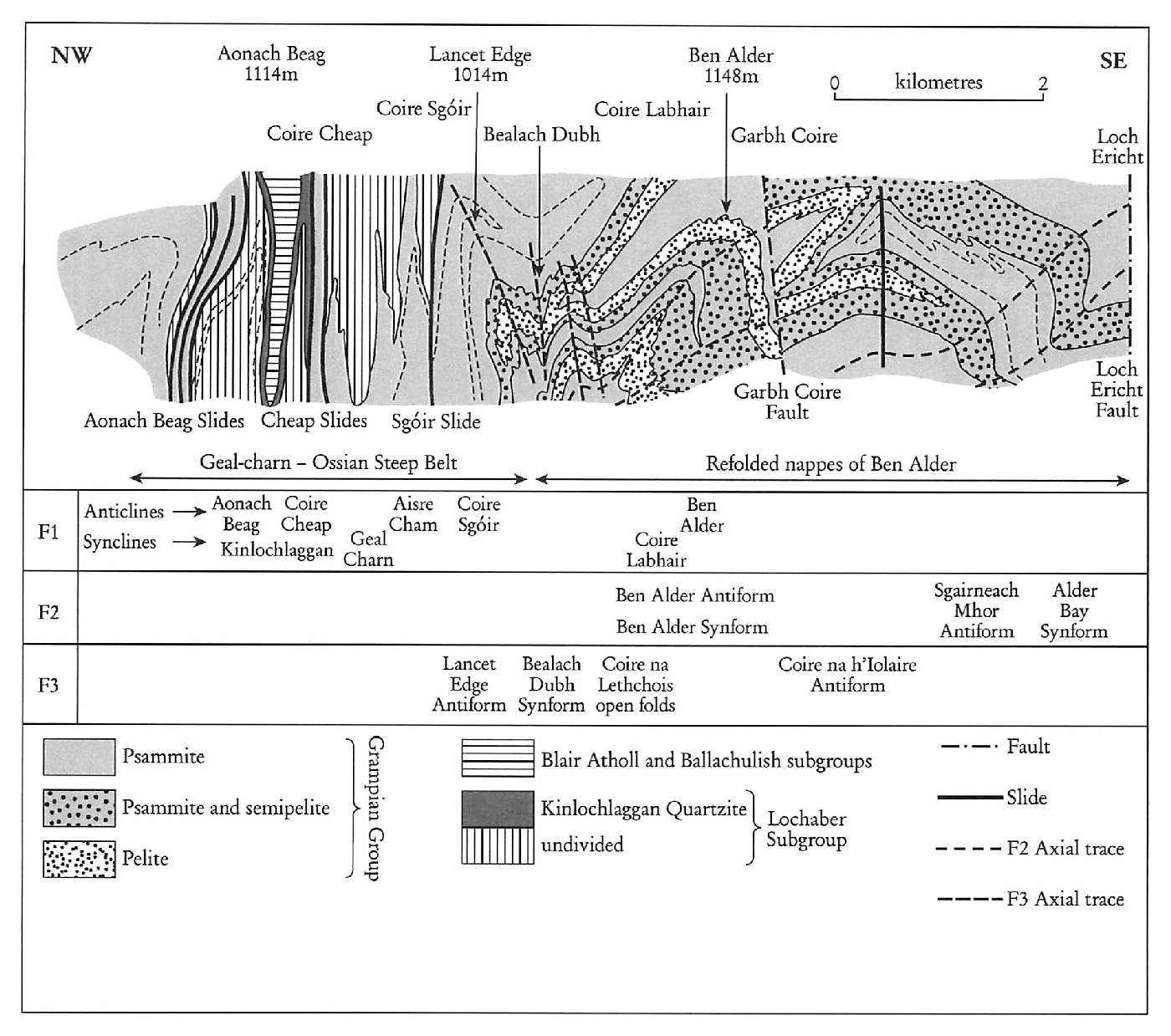
The summit of Ben Alder stands at 1148 m in the midst of an extensive plateau with much ground above 970 m, some 10 km from the nearest 4-wheel-drive track and 15 km from the nearest road. The cliffs on the north-western flank and in the imposing eastern corries are over 200 m high. The remote and mountainous nature of the terrain has no doubt led to the paucity of geological investigations. The area was originally surveyed by the Geological Survey, who identified a number of ‘sharp folds’ whose ‘true nature and value are unknown’, deforming ‘quartz-biotite-granulites of the Moine Series’. It was concluded that it was ‘impossible to decipher the structure of the Ben Alder plateau’ (Carruthers in Hinxman et al., 1923). Thomas (1979) provided the first detailed account of the country between Loch Ericht and Loch Treig, which includes the great corries on the north-east face of Geal-charn (the Aonach Beag and Geal-charn GCR site) and those of Ben Alder. Much of the structure relevant to the Ben Alder area is represented on the BGS 1:50 000 Sheet 63E (Dalwhinnie, 2002), although this GCR site lies along strike to the south-west, entirely within the adjacent Sheet 54E (Loch Rannoch).
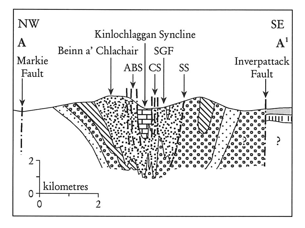
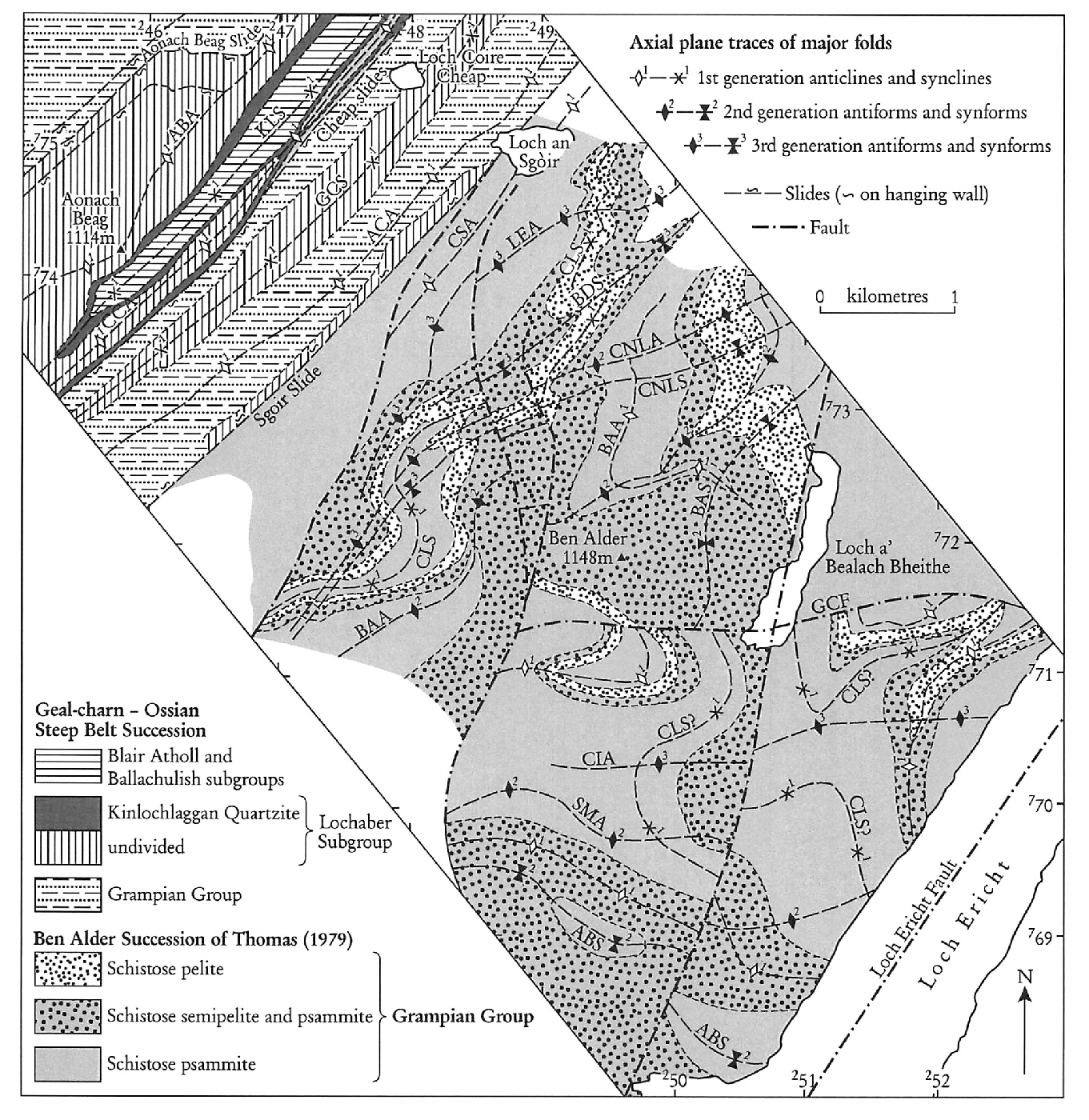
Thomas (1979, 1980) recognized major changes in facing across early recumbent structures affecting a ‘Moine’ succession in the Ben Alder area to the south-east of the Geal-charn-Ossian Steep Belt. He regarded the area as critical to any understanding of potential stratigraphical and structural linkages between the NW-facing nappes that had by then been recognized in the Loch Leven district (Treagus, 1974; Roberts, 1976) and the SE-facing nappes of Glen Orchy (Thomas and Treagus, 1968), Strathtummel (Thomas, 1980) and the Southern Highlands (Harris et al., 1976; Bradbury et al., 1979). The model proposed by Thomas (1979) had major nappes diverging to the north-west and south-east from either side of the upward-facing Geal-charn-Ossian Steep Belt, which in effect acted as a fundamental root-zone (see Stephenson et al., 2013a, fig. 10a). In the Ben Alder area, the early SE-facing nappe structures were refolded by two further phases of folding.
Robertson and Smith (1999) examined many of the critical sections across the Geal-charn–Ossian Steep Belt in Coire Cheap and Coire Sgòir. That work essentially confirmed the presence of
12.2 Description
The following description is drawn largely from the maps and comments within publications by Thomas (1979, 1980), supplemented where appropriate by more-recent work by the British Geological Survey, mainly on the adjacent 1:50 000 Sheet 63W (Dalwhinnie, 2002) (Robertson and Smith, 1999). The most-recent BGS work (2005–2006) extended that re-assessment southwards onto the Ben Alder massif itself and will rationalize the regional stratigraphical relationships within current understanding of the
Thomas (1979) referred to a ‘Moine succession’ rich in strongly striped and banded schistose semipelite and psammite, interleaved with much thicker units of schistose pelite and gneissose psammite. A few pods and lenses of calcsilicate rock occur throughout. These lithologies are likely to be assigned eventually to the sequence of
Thomas (1979, 1980) considered that the upright pattern of folds in the Geal-charn-Ossian Steep Belt is transformed to the south-east, over 2–3 km across strike, into broadly recumbent nappe structures, which have been refolded by second and third generation upright structures
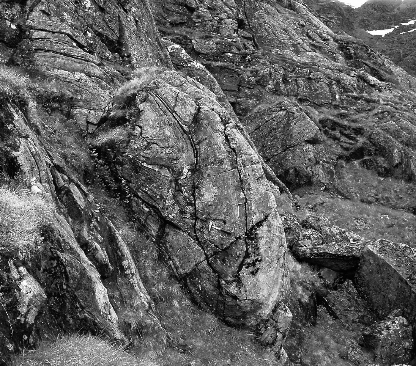
The Sgòir Slide lies along the south-east margin of the steep belt. This slide lies on the north-western limb of the F1 Coire Sgòir Anticline and is marked by tight folding, migmatization, and loss of good bedding features. The slide juxtaposes
In the upright core of the Coire Labhair Syncline, where it crosses Lancet Edge
The closure of the complementary F1 Ben Alder Anticline is less clear and is dependent upon assessment of lithological repetition eastwards towards Coire na Lethchois and Garbh-choire Beag
According to Thomas (1979), the major change in trend of the F1Ben Alder Anticline occurs across the trace of the NE-trending F2 Ben Alder Antiform; the latter structure was identified in cross-section in the cliffs in Garbh-choire Beag
Rather symmetrical open F3 folds, which deform both the D1 and D2 structures, are present as a fold-pair in Coire na Lethchois
South of the Garbh Coire Fault
12.3 Interpretation
Thomas (1979, 1980) described local successions of what is now termed the
Thomas’ succession for the Ben Alder area comprised three psammite-dominated, and two semipelite-and-pelite-dominated units. Whilst Robertson and Smith (1999) recorded a strikingly similar sequence for their
Establishing the lithostratigraphical succession on Ben Alder, and hence the structural architecture, was apparently more problematical than it was in the steep belt (Thomas, 1979). This was largely due to the apparent lack of sedimentary structures and evidence of younging, compounded by the superimposition of polyphase folding on a major scale. More-recent work farther to the north and north-west, notably on Loch Laggan side and in Glen Roy has recognized sedimentary rocks of the
The Ben Alder GCR site is centred upon the northern part of the Ben Alder massif where Thomas (1979) recorded his evidence for D2 and D3 refolding of the primary nappe structure on the south-east flank of the steep belt. The earliest folds were considered to change from an upward-facing, upright form in the steep belt to more-recumbent SE-facing structures, (ultimately downwards-facing to the south-east) as they were traced south-eastwards away from the steep belt, across the Drumochter Dome and into the Atholl Nappe-complex in the footwall of the Boundary Slide in the Blair Atholl district (see 1.4.1 in Introduction). The NW-facing structures in the Appin and Lochaber districts were represented as a ‘mirror-image’ emerging from the steep belt to the north-west. Thus the Geal-charn-Ossian Steep Belt was envisaged as a root-zone to both the SE-facing and the NW-facing nappes of the Central Grampian Highlands.
In this scenario, Thomas regarded the Drumochter Dome as an F2 structure (Thomas, 1979, figure 6). However, Lindsay et al. (1989) demonstrated that S2 axial planes and cleavages are folded across the dome, which is consequently now generally accepted as a later structure, possibly F3 as originally proposed by Roberts and Treagus (1977c, 1979) for the related domes of Glen Orchy and Glen Lyon or F4 of other authors. Thomas (1980, 1988) regarded the Meall Reamhar Synform of the Blair Atholl district as the F1 closure of the SE-facing Atholl Nappe but in the light of work by Treagus (1987, 2000) this fold is now regarded as an F2 structure. The most-recent structural interpretations of the Grampian Highlands emphasize the importance of the D2 deformation (rather than D1) in relation to the generation of the major nappes (Krabbendam et al., 1997; Treagus, 1987, 2000) and it seems likely that a similar modification of the structural chronology of the polyphase folding displayed on the Ben Alder massif will be appropriate, with the major recumbent folds essentially D2 in age rather than D1. However, the presence of F1 folds of significant magnitude cannot be discounted at this stage.
Robertson and Smith (1999) broadly agreed with Thomas (1979) on the structural architecture within the steep belt but dismissed the idea of a root-zone for emergent nappes. Instead they argued that the steep belt forms the boundary between contrasting structural domains, with primary upright structures to the north and west and recumbent folding to the south and east
12.4 Conclusions
The area around Ben Alder has been central to debates concerning the existence or otherwise of a root-zone for the regional nappe-complexes of the Central Grampian Highlands. It was believed that the nappes were ‘squeezed out’ on both sides of a zone of steeply dipping rocks, now called the Geal-charn–Ossian Steep Belt, which is well exposed in the adjacent Aonach Beag and Geal-charn GCR site. This in effect created a mushroom-shaped ‘fountain’ of nappes in which individual nappes were separated by ductile dislocations termed slides. Away from the steep belt to the south-east the primary F1 nappes became highly inclined, SE-facing, and all of the structures were subsequently refolded by more-upright folds of at least two generations (F2 and F3), resulting in the observed pattern of recumbent structures.
The Ben Alder GCR site is situated on the south-east side of the steep belt and has been crucial to any interpretation of the steep belt and of the nappes between there and the Boundary Slide at Blair Atholl. This in turn is fundamental to theories for the origin and evolution of the Grampian nappe-complexes in general.
The most recent published work has emphasized the influence of the original depositional framework of the