Claxheugh Rock, Claxheugh (Ford) Cutting and Ford Quarry
Highlights
This unique complex of large exposures (box 4 in
Introduction
Claxheugh Rock (formerly Clack's Heugh = a crag in Mr Clack's property) and the adjoining cutting and quarry lie on the south side of the River Wear in the western outskirts of Sunderland; together the three exposures reveal parts of the Basal Permian (Yellow) Sands, Marl Slate,
The rock faces of the Claxheugh complex of exposures, plus the nearby, but now filled, Claxheugh and Ford (old) quarries, have received more attention in the literature than any other late Permian Marine GCR site. The references range from brief mentions (e.g. Sedgwick, 1829; Howse, 1848, 1858; King, 1850; Howse and Kirkby, 1863; Kirkby, 1866; Lebour, 1884, 1902; Trechmann, 1931) to longer accounts of one or more aspects of the various exposures (e.g. Browell and Kirkby, 1866; Woolacott, 1903, 1905, 1912, 1918; Trechmann, 1925, 1945, 1954; Logan, 1967; Smith, 1969b, 1970a, c, 1981a; Pryor, 1971; Pettigrew, 1980; Hollingworth, 1987; Hollingworth and Pettigrew, 1988). The earlier references were confined to Claxheugh Rock and the railway cutting, but most later workers, were also able to discuss the geology of Ford Quarry which opened in the late 1920s; the south-east and north-east faces of the quarry were specially preserved for geologists by the Sunderland Borough (now City) Council after quarrying ceased in 1971.
Description
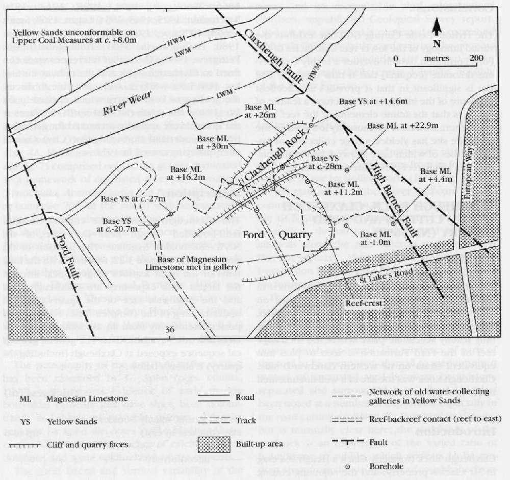
The Claxheugh exposures lie entirely within a fault-bounded trough near the core of the NNW–SSE Boldon Syncline. The position of the site is shown in
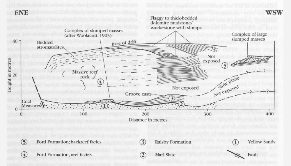
The relationships of the several stratigraphical units in the main faces are summarized in
| Thickness (m) | |
| Drift deposits, mainly boulder clay (thickest in east) | up to 6 |
| unconformity | |
| at least 55 | |
| 0–8 | |
| Marl Slate | 0.77–0.90 |
| Basal Permian (Yellow) Sands (about 18 m seen) | up to ?58 |
| unconformity | |
| Upper Coal Measures (Westphalian C) |
The ?early Permian aeolian Yellow Sands are almost at their thickest (about 58 m) beneath Claxheugh Rock; upper parts of the formation here were investigated in detail by Pryor (1971), who classified the weakly-cemented sand as a fine-to medium-grained subarkose with scattered to abundant coarse grains and large-scale, tangential trough cross-stratification. Pryor noted quartz and potassic feldspar contents of 88% and 8%, respectively, and determined a mixed cement of dolomite and calcite with a little illite.
Boreholes have shown that about half of the Yellow Sands at Claxheugh lie below river level. The formation is of special interest here because it was exploited for water by a local factory from which a complex system of galleries was driven south-eastwards deep into the hill along the local water table
The top of the Yellow Sands at the north-eastern end of the Claxheugh Rock section slopes steeply south-southeastwards (Trechmann, 1954) and boreholes in the quarry floor show that this slope continues for some distance and takes the reef/sand contact from about +26 m O.D. at outcrop at the north-east end of Claxheugh Rock to about +11 m only 150 m farther south, and to about −3 m O.D. in the south of the quarry
Marl Slate
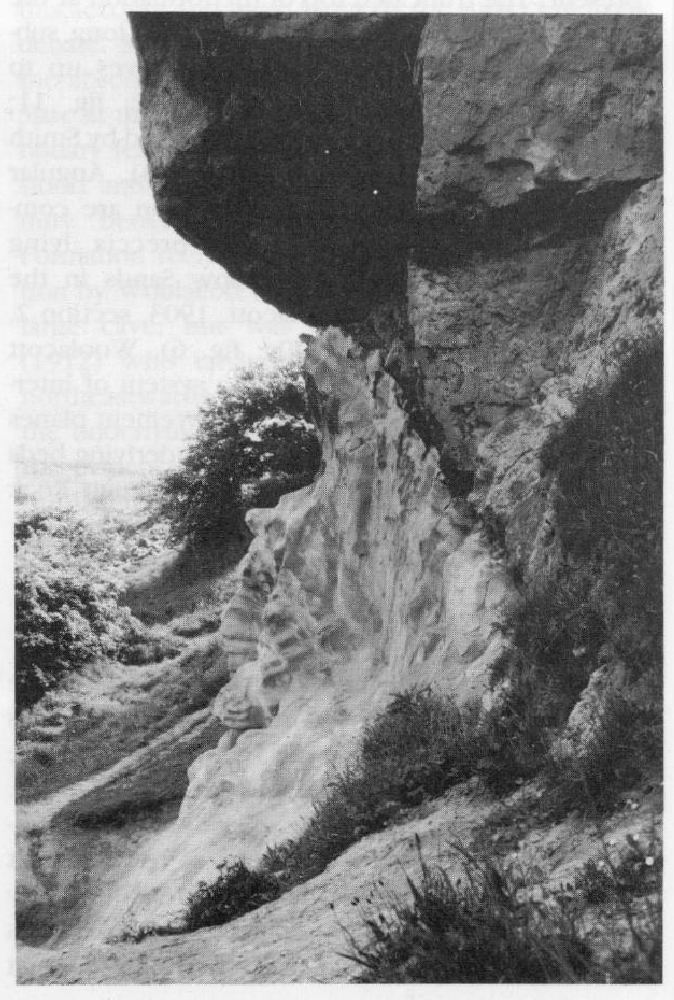
This comprises finely laminated, buff and grey, slightly carbonaceous, dolomitic shale with laminae, lenses and thin beds (some partly contorted) of brown, carbonaceous, plastic clay; scales of palaeoniscid fish are scattered sparingly, but whole fish are very uncommon. The bedding is locally minutely contorted and overfolded at some levels, with an ENE sense of movement, and some of the clay films extend along curved cracks (see below) down into the underlying Yellow Sands. T. Deans (pers. comm., 1959) records a carbonate content of 33O (mainly dolomite) and lead and zinc contents of 330 and 350 ppm, respectively in the Marl Slate here.
Raisby Formation
Flaggy- to medium-bedded (0.05–0.30 m) very finely crystalline dolomite of the
Ford Formation
This is the main marine stratigraphical unit in the Claxheugh–Ford Quarry complex, and comprises reef and backreef facies; the reef is slightly more than 200 m wide and comprises several sub-facies.
The backreef facies is exposed in the southwestern part of the quarry and of the adjacent cutting and comprises at least 55 m of buff, very finely crystalline dolomite in relatively even beds commonly 0.1–0.25 m thick. Only the uppermost 18–20 m of these beds are now visible, and dip gently towards the reef, but lower beds in the western parts of the north-west and south-east walls of the quarry were formerly seen dipping reefwards at up to 30° and to diverge in the same direction. All these backreef-rocks are diversified by the presence of large masses of discordant or crumpled strata (Trechmann, 1945, fig. 2; 1954, fig. 3; Smith, 1970a, fig. 17) interpreted by the writer as the product of submarine slumps. Kirkby (1867, p. 197) and Trechmann (1945, table 1 and plate XV) reported substantial lists of fossils (mainly brachiopods and bivalves) from the backreef strata in the cutting and quarry respectively, both workers believing that these beds formed part of the Lower Magnesian Limestone (=
The reef facies of the
The reef-core sub-facies comprises a great mass of buff and brown dolomitic bryozoan boundstone (framestone); it is essentially unbedded, but the reef in the 20 m high cliff of Claxheugh Rock features a number of major sub-concordant partings (Woolacott, 1914, fig. 1; Pettigrew, 1980, fig. 7). Most of the rock is finely crystalline, turbid dolomite in which, because of complex diagenesis, fossils are generally poorly preserved (Trechmann, 1945; Aplin, 1985; Hollingworth, 1987). Despite this, Pattison (unpublished Geological Survey report, 1969, and in Harwood et al., 1982, p. 21) recognized some 16 invertebrate species including several species each of bryozoans, brachiopods and bivalves. Trechmann (1931, 1954) commented that the earliest part of the usual reef sequence is missing at Claxheugh Rock, where the reef rests on a deeply scoured surface of
The reef-core and ?reef-flat dolomite boundstone in the cutting contains a number of vertical tension fissures up to 0.5 m across and 3 m deep (Aplin, 1985, pp. 90–94), that have not been recognized in the nearby quarry. Aplin reports that the fissures are lined with laminated dolomite of possible algal origin, and that some have cores filled with bioclastic debris; he infers from this fill that the fissures were opened whilst the reef was growing.
In the easternmost part of the cutting and quarry, the crudely bedded uppermost part of the reef-core is seen to increase in dip from almost horizontal to up to 50° (Smith, 1981a) as it passes through the reef crest into the uppermost part of the reef slope. The rock here is a crumbly, saccharoidal dolomite boundstone and comprises a highly varied mixture of in situ and detached masses of bryozoan boundstone (framestone), complexly anastomosing laminar ?algal sheets and cavity-fill, and pockets of shelly rubble that are locally rich in gastropods, the brachiopod Dielasma and the nautiloid Peripetoceras; most organisms in the rock are algal-encrusted, and encrustations probably comprise more than 70% of the whole. Many of the laminar sheets bear laterally-linked stromatolite hemispheres, and outward and upward-elongated columnar algal stromatolites up to 0.15 m high and 0.05 m across occur in places at least 5 m down-slope from the reef crest (Smith, 1981a, fig. 18).
Interpretation
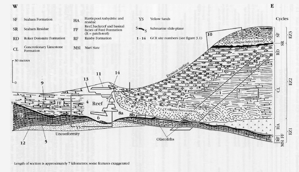
The complex of faces at Claxheugh Rock and in the adjoining cutting and quarry provide vital links in the chain of evidence favouring massive submarine slumping and sliding during Raisby and Ford formation times and also yield key evidence on the structure, shape and composition of the shelf-edge reef of the
Evidence bearing on submarine slumping and sliding
The unusual relationships of strata at the base of the Claxheugh Rock section have been commented on by most of the authors listed in the introduction to this account and were formerly the subject of lively debate. Most of the early authors recognized that the absence of the
Woolacott's (1903, Section 2) faithful recording of a particularly complicated part of the Claxheugh Rock section underlines the importance for geologists of making full records of what they see, even if they cannot interpret or understand it; the exposure was covered by debris from the 1905 landslip, but Woolacott's drawing and description were invaluable in the reinterpretation by Smith (1970c) of the history of the area late during
Ford Formation
Although advanced diagenesis has obscured many primary details of the shelf-edge reef of the
The shelf-edge reef is also a feature Of the GCR site at Hylton Castle to the north, and, to the south, of the sites at Humbledon Hill, Tunstall Hills (north and south), Stony Cut (Cold Hesledon), Hawthorn Quarry and Horden Quarry. Aspects of reef distribution, structure, fabric, biotas and diagenesis at these localities are discussed in the relevant accounts. The aspect for which the reef at Ford Quarry is especially noteworthy is that the northeast face is the best exposure of algal-dominated, nautiloid-rich reef crest and high reef slope dolomite and is the only reef exposure containing columnar stromatolites. The presence of large, rolled, detached blocks here is indicative of phases of high energy.
The exposure of the reef-backreef contact is important for a number of reasons. Firstly, it shows that the landward edge of the reef was sharp, with very little relief, proving that the reef surface was barely higher than the backreef sea floor and that backreef carbonates accumulated at the same rate as the reef grew upwards. Secondly, the virtual absence of reef debris in backreef beds implies little erosion and sediment transport landwards across the top of this part of the reef. Thirdly, the general verticality of the contact shows that the landward edge of the reef remained geographically static whilst the seaward margin prograded; the reef therefore became wider with time.
Finally, the exposed backreef strata themselves are unique in being composed of altered carbonate muds and in containing a fairly varied and abundant invertebrate fauna that includes bryozoans and brachiopods. All the other exposures of back-reef strata of this age in north-east England are predominantly of altered oolite grainstones with a sparse bivalve-gastropod fauna. The presence of reefwards-displaced allochthonous slide-blocks in these beds is also unique to Ford Quarry and the cutting, and shows that the backreef sea floor sloped towards the reef and was repeatedly unstable. The reasons for these various differences are not known, but Smith (1994) has speculated that they may have arisen because the reef here grew across the floor of a WSW/ENE submarine slide-canyon at least 30 m deep and the sea here may therefore have been deeper than in most other places.
Future research
Most aspects of the several formations exposed at this complex of exposures have been subject to detailed research in recent years and there seems little scope for further detailed studies in the immediate future; an exception is the backreef facies of the
Conclusions
This GCR site is the type section of the