Lyne Water and Lynslie Burn
David J. Siveter
Introduction
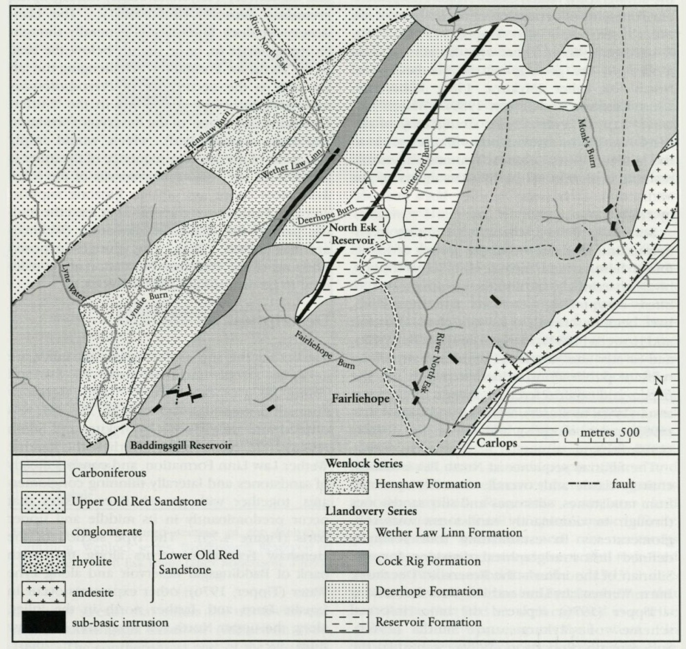
This site is within the SSSI named Baddingsgill Reservoir and is situated in the south-western part of the North Esk Inlier
Notes on the geology of the Pentland Hills were published as early as 1839, in MacLaren's account of Fife and the Lothians. The area was subsequently mapped by the Geological Survey — first by Howell and Geikie (1861) then, most notably, as a part of Peach and Horne's classic study on the Silurian rocks of Scotland (1899), and more recently by Mykura and Smith (1962). Members of the Edinburgh Geological Society have also made important contributions to unravelling the geology of the North Esk Inlier (e.g. Haswell, 1865; Brown and Henderson, 1867; Henderson and Brown, 1870). In modern times detailed collecting and high resolution mapping has produced a much clearer picture of the stratigraphy, faunal assemblages and palaeoenvironments of deposition of the Silurian of the inlier (see especially Tipper, 1975, 1976; Robertson, 1989). There are also several field guides on the geology of the Pentlands and North Esk Inlier (Mykura, 1986; Robertson, 1986; Clarkson and Taylor, 1989). Walton and Oliver (1991) reviewed the stratigraphy of the Pentlands in context with other Silurian areas in the Midland Valley. The early to mid-Palaeozoic tectonic evolution of the Silurian inliers of the Midland Valley has very recently been analysed by Phillips et al. (1998).
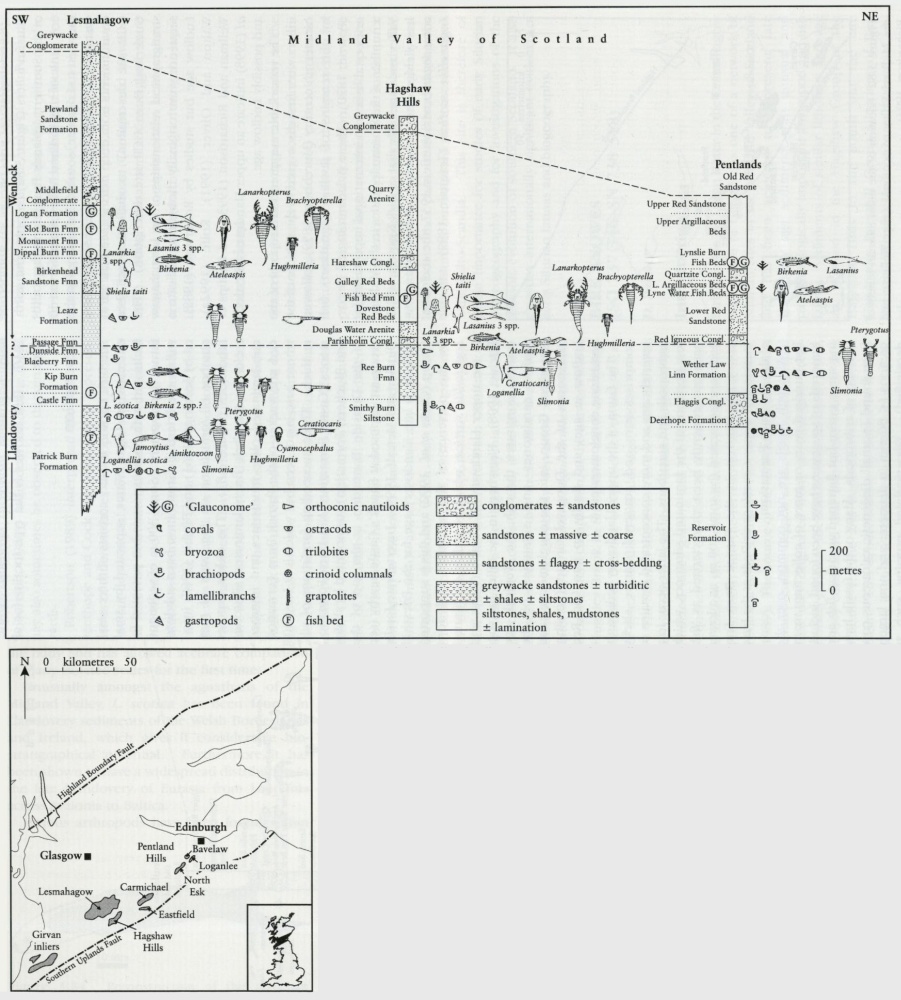
Several localities in the inlier are richly fossiliferous and many of the major groups of fossils found here, which include fish, brachiopods, bivalves, crinoids, echinoids, graptolites, trilobites, eurypterids, ostracods and microflora, have been described, at least in part. Clarkson and Howells (1981), Clarkson and Taylor (1989), and Siveter and Vannier (1990) list many of the relevant publications, added to which are the papers and other references therein of Clarkson et al. (1995; molluscs), Wellman and Richardson (1993; palynomorphs) and Märss and Ritchie (1998; fish).
The Silurian sequence at North Esk is almost entirely elastic and, overall, coarsens upwards, from mudstones, siltstones and silty sandstones through to dominantly sandstones and conglomerates. In establishing four formally defined lithostratigraphical divisions for the Silurian of the inlier — the Reservoir, Deerhope Burn, Wether Law Linn and Henshaw formations — Tipper (1976) replaced the more informal scheme of Mykura and Smith (1962). Subsequently, Robertson (1989) established the Cog Rig Formation in between the Deerhope and Wether Law Linn formations and divided the last of these into three members.
The exact age of the Silurian rocks of the Inlier has generated much debate, with many early authors maintaining that not only Wenlock but also Ludlow and possibly 'Downtonian' rocks are represented (e.g. Henderson and Brown, 1870; Peach and Horne, 1899). Lamont made valuable contributions (though often published privately) to our understanding of the stratigraphy and palaeontology of the North Esk Inlier. It was he (1947a, b) who first demonstrated the currently held view that the Silurian deposits here are largely of Llandovery age. The four oldest Silurian formations contain graptolites, assigned with various degrees of certainty to the late Llandovery (Telychian Stage) Monograptus crenulata Biozone (Bull, 1987). The Llandovery–Wenlock boundary is generally thought to approximate to, or lie slightly below, the base of the
Description
The beds at this site, as throughout the inlier, are generally steeply inclined, strike NE–SW and young to the north-west. The
Fossiliferous siltstones of the Upper Member of the
Exposures in the lower reaches of Lyne water, below its junction with Lynslie Burn, also show the virtually unfossiliferous red sandstones and mud-flake conglomerates that overlie the Igneous Conglomerate. The sandstones are micaceous, ripple-marked and contain desiccation cracks.
The
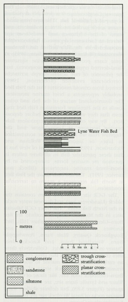
Above the red sandstones in Lyne Water, finer-grained sediments — olive, grey and reddish-brown shales and siltstones and fine sandstones — characteristic of the middle part of the
The red, trough cross-bedded sandstones that overlie the Fish Bed are well exposed in a strike section farther upstream in Lyne water. In Lynslie Burn, just above its junction with Lyne Water, there is another outcrop of the Fish Bed (Robertson, 1986, 1989). Some authors (e.g. Peach and Horne, 1899; Mykura and Smith, 1962) have regarded this as a separate fish-bearing horizon (the Lynslie Burn Fish Bed; see discussion in Märss and Ritchie, 1998). In the upper part of Lyne Water, above its junction with Lynslie Burn, the youngest exposed beds of the
Interpretation
The Silurian of the North Esk Inlier is generally accepted to have accumulated in one of a series of linear Silurian sedimentary sub-basins in the southern part of the Midland Valley, with land areas at times probably to the north and south. These sub-basins, which were possibly connected at various times, also encompass the Silurian deposits of the Hagshaw Hills, Carmichael, Lesmahagow Hills and the Girvan area and may have continued into Northern Ireland (e.g. Pomeroy and Charlestown areas) and south-west to County Mayo. In broad terms, the southern Midland Valley Scottish inliers show a history of early Silurian regression, in which distal turbidites are succeeded by a variety of shallow marine, mostly clastic sediments and, finally, terrestrial (alluvial) deposits. However, the particular tectonic setting of these sub-basins of deposition, on the southern margin of the Laurentian continent (see Pickering et al., 1988; Pickering and Smith, 1995; Phillips et al., 1998), has provoked much discussion. Leggett (e.g. 1987) envisaged that these Silurian sediments formed in an upper slope basin of deposition to the north of an emergent accretionary prism (Southern Uplands of Scotland) and associated northerly dipping subduction zone. Bluck (1984) considered that the Silurian deposits of the Midland Valley accumulated in inter-arc basins sourced mainly from the south-east. The various tectonic models are discussed by Phillips et al. (1998), who demonstrated that within the Midland Valley Terrane sinistral strike-slip controlled basin development, sedimentary facies distribution, and deformation from Ordovician through to, at least, early Devonian times.
The predominantly red-coloured and mostly unfossiliferous
The GCR site Gutterford Burn contains the oldest (Llandovery age) and deepest water rocks in the North Esk Inlier. The other GCR Silurian sites in the Midland Valley of Scotland are Ree Burn–Glenbuck Loch in the Hagshaw Hills, Birk Knowes of the Lesmahagow Inlier, and Roughneck Quarry, Blair Farm, Penwhapple Burn, Woodland Point, and Knockgardner Quarry in the Girvan district. Collectively these sites comprise a network that gives evidence of an early to mid-Silurian marine to non-marine transition. The Wenlock strata of the Ree Burn–Glenbuck Loch site, like those of the Lyne Water and Lynslie Burn site, are essentially non-marine
Conclusions
This is an internationally known site from which fossils have been collected for more than a century. It provides the type section for the youngest Silurian lithostratigraphical unit, the Renshaw Formation (Wenlock Series), in the North Esk Inlier. It has early vertebrate faunas and also microfloras that, together with its sedimentary facies, outline the palaeoenvironmental conditions typical of the Midland Valley sedimentary basin(s), to the north of the remnant Iapetus Ocean, during early Silurian times. Evidence from the site endorses the notion that parts of this northern margin of the Iapetus Ocean witnessed the onset of non-marine conditions very early in the Silurian compared to other British Silurian basins. The sporomorph (plant microfossil) assemblages found here (and in the younger horizons of other Midland Valley Silurian inliers) are of much palaeobotanical significance, because they represent globally rare, early, lower Silurian occurrences of presumed continentally-derived forms.