Flamborough Head, north and east Yorkshire
Introduction
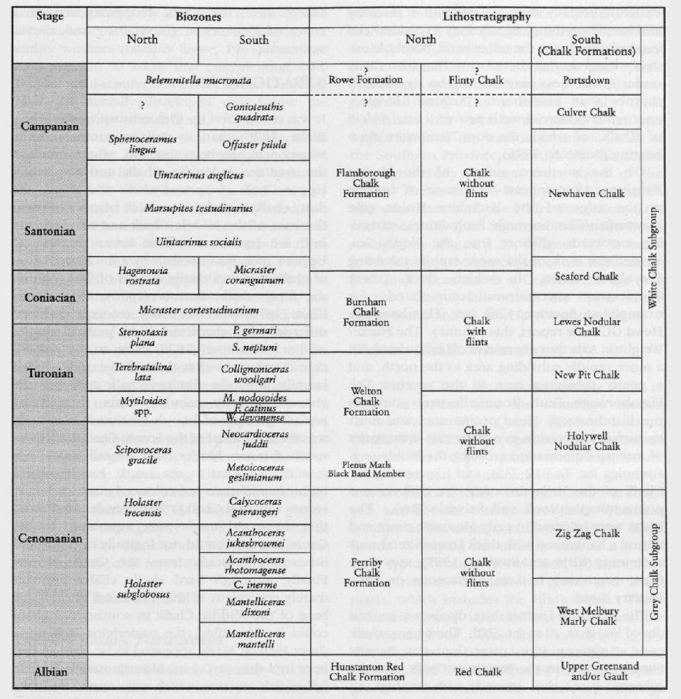
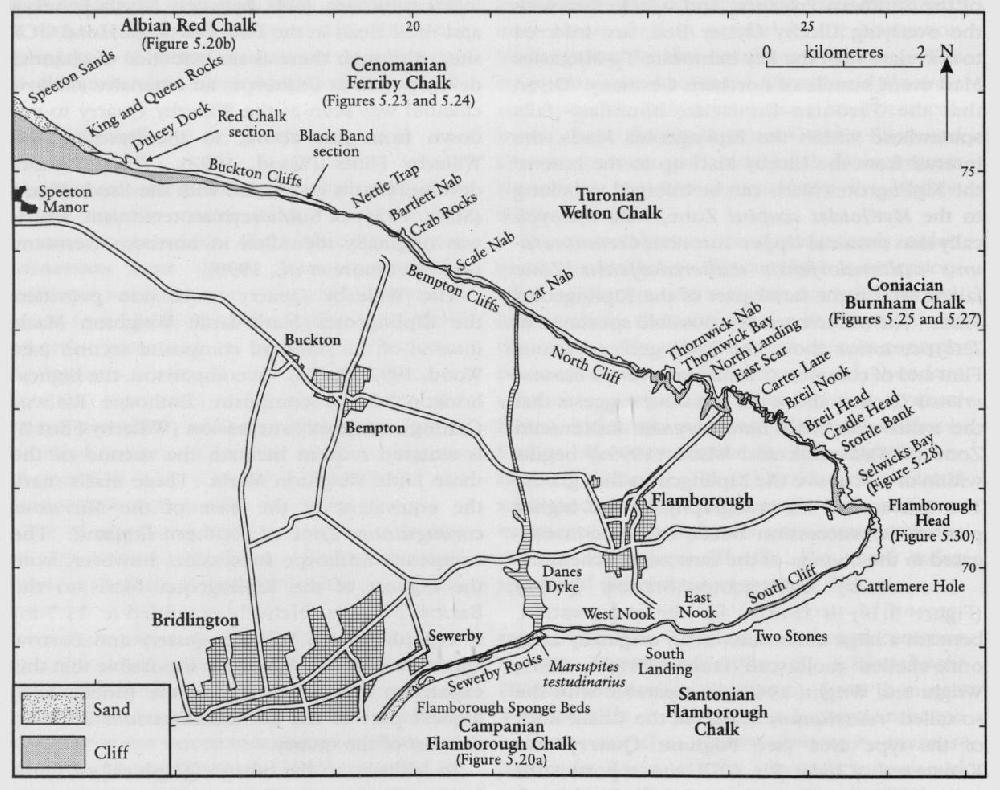
The Flamborough Head GCR site comprises 17 km of sea cliff and rock platform sections on the north Yorkshire coast. These cliffs expose a continuous Northern Province Chalk succession from the base of the Upper Cretaceous Series, in the Hunstanton Red Chalk Formation at Speeton Cliff; up to the lower part of the Lower Campanian succession, at the top of the preserved
At Speeton Cliff, there is an expanded, and possibly the most complete section in the UK across the Albian–Cenomanian boundary, here in red chalk facies. The coastal cliffs from the eastern end of Buckton Cliffs to Selwicks Bay provide the only available (albeit largely inaccessible) continuous section from the base of the
Description
An amazingly perceptive review of the Yorkshire Chalk stratigraphy in general — but with particular reference to the Flamborough promontory — was undertaken on the basis of a brief visit by the Frenchman, Charles Barrois (1876). He was the first stratigrapher to attempt to understand the succession here in terms of the macrofossil zones that he and his collaborators had established in the Chalk of the Paris Basin. A few years later, an important sequence of papers, including measured sections of the highest Burnham Chalk and the overlying Flamborough Chalk, as well as photographs of the cliff sections and discussion of the fault zones, was published by Lamplugh (1880, 1894, 1895, 1896).
Detailed descriptions of the stratigraphy of the post-Cenomanian ('White Chalk') sections, supplemented by annotated photographs, were given by Rowe (1904) when he, following his work in southern England, fulfilled his (p. 194) 'long-cherished furtive ambition to explore this mysterious and legendary coast'. He came away deeply impressed by its grandeur (p. 196)… we have no counterpart in the South of the grand screes of Speeton Cliff nor are our southern cliffs, however lofty, comparable to the mighty tide-bound ramparts of Bempton'. He emphasized the physical difficulties of working on the cliff sections. However, although he commented on the poor preservation and sparse nature of the fossils, he managed to collect an amazing amount of material from sections that today are extremely unproductive. Because the faunas of the equivalent of the Micraster coranguinum Zone and the (then) Actinocamax quadratus Zone are significantly different from those in the Southern Province, Rowe introduced two local replacement zones, the Infulaster rostratus and Inoceramus lingua zones respectively. He also provided notes on the lithology and faunas of 32 pits and quarries near Flamborough and on top of the Wolds west of Bridlington. Most of these sections are no longer extant, and his observations are therefore of great value. His field companion, Charles Sherborn (see frontispiece photographs), additionally supplied a geological map of the area, with the inferred positions of the zonal boundaries, as well as interpretative longitudinal sections both of the cliffs themselves, and of the relationship between the cliffs and the inland pits. Rowe's essentially biostratigraphical investigation, although carried out at the beginning of the 20th century, is remarkably informative, and is still indispensable for anybody who wants to examine this site.
After this period, the only significant contribution to the study of the Yorkshire Chalk was a comprehensive review of the stratigraphy and faunas of the inland sections (Wright and Wright, 1942). In this key paper, the Uintacrinus socialis and Marsupites testudinarius zones were given formal zonal status in Britain for the first time, and the Subzone of Discoscaphites binodosus was introduced for the highest part of the flintless (Flamborough) chalk succession. Neale (1976) gave a tabular revision of the Upper Cretaceous stratigraphy, and provided a longitudinal section, but neither the table nor the section includes any new information. In the context of developing a mapping stratigraphy of the Chalk for the British Geological Survey, Wood and Smith (1978, fig. 5) correlated the highest Welton Chalk and basal Burnham Chalk succession in North Landing with inland sections in Yorkshire and Lincolnshire. Whitham (1991) published measured sections of the accessible parts of the Welton Chalk and Burnham Chalk in North Landing and Thornwick Bay, extending the Wood and Smith section down to the
For descriptive purposes these 17 km of cliffs are divided into four parts and are treated separately:
Part 1 includes Speeton Cliff–Buckton Cliffs. This magnificent section through the Hunstanton Red Chalk Formation and
Part 2 comprises the vertical cliffs and scars (rock platforms) from Speeton Cliff and Buckton Cliffs eastwards to Stottle Bank in the Welton Chalk and Burnham Chalk formations. These cliffs include the Royal Society for the Protection of Birds (RSPB) bird reserve at Bempton Cliff, and the structurally complex area known as 'Staple Nook' or 'Scale Nab', which are inaccessible. However, it is possible, but with great difficulty, to walk at extreme low water along the boulder-strewn beach at the foot of the cliffs from Speeton Cliff as far as Staple Nook (adjacent to Scale Nab). Beyond Staple Nook the remainder of the traverse through Sanwick Bay (Rowe, 1904, pl. 27) is prevented by deep-water caves and inlets. The first access to the shore is at Little Thornwick Bay. Here, and in the adjoining Great Thornwick Bay and North Landing, there are excellent sections in the cliffs and scars of the composite succession from the
Part 3 includes the highest part of the Burnham Chalk which is exposed between Stottle Bank, where the cliff-line changes from NW–SE to north–south, and Selwicks Bay, where basal (flintless)
Part 4 comprises the highest
Part 1: Speeton Cliff–Buckton Cliffs
1.1: Hunstanton Red Chalk Formation (Speeton Cliff)
Speeton Cliff; at the southern margin of the Cleveland Basin, provides a continuous, albeit intermittent, exposure in the sea cliff and shore platform of an expanded succession across the boundary between the Lower and Upper Cretaceous series. In contrast to the condensed successions on the East Midlands Shelf and Market Weighton Axis, the succession here is unbroken by a hiatus, and the boundary falls within the Hunstanton Red Chalk Formation, rather than at the base of the (redefined)
Lithostratigraphy
The succession
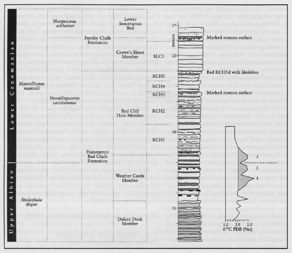
Mitchell (1995a) gave a comprehensive historical review of the usage of the stratigraphical term 'Red Chalk'. He assigned the Red Chalk formally to the Hunstanton Red Chalk Formation and divided the succession at Speeton Cliff into five members, which he described and illustrated in detail. He also reviewed previous work on the Albian–Cenomanian stratigraphy at Speeton Cliff, and provided a correlation table to show the nomenclature of the various units adopted by previous workers.
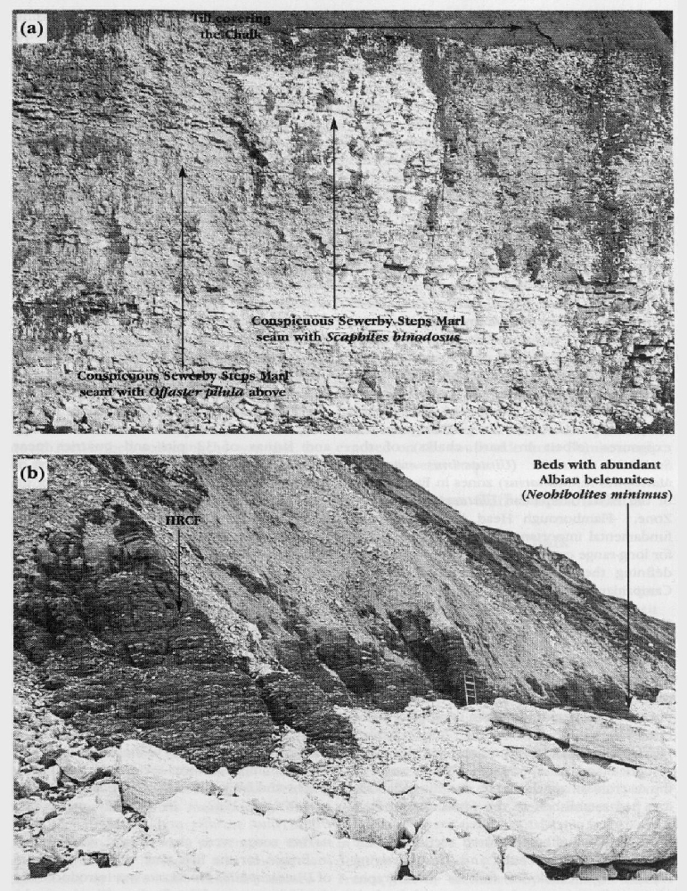
Speeton Cliff provides a continuous expanded basinal succession across the Albian–Cenomanian boundary (see details below). The actual boundary falls within the
1.2: Ferriby Chalk Formation (Speeton Cliff–Buckton Cliffs)
The lower part of the
Part of the
Biostratigraphy
Speeton Cliff is critical to the international correlation of the Albian–Cenomanian boundary because of the apparent unbroken sedimentary record across this interval (see below). Inoceramid bivalves belonging to the group of Inoceramus anglicus Woods range through the higher part of the
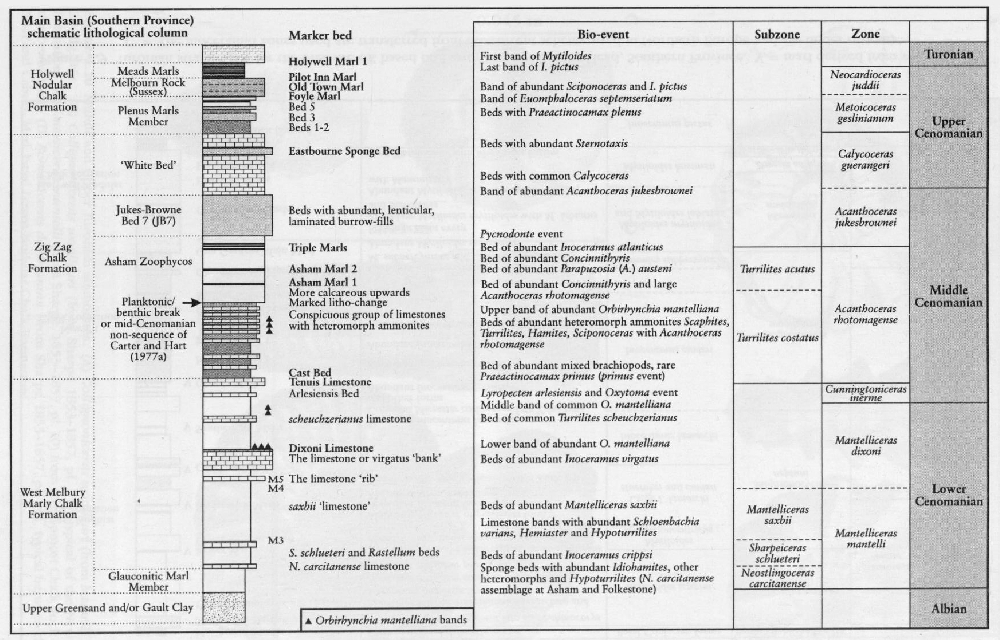
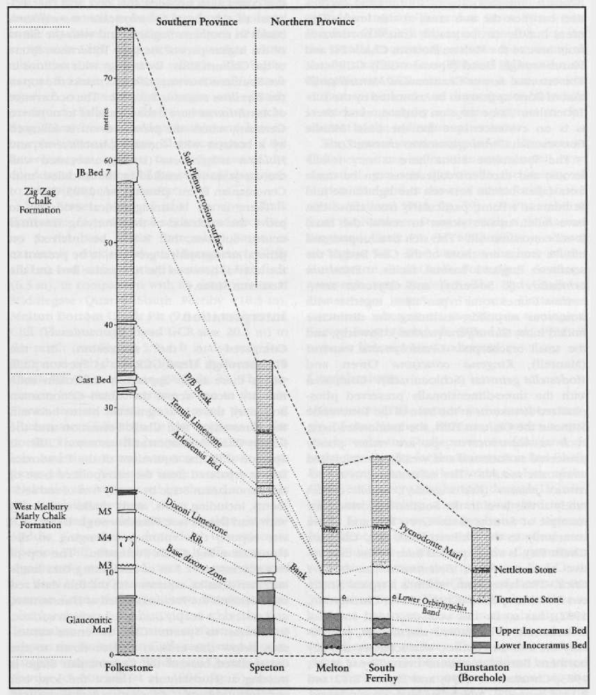
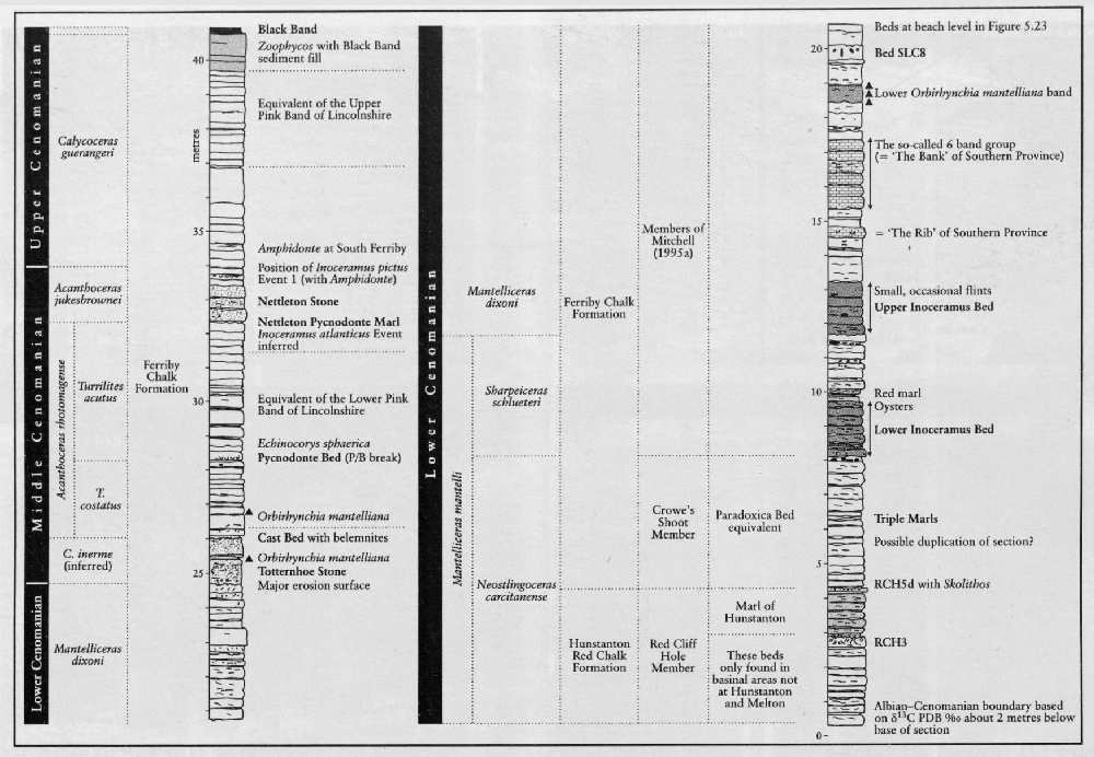
The reappearance of inoceramid bivalve shell debris in the Upper Inoceramus Bed has been inferred (Mitchell et al., 1996) to correspond to the transgressive sediments at the base of the Mantelliceras dixoni Zone. This assignment is supported by the occurrence of Inoceramus ex gr. virgatus Schlüter in a conspicuous group of six pale limestones (the '6 Band Group' of Jeans, 1980; SLC6A–F of Mitchell, 1996). This equates with the Inoceramus virgatusacme that is found throughout northern Europe in a group of noticeably more calcareous beds (marker horizon A of Mitchell et al., 1996) in the lower part of the dixoni Zone; the highest of these limestones has yielded a single specimen of Mantelliceras dixoni Spath. These limestones are followed by a unit of marly chalk containing the rhynchonellid brachiopod Orbirhynchia mantelliana (J. de C. Sowerby). This marker event (B of Mitchell et al., 1996), called by Jeans (1980) the 'Lower Orbirhynchia Band', correlates with the lowest of the three mantelliana bands of the Southern Province (
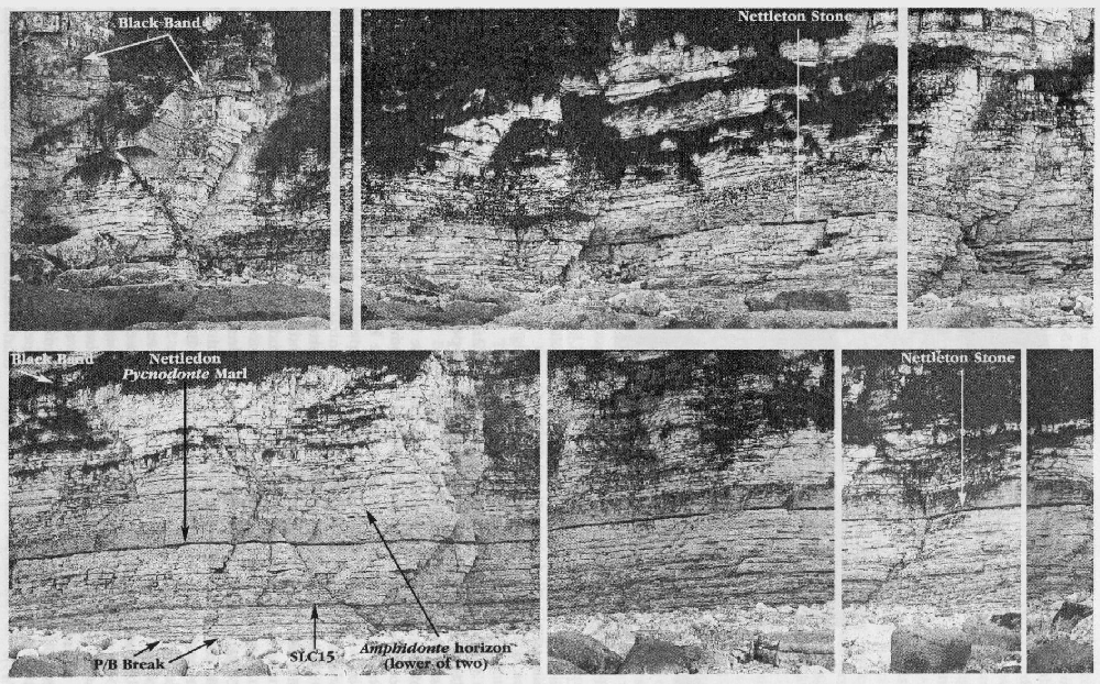
The Middle Cenomanian section is situated about 100 m beyond the large fallen mass of Middle Turonian cliff (Weather Castle,
The critical stratigraphy and correlation of the lower part of the Middle Cenomanian Substage at Speeton Cliff has been discussed in detail (Paul et al., 1994; Mitchell et al., 1996; Mitchell and Carr, 1998). The Totternhoe Stone here rests on a burrowed chalk, rather than on a well-developed erosion surface, as in the case of the condensed successions on the Market Weighton
Axis and the East Midlands Shelf. The Totternhoe Stone itself is complex, comprising silty marls, passing up into calcarenitic chalks and then into normal chalks. Its base lies below the base shown by Mitchell. This succession consists of the condensed components of four marl-limestone couplets (B41–43; C1) of the standard Cenomanian cyclostratigraphy established by Gale (1995). The main calcarenitic part of the Totternhoe Stone largely consists of couplet 42 of Gale.
The position of the Arlesiensis Bed (marker E and the marl of Couplet B41 of Gale (1996)) of the Southern Province (e.g. Southerham Grey Pit and Folkestone to Kingsdown. GCR sites), can be inferred from the position of the lower (MCE1a) of the pair of Middle Cenomanian positive δ13C excursions recognized throughout northern Europe by Mitchell et al. (1996). This 10 cm-thick silty marl has yielded specimens of (Paul et al., 1994, fig. 11) the diagnostic lower Middle Cenomanian inoceramid bivalve index species, Inoceramus schoendorfi Heinz, and a single specimen of the rhynchonellid brachiopod Orbirhynchia mantelliana, but not the eponymous Lyropecten (Aequipecten) arlesiensis (Woods).
The equivalent of the
Orbirhynchia mantelliana is restricted here to a single couplet (C4), compared with its greater range in the Southern Province, for example couplets C6–C11 at Southerham Grey Pit, constituting the highest of the three Orbirhynchia mantelliana bands. The so-called P(lanktonic)/B(enthic) break (marker horizon G), which is marked by a sudden increase in planktonic foraminifera as a percentage of the total foraminiferal assemblage, falls here at the base of a thick marl seam (SLC13), which weathers back in the cliff.
Jukes-Browne Bed 7 of the Southern Province successions is represented here by the 1 m-thick calcarenitic
The succession from the top of the
The Albian–Cenomanian boundary and division of the Cenomanian Stage
At Speeton Cliff, in an apparently unbroken sedimentary record across the Albian–Cenomanian boundary, the base of the Cenomanian Stage can be exactly located. The boundary is drawn through the trough between the top two of a well-marked triplet of closely spaced positive 813C peaks
The extrapolated base of the Cenomanian Stage lies approximately 0.5 m beneath the top of the
The Lower–Middle Cenomanian boundary transition is also more complete at Speeton Cliff than in the platform successions to the south, for example Melton Bottom Chalk Pit on the Market Weighton Axis, and the Middlegate Quarry, South Ferriby, on the East Midlands Shelf At the latter localities, the equivalent of the basal Middle Cenomanian Cunningtoniceras inerme ammonite Zone of the Southern Province is completely missing at the hiatus marked by the sub-Totternhoe Stone erosion surface (cf. Mitchell, et al., 1996, fig. 3).
Part 2: Welton Chalk and Burnham Chalk formations (Buckton Cliffs to Stottle Bank)
At the eastern end of Buckton Cliffs, the dip brings the boundary between the Ferriby Chalk and Welton Chalk formations down to sea level, close to a wave-washed point known as 'Kit Pape's Spot'
Sherborn's longitudinal cliff section (Rowe, 1904, pl. 38) showed that chalk with tabular flints (identified as the Holaster planus Zone) occupied the higher part of the cliffs between the eastern end of Buckton Cliffs and a point, Gull Nook
This suggests, on the basis of data from outcrop and subcrop successions (cf. Wood, 1992, fig. 34; Berridge and Pattison, 1994, fig. 19) that the topmost beds in the 90–100 m high cliffs to the north-west of the nature reserve may actually lie close to the top of the Micraster cortestudinarium Zone. A thin capping of the post-
2.1: The Staple Nook (adjacent to Scale Nab) zone of deformation
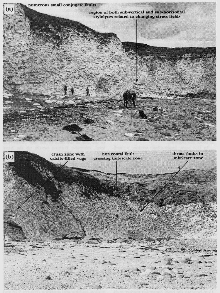
In an embayment known as 'Staple Nook' (Newk), at the south-east end of Bempton Cliffs, the Welton Chalk strata, which dip at 10°–15° to the south, are interrupted by a narrow zone, 200 m wide
Starmer (1995b) gave a modern structural interpretation based solely on the photographs, and related the deformation to late-stage reactivation of the underlying deep-seated Bempton Fault, which had been previously recognized by Kirby and Swallow (1987) in seismic profiles. Oblique aerial photographs show that the structurally simple Old Dor fold comprises only the more massively bedded
2.2: Little Thornwick Bay–Great Thornwick Bay–North Landing
Annotated photographs (Rawson and Whitham, 1992a, fig. 33) of the cliff sections in Little Thornwick Bay, and photographs of the cliffs in Chatterthrow
Lithostratigraphy
The
In the latter bay, the
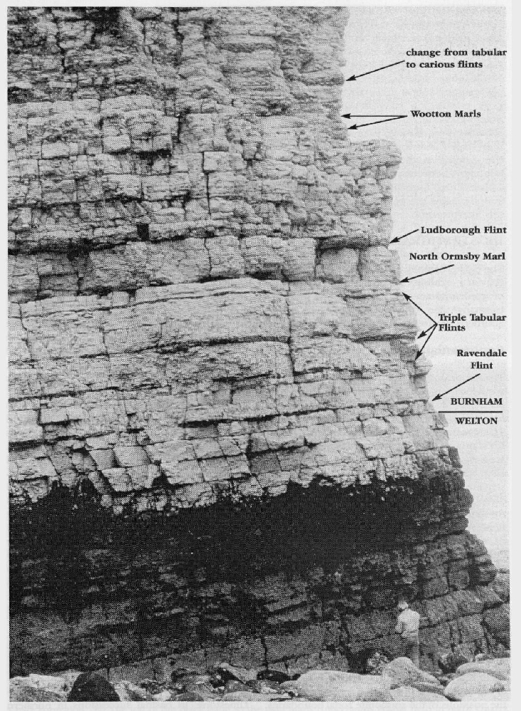
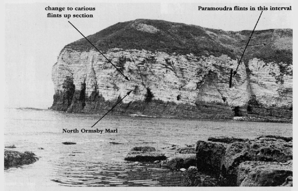
Mortimer (1878) first drew attention to the vertical columns of flint (paramoudras) at the base of the cliffs on the east side of the bay. Rowe (1904) stated that six such flints could be seen from the sea to the south-east of North Landing, noting that they characterized a level in the upper part of his Holaster planus Zone. It is now known that paramoudras are relatively common everywhere in the Sternotaxis plana Zone at this level, i.e. in the interval with closely spaced thick tabular flints between the
Biostratigraphy
Barrois (1876) was the first geologist (28 years earlier than Rowe) to use fossils to subdivide this composite section into zones. His pioneering work was remarkably correct by today's standards. He recognized that the chalk in Little and Great Thornwick Bay must belong to the Terebratulina gracilis (i.e. lata) Zone because of the general rarity of macrofossils, apart from the inoceramid bivalve Inoceramus brongniarti (i.e. I. ex gr. lamarcki Parkinson). Even more importantly, he appreciated that the 'very hard, siliceous, crystalline chalk' in North Landing, with 'closely-spaced, smokey-grey, predominantly tabular flints' (his 'Chalk with grey flints of North Sea') contained fossils indicative of the Holaster planus Zone, including the zonal index fossil. Rowe (1904) actually recorded 30 examples of Sternotaxis plana from here, noting that it was 'common'. It is surprising that there are no records of Micraster, since M. corbovis Forbes occurs regularly at this level in inland pits in Yorkshire and in Lincolnshire. Barrois noted this same distinctive flinty unit (i.e. basal
2.3: North Landing–Stottle Bank
From the eastern headland of North Landing, for 1.8 km to Stottle Bank, 0.5 km north of Selwicks Bay, there is no access to the shore, although it is feasible, if extremely dangerous, to land from a boat at low water on the scars that extend out some distance from the cliffs near the headland known as 'Breil Nook' on modern maps
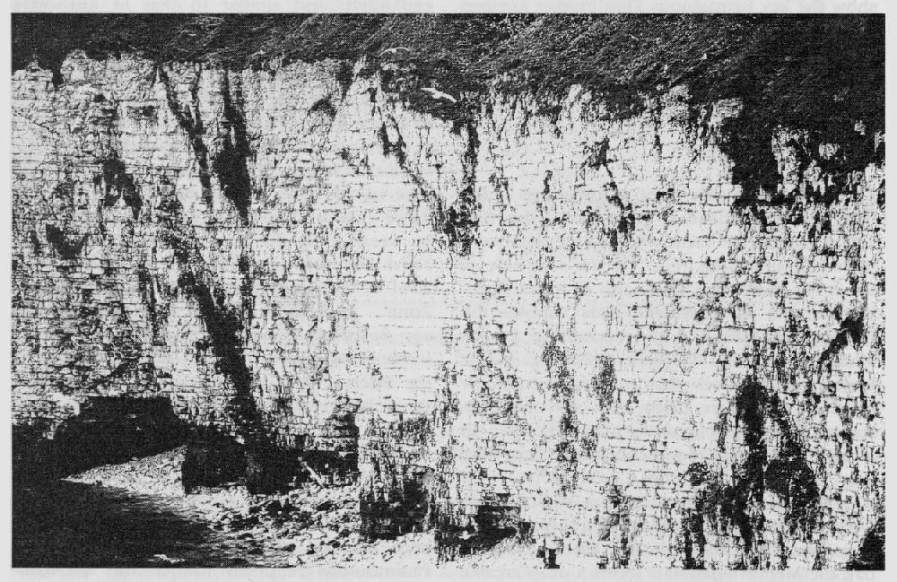
Inspection of a set of oblique aerial photographs of this coastal stretch, in conjunction with telephoto photographs taken from the top of the cliffs, and photographs of the cliff section on the east side of North Landing, suggests that it may be possible to begin to interpret the stratigraphy. The
In this same longitudinal section, a 'well-marked line of holes' was used to indicate the approximate boundary between the Micraster cortestudinarium and M. coranguinum zones. This marker horizon was said to be traceable from a little east of Breil Nook, where it appeared in the top of the cliff below the drift (Rowe, 1904, pls 29, 38), to a point just south of Stottle Bank, where it reached sea level. It is actually improbable that this 'line of holes' is at or even near the base of the coranguinum Zone, since there is no evidence at Stottle Bank of the common thick-shelled inoceramid bivalves (Volviceramus and Platyceramus) that characterize the basal 15 m of this zone in inland sections (see Whitham, 1991; Wood, 1992). In view of the fact that another 'line of holes' (i.e. karst development over a marl seam) at Stottle Bank marks the approximate position of the base of the Santonian portion of the coranguinum Zone (see below), it is more likely that Rowe and Sherborn's marker is the Middleton Marl (i.e. near the top of the Coniacian portion of the zone), or that the latter marl is represented by the deep crevice, seen 13 m beneath the basal Santonian marker marl, at the base of the deep water gully at Stottle Bank itself. This latter interpretation fits with the record of Cladoceramus in NIREX Borehole 37 in north Lincolnshire, 12 m above the Middleton Marl.
Part 3: Stottle Bank–Selwicks Bay–Flamborough Head (High Stacks)
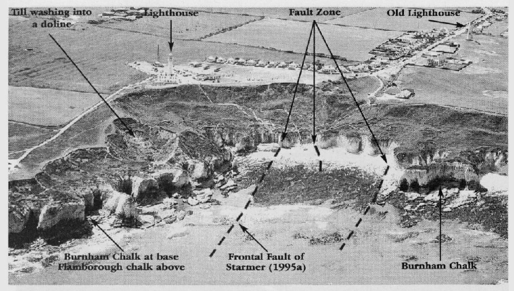
Stottle Bank to Flamborough Head crosses the complex tectonic structures related to faulting in Selwicks Bay
Lithostratigraphy and tectonic structures
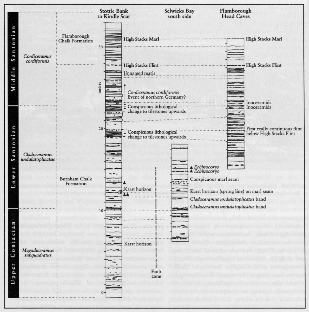
The previously unpublished c. 30 m section
The early workers (e.g. Lamplugh, 1880, 1895), presented a relatively simple structural picture of Selwicks Bay, in which flintless (i.e.
In
Thin, poorly developed white flints are found in the Selwicks Bay section in the basal
Biostratigraphy
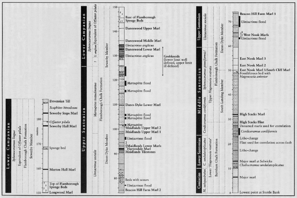
The biostratigraphy of the highest Burnham Chalk in these sections is extremely poorly known. Professor A.S. Gale (unpublished data) has collected specimens of the thin-shelled inoceramid bivalve Cladoceramus undulatoplicatus (Roemer) (now at the British Geological Survey, Keyworth) at two horizons beneath the unnamed marl seam on the south side of Selwicks Bay, allowing this part of the succession to be assigned to the basal Santonian Cladoceramus undulatoplicatus Zone of the standard European zonal scheme. About 1 m above the highest occurrence of Cladoceramus, he collected specimens of the echinoid Infulaster infulasteroides (Wright and Wright) (common over 1 m), terebratulid brachiopods (Gibbithyris sp.) and other inoceramid bivalves that are possibly Sphenoceramus cardissoides (Goldfuss). About 10 m above the marl, in the section immediately north of Kindle Scar, the occurrence of Cordiceramus cordiformis (J. de C. Sowerby) (British Geological Survey collections, unpublished) in fossiliferous, inoceramid bivalve-rich chalk over about 4 m suggests a correlation with the Cordiceramusacme in the Middle Santonian strata of northern Germany (Ernst, 1966; Ernst and Schulz, 1974), and indicates a possible upper limit to the Lower Santonian succession. This would fall in the higher part of the coranguinum Zone of the Southern Province. It is not possible at present to identify the Burnham–Flamborough boundary on a faunal basis. However, since it is known that the base of the Uintacrinus socialis Zone is situated 70 m above the High Stacks Flint, it is clear that the higher part of the equivalent of the coranguinum Zone, both the flinty (Burnham) and flintless (Flamborough) components, is enormously expanded here compared to its development in the Southern Province (about 87 m compared with 32 m from the base of the Santonian to Buckle Marl 1 at Seaford Head (Cuckmere to Seaford GCR site),
Part 4: Flamborough Head (High Stacks) [TA 257 704] to Sewerby Steps [TA 205 687]
The coast section from Flamborough Head (High Stacks) to Sewerby Steps can be divided into three separate parts by the structurally controlled inlets of South Landing and Danes Dyke, which provide the only access to the shore between High Stacks and Sewerby Steps. Excellent descriptions were given by Rowe (1904), Rawson and Whitham (1992b), Whitham (1992a,b, 1993) and Mitchell (1995b).
Lithostratigraphy
The composite lithostratigraphical section
Biostratigraphy
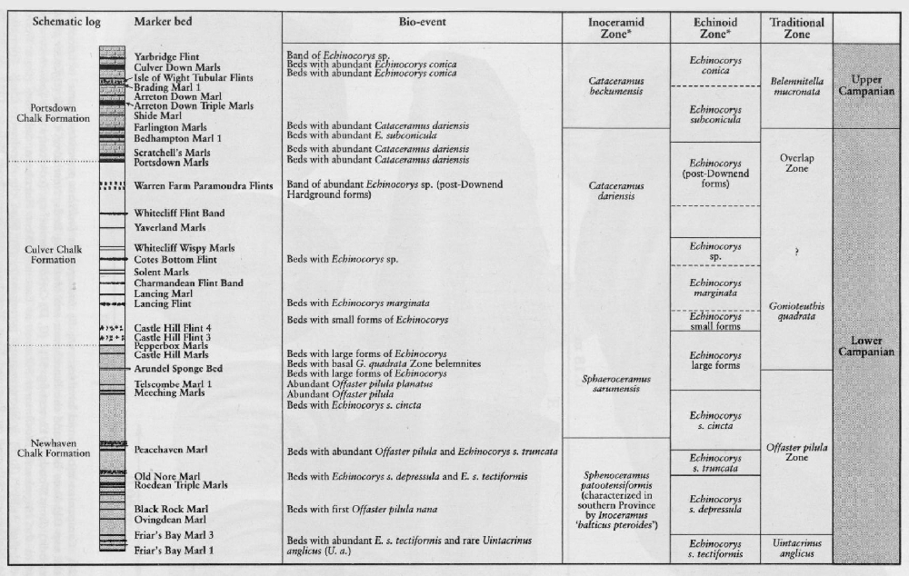
The Flamborough Chalk of the coast section extends from a horizon within the equivalent of the Middle Santonian part of the Micraster coranguinum Zone of southern England to low in the equivalent of the (Lower Campanian) Offaster pilula Zone. The entire equivalent of the M. coranguinum Zone, which spans the terminal Burnham Chalk and the basal Flamborough Chalk, was placed by Rowe (1904) in the local zone of Infulaster rostratus. This was based on the misunderstanding that, in view of the extreme rarity of the southern zonal index fossil, the flood occurrences, in the lower part of the Flamborough Chalk, of Hagenowia anterior Ernst and Schulz (mistakenly identified by him and later workers as Infulaster rostratus Forbes) could be used to characterize both the flinty (Burnham) and flintless (Flamborough) parts of the zone.
Little information is available on the biostratigraphy of the equivalent of the higher part of the Micraster coranguinum Zone. In the lower beds, there are few fossils, apart from sporadic occurrences of thin-shelled inoceramid bivalves and oysters, belemnites (Gonioteuthis), and sponges poorly preserved in limonite. Rowe (1904) recorded an 'almost obliterated ammonite, about 4 inches in diameter, from the base of the flintless chalk at High Stacks'. Some 20 m above the High Stacks Flint, a highly fossiliferous 1.5 m bed of chalk (first recognized by Lamplugh, 1895), containing abundant specimens of Hagenowia anterior, together with the small spherical calcareous sponge Porosphaera globularis (Phillips), can be traced in the lower part of the cliff for over 2 km. Whitham (1993) additionally recorded specimens of Gonioteuthis westfalica (Schlüter), the small rhynchonellid brachiopod Orbirhynthia pisiformis Pettitt, small corals and echinoid spines from this bed and, at an unspecified level near South Landing, both he and Rowe (1904) noted large ammonites tentatively assigned to Parapuzosia (P.) leptophylla (Sharpe).
In the highest part of the pre-Uintacrinus socialis Zone Flamborough Chalk succession, small crinoid plates and columnals attributed to the comatulid crinoid Amphorometra are not uncommon (Mitchell, 1994).
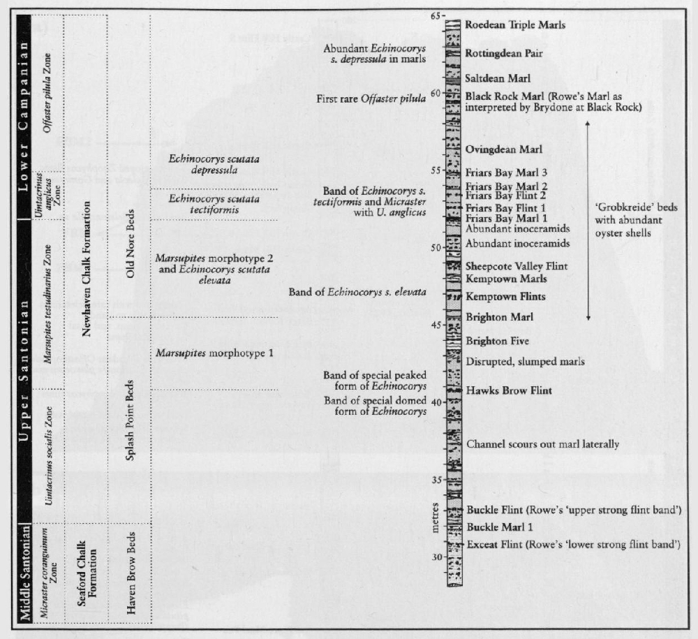
The Upper Santonian Uintacrinus socialis Zone (39 m) and Marsupites testudinarius Zone (27.5 m) are very well developed here, although their original recorded lower limits (Rowe, 1904) have been revised downwards (Whitham, 1993; Mitchell, 1994, 1995b) on the basis of bed-by-bed collecting, in the case of the Uintacrinus socialis Zone, by as much as 6 m. The thicknesses of the two zones are very much greater than in the Southern Province, where, at Seaford Head (Cuckmere to Seaford GCR site), they are 8 m and 10.6 m respectively (Mitchell, 1995b). They are also thicker here than in the correlative chalk facies standard section at Lägerdorf in northern Germany (Schonfeld and Schulz, 1996). This expansion of the Santonian, and also of the overlying Lower Campanian, successions compared with those in other areas is one of the most remarkable features of the higher part of the Chalk of the Northern Province.
There is a small overlap between the highest occurrences of Uintacrinus socialis and the lowest occurrences of Marsupites testudinarius. In the M. testudinarius Zone, Mitchell (1995b) recorded five discrete flood occurrences of the index crinoid
The beds between the upper limit of Marsupites and the top of the section by Sewerby Steps, including the famous Flamborough Sponge Beds, were assigned by Rowe (1904) to the local zone of Inoceramus (now Sphenoceramus) lingua, which replaced the lower part of the Zone of Actinocamax quadratus then applied in the south. Sphenoceramus lingua (as used in England and Germany) is an unfortunate choice as zonal index fossil: as shown by Seitz (1965), this species concept can strictly be applied only to the holotype, which is an incomplete specimen that does not preserve the adult ornament. The interval in question is characterized by S. patootensiformis (Seitz) and S. angustus (Beyenburg), and is commonly assigned to the S. patootensiformis inoceramid bivalve Zone (
The Flamborough Sponge Beds consist of just over 10 m of chalk, with the basal beds lying some 15.5 m above the base of the lingua Zone (Whitham, 1993). These beds contain a spectacular, abundant, mixed assemblage of three-dimensionally preserved lithistid and hexactinellid siliceous sponges, in which the lithistids predominate (Reid, 1968). It is one of the most important and most diverse Upper Cretaceous sponge assemblages in Britain, apart from that of the Chalk Rock.
Offaster pilula (Lamarck) is recorded from one bed in the succession above the Sponge Beds and is the only evidence for the O. pilula Zone in the Northern Province.
Whitham (1993) recorded the appearance, in the highest beds of Flamborough Chalk preserved at Sewerby Steps, of the heteromorph ammonite Discoscaphites (now Scaphites) binodosus (Roemer), which he took to mark the base of the Discoscaphites binodosus Subzone (Wright and Wright, 1942) of the Inoceramus (Sphenoceramus) lingua Zone. This ammonite, together with common Sphenoceramus spp., characterizes the fauna of the flintless chalk succession exposed in the quarries on top of the Wolds. Scaphites binodosus, which was originally described from Westphalia in Germany, is restricted there to the Lower Campanian lingua/quadrata Zone (Kennedy and Kaplan, 1995b), which equates approximately with the Echinocorys depressula Subzone of the Offaster pilula Zone of the Southern Province. On the basis of the ammonite and inoceramid bivalve faunas, there is no evidence that the currently exposed inland chalk in Yorkshire extends any higher than this. However, faunas recorded (Wright and Wright, 1942; Whitham, 1993) from now backfilled pits north of Bridlington, including the only known specimen from the Yorkshire Chalk of the belemnite Belemnitella from the White Hill Reservoir section, may indicate a higher horizon, but the occurrence of Scaphites binodosus still places these sections in the lower part of the pilula Zone.
Conclusions
The Flamborough Head site spans the entire Northern Province Upper Cretaceous succession and is therefore crucial to the interpretation of the successions in the adjacent North Sea Basin. The site is unique in its exposures of a very complete and expanded Lower–Upper Cretaceous boundary succession in red chalk facies at Speeton Cliff. The base of the Cenomanian Stage can be recognized on the basis of stable isotope stratigraphical correlation with the boundary stratotype section in southern France. The greatly expanded Cenomanian succession (compared with other Northern Province sections) has been investigated in respect of macrofossil and microfossil biostratigraphy, cyclostratigraphy and stable isotope stratigraphy and compared with the standard successions in the Southern Province, such as those found at the Southerham Grey Pit and Folkestone to Kingsdown GCR sites. The Santonian–Lower Campanian succession is more expanded here than anywhere else in the UK and provides a key reference section for the base of the Campanian Stage. Parts of the Dowsing Fault structure intersect the coast in the northern part of the site, illustrating the influence of such structures on the deformation of the Chalk.