Chapter 1 General introduction The Permo-Triassic world
Scope of the volume
The present volume describes sites selected for the Geological Conservation Review that exemplify the Permian and Triassic red-bed sediments of Britain. Although the main focus of the book is the Permian and Triassic continental sediments, 13 sites that represent the British marine
The Permo-Triassic world
The Permian and Triassic periods, ranging from about 291 to 199 million years (Ma) ago, were times of major change on the Earth. During this time, through plate tectonics, the continents moved together to form the supercontinent Pangaea ('all Earth'), a single landmass that extended virtually from pole to pole, and which allowed animals to migrate unimpeded from what is now 'Australia' to what is now 'Canada'
There were also immense changes in climates as well as in palaeogeography. The Permian Period began with a major glaciation in Gondwana (a southern hemisphere supercontinent that had fused with Laurasia to form Pangaea). The glaciation began in the Carboniferous Period and came to an end during the Early Permian Epoch. Elsewhere, climates throughout the Permian and Triassic periods were generally hot, and conditions commonly arid. Indeed, much of the classic Permo-Triassic succession in Great Britain, and elsewhere, consists of 'red beds', sediments laid down in generally hot conditions either in deserts or in rivers and lakes, their predominant red-iron coloration attesting to the highly oxidizing environments in which they accumulated.
Mass extinctions
There were vast planet-wide upheavals twice during this time interval, one at the end of the Permian Period, 251 Ma ago, and the other at the end of the Triassic Period, about 199 Ma ago. These were two of the 'big five' mass extinctions when many diverse groups of plants, animals, and microbes suffered unusually high levels of extinction
The end-Permian mass extinction was by far the largest ever on Earth. Perhaps as many as 96% of all marine species became extinct, while on land more than three-quarters of all vertebrate families were lost; only 4% of known species survived through the event into the Triassic Period. This is the nearest that life on Earth has yet come to total annihilation.
Although there is little fossil material in the red beds at the Permian–Triassic boundary in Britain that exemplify the impact on the fauna and flora, comparisons of the fossil record from marine Permian rocks and marine Triassic rocks reveal the extent of faunal changes
Life had flourished essentially unchallenged during the Carboniferous and Permian periods: crinoids, corals, nautiloids, ammonoids and fishes diversified in the seas, and amphibians and mammal-like reptiles continued their invasion of the land. However, after more than 100 million years of relative stability, the end of the Permian Period was marked by huge changes to the life of the time; these were far more devastating than the much more famous end-Cretaceous mass extinction when the dinosaurs died out.
In the sea, reefs were destroyed, and with them disappeared the last of the rugose and tabulate corals, as well as major groups of bryozoans, echinoderms, foraminifera, ostracods, brachiopods, gastropods, bivalves, ammonoids, nautiloids, and fishes. This huge 'clear-out' of classic Palaeozoic animals opened the way for new groups of corals to arise later in the Triassic Period, and for previously minor groups of bryozoans, bivalves, echinoderms, and ammonoids to come to the fore.
On land too, the end-Permian mass extinction destroyed the complex ecosystems of amphibians and mammal-like reptiles, and left only remnants behind in the earliest Triassic times, from which arose the dinosaurs, pterosaurs, marine reptiles, and mammals. Some of these terrestrial forms appear sporadically in the fossil record, either as skeletal remains or as footprints in the British Permo-Triassic red beds, but the record is sparse.
The magnitude of the crisis is indicated by the recovery phase in the Triassic Period. Whole habitats had gone and took millions of years to return. For example, it took 20 million years before new kinds of reefs became re-established, being built, of course, by organisms different from those that built the Permian reefs. After the end-Permian event there is a famous 'coal gap', when no coal is found at all: the forests had been devastated, and burial of plant material in significant quantities came to a complete halt for 20 million years. The diverse and complex ecosystems of mammal-like reptiles, including massive, rhinoceros-sized plant-eaters, and sabre-toothed gorgonopsians that preyed on them, were gone, and only some small to medium-sized amphibians and reptiles inhabited the Early Triassic world. However, 30 Ma later, ecosystems had begun to diversify on land again, and this coincided with the radiation of the dinosaurs.
Many causes have been proposed for the end-Permian mass extinction, including changes in sea level or salinity. At one time, a key cause was thought to have been the coming together of the continents to form the supercontinent Pangaea
Further minor extinction events in the Triassic Period, at the end of the Olenekian Age, c. 245 Ma ago, and at the end of the Carnian Age, c. 220 Ma ago, were responsible for killing off some animal groups, but they did not affect all of life. The end-Carnian event in particular was associated with a major turnover of vertebrates on land: dominant herbivorous mammal-like reptiles disappeared, and the dinosaurs radiated explosively into the abandoned environmental niches. However, the end-Triassic event —another of the 'big five' mass extinctions — was smaller than the end-Permian event, witnessing the loss of perhaps 50% of species, particularly those in the sea. This was again perhaps associated with anoxia and major sea-level change (Hallam and Wignall, 1997). There is some slightly stronger evidence for asteroid impact at the Triassic–Jurassic boundary (there are indicators such as some weakly 'shocked' quartz, and some iridium — Hallam and Wignall, 1997), but that evidence is not wholly convincing.
Stratigraphy of the Permian and Triassic successions
The Permian: international standards
The Permian System was named and defined by Murchison (1841), and was based on the sequence of marine and continental rocks he had seen around the town of Perm, on the west side of the Ural Mountains, and in the mountains and plains to the west and south. It was clear, before he went to Russia in the company of E. de Verneuil and A. von Keyserling, that there was a distinct stratigraphical unit between the Carboniferous and the Triassic rocks of Germany and Great Britain, which was then called, rather inadequately, the 'early' or 'lower New Red Sandstone'. However, in western Europe, it had been hard to define where this unit began and ended. In Russia, Murchison found floras and distinctive faunas of invertebrates, fishes, and land tetrapods, which provided a basis for the separation and recognition of 'Permian' strata, which could then be recognized in western Europe by comparison of faunas.
Murchison's 'Permian System' comprised rocks later assigned to the Kungurian, Kazanian, and Tatarian stages, essentially the Middle and Upper Permian
The Russian sections are not entirely satisfactory as a global standard succession, since parts of the sequence are missing, and the upper parts are continental. Although fossils are present in these upper units in the Ural Mountains, they are mainly plants and continental invertebrates and vertebrates, including amphibians andreptiles, and are of limited use in global correlation because of their comparative rarity. Debate has continued since the 1970s about the relative merits of more complete and fully marine sections in China and North America in particular, and a new stage nomenclature
The British Permian succession
Permian rocks occur widely in the British Isles, in a number of separate ancient depositional basins, from the Hebrides and west of Scotland, through the English Midlands, to Devon. In places, the successions are entirely continental, but in others there is a change from earlier, broadly continental, sedimentation, to later, broadly marine, deposition. There are also volcanic rocks of Permian age at some localities.
The stratigraphy of the British Permian red beds has long been problematic. At first, in the early 19th century, all red beds between the readily identifiable marine and coal-bearing Carboniferous and the marine Lower Jurassic strata were termed collectively the 'New Red Sandstone'. After the introduction of the term 'Triassic' in Germany in 1834, the lower 'New Red Sandstone' had a variable definition, equating with what in Germany were termed the 'Rotliegendes' (red beds) and the 'Zechstein' (marine limestones and evaporites), and often also the overlying 'Unter Buntsandstein'.
The earlier Permian succession in Great Britain, dominated by continental deposits, is particularly hard to subdivide and correlate, since the styles of sedimentation are almost certainly specific to each basin. However, Smith et al. (1974, pp. 6–7) argued that there were some broader-scale changes in climate and landscape through the Early and early-Mid Permian times that would probably be reflected in the sediment types, and which might provide a rough guide to correlation. Hence, they noted that, in each basin, there is a general tendency for water-laid sands and breccias to be succeeded by aeolian sands, reflecting a decrease in rainfall and relief through time. These are followed by water-laid sediments deposited following an increase in rainfall, perhaps associated with the Zechstein transgressions. These broad changes in the physical environment have been used to provide very rough correlations when other evidence is lacking.
Dating of the Permian red beds is difficult. Plant fossils and reptile bones and footprints have been reported from a few scattered localities, and these provide very rough indications of age, but at best only to stage level, by comparison between basins in the British Isles, and by comparison with Permian red bed successions in France, the Netherlands, Germany, Poland, and Russia. Interbedded volcanic rocks in some of the British Permian red-bed sequences have provided radiometric dates that are invaluable in providing evidence of age in palaeontologically barren successions.
The Zechstein transgression provides an important time datum, if the assumptions about that transgression (see below) are correct. Dating within the marine Zechstein facies is relatively straightforward, based on the range of marine fossils, even though the eastern (Zechstein) and western (Bakevellia) basins in the north of England were separated by the Pennine Ridge. These marine units have been described in a separate Geological Conservation Review (GCR) volume, Marine Permian of England (Smith, 1995).
The base and top of the Permian System in Great Britain are hard to define (Smith et al., 1974, pp. 8–10). It is believed that, in most basins, there was a hiatus in sediment deposition around the end of the Carboniferous and the beginning of the Permian periods, but the duration of the gap is hard to define because of the general absence of fossils. So, in some basins, the lowest continental red beds may be Stephanian (latest Carboniferous) in age. In the Mauchline Basin in south-west Scotland, plant fossils suggest that the lowest red beds are probably of earliest Permian age, and this is accepted broadly for other basins that contain similar red beds.
In the English Midlands, red-bed sedimentation began in the Late Carboniferous Epoch, and the onset of such continental conditions is dated as Westphalian D. In particular, the Keele Beds and the Enville Beds have shuttled between the Carboniferous and the Permian. The current view (Smith et al., 1974; Glover and Powell, 1996; Bridge et al., 1998; Powell et al., 2000) is that the Keele Beds are Stephanian in age, and the Enville Beds are also latest Carboniferous, even though definitive fossil evidence is lacking. The base of the Permian succession in the Midlands is tentatively placed at the base of the
The definition of the top of the British Permian succession is highly subjective since there is no fossil or radiometric age evidence to constrain closely the Permo-Triassic boundary anywhere in the British Isles (Pattison et al., 1973; Smith et al., 1974, pp. 7–8; Warrington et al., 1980, pp. 9–10). The only hint of dating evidence comes from palynomorphs in the isolated Kingscourt Outlier in Ireland (Gardiner and Visscher, 1971; Visscher, 1971), which constrain the boundary within a 30–60 m section. This is discussed further below (in the section entitled 'The revised scheme for the British Triassic succession') and in the introduction to Chapter 3 of the present volume.
The classic Germanic divisions of the Triassic succession
The Triassic succession of Great Britain is divided into a number of stratigraphical units that are generally hard to assign confidently to the Lower, Middle, and Upper Triassic divisions. For this reason, the Triassic red-bed units throughout the country are all treated together in Chapter 3. The uppermost Triassic sites that include the marine-influenced
In Europe, the Triassic System is represented in the north by the 'Germanic' sequence, which is largely continental in origin, and in the south by the essentially marine Tethyan sequence. The standard global stratigraphical schemes for the Triassic strata were based first on the Alpine successions that contain ammonoids and other biostratigraphically useful fossils. More recently, attention has switched to marine successions in North America (Tozer, 1967, 1979, 1984; Silberling and Tozer, 1968). Macrofossils are rare, or absent, in many units of the Germanic Triassic succession, and correlation of that largely red-bed continental succession with the marine successions was difficult, prior to the development of palynological studies since 1960.
The name 'Trias' was proposed by Alberti (1834) to unite the then three divisions, 'Bunter', 'Muschelkalk', and 'Keuper', of the succession in Germany. These lithostratigraphical divisions have often been equated loosely with the Lower, Middle, and Upper Triassic series. However, the Bunter and Keuper are partly of Mid Triassic age, and the Muschelkalk represents only part of Mid Triassic time. The Bunter–Muschelkalk and Muschelkalk–Keuper boundaries are apparently diachronous across the Germanic basin. Classically, the British Triassic red beds were equated, as far as possible, with the Germanic Triassic strata. However, there have always been problems in using this scheme, not least because the marine Muschelkalk is not developed in Great Britain. Hence, an independent stratigraphical system was proposed by Warrington et al. (1980). The development of Triassic stratigraphy in Britain is summarized below
From the beginning of the 19th century British geologists recognized a unit of generally red sandstones and mudstones lying between the Carboniferous and Jurassic strata. This evidently continental intercalation between two clearly marine systems was called the 'New Red Sandstone', to distinguish it from the other thick unit of red sandstones that lay below the Carboniferous rocks, the 'Old Red Sandstone'. It proved hard to subdivide the New Red Sandstone, largely because fossils were rare or absent. For example, Sedgwick and Murchison (1829a), in describing the New Red Sandstone of northern England, identified seven lithological divisions, the upper two of which, the 'Upper red sandstone' and 'Upper red marl and gypsum' were equated with the German Bunter and Keuper respectively. Geologists continued to use the term 'New Red Sandstone' well into the middle of the 19th century, especially for the red and yellow sandstones that might have been either Permian or Triassic in age, but Alberti's term 'Trias' was introduced to England through the 1830s and 1840s.
This rather unsatisfactory situation continued until the results of the British Geological Survey's remapping of the English Midlands were published by Hull (1869). He divided the Midlands Triassic succession into units that he equated with the German sequence
Problems with the Germanic scheme in Great Britain
Lithostratigraphical and biostratigraphical work in the 1960s and 1970s led to some revisions, and eventually to the abandonment of Hull's (1869) scheme. Pugh (1960) recognized two halite-bearing formations in the Keuper Marl of Cheshire, and these provided the basis for subdivision. In Nottinghamshire, Elliott (1961) defined a succession of eight formations, six of which were divisions of the Keuper Marl. However, both of these schemes were purely lithostratigraphical, and had only local application. Resolution came with the beginning of palynological work on borehole data from the Southern North Sea Basin and central and eastern England (Warrington, 1967, 1970a,b; Geiger and Hopping, 1968; Smith and Warrington,1971). This enabled correlation between the British and German successions, and resolved a number of outstanding stratigraphical problems. Warrington et al. (1980) summarized the three key findings that came from the palynological studies.
- There are sedimentary successions of Mid Triassic age in Great Britain. The Muschelkalk facies itself may not be developed in the British Isles, but deposits of the same age occur in red-bed sequences. The 'Lower Keuper Sandstone' of Hull (1869) comprises rocks equivalent in age to part of the German Upper Bunter and Muschelkalk; thus, his use of the terms 'Bunter' and 'Keuper' is not meaningful, and they are best abandoned when referring to the British Triassic succession.
- Many of the Triassic facies in Great Britain are diachronous. For example, the base of the Keuper Marl is older in west Lancashire than in the Midlands.
- Hull's (1869) stratigraphical scheme for the Triassic red beds of the Midlands cannot be applied readily in all other areas. It had been assumed that the particular sandstone and mudstone units that he recognized had a wide geographical distribution. This is not necessarily the case. Most of the units that he identified in the Midlands are of local extent only, and the Triassic succession in other basins is often quite different.
The revised scheme for the British Triassic succession
In making their radical proposals for a major overhaul of the British Triassic stratigraphical scheme, Warrington et al. (1980, pp. 9–11) noted the difficulties in establishing objective chronostratigraphical correlations. The base of the Triassic System cannot be identified with confidence anywhere in the British Isles, despite the fact that many successions apparently span the Permo-Triassic boundary (Pattison et al., 1973). These boundary sequences are virtually all unfossiliferous, and the only hint of dating evidence comes from palynomorphs in the isolated Kingscourt Outlier in County Cavan, Ireland (Gardiner and Visscher, 1971; Visscher, 1971; see
The upper boundary of the Triassic System is defined by the base of the Jurassic System, which is internationally recognized as being at the base of the planorbis subzone of the planorbis Ammonite Zone of the Hettangian Stage (George et al., 1969; Cope et al., 1980; Warrington et al., 1980). The lowest few metres of the Lias, the 'Pre-planorbis Beds', are regarded as Triassic in age; this is discussed in more detail in Chapter 4.
It has not been possible to place international chronostratigraphical stage boundaries within British Triassic successions with any confidence (Warrington et al., 1980, pp. 10–11), but it seems probable that all stages, the Induan, Olenekian, Anisian, Ladinian, Carnian, Norian, and Rhaetian, are present; locally palynology and magnetostratigraphy have provided more precise correlations with the marine standard. In other cases, fossil macroplant remains, fishes, and even tetrapods have been used to establish general ages, usually no more precisely than to stage level. However, in some British Triassic sedimentary basins, there are no fossils of any kind, and in the absence of radiometric dates or magnetostratigraphical evidence, there is virtually no constraint on age.
Warrington et al. (1980) proposed a lithostratigraphical scheme for the British Triassic succession. The classic terms 'Bunter' and 'Keuper' were abandoned, as were a number of other poorly defined terms (e.g. Waterstones'). Formations recognized in Triassic sequences in Britain constituted three major lithostratigraphical units, the
The
The
The Penarth Group
This volume includes coverage of the
The
Structural setting
Introduction
The Permo-Triassic basins of the western UK follow a roughly north-south linear rift system, the Clyde Belt (McLean, 1978; Coward, 1995), which was strongly influenced by the underlying structural grain. A number of different rift systems can be identified (Ziegler, 1990) that contain a large number of individual basins, typically with a basin fill of 1–4 km of mostly continental red beds and evaporites. Isopach maps constructed for the Triassic strata of northwestern Europe (Ziegler, 1990) suggest that the line of maximum Triassic subsidence located along the axis of the Clyde Belt (McLean, 1978; Coward, 1995) can be connected southwards through the Stafford Basin and the Worcester Graben to depocentres associated with the Pays de Bray fault and the Paris Basin. While the basins of the Clyde Belt constitute half-grabens, they display a pronounced degree of internal complexity, allowing a number of discrete structural styles to be identified (Jackson and Mulholland, 1993).
Major earth movements continued from Late Carboniferous into Early Permian times, particularly in the south of England. These earth movements, part of the Variscan or Hercynian phase of mountain building, resulted from Gondwana moving northwards against Laurasia. Suturing took place along a line within the current Mediterranean Sea, but the resultant north–south compression propagated northwards into southern England, Wales, and Ireland.
The onshore outcrop of Permo-Triassic red beds represents the surface expression of much more extensive and thicker successions that are present at depth on the UK Continental Shelf (UKCS) area. The correlation between surface and subsurface sections is relatively well known as a result of seismic reflection surveys (e.g. Chadwick and Evans, 1995) and correlation with deep onshore boreholes (Whittaker et al., 1985).
Three main structural trends are recognizable from a map of the main Permo-Triassic basins in the UK
1. Wessex and English Channel Basin System
The Wessex-Channel Basin System comprises a number of sub-basins: from south to north the Lyme Bay, Dorset, Wardour, and Pewsey basins, all with an overall east-west trend reflecting formation by extensional re-activation of Variscan compressional structures (Chadwick, 1986). The thickness of concealed Permo-Triassic rocks in the Wessex Basin locally exceeds 1500 m but decreases rapidly to the north (Whittaker, 1985; Hamblin et al., 1992, fig. 19). Sediment distribution in these basins was controlled by predominantly east-west syndepositional faults, with alluvial fan and braidplain sandstones proximal to the faults and medial–distal braidplain sandstones farther away. West of the River Exe, Permian continental sediments sit unconformably on older Palaeozoic strata. Here fluvial transport was from the west into a series of palaeovalleys or cuvettes, and aeolian sands migrated westwards into the valleys. The Triassic regional sediment transport was to the north or NNW, with the east-west structural grain exercising local controls
2. Worcester Basin and Severn-Bristol Channel Basin
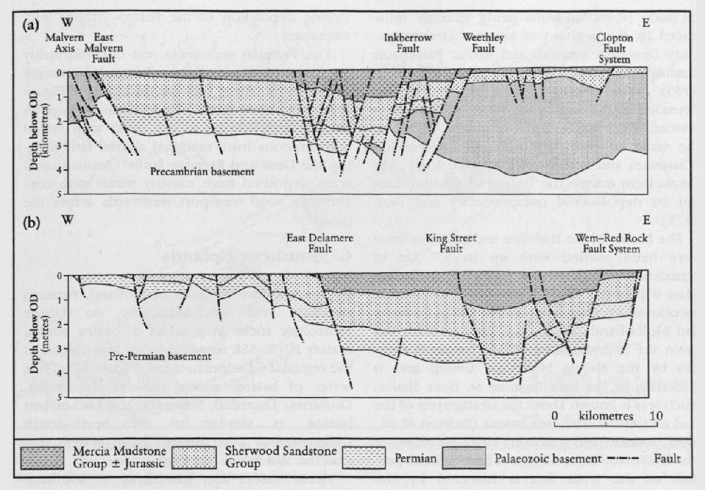
The Worcester Basin is a north-south graben system bounded to the west by the East Malvern Fault, a major normal fault with a downthrow of over 2500 m in places (Chadwick and Evans, 1995). To the west the basin is flanked by Precambrian and Lower Palaeozoic rocks and to the east by concealed Palaeozoic rocks of the London platform. The present-day configuration of the basin is more or less symmetrical with the eastern margin formed by the Clopton fault system, but in Triassic times the basin may have been asymmetrical, with the depocentre close to the east Malvern fault
Only youngest Triassic rocks are seen on the west Somerset and South Wales coastlines, bordering the Severn-Bristol Channel Basin, and in the Mendip Hills where some deposits are confined to fissures in the Carboniferous Limestones. In Glamorgan, marginal alluvial fans were sourced from ridges of Carboniferous Limestone and prograded southwards towards the Bristol Channel.
The infill of the Worcester Basin includes both Permian and Triassic red beds with a maximum thickness of just over 3 km. The Permian succession comprises the Haffield Breccia and the
3. East Midlands-Southern North Sea (SNS) Basin
The East Midlands shows little structure compared with the more westerly basins and the only syndepositional faults lie offshore (e.g. Dowsing Fault Zone in the SNS Basin). The Permo-Triassic dips gently into the SNS Basin, and extends northwards into the main Central Graben and Viking Graben, which reflect the east-west palaeostress pattern initiated later in the opening of the North Atlantic. Palaeocurrents in the
4. Cheshire Basin–East Irish Sea Basin
The Cheshire and East Irish Sea basins constitute part of the Clyde Belt (McLean, 1978), a NW–SE-trending chain of deep Triassic troughs stretching from the Highland Boundary Fault to the Cheshire Basin. The formation of these basins has been linked with an episode of extension associated with an early phase of Atlantic opening (Ziegler, 1982, 1990). Structural styles in this area are extremely diverse, with the locationof basin bounding-faults being strongly influenced by the position of buoyant Ordovician–early Devonian granites and earlier Palaeozoic basement structures (Jackson and Mulholland 1993). The Cheshire Basin is a half-graben bounded on the east by the Wem–Red Rock fault system, which has a throw of about 3500 m at the base of the Permo-Triassic succession (Chadwick and Evans, 1995)
The basins of the Irish Sea and adjacent areas have been infilled with up to 5.7 km of Permian-Lower Jurassic sediments including what is probably the thickest (4375 m) Triassic succession encountered on the UKCS (Jackson and Mulholland, 1993). In the East Irish Sea Basin the
5. Vale of Eden Basin
The Vale of Eden is a north–south-trending fault-bounded basin flanked to the east by Carboniferous and Lower Palaeozoic rocks of the Askrigg and Alston blocks. As in a number of the other basins, the structural trend reflects the structural grain of the basement. However, the history of the Dent–Pennine Fault System that forms the eastern boundary of the basin is complex. The faults were initiated as an extensional system in Dinantian times and then re-activated during oblique strike-slip compression in the late Carboniferous Variscan orogeny (Underhill et al., 1988). Subsequent extension occurred during deposition of the Permo-Triassic infill sequence.
The Permian sediments rest unconformably on Carboniferous rocks on the western margin of the basin, where they are thickest (see
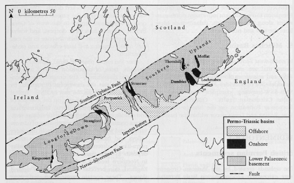
6. Southern Uplands
In the Southern Uplands of Scotland, Permian deposits rest unconformably on Lower Palaeozoic rocks in a series of basins with a mainly NNW–SSE trend, more or less normal to the regional Caledonian trend
These basins are, like those in southern Britain, controlled by the structural grain of the basement rocks. Their present geometries result from dissection by later faulting. They are fault-bounded on their eastern margins and associated with normal faults that downthrow to the west. The faulting is associated with counterclockwise rotation of up to 40° of the basement rocks and overlying Permian sediments. This rotation, associated with ENE–WSW extension, was generated at the time of formation of the basins (Anderson et al., 1995).
7. Moray Firth
The Moray Firth Basin is a NE–SW-trending basin strongly controlled by the underlying Caledonian structural grain. There is a large array of faults that were re-activated during Mesozoic extension and that controlled the deposition
The Permian and Triassic rocks crop out on the southern margin of the basin and rest unconformably on Devonian and older rocks.
Palaeocurrents from the
8. Minches Basin
In north-west Scotland are a number of Triassic basins that are mainly known from offshore wells and seismic exploration. These form the Hebrides–Sea of Hebrides–North Minch Basin, a NNE–SSW-trending complex controlled by major Caledonian faults. Outcrops of the
Sedimentology
British Permian sediments
The uplands created by the Variscan Orogeny were extensively eroded during Early Permian times, levelling the rugged scenery to a rolling peneplain, and generating thick accumulations of alluvial red-bed sediments. These sediments were deposited unconformably on top of eroded marine Carboniferous sediments in most parts of the country, except in parts of the Warwickshire coalfield, where sedimentation may have been continuous from Carboniferous into Permian time, and in Devon, where continental red bed deposition may have started in the Late Carboniferous Epoch (see above). In places, weathered profiles occur in the rocks immediately underlying the red beds.
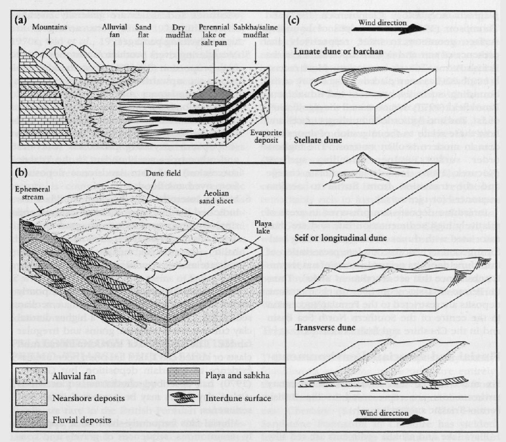
The Permian red beds accumulated as alluvial fans around the mountainous areas, and filled subsiding basins between the mountains
After the initial phase of rapid erosion of the uplands, rates of deposition slowed and the grain size diminished. The dominant sedimentary process was the movement of material by prevailing winds from the east or ENE. Typical sediments include screes around the margins of the basins, overlapping alluvial fanglomerates and sandstones interdigitating with similar sediments coming from the opposite sides of narrow valleys, and with aeolian sandstones in the wider valleys and basins. The largest basins show playa-like mudstones in the centres, with halite deposits in some parts of the North Sea Basin. In Northern Ireland and northern and central England, thin breccias accumulated on upland slopes. These contain exotic clasts, indicating long-distance transport, but their origin is unclear.
The Early and early Mid Permian sediments are largely red and buff in colour, indicating arid climatic conditions. Fossils are rare, but the landscape was clearly not devoid of life: fossil plants have been found in association with volcanic rocks in the Mauchline Basin of south-west Scotland (Wagner, 1983) and in the Ashow Group of the English Midlands. Sporadic vertebrate footprints in early Mid Permian strata also give a hint of the life of the time.
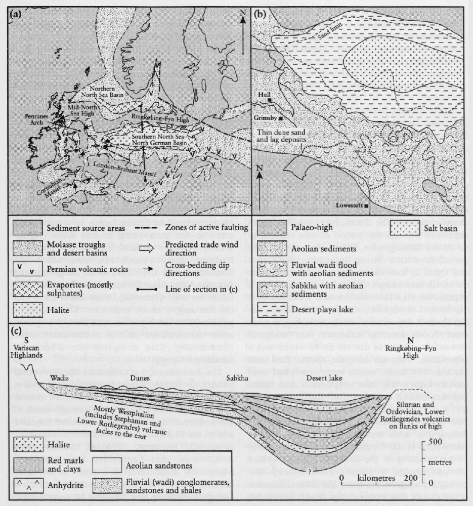
Studies in the North Sea Basin (Glennie, 1972; Rhys, 1974; Marie, 1975; Smith and Taylor, 1992; George and Berry, 1993) have helped to elucidate the palaeogeography and climatic conditions of Early and early Mid Permian times. These authors have recognized fluvial, aeolian, lake-sabkha, and desert-lake environments in what was a low-lying continental area extending from northern England across the North Sea and the Netherlands into Germany, termed the 'Rotliegendes Basin', which includes the Southern North Sea Basin
- In the southern part of the basin, abutting against the London–Brabant Massif
(Figure 1.9) a,b, is an assemblage of sandstones with some conglomerates and breccias, sourced mainly from the neighbouring upland area. The conglomerates contain clasts of Westphalian coal measures and were deposited on alluvial fans and in river channels during flash floods. Some sands are well sorted and were probably reworked by subsequent aeolian processes. Finer-grained sediments contain mudcracks. This facies is seen also onshore in Arran and in south Devon. - The second major facies association, in the northern and central parts of the 'Rotliegendes Basin'
(Figure 1.9) a,b, consists of siltstones and claystones with evaporites. The monotonous red mudstones with occasional evaporites probably represent deposition in and around a sabkha lake. The absence of marine fossils suggests that this was a continental sabkha. These beds grade into halite-rich deposits that may indicate the former presence of a major desert lake in the middle of the basin(Figure 1.9) b,c.
This work has provided unique evidence for the desert lake, now seen only in offshore bore-holes, and helps to clarify the conditions of deposition seen onshore.
George and Berry (1993) recognized up to five major drying-out cycles in the Rotliegendes of the southern North Sea and argued that these have stratigraphical potential for basin-wide correlation, as they represent major long-term climatic cycles. The Southern North Sea Basin expanded through the period of time represented by the Rotliegendes, from being confined to the offshore area during deposition of Cycle 1 and Cycle 2, then extending progressively over the north-east margin of Norfolk during Cycle 3 deposition, then Lincolnshire and Yorkshire during Cycle 4 deposition, and finally Durham during Cycle 5 deposition. Each cycle began with sheet floods feeding sediment into marginal areas of the basin, at the centre of which was a desert lake. Through the cycle, alluvial fans built out into the basin, sands were reworked into aeolian dunes, the lake evaporated and halite deposits formed at the centre. Anderton et al., (1979, p. 184) visualized the end of Rotliegendes time in Great Britain as 'a shimmering desert' comparable with modern land-locked desert basins such as the Caspian Basin of Central Asia.
The incoming of the Zechstein facies marks a dramatic change to marine environments following a transgression from the Boreal regions in the north; this entered the North Sea Basin and extended over eastern England, and also formed the Bakevellia Sea in the Irish Sea Basin and areas on the north-west side of the British Isles. This transgression is thought to have spread rapidly across much of Europe (Smith et al., 1974, p. 5) because the first Permian marine faunas in Great Britain and central Europe (Germany, Poland, western Russia) are very similar, plant remains in the lowest deposits of the Zechstein and Bakevellia seas are similar, and because it has been linked to the final melting of the Gondwana ice sheet, implying a rapid and synchronous effect.
The Zechstein and Bakevellia sea sediments contrast with the earlier Permian red beds and consist largely of bedded dolomitic limestones, anhydrites, calcareous shales, and bedded halites, with unequivocal marine fossils. Here and there they are interbedded with minor land-derived clastic deposits. Everywhere, the marine sediments pass upwards into continental red beds.
British Triassic sediments
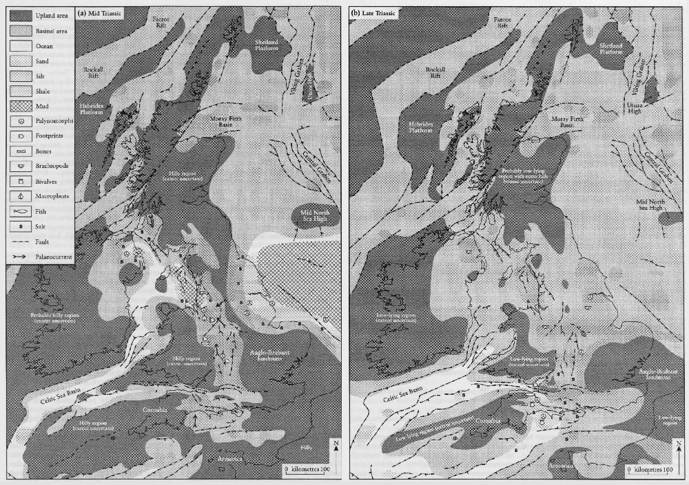
The hot and arid climates of the Permian Period continued into the Triassic. In the Early and Mid Triassic epochs, much of the British area was low-lying. Older mountain chains, in Scotland, Wales, parts of Ireland, Armorica (the ancient landmass over north-western France), and the Massif Central in France began to supply sediment to the intervening basinal areas
The formations that constitute the
Most of the coarse-grained facies of the
The conglomerate facies generally grade upwards into red sandstones and siltstones. These siltstones are mostly structureless, but ripple marks and desiccation cracks occur. Bands of nodular carbonate are common and show features characteristic of calcrete horizons or palaeosols (Steel, 1974b). Red siltstones occur throughout these facies. In some places, the silts are associated with evaporites or with evidence of former evaporitic minerals, such as gypsum and anhydrite. The silt sediments probably accumulated as overbank deposits of established fluvial systems or in playa lakes (Steel, 1974a). The calcareous palaeosols and evaporites indicate arid conditions.
The
In some areas of England, the lower part of the
The bulk of the
The scarcity of fossils and apparent rarity of sedimentary structures has made it hard to interpret these
- The sediments represent subaqueous deposition in an inland hypersaline lake or inland sea, or in bodies of water of marine origin.
- The sediments were deposited in giant playas or desert plains.
The first suggestion seems to represent the best explanation for the bulk of the succession (Warrington, 1974d, Arthurton, 1980; Ruffell, 1991). In some places, for example in the Worcester Graben and Cheshire Basin, thick accumulations of evaporitic halite with associated sulphate salts, were precipitated from waters of marine origin (the sediments contain acritarchs, microfossils found only in the sea). A commonly-suggested modern analogue is the Ranns of Kutch, India, an evaporitic coastal plain that is periodically flooded by both the Indus River and by monsoon-driven marine waters from the Indian Ocean.
The second suggestion is true only for the upper part of the sequence seen, for example, in southern Wales (Tucker, 1977, 1978). Tucker (1978) described 'fossil shorelines' around the margins of the South Wales Basin, where
Red beds of the British Permo-Triassic succession
Introduction
British Permian and Triassic red beds comprise a wide variety of deposits of continental environments ranging from alluvial fans, river channels and floodplains to aeolian dune fields, desert lakes, and coastal mud flats
Studies of the British Permo-Triassic red beds have been central to the development of ideas of continental drift and palaeomagnetism. This is largely because they have relatively strong and stable Natural Remanent Magnetization (NRM) carried by haematite. Runcorn (1965) produced polar-wander paths for Europe and North America and compared palaeomagnetic results from the Triassic strata of the Colorado Plateau and Europe that clearly indicated the opening of the North Atlantic Ocean.
The British Permo-Triassic red beds display a range of facies indicative of both aeolian and fluvial depositional environments.
Aeolian environments
- aeolian dunes and draa characterized by texturally mature sandstones with large-scale cross stratification with sweeping, asymptotic foresets. Maximum foreset inclinations are often up to 30° (approaching the maximum angle of repose of dry sand in air of 34°). Individual sets are separated by sharp, generally planar, bounding surfaces.
- Aeolian sandsheets that typically comprise bi-modally laminated sandstones on a millimetre-scale with well-rounded coarser laminations. Scours, granule lags, and thin cross-laminated units may be present.
- Damp interdune deposits comprising variably silty sandstones with irregular wavy or lenticular lamination and soft-sediment contortions. The dominant structures are adhesion ripples formed by the sticking of windblown sand to damp surfaces.
Glennie (1970) and other authors have attributed the high angle of dune foresets to compactional effects during burial, but removal by erosion of dune crests could also be a significant factor. A key element in identifying aeolian dunes is the recognition of grainflow and grainfall laminations (Hunter, 1977). In addition, horizontal or sub-horizontal aeolianites, particularly translatent strata and wind-ripple lamination, are important.
Early work by Shotton (1956) on the Permian Bridgnorth Sandstone demonstrated the link between the geometry of cross strata and dune planform morphology. Clemmensen (1987) and Thompson (1969) used analysis of bounding surface geometry to infer, respectively, the presence of star and dome-shaped dunes in the British Permo-Triassic succession. More recently emphasis has been placed on the nature of the bounding surfaces between individual sets. Brookfield (1977) demonstrated the significance of 1st, 2nd and 3rd order bounding surfaces and how these relate to the migration of dunes and draa in modern aeolian systems. The highest-order surfaces, super bounding surfaces (Kocurek, 1988), record major climate change and the transition from fluvial to aeolian sequences (or vice versa).
Interdune deposits are preserved in areas of relatively high sedimentation rate and are thus associated with dunes showing a climbing bed-form geometry. More complete preservation of interdune deposits occurs in areas of net tectonic subsidence that act as sediment 'sinks'. Thus, in Permo-Triassic sequences thick interdune deposits are restricted to the Permian succession in the centre of the Southern North Sea Basin and in the Cheshire and Irish Sea basins.
Fluvial and associated environments
Six major fluvial and associated sedimentary environments are represented in the British Permo-Triassic succession.
- Playa lake and sabkha sediments are red silty mudstones and claystones with thin sandstones. Sedimentary structures include ripple marks, desiccation cracks and footprint trails, with associated nodular anhydrites and algal laminites.
- Alluvial fanglomerates are poorly sorted gravels. Those deposited from ephemeral sheet floods show poorly stratified or imbricate gravels with upwards-fining profiles. Debris flows are matrix supported and show little or no internal organization.
- Coarse-grained braided rivers are indicated by texturally mature gravels with variable internal organization. Crude stratification, large-scale foresets, and interbedded cross-stratified sandstones are characteristic.
- Sandy braided rivers are represented by sandstones with upper-phase plane beds, planar-tabular and trough cross-stratification and subordinate siltstones. Planar-tabular sets may show re-activation surfaces. Interbedded siltstones and shales are generally laterally discontinuous. Units are arranged in upwards-fining packages.
- Meandering rivers produce sandstones with a high proportion (30–60%) of interbedded siltstones in upwards-fining sequences. The channel sandstones may show lateral accretion (epsilon) cross-stratification and a variety of smaller scale cross-stratified, rippled and plane bedded sandstones. The siltstones (floodplain) may have palaeosols (calcretes and other types are abundant in the Triassic succession) and thin sandstones deposited from overbank floods.
- Marine intertidal and brackish mudflats are indicated by thin heterolithic sandstones and rippled siltstones, often with mud drapes, desiccation cracks and pseudomorphs after halite. Trace fossils, including Lingulichnus, indicate marine conditions.
In general, fluvial sediments are more poorly sorted and less texturally mature than aeolian sediments. This is reflected by a higher detrital clay content, more angular grains and irregular fabrics. The presence of intraformational mud clasts or curled clay flakes has often been used as evidence of waterlain deposition, but Glennie (1970) has described conditions under which curled clay flakes may be preserved in aeolian sediments.
Alluvial fans frequently show thick, apparently monotonous, sequences of gravels and conglomerates with variable degrees of organization. Excellent examples occur in south Devon (Laming, 1966). Comparison with modern fans (Blair and McPherson, 1994) shows that both sheetflood- and debris-flow-dominated fans developed in Permian times, with sheetflood deposits predominating.
Much of the emphasis in fluvial sedimentological research has been on the relationship between channel pattern and the resulting geometry of the deposits (Miall, 1996). In the simplest case, the distinction between braided and meandering systems is made on the basis of the relative proportions of channel and floodplain deposits, and the vertical sedimentary profile. Meandering river deposits show upwards-fining profiles and, ideally, the preservation of lateral accretion (point-bar) cross-stratification and a relatively high proportion of flood plain fines. These deposits are relatively scarce in the Triassic succession, except in the BromsgroveSandstone Formation and parts of the
Recent research indicates that fluvial architecture is complex and sensitive to tectonic events and climatic changes. Channel patterns are complex; anastomosed channels are abundant in some arid-climate regimes and vertical changes may be the result of tectonic or climatic influence rather than fluvial processes and hydraulics. Some units have remained enigmatic and require resolution in terms of facies interpretation. These include the Wildmoor Sandstone and parts of the Wilmslow Sandstone formations.
Palaeontology of the British Permo-Triassic succession
Permian palaeontology
Fossils are rare in the British Permian red beds, and entirely absent in some basins. The amphibian Dasyceps and the pelycosaur reptiles Sphenacodon and Haptodus are known from the Kenilworth area of Warwickshire (Paton, 1974, 1975), as is the conifer Lebachia (= Walchia). A limited flora from the Mauchline Basin in south-west Scotland indicates a Late Carboniferous to probably earliest Permian age (Wagner, 1983).
Footprints of amphibians and reptiles have long been known from the
The extensive red beds of Devon and neighbouring parts of Somerset and Dorset are almost devoid of fossils. Mid to Late Permian palynomorphs from the
The latest Permian Hopeman Sandstone is, compared to other British Permian red beds, remarkably rich in fossils, having yielded some twenty specimens of the dicynodonts Gordonia and Geikia and the pareiasaur Elginia, all of which can be compared with close relatives in Late Permian strata of Russia and South Africa. Footprints of these, and other, reptiles have also been found to be abundant in the coeval sandstones of the Morayshire coast (Benton and Walker, 1985).
Triassic palaeontology
The
Fossils are relatively abundant in the upper units of the
The
These plants, invertebrates, and vertebrates indicate only a generalized Mid Triassic age. Palynological assemblages, of miospores in particular, have been more helpful in correlation to the North Sea and German successions, and to the marine Alpine successions (Warrington et al., 1980). Such assemblages have been reported from Lancashire, Cheshire, Staffordshire, Nottinghamshire, Worcestershire, Warwickshire, and Oxfordshire, and have allowed the ages of individual horizons to be determined to the level of subdivisions of the standard stages in some cases.
Younger formations have produced some excellent macrofossils that give general evidence of age. Miospores are rare in the continental parts of the Upper Triassic succession, that is, below the marine
In England, the Upper Triassic portions of the
Other fossils in the
Similarly hard to date, but perhaps even more significant palaeontologically, are the famous fissure faunas from the Mendips, Gloucestershire, and South Wales (Robinson, 1957; Fraser, 1994; Benton and Spencer, 1995). Infilled caverns and solution features, formed on uplifted Carboniferous Limestone in these areas, occasionally contain rich assemblages of reptile and mammal bones and teeth. During the Late Triassic Epoch, the tops of limestone islands around the Severn–Mendip area were eroded into a karst surface, and red-bed soils formed in places. The islands were evidently vegetated and supported rich faunas of sphenodontid lizards, dinosaurs, gliding reptiles, and mammals that occasionally fell, or were washed, into deep solution-cavities. Dating of the fissure fills is very difficult. Some contain palynomorphs indicating Rhaetian or Hettangian–Sinemurian ages, and these tend to contain different vertebrate faunas from those that lack palynomorphs. The latter are probably older and have vertebrate faunas that include reptiles, such as the crocodilomorph Terrestrisuchus and the pro-colophonid Leptopleuron, that are apparently identical with taxa from mid Norian strata of Germany and late Carnian deposits of Scotland respectively. Perhaps the fissures range in age from late Carnian to Sinemurian, spanning the Late Triassic and Early Jurassic epochs.
The
The palaeontology of the British
The Selection of Permian and Triassic red-bed and Penarth Group GCR sites
N.V. Ellis
This volume of the Geological Conservation Review (GCR) describes sites that were selected for the GCR because of their special significance in the study and understanding of British Permian and Triassic red-bed and
The general principles guiding GCR site selection are described in an introductory volume of the GCR (Ellis et al., 1996), but can be encapsulated in three broad components:
- International geological importance (e.g. stratigraphical 'type' sites and other sites that have achieved informal, but widely held, international recognition).
- Presence of 'classic' or exceptional features that are scientifically important (e.g. 'textbook' examples of particular sedimentologi-cal features or exceptionally rare occurrences).
- Presence of representative geological features (e.g. characteristic or typical features of British Permian and Triassic rocks) that are essential in comprehensively portraying the geological history of Britain.
However, in order to ensure true national importance in the selected representative sites, site selection was underpinned by the premise that the particular GCR Block should be represented by the minimum number of sites. Only those sites absolutely necessary to represent the most important aspects of Britain's stratigraphy were therefore selected. (Fwo GCR Blocks are relevant here — they were called 'Permian–Triassic Stratigraphy' and 'Rhaetian Stratigraphy' during the principal GCR site selection phase in the 1980s).
On an entirely practical level, all selected sites must be conservable, meaning in essence: (a) that development planning consents do not exist or else amendments can be negotiated; and (b) that sites are physically viable, for example, in terms of the long-term stability of exposures.
In order to compile the ultimate site list for the 'Permian–Triassic stratigraphy' and 'Rhaetian Stratigraphy' GCR Blocks, extensive consultations were carried out with appropriate geologists by the GCR Unit of the former Nature Conservancy Council in the 1980s, and a large number of sites were assessed before the final listing was produced. There are many problems inherent in producing a truly representative list of nationally important sites that merit conservation. In order to help provide a framework for selecting sites within a GCR Block, the concept of GCR Networks is applied.
GCR Networks
GCR Networks are the themes for site selection that link clusters of representative sites within a GCR Block, and these have influenced the structure of the present volume. Of course different themes could have been adopted here — types of sedimentary structures, sedimentological composition, diagenetical history, sequence of environmental change and so on — and these can be traced in the sites described in this book, but the principal theme for site selection and therefore the organization of the sites in this book is the representation of British depositional basins during Permian and Triassic times. Details of the geological scenarios that the networks represent can be found in the chapter introductions, but can be summarized as follows:
British Permian red-bed palaeogeographical, sedimentological and stratigraphical GCR networks (Chapter 2)
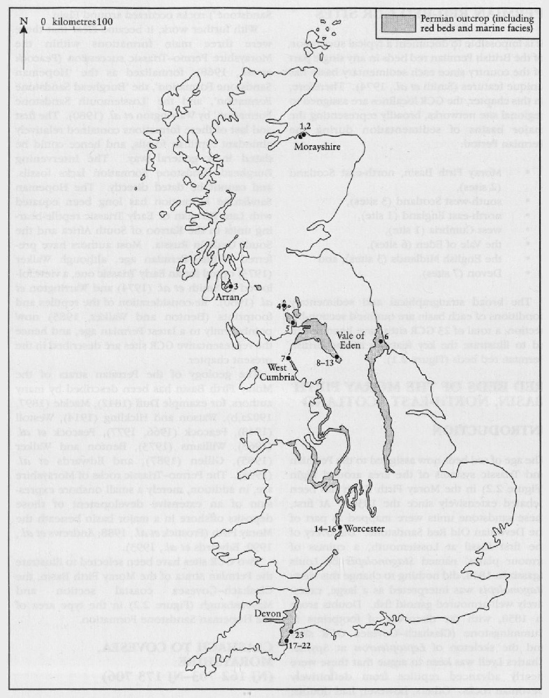
Because each sedimentary basin has distinct characteritsics, the GCR localities are assigned to regional site networks, representing broadly the major 'British' basins of sedimentation during the Permian Period. The broad stratigraphical and sedimentary conditions of each basin are outlined in Chapter 2. A total of 23 GCR sites have been selected to illustrate the key features of the British Permian red beds networks (see
- Moray Firth Basin
- south-west Scotland
- north-east England
- west Cumbria
- Vale of Eden
- English Midlands
- Devon
British Triassic red-bed palaeogeographical sedimentological and stratigraphical GCR networks (Chapter 3)
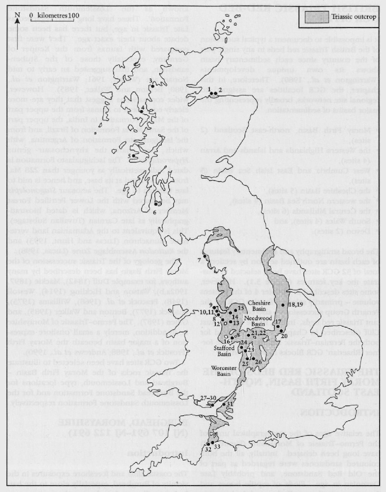
In the same way that the Permian red-bed GCR networks were devised, the GCR localities (32 in all) are assigned to regional site networks, listed below. The rationale for establishing such networks is to reflect the different characteristics of distinct sedimentary basins (see
- Moray Firth Basin
- Western Highlands and Islands and Arran
- west Cumbria and the East Irish Sea Basin
- Cheshire Basin
- western margin of the North Sea Basin
- Central Midlands
- South Wales
- Devon
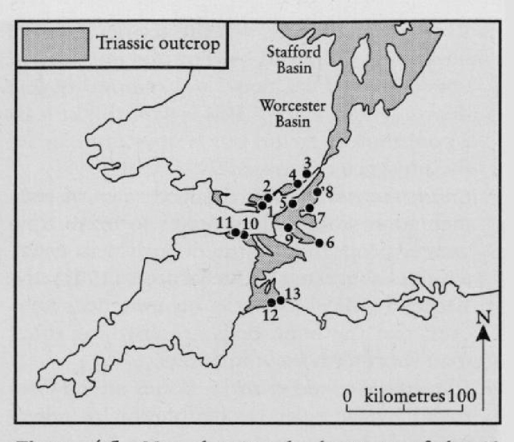
Penarth Group GCR networks (Chapter 4)
The
- South Wales
- Gloucestershire, Avon and north Somerset
- west Somerset
- Devon.