Chapter 3 The Middle Jurassic stratigraphy of the Cotswolds
M.G. Sumbler, B.M. Cox, R.J. Wyatt and K.N. Page
Introduction
B.M. Cox
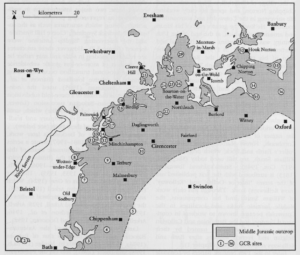
The Cotswold Hills, which extend for approximately 90 km from Bath in Somerset northwards to near Chipping Norton in Oxfordshire
The Middle Jurassic rocks of the Cotswold area have a long history of geological investigation, and feature prominently in the history of geology itself. William Smith (1769–1839), the so-called 'Father of English Geology', was born in the village of Churchill, c. 5 km south-west of Chipping Norton, and spent his early working life surveying in the Cotswolds and surrounding counties. He lived the greater part of his life in and around Bath, which, at the end of the 18th century, was an important centre of social and intellectual activities. In 1799, Smith, with the help of his two friends the Rev. Benjamin Richardson and the Rev. Joseph Townsend, both of whom were collectors of minerals and fossils, recorded the succession of rock units, together with their thicknesses and characteristic fossils, which he had established in and around the Cotswolds. Between then and 1816, following the publication of Smith's great geological map of England and Wales in 1815, this list of stratal names underwent several minor revisions, but the names of Middle Jurassic strata, such as Cornbrash, Forest Marble, Great Oolite and Fuller's Earth and Rock, which originated with William Smith, are still used today (Sheppard, 1917; Cox, 1948). Smith's friend Townsend (1813) is attributed with the first published use of the terms 'Inferior Oolite' and 'Kelloway' (now Kellaways) Rock. Through this early work of William Smith and his companions, the Middle Jurassic rocks and localities in the Cotswolds became known to workers in continental Europe, and the Bathonian and Callovian stages were subsequently named by their Belgian and French authors after Bath and Kellaways respectively (see Chapter 1).
Later in the 19th century, papers by Lonsdale (1832), Murchison (1834, 1845), J. Buckman (1842), Brodie (1851, 1853), Wright (1856, 1860), Witchell (1880, 1882a,b, 1886), Wethered (1891) and S.S. Buckman (1889a, 1890, 1892, 1893a, 1895, 1897, 1901, 1905), as well as [British] Geological Survey memoirs by Hull (1857) and Woodward (1894), provided further details of the local Middle Jurassic succession. The work of Sydney Savory Buckman (1860–1929) is of particular note for he recognized the two major non-sequences that interrupt the Aalenian–Bajocian succession. At these levels, the strata above the non-sequences overlap or overstep the older beds beneath. The episodes of erosion that caused these non-sequences were referred to by Buckman (1901) as the Aalenian and Bajocian denudations. They are marked by eroded, planed and bored, oyster-encrusted hardgrounds. Later, Arkell (1933) used the terms Bajocian and Vesulian transgressions for the renewed deposition that followed the denudations. Authors have generally perceived these two major interruptions in sedimentation as representing periods of tectonic activity during which structures such as the so-called 'Painswick Syncline', 'Cleeve Hill Syncline' and the intervening 'Birdlip Anticline' were formed
Around the time of Buckman's later work, Linsdall Richardson (1881–1967) wrote a series of papers on the Middle Jurassic strata of this area and two memoirs for the [British] Geological Survey (Richardson, 1904, 1906, 1907b, 1910, 1911a,b, 1929b, 1933, 1935). His later work coincided with that of Gray (1924), Welch (1927) and William Jocelyn Arkell (1904–1958), another major figure in stratigraphical studies of the Cotswolds (Douglas and Arkell, 1928; Arkell, 1931, 1933, 1934; Richardson et al., 1946; Arkell, 1951–1958; Arkell and Donovan, 1952).
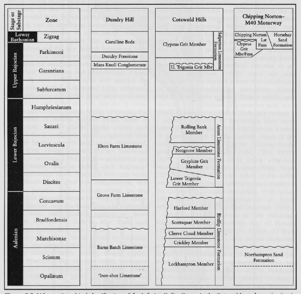
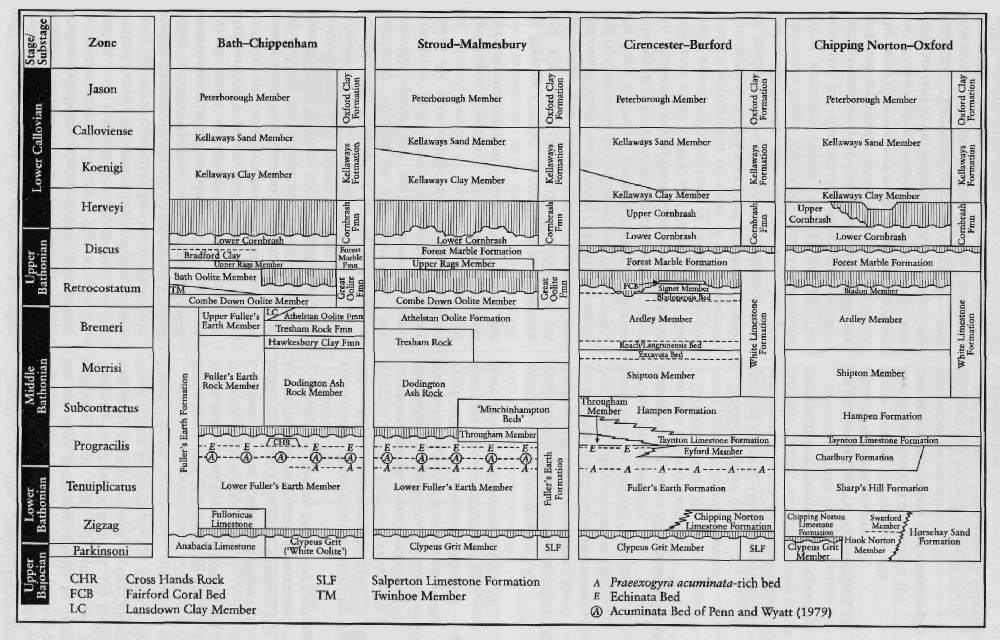
Later work on aspects of the Aalenian–Bajocian succession includes that of Parsons (1974a, 1976b, 1979, 1980a,b), Mudge (1978a,b, 1995) and Baker (1981), and on the Bathonian succession that of Green and Donovan (1969), Sellwood and McKerrow (1974), Palmer (1979), Penn and Wyatt (1979) and Sumbler (1984), and unpublished theses by Barker (1976), Bradshaw (1978) and Cripps (1986). [British] Geological Survey memoirs by Cave (1977) and Horton et al. (1987) include accounts of the Middle Jurassic successions in the Malmesbury and Chipping Norton districts respectively. More recent Survey work has led to a revised lithostratigraphy for the Aalenian–Bajocian succession (Barron et al., 1997), and revision of the Middle Jurassic strata of the Cirencester district (Sum-bler et al., 2000). In particular, these authors abandoned the use of the terms Lower, Middle and Upper Inferior Oolite in formal lithostratigraphy and replaced them with properly defined formations — Birdlip Limestone, Aston Limestone and Salperton Limestone, respectively. The correlation of the Bathonian succession of the Cotswold area, which displays rapid lateral and vertical lithological and faunal changes as a number of facies belts migrated basinwards with time, away from the London Landmass, is discussed by Wyatt (1996a) and Sumbler (1999).
The current lithostratigraphical scheme for the Middle Jurassic of the Cotswold area divides the succession into two groups — the
Apart from the
Details of the main lithologies and depositional environments are included in the site descriptions that follow. In the following list of sites (arranged south to north), (A) indicates that the site belongs to the Aalenian–Bajocian GCR Block, (B) indicates the Bathonian GCR Block and (C) the Callovian GCR Block. The location of the sites is shown in
Barns Batch Spinney, Somerset (A)
South Main Road Quarry Somerset (A)
Brown's Folly, Somerset (B)
Corsham Railway Cutting, Wiltshire (B)
Kellaways–West Tytherton, Wiltshire (C)
Lower Stanton St Quintin Quarry and Stanton St Quintin Motorway Cutting, Wiltshire (B)
Hawkesbury Quarry Gloucestershire (A)
Nibley Knoll, Gloucestershire (A)
Veizey's Quarry, Gloucestershire (B)
Kemble Cuttings, Gloucestershire (B)
Woodchester Park Farm, Gloucestershire (B)
Minchinhampton, Gloucestershire (B)
Leigh's Quarry, Gloucestershire (A)
Fort Quarry Gloucestershire (A)
Haresfield Hill, Gloucestershire(A)
Frith Quarry Gloucestershire (A)
Swift's Hill, Gloucestershire (A)
Knap House Quarry, Gloucestershire (A)
Crickley Hill, Gloucestershire (A)
Leckhampton Hill, Gloucestershire (A)
Foss Cross, Gloucestershire (B)
Stony Furlong Railway Cutting,
Gloucestershire (B)
Rolling Bank Quarry, Gloucestershire (A)
Hampen Railway Cutting, Gloucestershire (B)
First Cutting West of Notgrove, Gloucestershire (A)
Harford Cutting, Gloucestershire (A)
Huntsmans Quarry, Gloucestershire (B)
Jackdaw Quarry, Gloucestershire (A)
Snowshill Hill (Hornsleasow Quarry), Gloucestershire (B)
Cross Hands Quarry, Warwickshire (A)
Sharps Hill, Oxfordshire (B)
Hook Norton, Oxfordshire (B)
Horsehay Quarry, Oxfordshire (B)
Ditchley Road Quarry, Oxfordshire (B)
Stonesfield, Oxfordshire (B)
Shipton-on-Cherwell Cement Works and Whitehill Farm Quarry Gibraltar, Oxfordshire (B)