Cullernose Point to Castle Point, Northumberland
S.C. Loughlin
Introduction
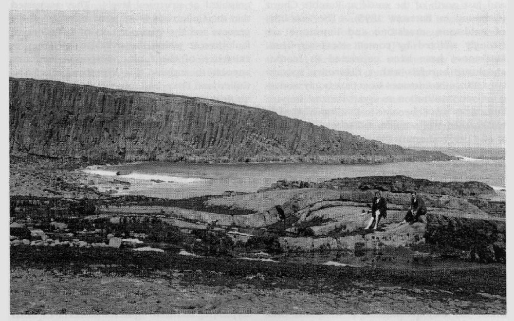
The Cullernose Point to Castle Point GCR site extends for 3.5 km along the Northumberland coast from the promontory of Castle Point south to Cullernose Point
The sill is intruded immediately below the Great Limestone at the base of the Namurian Series, and both sedimentary rocks and sill dip gently eastwards. Cross-dip sections are well exposed at both the southern and northern margins of the GCR site, and along the intervening coastline the upper dip-slope is well exposed on the shore between tide marks. The excellent coastal exposures at Cullernose Point and at Castle Point clearly reveal the contact metamorphosed sedimentary rocks above and below the sill
A number of general papers on the geology of Northumberland with references to the Whin Sill at this GCR site were published in the 19th century (e.g. Winch, 1817; Tate, 1868). The most significant early paper was that of Tate (1871), which provided many illustrations of the intrusive nature of the sill in Northumberland. The intrusive nature was debated for several years until the abundant evidence was collated and presented by Topley and Lebour (1877). E.J. Garwood (in Bateson, 1895) presented a detailed account of the geology of this GCR site. The original geological survey of the Alnwick area was completed between 1871 and 1878 and the six-inch maps were revised between 1921 and 1925, leading to publication of the revised one-inch Sheet 6 (Alnwick) and an accompanying memoir (Carruthers et al., 1930). The later basaltic intrusions and felsic veins and pods at this site were described and analysed by Smythe (1930a) in his paper on the geochemistry of the Whin Sill-complex.
Description
The
South of Cushat Shiel a number of faults intersect the coast, most of which have a trend of east-west or north-east-south-west. The upper surface of the sill is extremely well exposed on the shoreline between tide marks and shows the distinctive pattern of columnar joints perpendicular to the sill margins. At Craster
Immediately south of Craster is another zone of weakness in the sill known as 'Hole o' the Dike' which trends north-east–south-west. The dolerite within this zone is heavily jointed and there is some calcite veining. A few hundred metres farther south is another recessed feature known as 'Black Hole'
Xenoliths of country rock are also common in the sill in the vicinity of Dunstanburgh Castle and just north of the castle at Rumble Churn (Garwood in Bateson, 1895). The xenoliths of sandstone, mudstone and limestone are strongly affected by contact metamorphism. Mudstones have been converted to biotite-andalusite hornfels with a distinctive spotted appearance; sandstones have commonly undergone recrystallization to quartzite and impure limestones have become calc-silicate hornfels with garnet, wollastonite and idocrase (Westoll et al., 1955). Impure limestones tend to show more alteration than pure limestones, as recognized by Randall (1959). Vesicles in the sill that are close to xenoliths commonly contain radiating crystals of quartz (in places amethysts), which are known locally as 'Dunstanburgh diamonds'.
Veins and pods of pink felsic material are particularly abundant around Cushat Shiel. The veins are up to 5 cm in width and the roundish pods are about 2 cm thick and several centimetres across. This felsic material varies in grain size from pegmatitic to cryptocrystalline in which the major components of quartz and feldspar cannot be distinguished. Smythe (1930a), in his extensive study of the Whin Sill-complex, believed this location to have the greatest concentration of felsic material. He also described intrusions of fine-grained basaltic rock at Cullernose Point and Scrog Hill, the latter being heavily altered. The intrusions are just a few centimetres thick and have chilled margins against the normal quartz-dolerite. The intrusion at Cullernose Point contains rare microphenocrysts of augite but is otherwise non-porphyritic. Smythe's analyses showed that these basic intrusions have broadly the same chemical composition as the sill.
Interpretation
Garwood (in Bateson, 1895) produced a field sketch showing the Cullernose Dyke at Swine Den feeding the sill, but Carruthers et al. (1930) were unable to find sufficient field evidence connecting the sill and the dyke. Westoll et al. (1955) discussed the emplacement of the
The felsic pods in the vicinity of Cushat Shiel were described and analysed by Smythe (1930a). He concluded that as crystallization of the sill progressed, the remaining magma became progressively more acidic. The composition of this late-stage assemblage typically comprises small feldspar laths, some orthoclase and quartz. This assemblage forms either a relatively coarse-grained pegmatitic facies, an indeterminate fine-grained assemblage or, when concentrated, 'a crypto-pegmatite in spherulitic form'. Such segregation veins and pods are now recognized in the upper parts of many thick sills as the final product of differentiation.
The fine-grained basaltic intrusions, with chilled margins, are similar in composition to the sill and are therefore not differentiates. Smythe (1930a) argued that they must have been intruded later, 'at a time when the sill had become consolidated and cold'. This observation has potential significance in current debates concerning the relative ages of the sill-complex and the accompanying dyke-swarms.
Conclusions
At the Cullernose Point to Castle Point GCR site, excellent exposures reveal classic features relating to the intrusion and late-stage crystallization of a sill. In addition this site provides a spectacular example of the influence of the