Chapter 6 Craven Basin
P.J. Cossey, N.J. Riley, A.E. Adams and J. Miller
Introduction
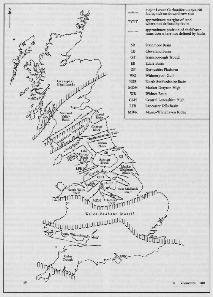
The Craven Basin, which here includes the Bowland Basin of Ramsbottom (1974) and Gawthorpe (1986, 1987a) and the Lancaster Fells Basin of Gawthorpe et al. (1989), is an asymmetric half-graben embracing a number of depositional 'highs' and 'lows' south of the Askrigg Block and South Lake District High (Figure 6.1). The base of the Dinantian succession is not seen and has not been reached by boreholes, but a maximum of at least 2 km of Dinantian strata is known, and gravity modelling and seismic evidence suggest the thickness could be twice this figure (Gawthorpe et al., 1989; Aitkenhead et al., 1992; Kirby et ed., 2000).
To the east of Settle, the boundary between the Askrigg Block and the Craven Basin is largely marked by the Middle Craven Fault. To the west of Settle, although mostly obscured by Upper Carboniferous outcrop, there is geophysical evidence for the existence of a WNW-trending fault boundary as far as Ingleton, where it joins the Dent Fault (Arthurton et al., 1988) and meets the South Lake District High. From here the northern boundary of the basin trends south-westwards to the Carnforth–Lancaster area (Figure 6.1).
The southern margin of the basin is masked by Upper Carboniferous deposits, but thickness and facies variations (Miller and Grayson, 1982; Gawthorpe, 1987a) and geophysical data (Arthurton et al., 1988; Lee, 1988a,b; Fraser and Gawthorpe, 1990; Fraser et al., 1990) suggest that the boundary was a fault at depth beneath the Pendle Monocline ((Figure 6.1); and see Evans and Kirby, 1999; Kirby et al., 2000). This fault separated the Craven Basin from an area of relatively stable basement with a thin Lower Carboniferous succession, known as the 'Central Lancashire High' ((Figure 1.3), Chapter 1; and see Miller and Grayson, 1982).
Outcrop in the area is almost entirely of Carboniferous rocks. Away from the northern margin of the basin, earlier Carboniferous strata are seen mostly in a series of NE–SW-trending anticlines which form part of the Ribblesdale Fold Belt (Figure 6.1). Exposure is generally poor, especially of the fine-grained rocks in the succession. Disused and working quarries provide the best exposures of the limestones, with stream and river sections forming the most important natural exposures, particularly of the mudstones.
History of research
The classic account of the geology of Yorkshire by Phillips (1836) contains the earliest descriptions of the Carboniferous succession in the Craven Pennines. The area was mapped by the [British] Geological Survey in the latter part of the 19th century when the first 'one-inch' (1:63 360) maps were published. An early memoir for the Clitheroe area and the coalfield to the south was published at this time (Hull et al., 1875), but no memoirs for the northern part of the basin were published until later. Further details of the succession were published by Tiddeman (1889, 1890, 1891) and Marr (1899) who focused attention on the knoll reefs of the Cracoe area. Other work at this time included a report of trilobites from the River Hodder section (Woodward, 1894).
Further advances in understanding the geology of the Craven area were made by Hind and Howe (1901), Hind (1903), Wilmore (1906, 1907, 1910, 1912, 1916) and Hind and Wilmore (1918). Although Wilmore (1910) had begun to apply the Avonian zonal scheme of Vaughan to the Craven Basin, further correlations were made by Vaughan himself (Vaughan, 1915, 1916). In the middle years of the 20th century the contributions of four workers stand out. Bisat's work on goniatites led to refinements in the stratigraphy, particularly of the Bowland Shales (Bisat, 1924, 1928, 1933, 1950, 1952). Parkinson (1926, 1935, 1936, 1944, 1950b, 1952a, 1957, 1967, 1968, 1974a) published on the geology of the Clitheroe and Slaidburn areas, with a particular emphasis on the faunas and origin of the Clitheroe knolls. Hudson and various co-workers studied the Carboniferous succession of the Askrigg Block, Craven Basin and the 'transition zone' (see Chapter 5) between these areas. Papers that consider the geology of the Craven area include Booker and Hudson (1926), Hudson (1927, 1933, 1938a,b, 1944b, 1945, 1949), Hudson and Versey (1935), Hudson and Mitchell (1937) and Hudson and Dunnington (1944). It was Hudson (1933) who first introduced the term 'Craven Basin'. The well-preserved echinoderm faunas of the Clitheroe knoll reefs have long attracted interest and were the focus of a series of works by Wright (1928, 1935, 1942, 1943, 1947, 1948, 19501960). Other work at this time includes the contributions of Moore (1930, 1936, 1939, 1941, 1946, 1950, 1952), largely on goniatites and the Bowland Shales; Bray (1927) on the succession between Lothersdale and Cowling; Waddington (1927) on the Stonyhurst area; Gill (1940, 1947) and Black (1940) on aspects of the stratigraphy of the Bowland Shales; and Dunnington (1945) on slump structures in the Embsay Limestone.
Important contributions in the second half of the 20th century have included five memoirs that describe substantial tracts of the basin around Bradford and Skipton (Stephens et al., 1953), Clitheroe (Earp et al., 1961), Settle (Arthurton et al., 1988), Garstang (Aitkenhead et al., 1992) and Lancaster (Brandon et al., 1998). Harrison (1982) reviewed the limestone resources of the area. Other publications on the structure and stratigraphy of the Craven Basin include Moseley (1954) on the Namurian sequence of the Lancaster Fells, Fewtrell and Smith (1978, 1980), Fewtrell et al. (1981a,b) and Riley (1995) mostly on foraminiferal faunas and stratigraphy, and Metcalfe (1980, 1981) on conodont biostratigraphy. Arthurton and Jones (1980) and Riley (1990a) dealt more generally with the Dinantian stratigraphy of the basin, and Brandon et al. (1995) described early Namurian marine bands. A deep borehole from Swinden was described by Charsley (1984). Aspects of the structure of the area have been described by Moseley (1962), Arthurton (1984) and Lee (1988a,b).
Faunas of the area have continued to attract interest and more recent contributions include Westhead (1967, 1979), Donovan and Sevastopulo (1985, 1988), Donovan (1986, 1992) and Donovan and Westhead (1987) on echinoderms; OsmOlska (1968) and Miller (1973) on trilobites; Riley (1982a, 1985, 1987, 1996) on trilobites and ammonoids; Mitchell and Somerville (1988) on corals; and Chapman et al. (1993) on dendroid graptolites.
Contributions on sedimentology include Trotter (1952) on the Namurian sequence, and Black (1952) and Bathurst (1959, 1982) on the origin of the sparry calcite fabrics ('Stromatactis') in the Clitheroe Limestone Formation. The PhD thesis of Barraclough (1983) covered aspects of the sedimentology of the basin, and the origin and development of 'Waulsortian' buildups (also referred to in the literature as 'knoll reefs', 'reef knolls', 'carbonate mud-banks' and 'mud-mounds') has been considered by Miller and Grayson (1972, 1982) and Lees and Miller (1985, 1995). The diagenesis of the Waulsortian was discussed by Miller (1986) and Gillies (1987). Further aspects of the diagenesis of basinal sequences, including dolomitization, were discussed by Addison et al. (1985) and Gawthorpe (1987b). Gawthorpe and Clemmey (1985) described submarine slides within the basin and Lawrence et al. (1987) reviewed the structural development and petroleum potential of the area. The evolution of Pendleian sands in the region has been described by Sims (1988), and aspects of Arnsbergian sedimentation were considered by Johnson (1981) and Martinsen (1990, 1993). Aspects of the tectonic and sedimentary history of the basin have been discussed in papers by Gawthorpe (1985, 1986, 1987a), Gawthorpe and Clemmey (1985), Gawthorpe et al. (1989), Fraser and Gawthorpe (1990) and Kirby et al. (2000).
Stratigraphy
The overall Carboniferous succession in the Craven area, comprising limestones at the base and grits at the top, separated by a series of shales with some interbedded limestone and sandstone was recognized by Phillips (1836). The nomenclature applied to this succession was refined during the early mapping by the [British] Geological Survey when some of the current terms such as 'Bowland Shales' and 'Pendleside Limestone' were introduced. The knoll reefs were named by Wilmore (1907) and correlations to other areas were made by Wilmore (1916) and Vaughan (1915, 1916). The zonation of the Bowland Shales was established by Bisat (1924).
Earp et al. (1961) described the stratigraphy for the Clitheroe area and this formed the basis for later modifications by Fewtrell and Smith (1980). Acquisition of further data allowed a revision of the stratigraphy of the Worston Shale Group and the recognition of four unconfor-mities within the succession (Riley, 1990a). For the north and west of the Craven Basin, the memoirs of Arthurton et al. (1988), Aitkenhead et al. (1992) and Brandon et al. (1998) contain the most recent reviews of stratigraphical nomenclature and correlation, and their data is incorporated into the summary stratigraphical table (Figure 6.2).
George et al. (1976), in their review of Dinantian stratigraphy, chose the Chatburn Bypass road cutting for the type section of one of their new regional stages, the Chadian Stage. Although this has subsequently been shown to be an unfortunate choice (see Chatburn Bypass GCR site report, this chapter), the stage and its type section have yet to be replaced.
Geological setting
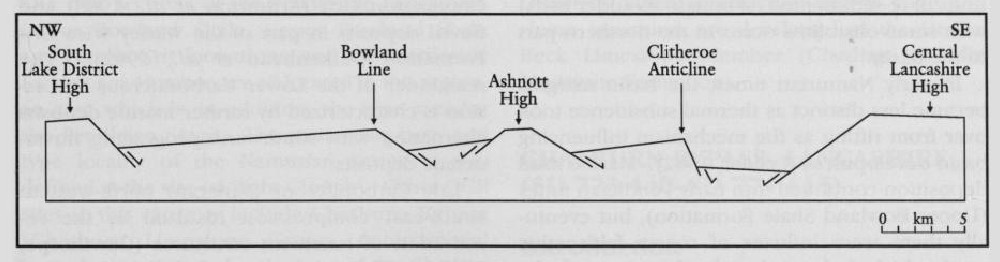
The Craven Basin is an asymmetrical half-graben located between the Askrigg Block and South Lake District High to the north and north-west, and the Central Lancashire High to the south, although the lateral extent of the latter is uncertain. Within the basin are a number of depositional highs and lows probably controlled by intrabasinal fault blocks. The largest of these is the Bowland High which separates the Lancaster Fells Basin to the north-west from the Bowland Basin to the south-east (Figure 6.1). A cross-section showing the possible arrangement of these basement 'tilt-blocks' separated by major active faults during Viséan times is shown in (Figure 6.3). The geological history of the Askrigg Block 'transition zone' is described elsewhere (see Chapter 5).
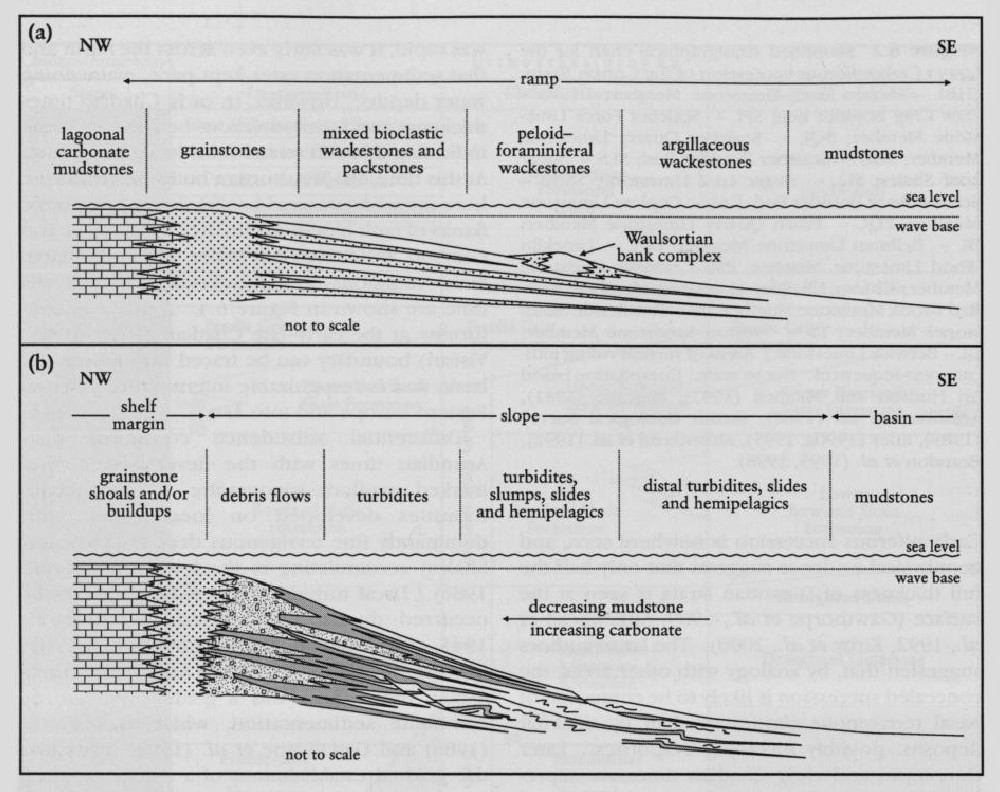
The geological history of the Craven Basin has been reviewed by Gawthorpe (1986, 1987a), Arthurton et al. (1988), Gawthorpe et al. (1989), Riley (1990a), Aitkenhead et al. (1992) and Brandon et al. (1998). The base of the Carboniferous succession is nowhere seen, and geophysical evidence suggests that only half the full thickness of Dinantian strata is seen at the surface (Gawthorpe et al., 1989; Aitkenhead et al., 1992; Kirby et al., 2000). The latter authors suggested that, by analogy with other areas, the concealed succession is likely to be composed of basal terrigenous clastics overlain by tidal-flat deposits, possibly including evaporites. Later Courceyan and early Chadian times are represented by a thick succession (up to 3 km) of fairly uniform dark muddy limestones interbedded with calcareous shales. These were deposited on a southerly dipping ramp (Gawthorpe, 1986). Little variation in thickness or facies is apparent in the exposed part of this succession, suggesting that although subsidence was rapid, it was fairly even across the basin and that sedimentation rates kept pace, maintaining water depths. However, in early Chadian times thickness and facies variations become apparent indicating that differential subsidence had begun. At this time, the Waulsortian buildups (regarded here as carbonate mud-banks) developed on the flanks of fault blocks within the basin (Miller and Grayson, 1982; Lees and Miller, 1985). Probable facies variations on the carbonate ramp at this time are shown in (Figure 6.4). A major unconformity at the early-late Chadian (Tournaisian–Viséan) boundary can be traced throughout the basin and is recognizable internationally across Eastern Europe and into Asia.
Differential subsidence continued into Arundian times with the development of a marked sea-floor topography. Minor unconformities developed on local highs, with dominantly fine terrigenous deposits (Worston Shales) accumulating in the lows (Gawthorpe, 1986). Local turbidites and sedimentary slides occurred during this interval (Dunnington, 1945; Gawthorpe and Clemmey, 1985; Gawthorpe, 1986). From late Arundian to early Asbian times there was a gradual increase in carbonate sedimentation, which Gawthorpe (1986) and Gawthorpe et al. (1989) related to the gradual establishment of a carbonate shelf margin along the southern side of the Askrigg Block. Much of the basinal area was described as a slope environment by Gawthorpe (1986) and facies variations are shown on (Figure 6.4). The late Asbian to Brigantian interval was marked by renewed tectonism. The deep basin was characterized by background mud sedimentation (Lower Bowland Shale Formation) with some siliciclastic and carbonate turbidites (e.g. Pendleside Sandstones Member), but major units of re-sedimented carbonate (boulder beds) with some olistoliths occur in the northern part of the basin.
In early Namurian times, the basin margins became less distinct as thermal subsidence took over from rifting as the mechanism influencing basin development (Leeder, 1982). Marine mud deposition continued into early Pendleian times (Upper Bowland Shale Formation), but eventually there were influxes of coarse feldspathic sand which led to the development of the Pendle, Warley Wise, Grassington and Brennand grits. Brought in by a major river flowing from the north or north-east, and deriving sediment from eastern Greenland, these sediments were initially deposited in marine conditions (Sims, 1988). However, with the progression of time, deltas prograded southwards such that delta-top sediments are recognized in parts of the Grassington Grit (Arthurton et al., 1988) and fluvial deposits in part of the Warley Wise Grit Formation (Aitkenhead et al., 1992). The remainder of the Lower Carboniferous succession is characterized by further marine deposits alternating with southwards-prograding fluvio-deltaic deposits.
Late Carboniferous (Variscan) north-west to south-east compression resulted in the reactivation of basement structures (Gawthorpe, 1987a). This subsequently led to a period of basin inversion, which caused the development of a series of en échelon folds (Ribblesdale Fold Belt), the reversal of throws on normal faults and the development of local thrust faults (Corfield et al., 1996).
GCR site coverage
The choice of GCR sites in the Craven Basin reflects key episodes in the structural, stratigraphical and palaeogeographical evolution of the basin during Lower Carboniferous times. Their location is illustrated on (Figure 6.1). The sites can be conveniently subdivided into three groups.
The first of these groups includes sites of outstanding stratigraphical importance, either because they contain the type section of a particular stratigraphical interval (or intervals) or because they contain an especially thick or complete succession. Most of these sites are located away from the basin margin. Two sites stand out as being especially significant on account of the range of stratigraphy that is represented and because of their great size. The first of these, the River Hodder GCR site, provides a classic section through arguably the finest and thickest deep-water marine and hemi-pelagic sequence of Viséan (Chadian–Asbian) age in Britain, and includes the type sections of the Hodder Mudstone Formation, the Limekiln Wood Limestone and Chaigley Limestone members, and the Hodderense Limestone Formation. Key sections of the younger Pendleside Limestone and Lower Bowland Shale formations are also represented at the site. The second, at Pendle Hill (a composite GCR site comprising the Little Mearley Clough, Little Mearley–Limekiln and Light Clough GCR sites), offers an extensive section ranging from the Hodder Mudstone Formation through to the Pendle Grit Formation (Holkerian–Pendleian) and is one of the classic sites of late Dinantian and early Namurian ammonoid (goniatite) biostratigraphy. The type sections of the Pendleside Limestone, Lower Bowland Shale, Upper Bowland Shale and Pendle Grit formations, and the Pendleside Sandstones Member, are all located in this region, an area which is, in addition, the type area for the Pendleian Stage. The stratotypic base and type locality of the Namurian Series is also defined at the site (at Light Clough). Other GCR sites in this category include Chatburn Bypass (Chatburn Limestone Group, controversial boundary stratotype for the base of the Chadian Stage); Holywell Bridge (Haw Bank Limestone-Skipton Castle Limestone, Courceyan–Chadian); and Saleswheel (Warley Wise Grit Formation, Sabden Shales Formation, candidate as boundary stratotype for the base of the Arnsbergian Stage).
The second group includes sites located towards the basin margin where relatively thin and/or incomplete successions are developed, and which are commonly punctuated by non-sequences and/or debris beds of regional stratigraphical and tectono-sedimentary significance. These include Haw Crag (Chadian–Arundian, unconformity between the Thornton Limestone Member (Clitheroe Limestone Formation) and the Worston Shales (Hodder Mudstone Formation) and the Haw Crag Boulder Bed); Clints Quarry (Holkerian–Brigantian, unconformity between the Worston Shales (Hodder Mudstone Formation) and the Pendleside Limestone Formation, limestone conglomerate, coral faunas); Hambleton Quarry (?Holkerian–Asbian, Skibeden Shales with Limestones (Hodder Mudstone Formation), the Draughton Limestone with Tiddeman's Breccia and the Draughton Shales (Pendleside Limestone Formation)); Dowshaw Deff Quarry (Arundian–Holkerian, unconformity within the Hodder Mudstone Formation between the Embsay Limestone Member and the Twiston Sandstone Member); and Artle Beck (Arnsbergian, unconformity between the Roeburndale and Wards Stone Sandstone formations, plus basin-margin thickening of the Eumorphoceras yatesae Marine Band).
A third group comprises sites of particular sedimentological and/or palaeontological interest. Among these are Coplow Quarry, Salthill and Bellmanpark Quarries, and The Knolls GCR site — a complex suite of sites close to Clitheroe which illustrate a range of features associated with the development of Waulsortian' mud-bank facies in the Chadian Clitheroe Limestone Formation and which contain rich echinoderm faunas. A further site in this category is Sykes Quarries where spectacular gravity slide and slump structures are developed in the Hetton Beck Limestone Member (Chadian, Hodder Mudstone Formation).
References