Robin's Wood Hill Quarry, Gloucestershire
M.J. Simms and N. Chidlaw
Introduction
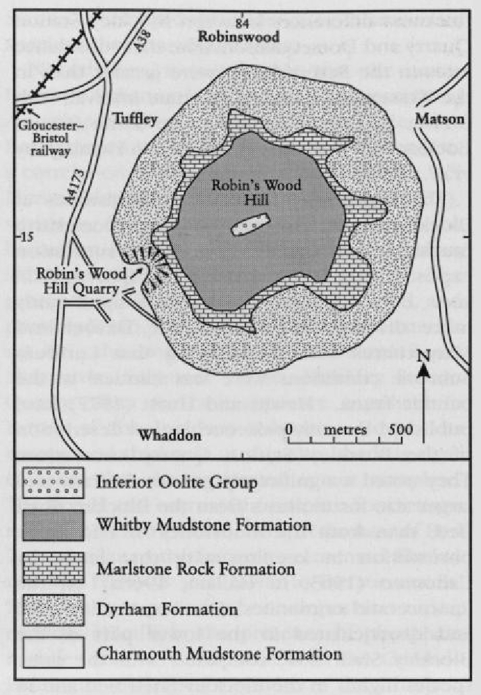
The Robin's Wood Hill Quarry GCR site comprises a large quarry, disused for several decades, excavated into the south-western flank of Robin's Wood Hill overlooking Tuffley, a suburb of Gloucester
Despite his extensive research into the geology of this area, Robin's Wood Hill received only passing mention in Richardson's field guide to the geology of Cheltenham (1904). The site formed the subject of an excursion report (Watts, 1928), in which a general account of the fossil fauna and its palaeoecology was given, but the lithological succession otherwise remained undescribed until an excursion report by Ager (1955). In this he estimated the ammonite zone ranges for the section. A general account of the site was published by Dreghorn (1967). The site formed part of a major investigation by Palmer (1971, 1973) who described the stratigraphical succession in detail and attempted correlation with the succession in another disused pit, at Stonehouse
Further details of the Lower Pliensbachian stratigraphy at this site were published by Phelps (1985), and well-preserved crinoid material from near the base of the Upper Pliensbachian succession was figured by Simms (1989). The Upper Pliensbachian succession at Robin's Wood Hill Quarry also formed part of a broader investigation into Upper Pliensbachian sedimentation patterns of the Severn Basin (Simms, 1990a) during which some revisions of the biostratigraphy established by Palmer (1971) were made. The most recent investigation of the site was by Chidlaw (1987) who logged the succession in more detail than that of earlier accounts.
Description
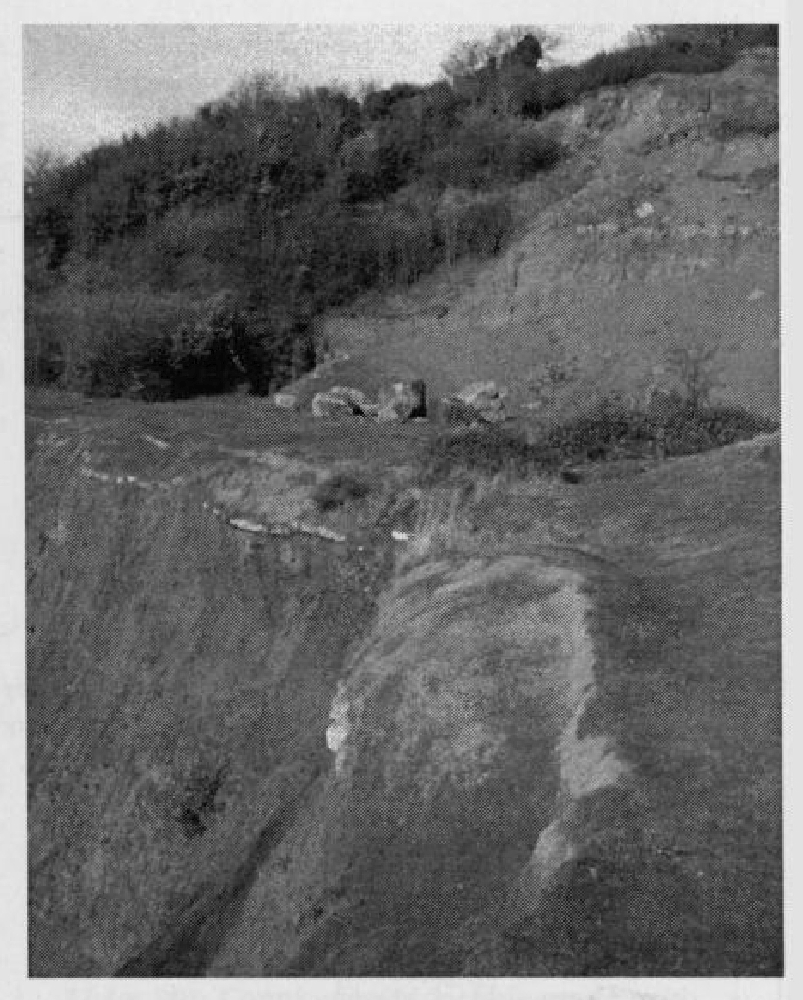
Robin's Wood Hill Quarry has been excavated at two levels, described as the 'upper quarry' and 'lower quarry'
| Thickness (m) | |
| TOARCIAN STAGE | |
| Tenuicostatum Zone (presumed) | |
| D: Clay, fawn-brown, soft, sticky. | 0.90 (seen) |
| C: Clay, mottled, pale-grey/orange, soft, sticky. This has a diffuse contact with Unit D above and mails, and overlies by a few cm, the irregular top of Unit B below. | 0.30 |
| UPPER PLIENSBACHIAN SUBSTAGE | |
| Spinatum Zone (presumed) | |
| B: Clay, mottled, pale-grey/orange/red-brown, soft, sticky, containing weathered clasts of Unit A; some are up to 0.35 m across, angular and only slightly iron-stained; others are reddish-brown and friable, 3–4 cm across, subangular and of high sphericity. The contact with units above and below is irregular, with mammilated limonite nodules 2–5 cm across locally present on the upper surface. | 0.45 |
| A: Limestone, massive, well jointed, greenish-grey, bioclastic, with abundant ferruginous ooids. Belemnites and bivalves common, with some rhynchonellid brachiopods. This bed is lithologically identical to Bed 37 (= 16c of Palmer, 1971) of the main section reproduced below. | 1.50 (seen) |
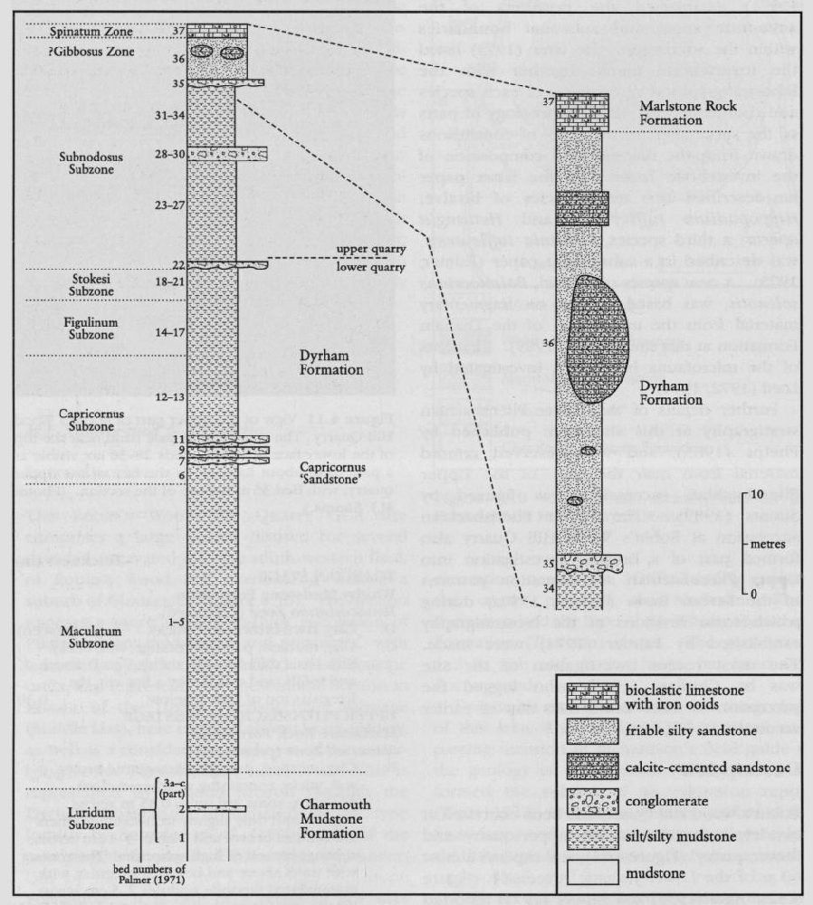
The descriptions and bed numbers of the units within the main quarry section, as shown below, and depicted in Figure 4.12, are based largely on the work of Chidlaw (1987), but follow the lithostratigraphical divisions of Cox et al. (1999). The bed numbers of Palmer (1971) are given in parentheses.
| UPPER PLIENSBACHIAN SUBSTAGE | Thickness (m) |
| Spinatum Zone | |
| 37 (= 16c): Limestone, massive, rubbly weathering, brownish-grey, bioclastic, with abundant ferruginous ooids. Scattered shelly fauna including belemnites, rhynchonellids and bivalves. Pleuroceras spinatum and Amaltheus cf. subnodosus recorded by Palmer (1971). | 0.33 |
| Margaritatus Zone, Subnodosus to ?Gibbosus subzones | |
| 36 (= 16b): Sandstone, yellow-buff weathering, ferruginous, friable, micaceous, fine, silty. Locally between 1.8 m and 3.3 m above the base of the unit are hard, calcite-cemented, irregular 'doggers' up to about 1.5 m thick and 3 m across, with smaller ellipsoidal calcite concretions below the Jogger horizon and more laterally extensive, though discontinuous, bands of calcite-cemented sand above the doggers. Abundant bioturbation, although trough cross-lamination and dish structures locally present. Fossils scattered and only well-preserved in cemented units, but including belemnites, bivalves and debris of the crinoid Balanocrinus solenotis. Simms (1990a) recorded Amaltheus subnodosus up to 2.6 m above the base of the unit. | 4.87 |
| 35 (= 16a): Conglomerate, irregular, pebble-to cobble-grade. Clasts mostly flat-lying discoidal or ellipsoidal, of pale-grey siltstone. Matrix of yellow-brown mudstone within abundant fine bioclastic debris. Ager (1954) recorded Gibbirhynchia micra from the clasts. | 0.18 |
| 34 (= 15 part): Siltstone, yellow-brown, sandy, micaceous. Local indistinct and bioturbated planar laminations. | 0.20 |
| 33 (= 15 part): |
1.80 |
| 32 (= 15 part): |
3.33 |
| 31 (= 15 part): Mudstone, dark blue-grey, clayey, micaceous, silty. Grades up into Bed 32 above. | 3.00 |
| 30 (= 14 part): Congomerate, flat pebble- to cobble-grade, with siltstone clasts set in a green-grey, sandy micaceous silt matrix. | 0.12 |
| 29 (= 14 part): Limestone, hard, pale-grey, bioclastic, with occasional ferruginous ooids in top 0.02 m. Undulating base and top. | 0.24 |
| 28 (= 14 part): Conglomerate, pebble- to cobble-grade. Discoidal clasts of hard blue-grey siltstone with ferruginous rind in a matrix of green-grey mudstone with abundant bioclastic debris. Irregular base. | 0.22 |
| Stokesi Subzone | |
| 27 (= 13 part): |
0.36 |
| 26 (= 13 part): |
1.64 |
| 25 (= 13 part): |
4.33 |
| 24 (= 12): Siltstone, hard, shelly, micaceous. Amaltheus stokesi and Lytoceras fimbriatum recorded by Palmer (1971). | 0.56 |
| 23 (= 11): Clay, blue-grey, silty, passing up into dark greenish-grey, planar-laminated, clayey micaceous silt. Floor of upper quarry lies 0.2 m above the base of this unit on the south side of the quarry | 3.27 |
| 22 (= 10): Conglomerate, pebble-grade, with hard, discoidal/ellipsoidal, blue-grey siltstone clasts in a matrix of grey-green mudstone with abundant coarse bioclastic debris and large thick-ribbed bivalves. The upper 0.15 m is deeply weathered, with friable clasts and a 0.05 m-thick reddish-orange layer at the top. Erosion surface contact with Bed 21. Amaltheus wertheri and Pagophylloceras recorded by Phelps (1985). | 0.35 |
| 21 (= 9g part): |
0.25 |
| 20 (= 9g part): Siltstone, blue-grey, sandy, micaceous, massive, with pea-sized siderite nodules. Broken thin-shelled bivalves. | 0.04 |
| 19 (= 9g part): |
3.52 |
| 18 (= 9f part): Siltstone, discontinuous, pale grey, commonly with abundant remains of Balanocrinus gracilis. Bivalves common and specimens of Amaltheus bifurcus and A. wertheri. | 0–0.08 |
| LOWER PLIENSBACHIAN SUBSTAGE | |
| Davoei Zone, Figulinum Subzone | |
| 17 (= 9f part): |
0.66 |
| 16 (= 9e): Siltstone, pale blue-grey, indurated, planar- and cross-laminated, micaceous, with broken shell debris and small siderite concretions. Oistoceras? angulatum recorded by Phelps (1985). | 0.10 |
| 15 (= 9d): |
5.49 |
| 14 (= 9c): Siltstone, blue-grey, indurated, wavy laminated, micaceous, with burrow mottling. | 0.08 |
| Capricornus Subzone | |
| 13 (= 9b part): |
6.62 |
| 12 (= 9b part): |
1.14 |
| 11 (= ?): Iron-stained pebble conglomerate, with siltstone clasts in a siltstone matrix. | 0.08 |
| 10 (= ?): |
0.80 |
| 9 (= ?): Iron-stained pebble-grade conglomerate, with siltstone clasts in a siltstone matrix. | 0.04 |
| 8 (= ?7): |
0.80 |
| 7 (= ?): Pebble conglomerate, with siltstone clasts in a siltstone matrix. Aegoceras capricornus recorded by Phelps (1985). | 0.05 |
| 6 (= 6): Siltstone, pale grey, indurated, clayey, micaceous, forming prominent hard band. Together with beds 7 and 8 this represents the 'Capricornus Sandstone' of Palmer (1971). | 1.65 |
| Maculatum Subzone | |
| 5 (= 5 part): Siltstone, pale grey, indistinctly laminated, clayey, micaceous. | 1.14 |
| 4 (= 5 part): |
5.37 |
| 3 (= 4): Siltstone, pale grey, planar laminated, clayey, micaceous. | 0.19 |
| 2 (= 3c part): |
10.5 |
| 1 (= 3c part): |
1 (seen) |
| 3c: (part): Shales, grey, silty, with ferruginous nodules. | c. 2 |
| 3b: Clay, blue, sticky, with ironstone nodules. Androgynoceras sparsicosta recorded by Phelps (1985) and Aegoceras maculatum recorded by Palmer (1971). | 1.82 |
| Ibex Zone, Luridum Subzone | |
| 3a: Shales, grey, silty, grading up to dark-grey clay. | 1.23 |
| 2: Shales, hard, grey, sandy ?Beaniceras luridum recorded by Phelps (1985) and Palmer (1971). | 0.30 |
| 1: Shales, grey, with nodules. | c. 3 |
The floor of the lower quarry lies in a series of grey mudstones and silty mudstones of the
Grey silty mudstones with several indurated units and siltstone clast conglomerate bands form the near-vertical face of the lower quarry, more than 20 m high. This encompasses Bed 2 to the lower part of Bed 23 of this account (Palmer's Bed 4 to the lower part of Bed 11), corresponding to much of the
The lowest 8 m or so of the Stokesi Subzone is exposed at the top of the lower quarry, with the upper quarry exposing the remainder of the
The
Interpretation
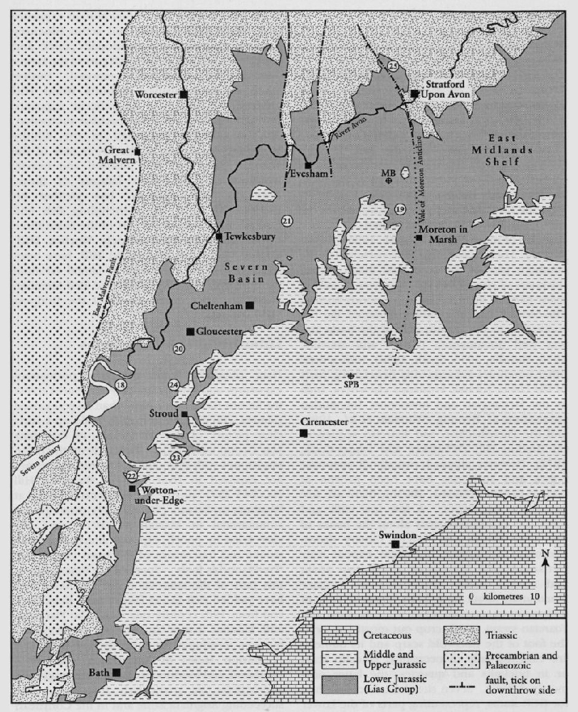
Palmer (1971) was the first to establish a detailed lithostratigraphy for the Robin's Wood Hill Quarry GCR site and succeeded in identifying the principal biostratigraphical boundaries. Where ammonites could not be found in the succession these boundaries were based partly on lithostratigraphical cross-correlation with the Stonehouse Brick and Tile Quarry, 10 km farther to the south
Palmer (1971) assigned 7.7 m of silty mudstones of the
Higher in the succession, Ager (1955) and Palmer (1971) interpreted the presence of Gibbirhynchia micra in Bed 35 as evidence for the Spinatum Zone. Palmer (1971) failed to find evidence for the Gibbosus Subzone below Bed 35 at Robin's Wood Hill Quarry. However, Amaltheus subnodosus occurs up to 2.6 m above the base of Bed 35 (Simms, 1990a) and hence the Gibbosus Subzone must lie above this level. Its presence has yet to be proven at this site, although it is known elsewhere in the northern Cotswolds. The Spinatum Zone is, therefore, probably confined to Bed 37 at the very top of the quarry, and Cox et al. (1999) included beds 35 and 36 within the
As the most extensive inland exposure of the Pliensbachian Stage, incorporating the type section of the
Palmer (1971) also attempted correlation of the Robin's Wood Hill Quarry succession with those in the Stowell Park Borehole (Green and Melville, 1956). More recent work has helped to define formation boundaries within the succession. Sumbler et al. (1999) designated this as the type section of the
Overall similarities between the Robin's Wood Hill Quarry, Stowell Park Borehole and the Dorset coast successions, particularly in the general coarsening upwards through the sequence, reflect a regional (western Europe) shallowing that is evident in many Pliensbachian sequences (Hallam, 1981; Hesselbo and Jenkyns, 1998). More detailed lithostratigraphical correlation of marker bands between Robin's Wood Hill Quarry and the Dorset coast, located as they are in separate basins, must be regarded as tentative at best. For example, the Capricornus Sandstone, the most distinctive marker band in the Lower Pliensbachian successions of the Severn Basin has no lithostratigraphical correlative in the Green Ammonite Mudstone Member of the Wessex Basin (Hesselbo and Jenkyns, 1995), nor at Napton-on-the-Hill on the East Midlands Shelf (Callomon in Hallam, 1968a). The Subnodosus Sandstone Member (Simms, 1990a) in the upper part of the
The succession exposed at Robin's Wood Hill Quarry has proven invaluable in understanding patterns and controls on sedimentation in the Severn Basin during early and mid Jurassic times. The apparent absence of the Subnodosus Sandstone Member at Robin's Wood Hill Quarry (Palmer, 1971), was interpreted as a manifestation of uplift along a WNW–ESE axis, probably associated with movement on a basement fault close to Robin's Wood Hill late in Subnodosus Subzone times. Evidence of intermittent uplift on this axis imparting a gentle northward dip of the strata below the
Chidlaw (1987) disagreed with this interpretation, suggesting that lithological marker bands used by Palmer (1971) and Simms (1990a) for correlation within the Severn Basin were confined to individual sub-basins. Another possibility is that the Subnodosus Sandstone Member, far from being absent at Robin's Wood Hill Quarry, may in fact be represented in part by the thick silty sandstone of Bed 36. Sumbler et al. (2000) suggested that differential subsidence and intermittent truncation across sedimentary highs at times of eustatic lowstand, rather then any uplift, was the principal control on sedimentation erosion.
Conglomeratic horizons are developed at several levels throughout the succession at this site. Typically the clasts are of siltstone, evidently derived from the sediments beneath, and commonly are of a flattened discoidal shape. Palmer (1971) correlated some of these beds across the Severn Basin and possibly beyond, indicating widespread episodes of erosion and reduced sedimentation, which he (Palmer, 1973) attributed to periods of shallowing. The relative abundance of these episodes, represented by the conglomeratic horizons, at Robin's Wood Hill Quarry may indicate proximity to an area of uplift, and hence some may be of local distribution. Chidlaw (unpublished observations) has noted evidence for prolonged weathering, with leaching and concentration of iron oxide, at the top of Bed 22 in the
Robin's Wood Hill Quarry has been the site of a number of significant palaeontological discoveries. The discovery of Amaltheus subnodosus up to 2.6 m above examples of Gibbirhynchia micra in Bed 35 extends the known range of this brachiopod, which formerly was recorded only from the uppermost Gibbosus Subzone and lower Spinatum Zone (Alter, 1954). The occurrence of Tetrarhynchia dunrobinensis in Bed 8 of Palmer (1971, 1973) extends its geographical range from its previously known distribution in Yorkshire and Scotland. Palmer (1973) interpreted the abundance of large filter-feeding bivalves in the coarser units of the
Conclusions
Robin's Wood Hill Quarry provides the finest section through the Pliensbachian Stage, in particular the