Heol Senni Quarry, Powys
W.J. Barclay
Introduction
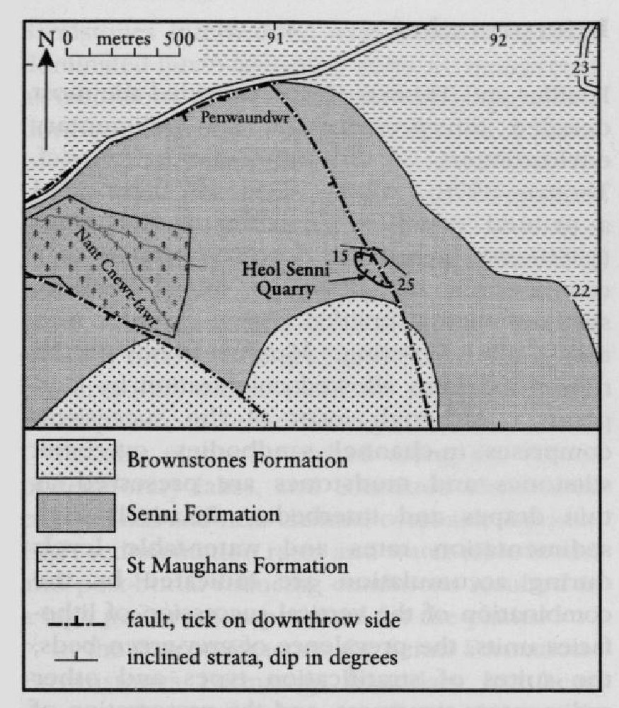
Heol Senni Quarry lies on the north-east face of Fan Bwlch Chwyth
Description
The quarry was first described by Edwards et al. (1978) for a field guide produced for a symposium on the Devonian System. These authors summarized the lithologies, palaeobotany and palynology. During the symposium field visit to the quarry, fossil fish remains (Althaspis senniensis)were discovered (Loeffler and Thomas, 1980). Almond et al. (1993) gave a brief description of the quarry. The site's importance as a fossil fish locality is detailed in the GCR fossil fishes volume (Dineley and Metcalf, 1999).
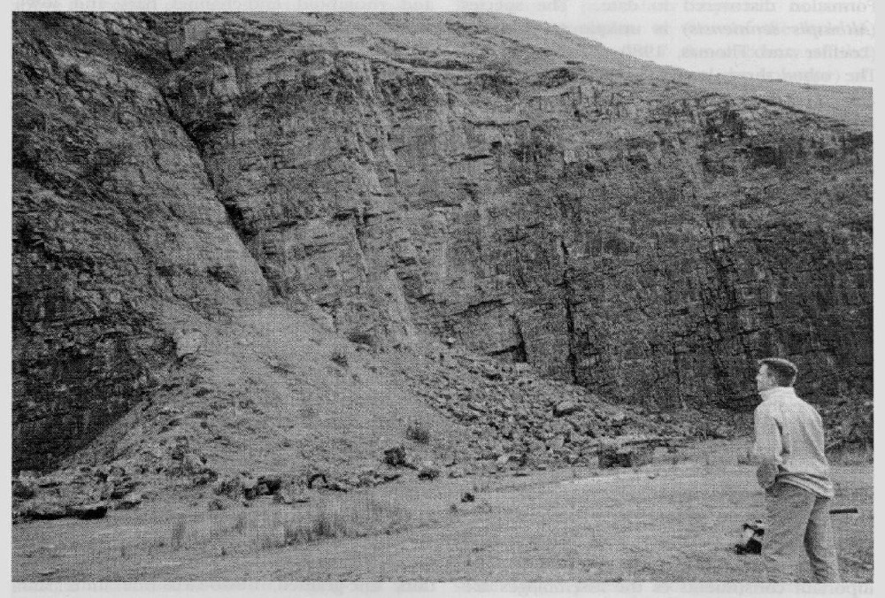
The succession comprises grey-green sandstones, with minor siltstones, mudstones and intraformational conglomerates. The beds dip generally about 5° to the SSW. A NW-trending fault, which throws down to the west, cuts the south-east corner of the quarry, producing a steeper (c. 25°) south-west dip in its footwall, with dips of 5° in a minor hanging-wall anticline. There is no obvious cyclicity to the arrangement of the facies. The sandstones are fine- to medium-grained, lithic arenites and are generally massive, but have low-angle cross-bedding and parallel lamination. The latter is defined by grain size, and mica and carbonaceous concentrations. Some large-scale planar and trough cross-bedding is also evident. The finer-grained sandstones are ripple cross-laminated and linguoid ripple marks are present on some bedding surfaces. The sandbodies overlie erosion surfaces, with lenses of intraformational conglomerates at their base. The conglomerates, most of which are calcitic, contain grey-green siltstone intraclasts up to 450 mm in length and rolled calcrete nodules. No exotic pebbles are recorded. Some sandstone beds are rich in mica and show primary current lineation. Shredded plant debris is also common. Soft-sediment deformation structures are prominent and include a laterally persistent ball-and-pillow unit and large-scale slump folds. The thin mudstone interbeds are mostly grey-green and blue-grey, but red-brown siltstones, some containing calcrete nodules, are present towards the top of the exposed succession. Some of the mudstones have sandstone-filled desiccation cracks.
The quarry is one of only four localities to have yielded fossil fish remains in the
Plant fragments are common (Edwards et al., 1978). Vascular plant axes several centimetres long, cf. Sawdonia and cf. Cooksonia are recorded. Edwards et al. (1978) recorded well-preserved miospore assemblages from blue-grey siltstone beds. One assemblage from a fissile bed near the top of the succession contains large numbers of distally sculptured Emphanisporites specimens and numerous examples of Apiculiretusispora. Thomas (1978) recognized over fifty taxa of dispersed miospores. The important constituents of the assemblages are listed by Edwards et al. (1978).
Interpretation
Loeffler and Thomas (1980) provided the most detailed interpretation of the sedimentary environments of the
The in-channel facies recognized include channel lags, channel-fill deposits, units formed by the migration of linguoid, transverse, lateral and rhomboid mid-channel bars and low-amplitude sand waves, bar delta wedges and bar top sequences. Thick, multi-storey sand-bodies containing interbeds and/or lenses of intraformational conglomerate that overlie basal erosion surfaces imply repeated channel superposition, filling and excavation. Many channel units are draped by thin mudstones deposited from suspension during waning flood stages. Local, rapid, channel shifting and complete or partial channel abandonment was common. Ponding of flood waters occurred in channel cutoffs and (between stages) in parts of the secondary and tertiary distributaries of the active channel network. This local ponding, combined with decomposition of plant material (with the subsequent lowering of redox potentials), and the presence of reworked calcrete glaebules and calcitized plant fragments, giving high pH and bicarbonate ion concentrations, resulted in the calcification of many channel-lag intraformational conglomerates.
The extra-channel and floodplain sediments comprise proximal and distal crevasse-splay deposits, some possible levee sediments, and thin, fine-grained, fluvio-lacustrine units laid down in temporary floodplain lakes. Sandstones interbedded with these mudstone-dominated fluvio-lacustrine units are interpreted as incursions of crevasse-splay sands deposited during river-avulsion episodes. The Heol Senni pteraspid may well have been carried from its habitat in the main channel system and deposited within a floodplain lake or channel-fill mud unit during one such flood event. Strongly reducing post-depositional conditions are indicated for most of the fluvio-lacustrine sediments by their typically blue-grey to grey-green colour, and the preservation within them of pyrite nodules, macroplant cuticles and miospores.
Vascular plants flourished along the shores of temporary lakes, and colonized abandoned channel-fills and near-channel overbank deposits. High sedimentation rates and water-table levels, and post-burial reducing conditions resulted in a high preservation potential for the plants.
In the Brecon Beacons the
The
Loeffler and Thomas (1980) and Dineley (19991) provided the most comprehensive stratigraphical reviews. The palynomorphs indicate a late Lochkovian to Pragian age and the pteraspid Althaspis senniensis is a late Dittonian to Breconian form. The Primrose Hill pteraspid Rhinopteraspis dunensis occurs in the type area of the Siegenian (Pragian) stage. This, combined with the Heol Senni pteraspid and the palynomorphs, indicates that the Lochkovian–Pragian boundary lies within the
Conclusions
Heol Senni Quarry is of great importance for the sedimentological and stratigraphical information it provides. It has the thickest exposed inland vertical succession of