The British Paleogene Volcanic Province — Ailsa Craig Geological Conservation Review site
C.G. Smitha, R.M.L. Wignallb*
aBorder Geo-Science, United Kingdom
bScottish Natural Heritage, Silvan House, 231 Corstorphine Road, Edinburgh EH12 7AT, Scotland, UK
*Corresponding author: Rachel Wignall [Rachel.Wignall@nature.scot]
Abstract
The small peralkaline microgranite intrusion that forms the island of Ailsa Craig in the Firth of Clyde represents the southern-most intrusion of the British Paleogene Volcanic Province (BPVP) within Scotland. The granitic rocks of Ailsa Craig, famous for their use in making curling stones, are thought to be the result of fractionation from a mantle-derived basic magma with no crustal contamination. The rocks of Ailsa Craig also contain the comparatively rare alkaline ferromagnesian minerals riebeckitic arfvedsonite, hedenbergite-acmite and aenigmatite. These factors make the Ailsa Craig intrusion unique in the BPVP. The distinctive ‘spotty’ appearance of the Ailsa Craig granites, which is invaluable as a tracer in establishing Pleistocene glacial transport, results from the close association of ferromagnesian minerals with drusy cavities. This suggests that, unlike the more common dark minerals, they formed late in the cooling and crystallisation history of the magma.
Ailsa Craig was selected as part of the Geological Conservation Review network covering the rocks of the British Paleogene Volcanic Province, which for historic reasons, is known as the ‘Tertiary Igneous’ GCR block. Site descriptions of the GCR sites Tertiary Igneous block are contained in the 4th published GCR volume (Emeleus and Gyopari, 1992). Ailsa Craig GCR site was, however, omitted for reasons unknown. A full GCR site description for Ailsa Craig is, therefore, provided in this paper in order to complete the published description of the Tertiary Igneous GCR block.
1 Introduction
1.1 The Geological Conservation Review
Great Britain contains an unrivalled variety of rocks, minerals, fossils and landforms that provide a geological record of a large part of the Earth's long history. Studied by generations of geologists, there is a great wealth of well-documented geological and geomorphological sites which have provided international and national benchmarks for many aspects of scientific study.
Following earlier attempts to catalogue and record sites for geoconservation in the post-war years (Burek and Prosser, 2008; Prosser, 2013a, b), the Geological Conservation Review (GCR) was launched by the Nature Conservancy Council in 1977 to assess and document the most important parts of Great Britain’s geological heritage for conservation protection (Wimbledon et al., 1995; Ellis et al., 1996; Ellis, 2011). At the time this was the first systematic selection and documentation of any country's best Earth science sites. The minimum criterion for GCR site selection is that sites should offer the finest and/or the most representative features for illustrating a particular aspect of geology or geomorphology. As a result GCR sites are considered to be of national scientific importance at minimum, and many of these include features regarded as ‘classic’ or ‘unique’ sites of international importance. Additional criteria are that there should be a minimum of duplication of interest between sites, and that it should be possible to conserve sites in a practical sense (Ellis et al., 1996).
The GCR is divided into ‘blocks’, which are networks of sites within a portion of the geological column, or a geological, palaeontological or mineralogical topic. There are currently over 3000 GCR sites, selected for over 100 blocks covering the entire range of the geological and geomorphological features of Great Britain. GCR site blocks are published in volumes containing one or more blocks, and each GCR site report is a justification of the particular scientific interest in a locality, of its importance in a British or international setting, and ultimately of its worthiness for conservation. The aim of the GCR series is to provide a public record of the features of interest in sites that have been notified or are being considered for notification as Sites of Special Scientific Interest (SSSIs). It will be used by the Joint Nature Conservation Committee, Natural Resources Wales, Natural England and Scottish Natural Heritage in carrying out their conservation functions (Brown et al., 2018).
The GCR records the current state of knowledge of the key Earth science sites in Great Britain, however it is constantly under review with sites being added or removed as scientific knowledge evolves or where a new or better site is identified. Where published GCR blocks are reviewed, this may mean publication of some additional GCR site reports as stand alone accounts. This site report for the Ailsa Craig GCR site is one such report that was omitted from the original GCR volume ‘British Tertiary Volcanic Province’ (Emeleus and Gyopari, 1992).
1.3 The British Paleogene Volcanic Province and the Tertiary Igneous GCR block
During the Paleocene and early Eocene (c. 63–52 Ma), the north-west British Isles was the site of intense igneous activity which accompanied continental separation and lithospheric thinning during the early stages of the opening of the North Atlantic. Volcanism in Great Britain was most vigorous in the Inner Hebrides and adjoining north-west Scotland but extended to southern Scotland, north-east England and the Outer Hebrides. Intrusions of similar age also occur in north-east Ireland, North Wales, the English Midlands and in the Bristol Channel centred on Lundy. The region encompassing this igneous activity is known as the British Palaeogene Volcanic Province (BPVP) or British Paleogene Igneous Province, and forms part of the wider
An introduction to the British Paleogene Volcanic Province and a history of its research is given in Emeleus and Gyopari (1992), and a comprehensive account of the province can be found in Emeleus and Bell (2005). More recent research in the BPVP includes interest in the geometry of offshore basins (e.g., Mark et al., 2018) and continued research into magma chemistry and emplacement within the province (e.g., Williamson and Bell, 2012; Hughes et al., 2015; Nicoli and Matthews, 2019).
The rocks of the British Paleogene Volcanic Province are represented in the GCR by a network of sites that all fall within a single GCR block. For historic reasons, the GCR network is known as the ‘British Tertiary Volcanic Province’, and the GCR block is similarly known as the Tertiary Igneous GCR block. All but two of the Tertiary Igneous GCR sites of the British Tertiary Volcanic Province GCR network lie in Scotland, within the Hebridean Igneous Province. Site descriptions of the GCR sites of the British Tertiary Volcanic Province network are contained in the 4th published GCR volume (Emeleus and Gyopari, 1992). The Ailsa Craig GCR site was, however, omitted for reasons unknown. A full GCR site description for Ailsa Craig is, therefore, provided in this paper in order to complete the published description of the Tertiary Igneous GCR block.
Ailsa Craig is the most southerly GCR site within the Hebridean Igneous Province. The site contains the remains of a granite boss intruded relatively early (61.5 Ma) in the history of the BPVP (Harrison et al., 1987). It is of an unusual peralkaline composition that most notably contains the rare amphibole riebeckitic arfvedsonite. The poorly studied remote islet of Rockall, on the far western edge of the BPVP, contains possibly the most closely similar composition of alkali granite represented in the GCR network (Emeleus and Gyopari, 1992). The Rockall granite, however, contains much higher proportions of ferromagnesian minerals than Ailsa Craig (Harrison, 1975). The Rockall granite is also believed to have formed in the final, waning stages of magmatism in the BPVP, while the granite of Ailsa Craig formed relatively early. The two sites, therefore, do not duplicate the same interest.
The Ailsa Craig granite differs significantly in composition from its nearest neighbour in the BPVP, the granite of the Northern Mountains of Arran, represented in the Tertiary Igneous GCR block by the Glen Catacol GCR site (Emeleus and Gyopari, 1992). The Arran granite is dated as later than the Ailsa Craig granite at c. 60–58 Ma (Evans et al., 1973; Dickin et al., 1981; Mussett et al., 1987), but a positive magnetic anomaly indicates that the two centres may be linked at depth (British Geological Survey, 1998).
With its extreme southerly location, unusual composition and links to the Arran volcanic centre, the Ailsa Craig GCR site contains unique information that contributes to our understanding of the formation of the British Paleogene Volcanic Province. The Ailsa Craig microgranite has also been made a trace element rock reference sample (Potts and Holbrook, 1987) and, because of its essentially unflawed nature, has been used for making curling stones (Smith, 1981) and in calibrating the relationship between permeability and strain in fractured rocks (Heffer, 2005).
2 Ailsa Craig
2.1 Introduction
The Ailsa Craig GCR site
Since the mid-nineteenth century the island has been the major source of rock in Scotland for the production of curling stones. Ailsa Craig is unique in terms of UK geology, consisting almost entirely of peralkaline microgranite that is characterised by the presence of the rare amphibole riebeckitic arfvedsonite, a low-MgO clinopyroxene (a mixture of hedenbergite and acmite), and aenigmatite — an uncommon triclinic silicate. This unusual petrography makes this rock type uniquely recognisable, and has played an important role in establishing glacial transport patterns. Glacial erratics from Ailsa Craig have been recorded both on the north and east coasts of Ireland, and along the west coasts of Scotland, England and as far south as Pembrokeshire in south Wales.
The first published account of the island’s geology was by McCartney (1869) following the primary Geological Survey of the island between 1863 and 1865 (Geological Survey, 1869). This account erroneously described the microgranite as a ‘syenite’. Teal (1891) correctly identified the rock as microgranite, and was the first to describe the main ferromagnesian phase as riebeckite. Lawson’s (1895) subsequent account of the geology, however, ignored Teal’s conclusions, despite a supporting note from Geikie in Teal’s paper. Lawson (1895) maintained that the island comprised of ‘basalt’, attributable to the prominent columnar jointing in the rock, and ‘syenite greenstone’.
Other than an unpublished revision of McCartney’s original survey in the 1920s, no further interest was shown in the island’s geology until research undertaken by Meighan (1979), Howie and Walsh (1981) and Harding (1983). The latter paper established that the principal ferromagnesian minerals were riebekitic arfvedsonite and the sodium, iron, titanium-rich inosilicate aenigmatite. A modern and detailed description of the island was produced by the British Geological Survey (Harrison et al., 1987) following a re-survey of the solid geology in 1980. This publication presents a comprehensive study of the geology, petrography, mineralogy and geochemistry of the Ailsa Craig intrusion, together with a relatively modern interpretation of the petrogenesis.
The Paleogene age of the Ailsa Craig intrusion has long been recognised. Harrison et al. (1987) obtained an Rb-Sr age of 61.5±0.5 Ma, which is a little older than the 58.5 Ma Ar–Ar ages of nearby granite intrusions within the Arran intrusive complex (Mussett et al., 1987; Chambers and Pringle, 2001).
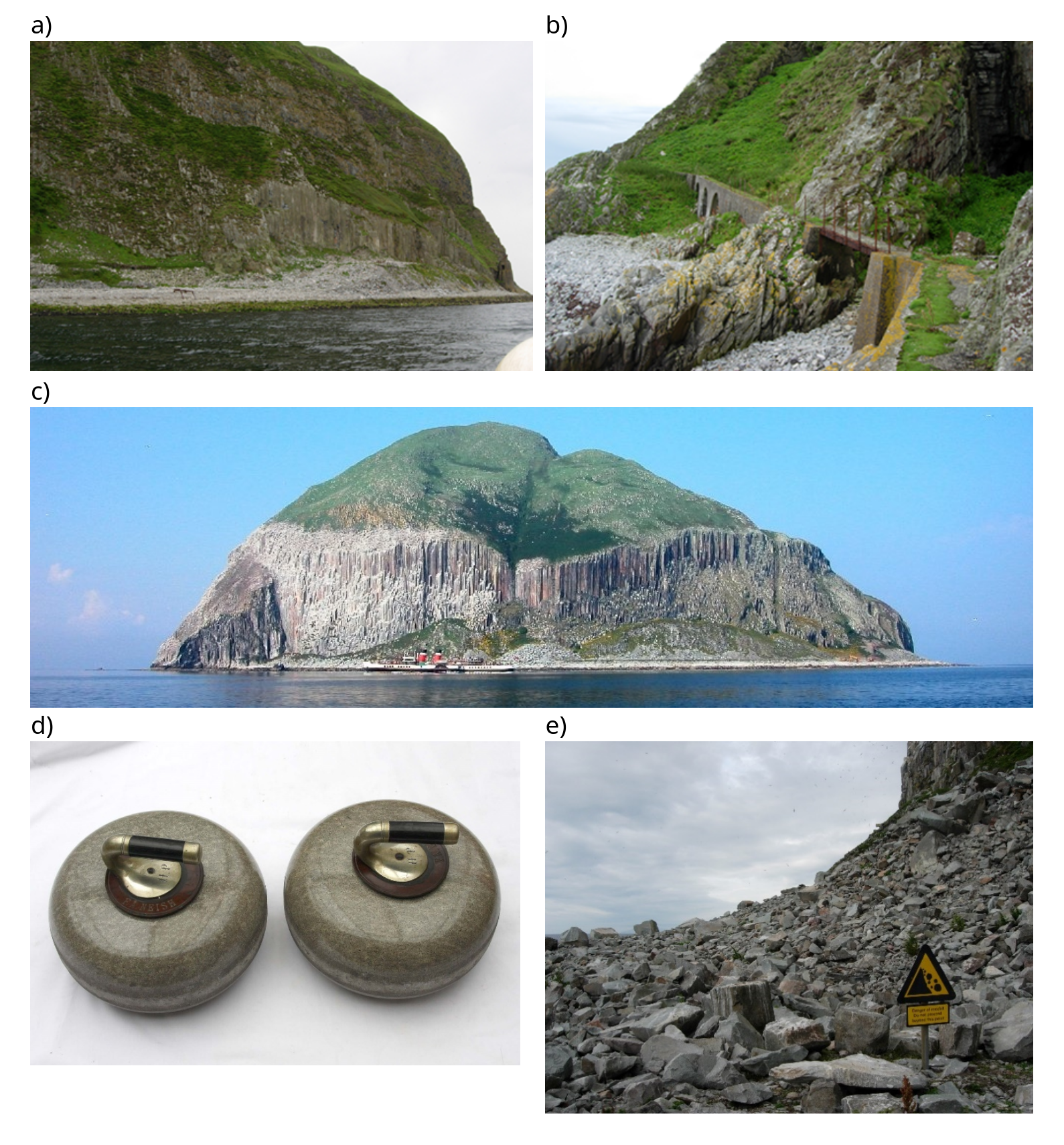
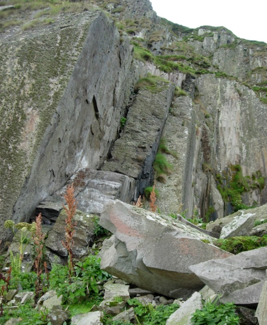
The distinctive microgranite from Ailsa Craig has traditionally been favoured as a source for the manufacture of curling stones (Kerr, 1890; Smith 1981; McDowell 2014). Blasting and quarrying ceased after 1970, but loose quarry blocks are still removed periodically for curling stone manufacture. Quarries in cliffs on the north-eastern side of the island (
2.2 Description
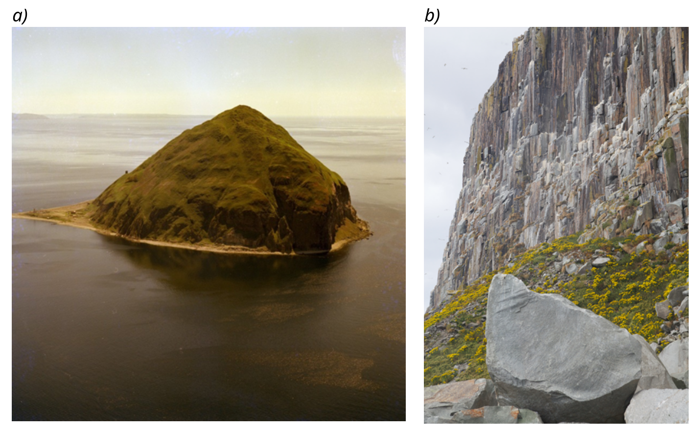
Ailsa Craig is a small rounded island c. 1.2 km in diameter, which from a distance appears to rise dramatically from the sea. However, closer inspection reveals that the cliffs are everywhere fronted by a narrow beach. The British Geological Survey (published at 1:50000 scale in 1981 without revision from the 1863–1865 survey) map of superficial deposits indicates that the modern beach is narrowest on the west and north-east sides and broadest on the south-east coast. A triangular shaped area of late- to post-glacial raised beach deposits occurs between North Point and the Trammins with a marked back feature at approximately 12 m above OD. The latter probably defines the c. 7500 BP Flandrian-age Main Postglacial palaeo-shoreline
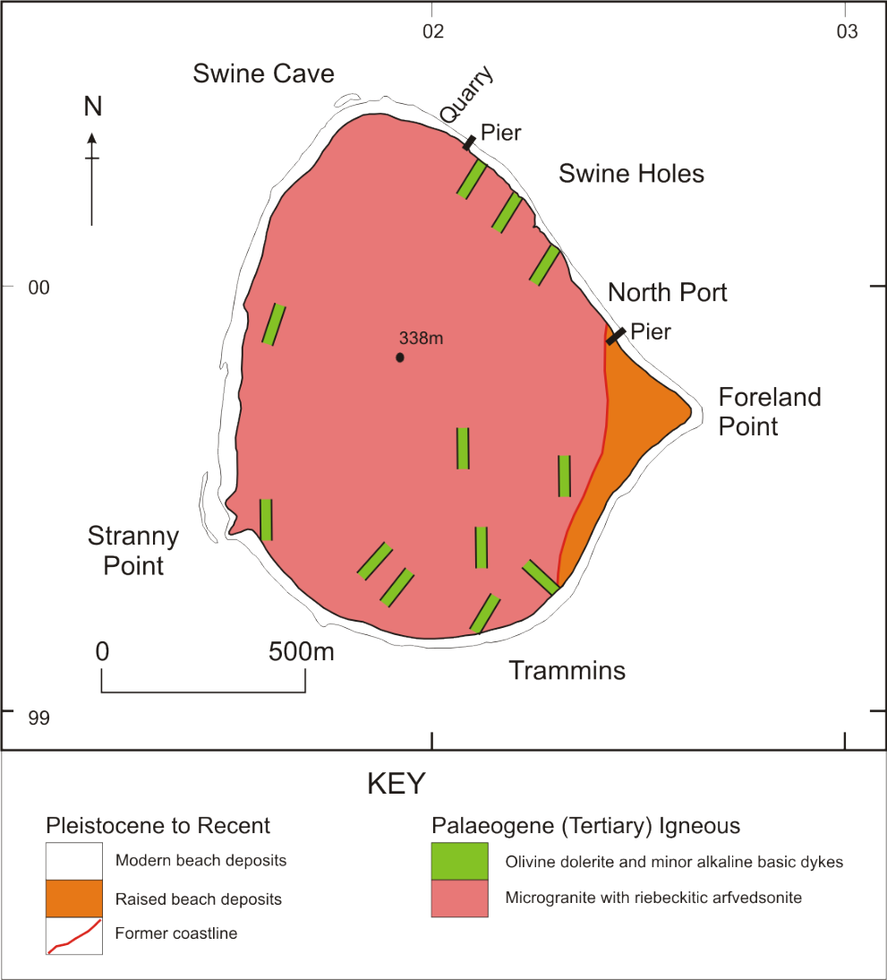
Ailsa Craig is composed almost entirely of microgranite, with the only other significant constituent being a small swarm of basic dykes that cut the microgranite
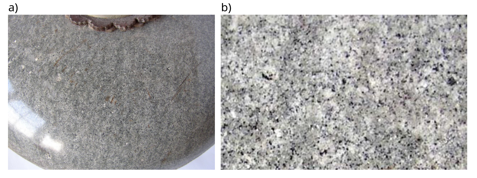
Within the overall outcrop of the intrusion, Harrison et al. (1987) recognised two previously unrecorded microgranite facies, although the distribution and boundaries between them have not been mapped out. The main component, found predominantly in the south, west and north-west sectors, is a light grey to yellowish or greenish grey, microphyric microgranite. This lithology is distinguished by a black spotted appearance resulting from randomly distributed black clots of ferromagnesian minerals within or adjacent to drusy cavities
The drusy cavities, between 1 and 10 mm across, are mostly spheroidal to ellipsoidal in shape, but may be elongate, up to 30 mm, where the rock is ‘foliated’. For the most part they are infilled with clear unstrained quartz comparable with that of the interstitial quartz/feldspar groundmass. Minor mineral constituents include magnetite, glauconite-celadonite (Harding, 1983), zircon, monazite, rutile, apatite, brookite and pyrite.
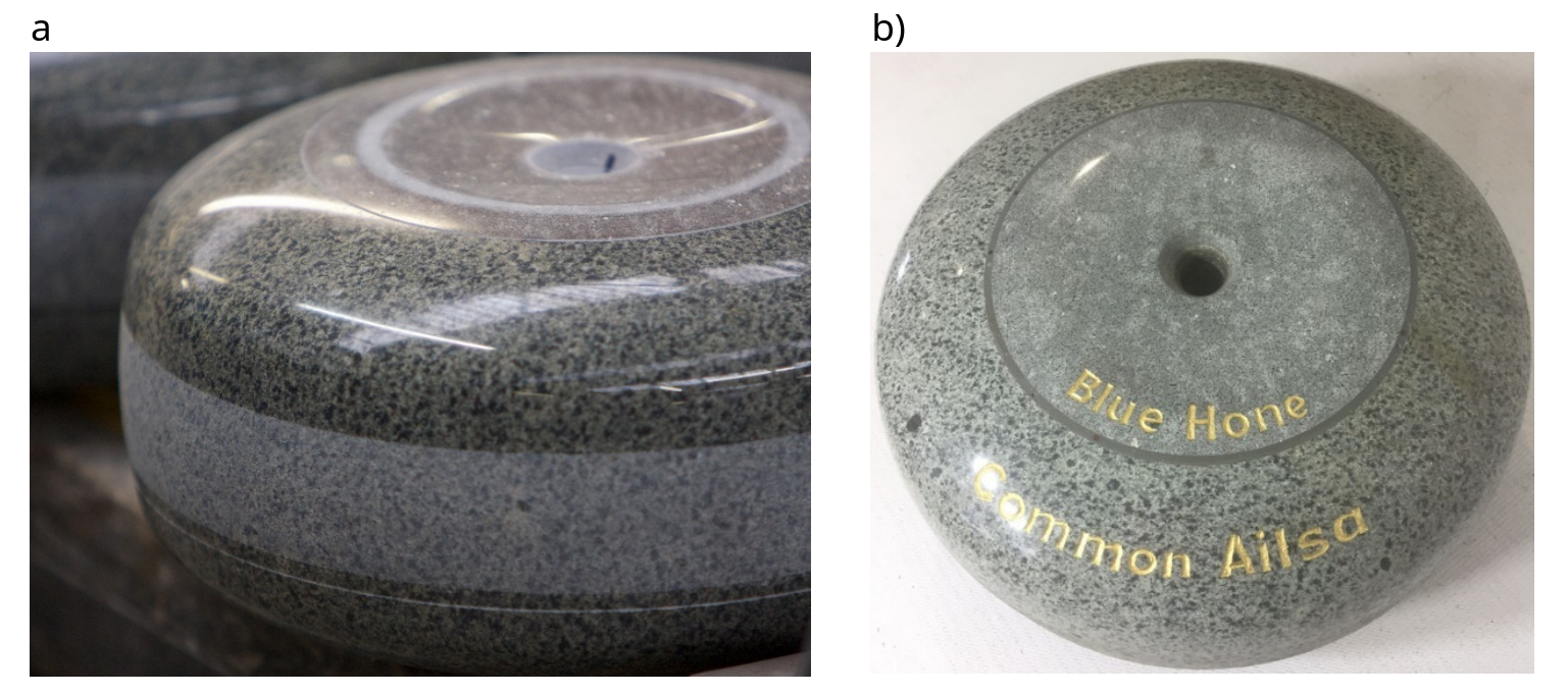
The second microgranite facies within the Ailsa Craig intrusion is a fine-grained leucocratic, microcrystalline to saccharoidal microgranite. This rock unit outcrops in both the north-eastern cliffs and the upper slopes of the island and is known as Ailsa Craig Blue Hone when used for curling stones
Ailsa Craig Red Hone (or Red Ailsa) curling stone material, which was apparently sourced from upper levels of the north-east quarry, appears to have been worked out early and is no longer in evidence at the site. An early discourse on the geology of curling stones (Heddle, 1890), however, suggests that the source of Ailsa Craig Red Hone is likely to have been an altered area of the leucocratic microgranite (Alisa Craig Blue Hone), in which feldspar was retrogressed to kaolinite, and the red colour was the result of iron oxide staining.
Small xenolithic fragments of metasedimentary rocks up to 100 mm across occur sporadically throughout the intrusion. They are most notable, however, in the north eastern part of the island, which is that part of the intrusion thought to be closest to the contact with the country rocks. The xenoliths comprise mostly pelitic siltstones, with some quartzose siltstones. Evidence of hornfelsing, metasomatism, and partial assimilation is common. The pelites consist mainly of detrital quartz grains, albite feldspar (largely altered to clay minerals), yellow mica that is associated with blue-green amphibole. The latter is optically similar to amphibole in the microgranite, but differs slightly in chemical composition. These xenolithic fragments are commonly enclosed by dark rims of arfvedsonite that accentuate the form of the included material.
Three distinct sets of sub-vertical joints in the microgranites are recognised; they are aligned NW–SE, NNW–SSE and NE–SW, although in the north-west part of the island the first set is only weakly developed. The joint sets give rise to a very distinctive columnar pattern, which led Lawson (1895) to describe these rocks as basalt and from which subsequent authors drew unjustifiable comparisons with the Giant’s Causeway. However, the columns on Ailsa Craig are not polygonal, rather their interfacial angles range from 80O to 130O. The resultant columns are either quadrilateral or pentagonal in form, and vary mainly between 0.5 and 1 m across, or occasionally up to 2 m. These dimensions facilitate the cutting and shaping of curling stones, hence the main quarries are located on the north-east cliffs where the three joint sets are best developed. Obtaining stones of suitable depth is again helped by a later set of gently dipping (predominantly seaward) joints.
The microgranite intrusion is cut by a suite of basic dykes
2.3 Interpretation
In south-west Scotland the boundary between the Midland Valley and the Southern Uplands is defined by a NE–SW trending zone of faulting, which includes the Stinchar Valley and Glen App faults. The projection of these structures off-shore passes around 25 km south of Ailsa Craig suggesting that the island lies in the Midland Valley terrane. Such faults were integral to pre- and early Paleogene tectonic events that thinned and stretched the lithosphere and controlled the siting of the various complexes within the British Paleogene Volcanic Province (BPVP), focusing the upward migration of mantle derived magma. Offshore borehole evidence (British Geological Survey, 1985) indicates that the Ailsa Craig microgranite boss was intruded through the purple and white sandstones of Permian to Triassic age.
These factors, combined with the peralkaline nature of the microgranites suggests that the Ailsa Craig intrusion belongs to the Paleogene igneous event of thermal uplift and igneous activity that pre-dated the opening of the Atlantic Ocean. This is confirmed by a single radiometric age date of 61.±.5 Ma (Bell and Williams, 2002), which is slightly older than the c. 59 Ma age derived for the Arran Northern granite centre (Dickin et al., 1981; Musset et al., 1987).
The shape and size of the island is thought to roughly reflect the original form of the intrusion. There is no evidence of any associated volcanic rocks surrounding the island and hence it is likely that Ailsa Craig is a sub-volcanic intrusion.
The two Ailsa Craig microgranite facies are both chemically and mineralogically homogeneous. Trace element geochemistry from both facies (Meighan, 1979; Harrison et al., 1987) reveals both enrichment in L-REE relative to H-REE, and a pronounced negative Eu anomaly. This might indicate that the microgranites were derived and crystallised out from a single peralkaline magmatic source. This led Meighan (1979) to suggest that such a magma was unlikely to have been generated by crustal anatexis, which is borne out by the initial 87Sr/86Sr ratio of 0.702±.009 derived by Harrison et al. (1987). On balance, both authors suggest that the origin of the intrusion more readily fits a model of fractional crystallisation of feldspar (the negative Eu anomaly) from a primitive mantle-derived tholeiitic basic magma within an upper crustal magma chamber.
The later suite of basic dykes cutting the microgranite is thought to represent pulsed injections of basaltic magma chemically and mineralogically different to that from which the microgranite magma was derived. These dykes are probably analogous to the widespread swarm of such dykes that were emplaced towards the end of the Paleogene igneous event. It is possible that they are contemporaneous with those of the Paleogene centre on Arran which lies 25–30 km to the north, particularly as the two intrusive centres are linked by a magnetic anomaly, which contrasts markedly with the low magnetic signature of the sedimentary rocks that largely underlie this part of the Clyde estuary (British Geological Survey, 1998).
Alkali ferromagnesian minerals occur in other intrusions within the British Paleogene Volcanic Province, for example the sanidine-microporphyritic trachyte sill on Holy Island to the east of Arran is riebeckite-bearing (Emeleus and Bell, 2005). Aenigmatite is recorded in the dolerite Main Sill intrusion on the Shiant Isles, which forms part of the Little Minch Sill Complex (Gibson and Jones, 1991; Henderson et al., 2000) and in the Cnoc Rhonastil dolerite intrusion on Islay. The peralkaline granite of Rockall on the western edge of the British Palaeogene Volcanic Province is a possible analogue (Harrison, 1975), although this intrusion is part of an intrusive complex with the nearby Helens Reef micro-gabbro (Emeleus and Bell, 2005). The Rockall granite is, however, unusually rich in aegerine and riebeckite (13 to 27 per cent), with ferromagnesian minerals forming up to 68 per cent in a variant dubbed ‘rockallite’ that forms vein-like segregations within the granite.
2.4 Conclusions
The Ailsa Craig GCR site is of national importance and is relatively unique within intrusive magmatic history of the British Paleogene Volcanic Province (BPVP). The small peralkaline microgranite intrusion that forms the island of Ailsa Craig within the Firth of Clyde area represents the southern-most intrusion of the BPVP within Scotland. The origin of these granitic rocks appears to be the result of fractionation from a mantle-derived basic magma with no crustal contamination, and hence there is no close analogue of the Ailsa Craig intrusion elsewhere within the BPVP. The intrusion is also unusual, not only in a UK context but worldwide in containing the comparatively rare alkaline ferromagnesian minerals riebeckitic arfvedsonite, hedenbergite-acmite and aenigmatite, making the site mineralogically distinctive. The close association of the ferromagnesian minerals with drusy cavities suggests that, unlike the more common dark minerals, they formed late in the cooling and crystallisation history of the magma. The tendency for the ferromagnesian minerals to occur as clots gives the rock a very distinctive ‘spotty’ appearance, which has been invaluable as a tracer in establishing glacial erosion and transport of material during Pleistocene glaciation. Working of the microgranite for both building and curling stone industries presents a cultural heritage that is of world-wide acclaim.
Acknowedgements
First of all a huge thank you to Bob Cowan for being an indefatigable and enthusiastic source of knowledge on curling stone history, for pointing us towards suitable curling stone references including Heddle’s fascinating 19th century account of the science of curling, for permission to use his photos in this report, and for sourcing us additional photos from his contacts. Thank you to those whose photos we’ve used: to Maybole Community Council for permissions to use David Law’s photo from their website, to the British Geological Survey, to Colin MacFadyen, Bob Cowan, Richard Gray and Dr Graeme Adam. Thanks also to Andrew Highton for drafting the geological map for Figure 3. Finally many thanks to the UK agency staff who have variously helped develop the format for this report and provided peer review: Vanessa Brazier Kirkbride (SNH), Colin MacFadyen (SNH), Raymond Roberts (NRW), Stewart Campbell (NRW), Hannah Townley (NE), Colin Prosser (NE), and Eleanor Brown (NE).
Note — Access to the countryside
GCR site descriptions are not intended for use as a field guide. The description or mention of any site should not be taken as an indication that access to a site is open. Most sites described are in private ownership, and their inclusion in a published GCR site description is solely for the purpose of justifying their conservation. Their description or appearance on a map in a published GCR site description should not be construed as an invitation to visit. Prior consent for visits should always be obtained from the landowner and/or occupier.
Information on conservation matters relating to Sites of Special Scientific Interest (SSSIs) or National Nature Reserves (NNRs) in Scotland, including advice on contacting site owners, may be obtained from Scottish Natural Heritage:
Scottish Natural Heritage, Great Glen House, Leachkin Road, Inverness IV3 8NW, or check our web site https://www.nature.scot/
References
Bell, B.R., Williams, I.T., 2002. Tertiary igneous activity. In: Trewin, N.H. (Ed.). Geology of Scotland 4th edition. Geological Society of London.
British Geological Survey, 1981. Girvan. Scotland Sheet 7. Drift Geology. 1:50,000 (Keyworth, Nottingham: British Geological Survey).
British Geological Survey, 1988. Girvan. Scotland Sheet 7. Solid Geology. 1:50,000 (Keyworth, Nottingham: British Geological Survey).
British Geological Survey, 1985. Clyde Sheet 55ON-06OW Solid geology map: 1:250,000 (Keyworth, Nottingham: British Geological Survey).
British Geological Survey, 1998. Colour Shaded Relief Magnetic Anomaly Map of Britain, Ireland and adjacent areas. Royles, C.P. and Smith, I.F. (compilers) 1:1 500 000 scale (Keyworth, Nottingham, United Kingdom: British Geological Survey).
Brown, E.J., Evans, D.H., Larwood, J.G., Prosser, C.D., Townley, H.C., 2018. Geoconservation and geoscience in England: a mutually beneficial relationship. Proceedings of the Geologists’ Association 129, 492–504.
Burek, C. V., Prosser, C. D., 2008. The history of geoconservation: an introduction. In Burek, C. V., Prosser, C. D. (Eds), The history of geoconservation, Geological Society, London, Special Publications 300, 1–5.
Chambers, L.M., Pringle, M.S., 2001. Age and duration of activity at the Mull Tertiary igneous centre, Scotland, and conformation of the existence of subchrons during anomally 26r. Earth and Planetary Science Letters 193, 333–345.
Dickin, A.P., Moorbath, S., Welke, H.J., 1981. Isotope, trace element and major element geochemistry of Tertiary igneous rocks, Isle of Arran, Scotland. Transactions of the Royal Society of Edinburgh: Earth Sciences 72,159–170.
Ellis, N.V. (Ed.), Bowen. D.Q., Campbell, S., Knill, J.L., McKirdy, A.P., Prosser, C.D., Vincent, M.A., Wilson, R.C.L., 1996. An Introduction to the geological Conservation Review. GCR Series No. 1, Joint nature Conservation Committee, Peterborough.
Ellis, N., 2011. The Geological Conservation Review (GCR) in Great Britain – rationale and methods. Proceedings of the Geologists’ Association 122, 353–362
Emeleus, C.H., Bell, B.R., 2005. The Palaeogene volcanic districts of Scotland. 4th edition. Nottingham, UK, British Geological Survey (British Regional Geology 3), 214pp.
Emeleus, C.H., Gyopari M.C., 1992. British Tertiary Volcanic Province, Geological Conservation Review Series No. 4, Joint Nature Conservation Committee, Peterborough, 259 pp.
Evans, A.L., Fitch F.J., Miller J.A., 1973. Potassium-argon age determinations on some British Tertiary igneous rocks. Journal of the Geological Society of London 129, 419–43.
Geological Survey of Scotland, 1869. Explanation of sheet 7: Ayrshire: South-Western District. Memoir of the Geological Survey of Great Britain.
Gibson, S.A., Jones, A.P., 1991. Igneous stratigraphy and internal structure of the Little Minch Sill Complex, Trotternish Peninsula, northern Skye, Scotland. Geological Magazine 128, 51–66.
Harding, R.R., 1983. Zr-rich pyroxenes and glauconitic minerals in the Tertiary alkali granite of Ailsa Craig. Scottish Journal of Geology 19, 219–227.
Harrison, R.K., 1975. Expeditions to Rockall. 1971–1972. Report of the Institute of Geological Sciences No. 75/1.
Harrison, R.K., Stone, P., Cameron, I. B., Elliot, R. W., Harding, R. R., 1987. Geology, petrology and geochemistry of Ailsa Craig, Ayrshire. Report of the British Geological Survey 16, No 9.
Heddle, M.F., 1890. The Science of Curling. In: Kerr, J., The History of Curling, and Fifty Years of the Royal Caledonian Curling Club. David Douglas, Edinburgh. Online at: https://electricscotland.com/history/curling/index.htm [accessed June 2020].
Heffer K.J., 2005. The NERC Micro to Macro Programme: implications for fluid resource management. In: Shaw, R.P. (Ed.), Understanding the Micro to Macro behaviour of rock-fluid systems, Geological Society, London, Special Publications 249, 5–27.
Henderson, C.M.B., Gibb, F.G.F., Foland, K.A., 2000. Mineral fractionation and pre- and post-emplacement processes in the uppermost part of the Shiant Isles Main Sill. Mineralogical Magazine 64, 779–790.
Howie, R.A., Walsh, J.N., 1981. Riebeckitic arfedsonite and aenigmatite from the Ailsa Craig microgranite. Scottish Journal of Geology 17, 123–128.
Hughes, H.S.R., McDonald, I., Kerr, A.C., 2015. Platinum-group element signatures in the North Atlantic Igneous Province: Implications for mantle controls on metal budgets during continental breakup. Lithos 233, 89–110.
Kerr, J., 1890. The History of Curling, and Fifty Years of the Royal Caledonian Curling Club. David Douglas, Edinburgh. Online at: https://electricscotland.com/history/curling/index.htm [accessed June 2020].
Lawson, R., 1895. Ailsa Craig, its history and natural history. In: Parlane, J., Parlane, R., Paisley, 90 pp..
MaCartney, W.N., 1869. The geology of Ailsa Craig. Proceedings of the Natural History Society of Glasgow 1, 151–157.
McDowell, ML 2014, 'That little sugarloaf Island': Ailsa Craig, romance, reality and the branding of Scottish sport and leisure, 1707-2013. Sport in History 34, 249-275. Online at: https://www.research.ed.ac.uk/portal/en/publications/that-little-sugarloaf-island(c70104e5-7569-4e9f-851c-7b0afc7b0eb7).html [accessed June 2020]
Mark, N., Schofield, N., Gardiner, D., Holt, L., Grove, C., Watson, D., Alexander, A., Poore, H., 2018. Overthickening of sedimentary sequences by igneous intrusions. Journal of the Geological Society, London 176, 46–60.
Meighan, I., 1979. The acid igneous rocks of the British Tertiary Province. Bulletin of the Geological Survey of Great Britain No. 70, 10–22.
Mussett, A.E., Dagley, P., Hodgson, B., Skelhorn, R.R., 1987. Palaeomagnetism and the age of the quartz porphyry intrusion, Isle of Arran. Scottish Journal of Geology 23, 9–22.
Nicoli, G., Matthews, S., 2019. The Hebridean Igneous Province plumbing system: A phase equilibria perspective. Lithos 348–349, doi.org/10.1016/j.lithos.2019.105194.
Potts P.J., Holbrook J.R., 1987. Ailsa Craig – the history of a reference material. Geostandards Newsletter 11, 257–60.
Prosser, C. D., 2013a. Our rich and varied geoconservation portfolio: the foundation for the future. Proceedings of the Geologists’ Association 124, 568–580.
Prosser, C. D., 2013b. Planning for geoconservation in the 1940s: an exploration of the aspirations that shaped the first national geoconservation legislation. Proceedings of the Geologists’ Association 124, 337–342.
Smith, D.B., 1981. Curling: an illustrated history. John Donald, Edinburgh. ISBN 10: 085976074X ISBN 13: 9780859760744.
Teall, J.J.H., 1891. On a microgranite containing riebeckite from Ailsa Craig. Mineralogical Magazine 9, 219–222.
Upton, B.G.J., 1988. History of Tertiary igneous activity in the N Atlantic borderlands. In: Morton, A.C., Parson, L.M. (Eds), Early Tertiary volcanism and the opening of the NE Atlantic. Geological Society of London Special Publications 39, 429–454.
Williamson, I.T., Bell, B.R., 2012. The
Wimbledon, W.A., Benton, M.J., Bevins, R.E., Black, G.P., Bridgland, D.R., Cleal, C.J., Cooper, R.G., May, V.J., 1995. The development of a methodology for the selection of British geological sites for conservation: Part 1. Modern Geology 20, 159–202.