4 Site assessments
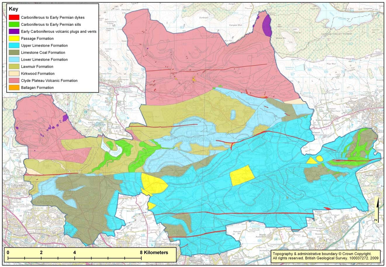
(Map 1) Geological map of East Dunbartonshire.
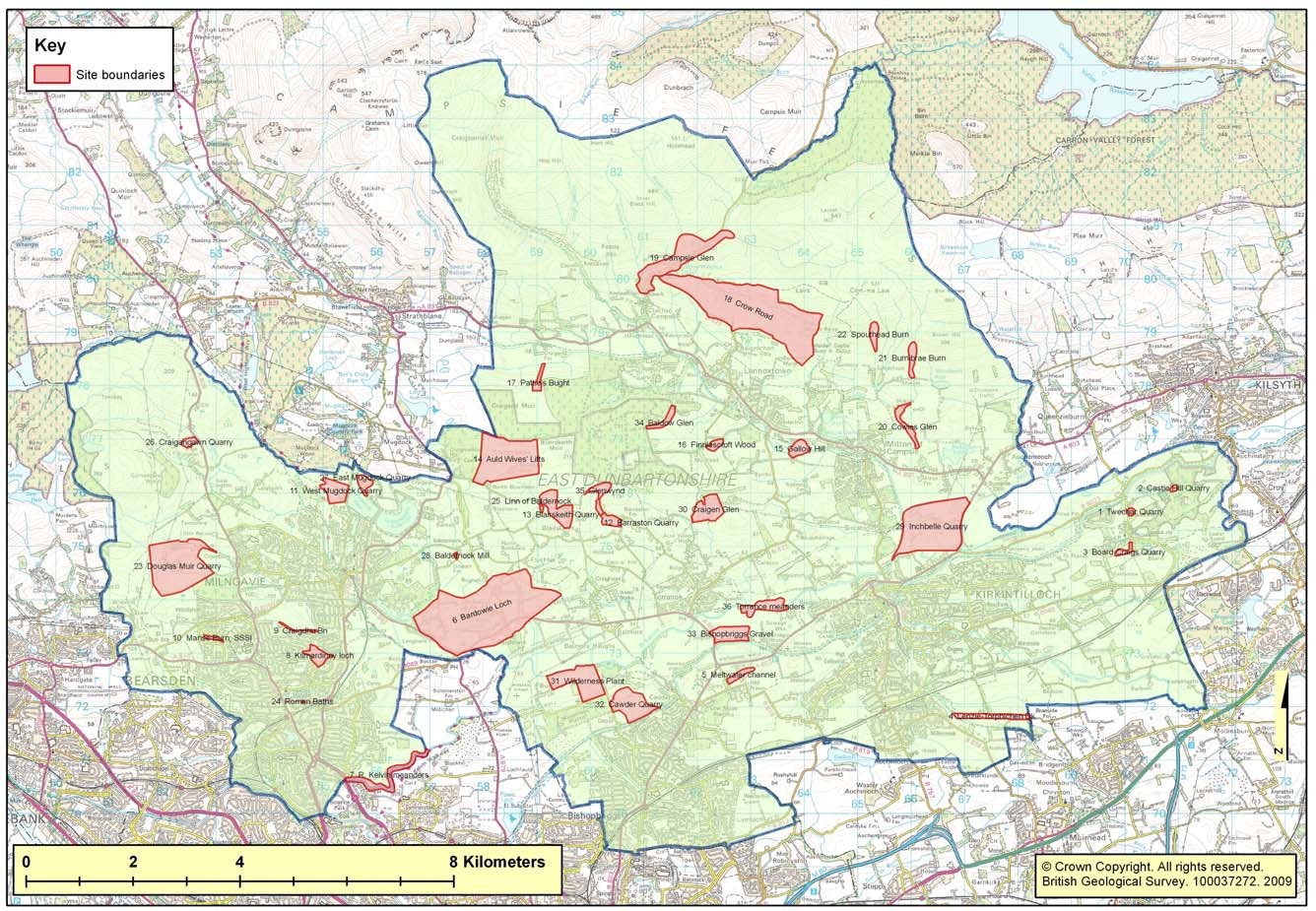
(Map 2) Location of sites visited.
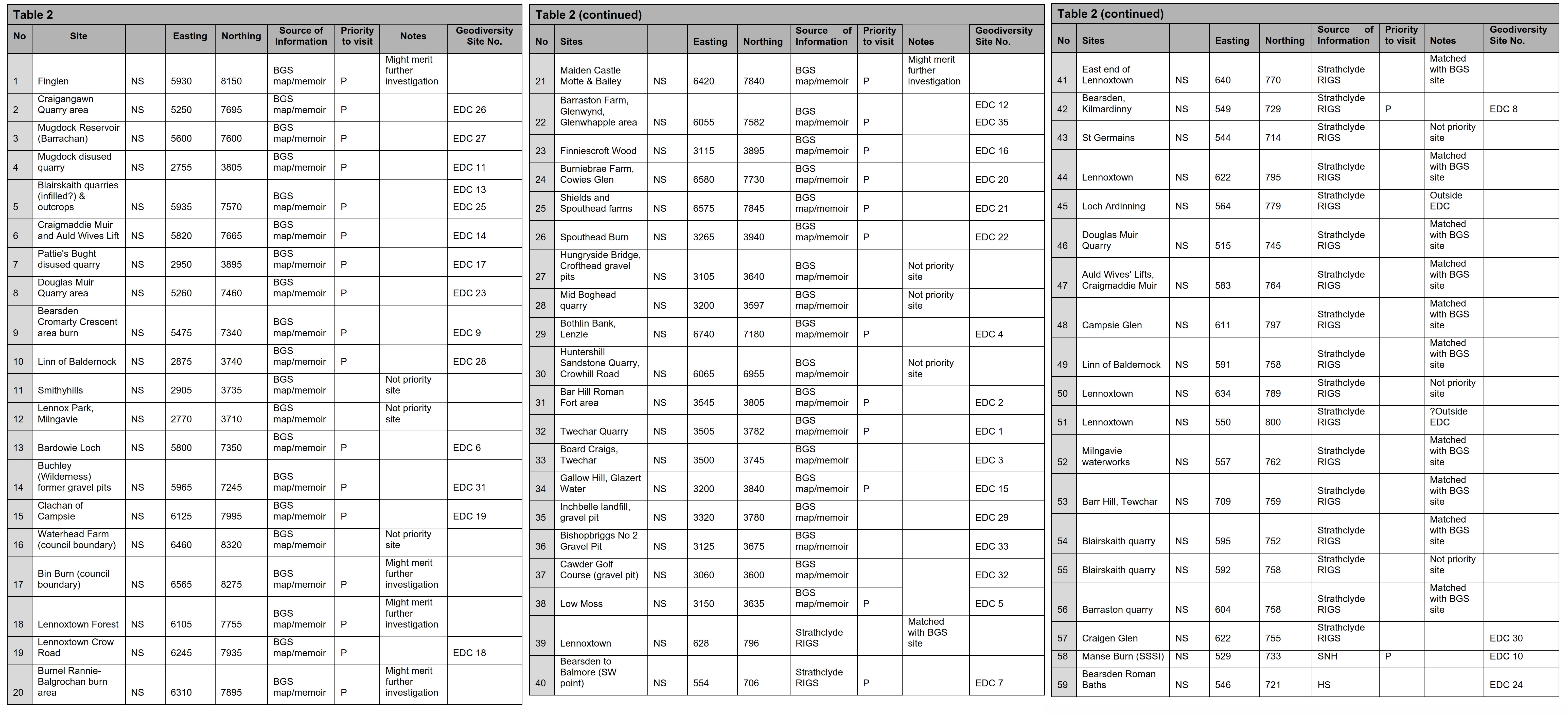
(Table 2) Initial list of potential geodiversity sites compiled from a variety of sources (see 3.1).
| No |
Site |
100 km square |
Easting |
Northing |
Grid Reference |
Source of Information |
Priority to visit |
Notes |
Geodiversity Site No. |
| 1 |
Finglen |
NS |
5930 |
8150 |
[NS 5930 8150] |
BGS map/memoir |
P |
Might merit further
investigation |
|
| 2 |
Craigangawn Quarry area |
NS |
5250 |
7695 |
[NS 5250 7695] |
BGS map/memoir |
P |
|
EDC 26 |
| 3 |
Mugdock Reservoir (Barrachan) |
NS |
5600 |
7600 |
[NS 5600 7600] |
BGS map/memoir |
P |
|
EDC 27 |
| 4 |
Mugdock disused quarry |
NS |
2755 |
3805 |
[NS 2755 3805] |
BGS map/memoir |
P |
|
EDC 11 |
| 5 |
Blairskaith quarries (infilled?) & outcrops |
NS |
5935 |
7570 |
[NS 5935 7570] |
BGS map/memoir |
P |
|
EDC 13 EDC 25 |
| 6 |
Craigmaddie Muir and Auld Wives Lift |
NS |
5820 |
7665 |
[NS 5820 7665] |
BGS map/memoir |
P |
|
EDC 14 |
| 7 |
Pattie's Bught disused quarry |
NS |
2950 |
3895 |
[NS 2950 3895] |
BGS map/memoir |
P |
|
EDC 17 |
| 8 |
Douglas Muir Quarry area |
NS |
5260 |
7460 |
[NS 5260 7460] |
BGS map/memoir |
P |
|
EDC 23 |
| 9 |
Bearsden
Cromarty Crescent area burn |
NS |
5475 |
7340 |
[NS 5475 7340] |
BGS map/memoir |
P |
|
EDC 9 |
| 10 |
Linn of Baldernock |
NS |
2875 |
3740 |
[NS 2875 3740] |
BGS map/memoir |
P |
|
EDC 28 |
| 11 |
Smithyhills |
NS |
2905 |
3735 |
[NS 2905 3735] |
BGS map/memoir |
|
Not priority site |
|
| 12 |
Lennox Park, Milngavie |
NS |
2770 |
3710 |
[NS 2770 3710] |
BGS map/memoir |
|
Not priority site |
|
| 13 |
Bardowie Loch |
NS |
5800 |
7350 |
[NS 5800 7350] |
BGS map/memoir |
P |
|
EDC 6 |
| 14 |
Buchley (Wilderness) former gravel pits |
NS |
5965 |
7245 |
[NS 5965 7245] |
BGS map/memoir |
P |
|
EDC 31 |
| 15 |
Clachan of Campsie |
NS |
6125 |
7995 |
[NS 6125 7995] |
BGS map/memoir |
P |
|
EDC 19 |
| 16 |
Waterhead Farm (council boundary) |
NS |
6460 |
8320 |
[NS 6460 8320] |
BGS map/memoir |
|
Not priority site |
|
| 17 |
Bin Burn (council boundary) |
NS |
6565 |
8275 |
[NS 6565 8275] |
BGS map/memoir |
P |
Might merit further
investigation |
|
| 18 |
Lennoxtown Forest |
NS |
6105 |
7755 |
[NS 6105 7755] |
BGS map/memoir |
P |
Might merit further investigation |
|
| 19 |
Lennoxtown Crow Road |
NS |
6245 |
7935 |
[NS 6245 7935] |
BGS map/memoir |
P |
|
EDC 18 |
| 20 |
Burnel Rannie- Balgrochan burn area |
NS |
6310 |
7895 |
[NS 6310 7895] |
BGS map/memoir |
P |
Might merit further investigation |
|
| 21 |
Maiden Castle Motte & Bailey |
NS |
6420 |
7840 |
[NS 6420 7840] |
BGS map/memoir |
P |
Might merit further investigation |
|
| 22 |
Barraston Farm, Glenwynd, Glenwhapple area |
NS |
6055 |
7582 |
[NS 6055 7582] |
BGS map/memoir |
P |
|
EDC 12 EDC 35 |
| 23 |
Finniescroft Wood |
NS |
3115 |
3895 |
[NS 3115 3895] |
BGS map/memoir |
P |
|
EDC 16 |
| 24 |
Burniebrae Farm, Cowies Glen |
NS |
6580 |
7730 |
[NS 6580 7730] |
BGS map/memoir |
P |
|
EDC 20 |
| 25 |
Shields and Spouthead farms |
NS |
6575 |
7845 |
[NS 6575 7845] |
BGS map/memoir |
P |
|
EDC 21 |
| 26 |
Spouthead Burn |
NS |
3265 |
3940 |
[NS 3265 3940] |
BGS map/memoir |
P |
|
EDC 22 |
| 27 |
Hungryside Bridge, Crofthead gravel pits |
NS |
3105 |
3640 |
[NS 3105 3640] |
BGS map/memoir |
|
Not priority site |
|
| 28 |
Mid Boghead quarry |
NS |
3200 |
3597 |
[NS 3200 3597] |
BGS map/memoir |
|
Not priority site |
|
| 29 |
Bothlin Bank, Lenzie |
NS |
6740 |
7180 |
[NS 6740 7180] |
BGS map/memoir |
P |
|
EDC 4 |
| 30 |
Huntershill Sandstone Quarry, Crowhill Road |
NS |
6065 |
6955 |
[NS 6065 6955] |
BGS map/memoir |
|
Not priority site |
|
| 31 |
Bar Hill Roman Fort area |
NS |
3545 |
3805 |
[NS 3545 3805] |
BGS map/memoir |
P |
|
EDC 2 |
| 32 |
Twechar Quarry |
NS |
3505 |
3782 |
[NS 3505 3782] |
BGS map/memoir |
P |
|
EDC 1 |
| 33 |
Board Craigs, Twechar |
NS |
3500 |
3745 |
[NS 3500 3745] |
BGS map/memoir |
|
|
EDC 3 |
| 34 |
Gallow Hill, Glazert Water |
NS |
3200 |
3840 |
[NS 3200 3840] |
BGS map/memoir |
P |
|
EDC 15 |
| 35 |
Inchbelle landfill, gravel pit |
NS |
3320 |
3780 |
[NS 3320 3780] |
BGS map/memoir |
|
|
EDC 29 |
| 36 |
Bishopbriggs No 2 Gravel Pit |
NS |
3125 |
3675 |
[NS 3125 3675] |
BGS map/memoir |
|
|
EDC 33 |
| 37 |
Cawder Golf Course (gravel pit) |
NS |
3060 |
3600 |
[NS 3060 3600] |
BGS map/memoir |
|
|
EDC 32 |
| 38 |
Low Moss |
NS |
3150 |
3635 |
[NS 3150 3635] |
BGS map/memoir |
P |
|
EDC 5 |
| 39 |
Lennoxtown |
NS |
628 |
796 |
[NS 628 796] |
Strathclyde RIGS |
|
Matched with BGS site |
|
| 40 |
Bearsden to Balmore (SW point) |
NS |
554 |
706 |
[NS 554 706] |
Strathclyde RIGS |
P |
|
EDC 7 |
|
East end of Lennoxtown |
NS |
640 |
770 |
[NS 640 770] |
Strathclyde RIGS |
|
Matched with BGS site |
|
| 42 |
Bearsden, Kilmardinny |
NS |
549 |
729 |
[NS 549 729] |
Strathclyde RIGS |
P |
|
EDC 8 |
| 43 |
St Germains |
NS |
544 |
714 |
[NS 544 714] |
Strathclyde RIGS |
|
Not priority site |
|
| 44 |
Lennoxtown |
NS |
622 |
795 |
[NS 622 795] |
Strathclyde RIGS |
|
Matched with BGS site |
|
| 45 |
Loch Ardinning |
NS |
564 |
779 |
[NS 564 779] |
Strathclyde RIGS |
|
Outside EDC |
|
| 46 |
Douglas Muir Quarry |
NS |
515 |
745 |
[NS 515 745] |
Strathclyde RIGS |
|
Matched with BGS site |
|
| 47 |
Auld Wives' Lifts, Craigmaddie Muir |
NS |
583 |
764 |
[NS 583 764] |
Strathclyde RIGS |
|
Matched with BGS site |
|
| 48 |
Campsie Glen |
NS |
611 |
797 |
[NS 611 797] |
Strathclyde RIGS |
|
Matched with BGS site |
|
| 49 |
Linn of Baldernock |
NS |
591 |
758 |
[NS 591 758] |
Strathclyde RIGS |
|
Matched with BGS site |
|
| 50 |
Lennoxtown |
NS |
634 |
789 |
[NS 634 789] |
Strathclyde RIGS |
|
Not priority site |
|
| 51 |
Lennoxtown |
NS |
550 |
800 |
[NS 550 800] |
Strathclyde RIGS |
|
?Outside EDC |
|
| 52 |
Milngavie waterworks |
NS |
557 |
762 |
[NS 557 762] |
Strathclyde RIGS |
|
Matched with BGS site |
|
| 53 |
Barr Hill, Tewchar |
NS |
709 |
759 |
[NS 709 759] |
Strathclyde RIGS |
|
Matched with BGS site |
|
| 54 |
Blairskaith quarry |
NS |
595 |
752 |
[NS 595 752] |
Strathclyde RIGS |
|
Matched with BGS site |
|
| 55 |
Blairskaith quarry |
NS |
592 |
758 |
[NS 592 758] |
Strathclyde RIGS |
|
Not priority site |
|
| 56 |
Barraston quarry |
NS |
604 |
758 |
[NS 604 758] |
Strathclyde RIGS |
|
Matched with BGS site |
|
| 57 |
Craigen Glen |
NS |
622 |
755 |
[NS 622 755] |
Strathclyde RIGS |
|
|
EDC 30 |
| 58 |
Manse Burn (SSSI) |
NS |
529 |
733 |
[NS 529 733] |
SNH |
P |
|
EDC 10 |
| 59 |
Bearsden Roman Baths |
NS |
546 |
721 |
[NS 546 721] |
HS |
|
|
EDC 24 |
Bibliography