EDC 21: Burniebrae Burn, Shields Farm
Grid reference: [NS 66024 78690]
Site type: Natural section
Site ownership: Not known
Current use: Open country
Field surveyor: Sarah Arkley & Luis Albornoz-Parra
Current geological designations: None
Date visited: 13th March 2009
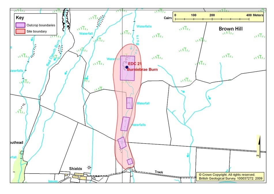
Site map
(Figure 21) Burniebrae Burn Location Map
Summary description
Stream sections up the Burnibrae Burn expose a variety of sedimentary and igneous rock types, features and tectonic structures.
The lower part of the site exposes Limestone CoalLimestone Coal Formation and the Lower Limestone Formation strata. The upper part of the site exposes the faulted contact of the sedimentary rocks with lavas of the Clyde Plateau Volcanic Formation which make up the high ground of the Campsie Fells.
The Top Hosie Limestone crops out in the burn at the southern end of the site and a section through the overlying dark mudstones is exposed in the bank sides.
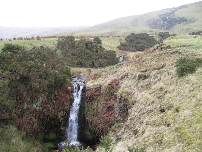
A series of waterfalls along the burn expose excellent sections through sedimentary cycles of the Limestone CoalLimestone Coal Formation, typically displaying dark-coloured mudstones at the base, passing upwards into siltstones, with a thick unit of sandstone at the top forming the lip of the waterfall. The repeated sedimentary cycles in the geological sequence has created an equal number of waterfalls as the burn flows down over the sequence.
Towards the northern end of the site, the Campsie Fault, trending ESE-WNW, cuts across the burn. The fault brings the sedimentary rocks described above into contact with the lava flows belonging to the much older Clyde Plateau Volcanic Formation. The composition and nature of these two rock types is very different and expressed by the presence of a large waterfall, the sedimentary rocks have been preferentially eroded by ice and water.
EDC 21: Stratigraphy and rock types
Age: Upper Carboniferous Formation: Limestone CoalLimestone Coal Formation
Rock type: Sedimentary Rock Cycles of the Clackmannan Group Type
Age: Lower Carboniferous Formation: Top Hosie Limestone, Lower Limestone Formation
Rock type: Limestone
Age: Lower Carboniferous Formation: Lower Limestone Formation
Rock type: Sedimentary Rock Cycles of the Clackmannan Group Type
Age: Lower Carboniferous Formation: Clyde Plateau Volcanic Formation
Rock type: Tuff and agglomerate
Age: Lower Carboniferous Formation: Clyde Plateau Volcanic Formation
Rock type: Microporphyritic basalt
Assessment of site value
Access and safety
Aspect/Description
Road access and parking Parked at Shields Farm, space for a few cars with farmers permission
Safety of access Track goes eastwards through Shields Farm and crosses Burniebrae Burn. Access is possible along the burn itself in most places, waterfalls can be by- passed by grassy slopes either side. Open hillside either side of the burn allows good access.
Safety of exposure Care should be taken near the waterfalls and if the ground is wet the grassy slopes can be quite slippery.
Permission to visit Permission granted by farmer at Shields Farm
Current condition Good
Current conflicting activities None
Restricting conditions None, bit exposed in poor weather
Nature of exposure Stream and bank side exposures
Culture, heritage & economic
Historic, archaeological & literary associations None known. Rating: 0
Aesthetic landscape Nice open country on the edge of the Campsie Fells, nice stream section with numerous good waterfalls and views southwards. Rating: 5
History of earth sciences None known. Rating: 0
Economic geology None recorded. Rating: 0
EDC 21: Geoscientific merit
EDC 21: Burniebrae Burn, Shields Farm. Geoscientific merit.
Total Geoscientific merit score 55
Current site value
Community Rating: 4.
Education Rating: 5.
Fragility and potential use of the site
Fragility None
Potential use Higher/Further Education, School, Geotrail, Multidisciplinary
Geodiversity value
The main value of this site is the high quality and number of sections exposed up the burn, through a variety of sedimentary and igneous rocks, and the well-exposed nature of the Campsie Fault. In particular, the exposures of the Limestone CoalLimestone Coal Formation are important in the East Dunbartonshire context. Rating: 8.
Photographs
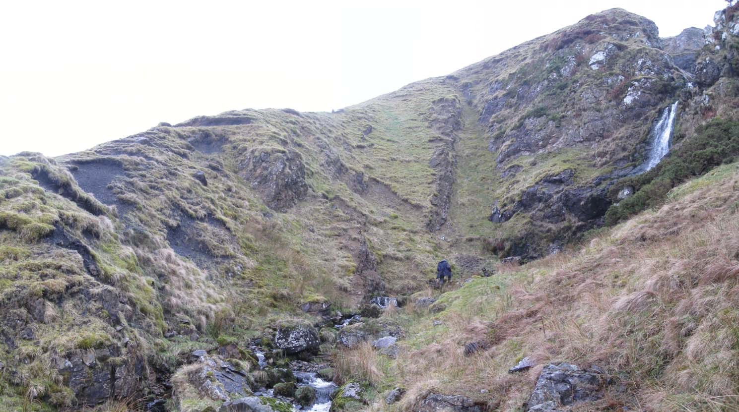
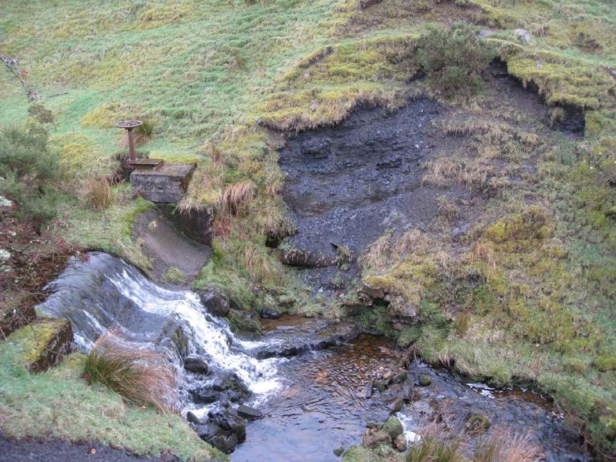
(Photo 119) View from Shields Farm looking NNE up to the waterfalls in Burniebrae Burn. The lower ground is underlain by sedimentary rocks belonging to the Lower Limestone Formation and Limestone CoalLimestone Coal Formation. The higher ground is underlain by more resistant igneous rocks belonging to the Clyde Plateau Volcanic Formation. The waterfall is located on a fault which separates the two units.
(Photo 120) A series of smaller waterfalls have formed as the burn flows across the Limestone CoalLimestone Coal Formation, highlighting variations in the underlying sedimentary rocks. The formation consists of a series of sedimentary cycles, consisting mainly of mudstones, siltstones and sandstones. The more resistant sandstone beds form the caps to the waterfalls. Looking N.
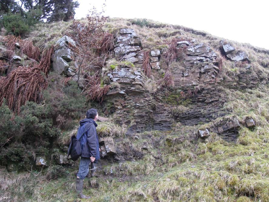
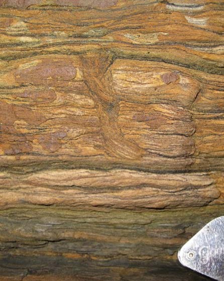
(Photo 121) A typical sedimentary cycle in the Limestone CoalLimestone Coal Formation seen in the bank of the Burniebrae Burn. The cycles, which average between 5 and 10m thick, usually consist of soft black mudstones at the base, passing upwards into siltstones and sandstones (generally the thickest unit). Looking NE.
(Photo 122) Close-up of a sub-vertical burrow, in fine-grained horizontally laminated sandstone. This illustrates where an animal has moved through the unconsolidated sediment soon after deposition, disrupting the ripple laminations.
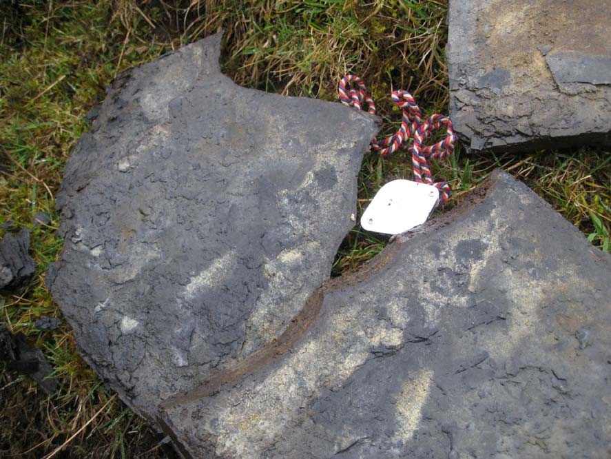
(Photo 123) A fallen block from the Limestone CoalLimestone Coal Formation, showing the impression of a tree branch, probably Lepidodendron, indicating the presence of substantial vegetation during the time of deposition.
(Photo 124) Panorama of the southern edge of the basaltic rocks making up the Clyde Plateau Volcanic Formation, represented by the waterfall. Looking NE.
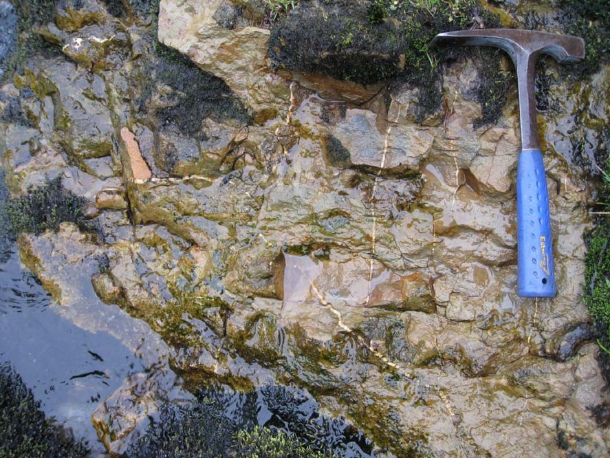
(Photo 125) Close-up of mineralised joints (thin white infilled cracks) near the fault which separates the sedimentary rocks of the Lower Limestone Formation and the igneous rocks of the Clyde Plateau Volcanic Formation.
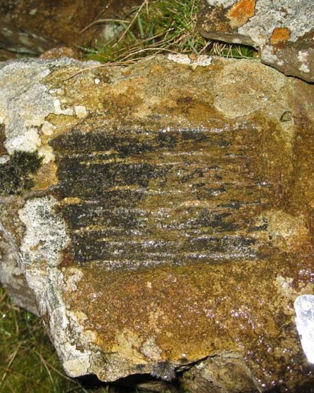
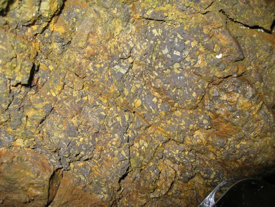
(Photo 126) Close-up of volcanic tuff, displaying fine-grained ash (purple) and crystals (white) which were ejected from a volcano. Found in the banks of Burnie Brae Burn near the waterfall.
(Photo 127) Sequence of black mudstones overlying the Top Hosie Limestone. The limestone forms a ledge at the base of the weir. Note that this sequence is stratigraphically the same as that at Manse Burn where the fossil sharks were discovered. Looking E.
(Photo 128) Close-up of the black mudstone which overlies the Top Hosie Limestone. The patchy yellow staining, seen when the rocks are split along bedding planes, is caused by the presence of sulphur minerals.
Bibliography