ELC_6: Yellow Craig Shore, North Berwick
Site information
Location and summary description:
The site comprises a 3km section of coastline to the west of North Berwick, extending from the Yellow Craig Plantation up to Longskelly Point in the east, to the beach south of Eyebroughy in the west. The site displays strata of the Strathclyde Group, of Lower Carboniferous age. Younger strata of the Gullane Formation are exposed in the west and are underlain by older volcanic rocks of the Garleton Hills Volcanic Formation.
National Grid reference:
Mid-point: [NT 50749 86061]
West-end: [NT 49494 85926]
East-end: [NT 52149 86248]
Site type: Natural section/exposure; Natural landform; Natural view
Site ownership: Crown Estates
Current use: Open country
Field surveyors: Rachael Ellen, Sarah Arkley and Eileen Callaghan
Current geological designations: North
Berwick Coast (GCR ID: 1375); part of Firth of Forth SSSI
Date visited: 25th April and 20th August, 2014
Other designations: Firth of Forth SPA and Ramsar, Listed wildlife site (Archerfield), Longniddrie – Berwick AGLV
Site map
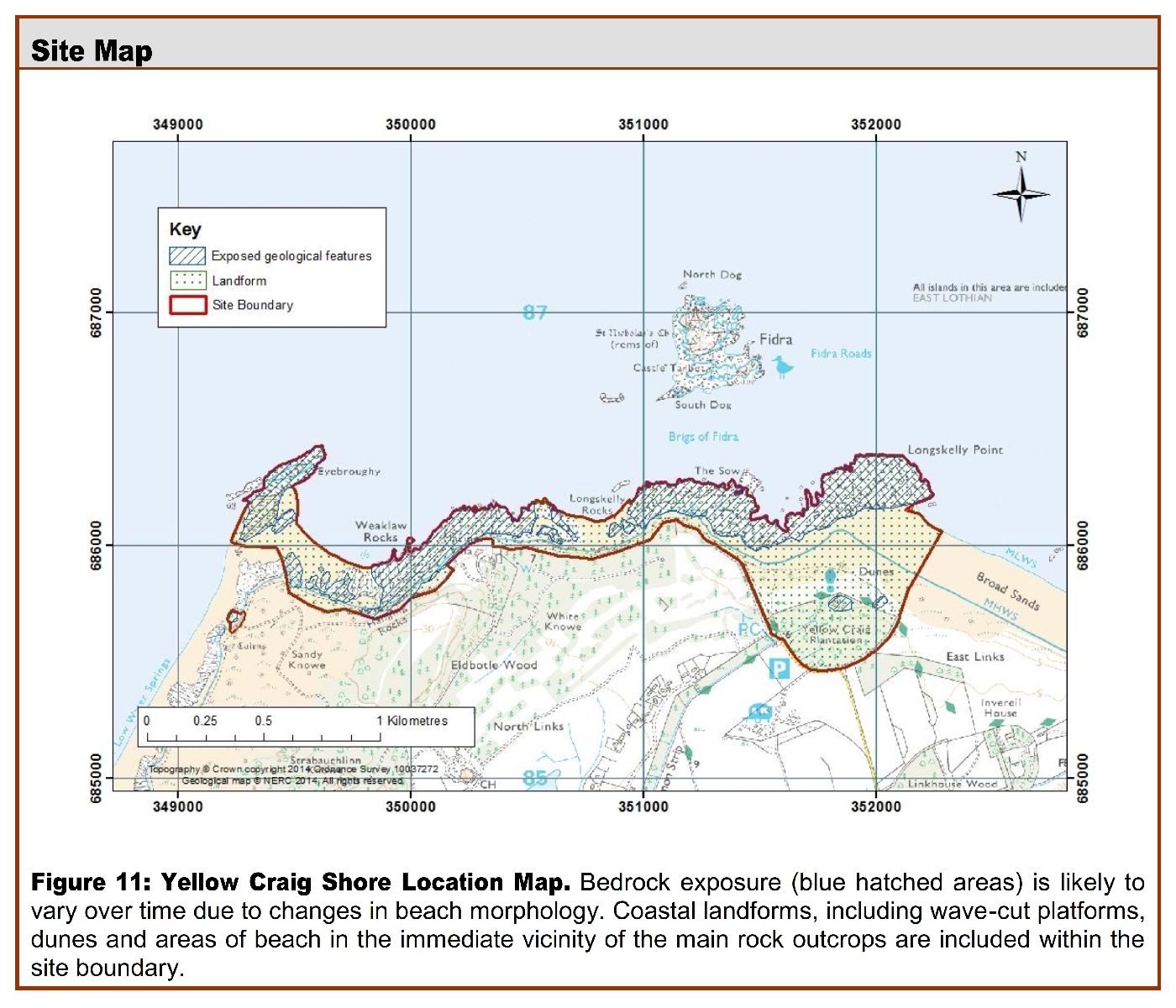
(Figure 11) Yellow Craig Shore Location Map. Bedrock exposure (blue hatched areas) is likely to vary over time due to changes in beach morphology. Coastal landforms, including wave-cut platforms, dunes and areas of beach in the immediate vicinity of the main rock outcrops are included within the site boundary.
Site description
Background and site area
The stretch of coastline between Yellow Craig to the east and Eyebroughy to the west is located to the west of North Berwick. The Broad Sands beach to the north of Yellow Craig is a popular place for walkers and tourists, and there are a number of walking trails and golf courses along the coast to the west.
Sedimentary rocks
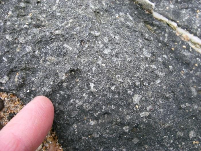
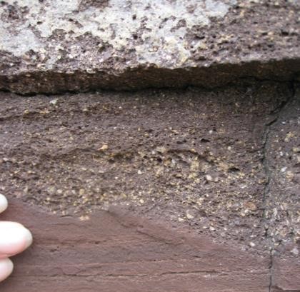
Sedimentary Rocks of the Gullane Formation are exposed in the western part of the site. These rocks comprise a sequence of reddened cementstones, siltstones and mudstones, with sparse dolomitic and tuff beds. The siltstones and mudstones are finely bedded, and the cementstones display a characteristic orthogonal fracture pattern (ELC_6_P1).
Volcanic rocks
The majority of the rocks exposed along the Yellow Craig shore are extrusive volcanic rocks of the Garleton Hills Volcanic Formation. The volcanic rocks at this site comprise, from oldest to youngest, sequences of basalt, mugearite, trachyte tuff and trachyte, and vents of tuff and breccia formed by the explosive extrusion of lavas of varying composition from volcanoes and volcanic vents.
Yellow Craig Hill, at the eastern edge of the site, is composed of an olivine-microporphyritic, fractured, black basalt which forms part of the Yellow Craig Plantation Plug. There are excellent views from the top of this small hill (a roche moutonnee) toward Fidra and the Broad Sands beach. To the north-east of Yellow Craig Hill are exposures of volcanic breccia (also part of the Yellow Craig Plantation Plug) composed of a brown-grey tuff containing rounded bombs and baked angular blocks (ELC_6_P3).
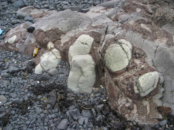
The intertidal rocks of Longskelly Point are composed of an intrusive sheet of fine-grained olivine- basalt, partially vesiculated, with weak polygonal jointing (ELC_6_P4). To the west, a plagioclase-macrophyric basalt (historically known as the Markle Basalt) flow is exposed along the coast. The basalt contains numerous large (<7mm) feldspar phenocrysts (ELC_6_P5), and has a gnarled and knobbly appearance along the shore. It is also cut in multiple places by calcite veins, and autobrecciated in the upper part of the flow (ELC_6_P6).
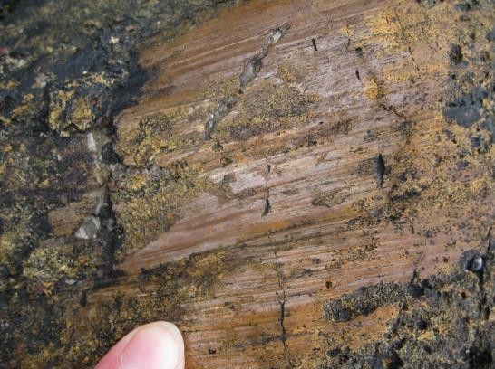
Overlying the plagioclase-macrophyric basalt is a fissile, dark grey-purple, fine-grained mugearite riddled with calcite veins and vugs. It contains occasional feldspar phenocrysts <4mm in size, and amygdales filled with calcite <2cm in diameter. There is localised iron staining along fractures within the mugearite, and excellent examples of concentric iron bands surrounding a core of bleached mugearite (ELC_6_P7), likely representing the weathered top of a mugearite flow within the sequence. The mugearite contains in places rip up clasts of the underlying Markle basalt caught up as the lava flowed across the surface of the older flows.
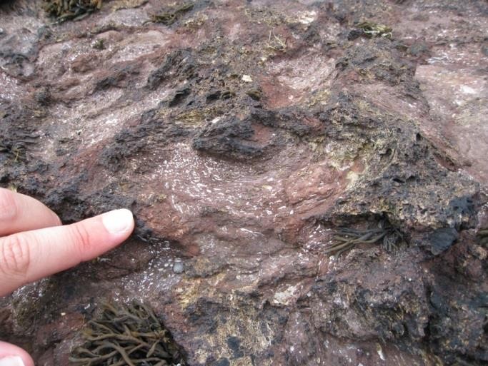
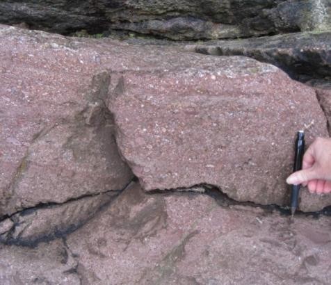
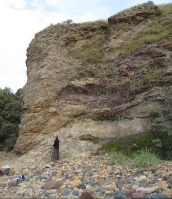
The mugearite is stratigraphically overlain by a trachytic tuff, formed by the deposition of ash following an explosive volcanic eruption. The contact between this tuff and mugearite is clearly defined on the coast to the north of Marine Villa, and is traceable for approximately 150 m along the intertidal platform to the west. At the contact, the mugearite displays an irregular, slaggy amygdaloidal flow top (ELC_6_P8) and is much reddened from its typical dark grey-purple, suggesting weathering of the lava top after emplacement. The overlying red - green trachytic tuff is bedded, with coarse agglomeratic beds and fine ash beds (ELC_6_P9). The coarser volcanic breccia beds locally truncate finer grained (ashy) units, suggesting that mass flows were active during deposition of the tuff (ELC_6_P10). Good exposures through the tuff sequence can be found in low cliffs at the high water mark near Marine Villa.
Bedded, yellow-brown tuffs and breccias containing dolomitic fragments form the Weaklaw Vent, exposed at the west of the site. Volcanic vents such as this are likely to have emplaced the locally surrounding lavas and tuffs.
Structural geology
Minor folds are visible within the dolomite tuff and dolomitic units of the Gullane Formation (ELC_6_P2), thought to be related to a nearby fault. There are multiple slickenlined planes visible within the trachytic tuff, particularly in the lower parts of the unit (ELC_6_P12). These slickenlined planes are also thought to be related to the fault also responsible for folding of the Gullane Formation rocks. Abundant calcite veins cross cut the mugearite and markle basalts, filling in fractures which probably formed soon after cooling of the basalt flows.
Quaternary deposits and landforms
Rock exposures along the coast comprise erosional cliffs and wave-cut platforms, interspersed with sandy beaches. Blown sand (dunes) form significant features across much of the site, particularly so at the west end of Broad Sand, and to the south of the bay between Weaklaw Rocks and Eyebroughy. A raised beach and glacially smoothed rock exposures are found to the north-east of Yellow Craig Hill.
Access and additional information
Access to the coastline is tide dependant, as most of the rocks are covered at high tide. The John Muir Way passes through the Yellow Craig Plantation. Access from the Yellow Craig Plantation car park is easy and the path can be followed to the beach, or to the top of Yellow Craig hill. There is a good network of paths surrounding the hill. The shoreline can be walked along either on the sandy beach, or if the tide is high, a rough track in the dunes adjacent to the shore. At the Yellow Craig Plantation car park there are interpretation boards describing the flora and fauna of Yellow Craig. The interpretation boards also describe the area’s historical links with Robert Louis Stevenson who was inspired the small islands in the Firth of Forth visible from Yellow Craig (namely Fidra).
Stratigraphy and rock types
Age: Lower Carboniferous
Formation: Gullane Formation
Rock type: Sandstone, siltstones, mudstones, occasional tuffs and dolomites
Age: Lower Carboniferous
Formation: Garleton Hills Volcanic Formation
Rock type: Trachytic tuff, trachyte, mugearite, plagioclase-macrophyric basalt.
Age: Carboniferous
Formation: Southern Scotland Dinantian Plugs and Vents Suite
Rock type: Tuff and breccia, olivine-macrophyric basalt
Assessment of site: access and safety
Road access and parking Good access from car park located at Yellow Craig Plantation. There are also public toilets available at the car park.
Safety of access Easy access to the shore but all visitors should be aware of the tide times when planning a visit, as most of the exposures are only visible at low tide.
Safety of exposure The rocky exposures have an uneven surface and are often slippery with seaweed. Stout footwear is recommended. The site is exposed to the open sea and the weather forecast should be checked before visits. Some of the exposures are found within low cliffs where potentially loose material may fall, therefore care should be exercised.
Access Access along the foreshore/beach, there are numerous footpaths around the site from the car park.
Current condition The rocks can be covered in barnacles and seaweed. Rocks exposed at the high water mark are mostly free of vegetation, but contain patches of lichen which cover discrete features.
Current conflicting activities None
Restricting conditions Tide: many of the geological exposures are located in the intertidal range and are therefore covered at high tide.
Nature of exposure Intertidal and beach exposures.
Assessment of site: culture, heritage & economic value
Historic, archaeological & literary associations Robert Louis Stevenson took inspiration for his book ‘Catriona’ from the nearby islands of Fidra and Lamb, and many people believe Fidra was the inspiration for his ‘Treasure Island’. Robert Louis Stevenson also used Marine Villa, a house on the coast in the centre of the site, as the location for his short novel ‘The Pavilion on the Links’.
Aesthetic landscape Coastal
History of earth sciences John Muir Way passes through Yellow Craig Plantation
Economic geology No known association
Assessment of site: geoscientific merit
|
Rarity |
Quality |
Literature/collections |
Primary interest |
| Lithostratigraphy |
Regional |
Excellent |
|
X |
| Sedimentology |
Local |
Poor |
|
|
| Igneous/Mineral/Metamorphic Geology |
Regional |
Excellent |
|
X |
| Structural geology |
Local |
Good |
|
|
| Palaeontology |
|
|
|
|
| Geomorphology |
Local |
Good |
|
|
Site geoscientific value
The site comprises a complete sequence of extrusive lavas, volcanic tuffs and volcanic vent material, allowing interpretation of the subaerial volcanic environment during the Carboniferous.
Yellowcraig Shore provides an excellent example of Carboniferous extrusive volcanic rocks with regional lithostratigraphical significance.
Assessment of site: current site usage
Community The easy access to the shore and the shore walkway is used regularly by locals. The John Muir Way passes through Yellow Craig Plantation which attracts visitors from further afield.
Education The site displays a variety of features suitable for amateur geologists to study a sequence of igneous rocks representative of a series of volcanic eruptions. This site is an excellent locality for educational fieldwork. The geodiversity of this site could be further promoted by a series of on-site interpretation boards, geo-trail and distribution of geological leaflets.
Assessment of site: fragility and potential use of the site
Fragility Weathering/erosion; development of coastal defences may affect the geodiversity
Potential use On site interpretation, on site geo-trail, school and higher education, research
Geodiversity summary
This site contains a good variety of geological features associated with volcanic strata. It exposes a sequence of the Lower Carboniferous Garleton Hills Volcanic Formation, along with a small section of the overlying sedimentary Gullane Formation. Features of the volcanic rocks seen indicate the emplacement mechanism and different phases of volcanism, allow interpretation of a sequence of eruption types. The coastline is attractive and has easy access. There are possibilities for adding geological interpretation to this site, especially at the car park of Yellow Craig Plantation, and on top of Yellow Craig Hill.
(ELC_6_P1) Intertidal exposure of reddened cementstones with a charactersitic orthogonal fracture network. Photo is looking to the north. © BGS, NERC.
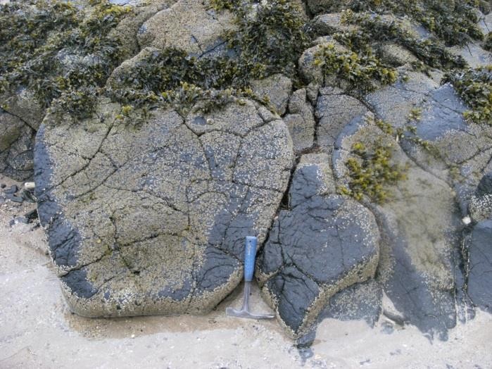
(ELC_6_P2) Subtle folding is found within the dolomitic and tuffaceous layers of the Gullane Formation. It is thought the folding is related to a nearby fault. Seaweed and barnacles largely obscure the outcrop in the intertidal zone. Photo is looking toward the west. © BGS, NERC
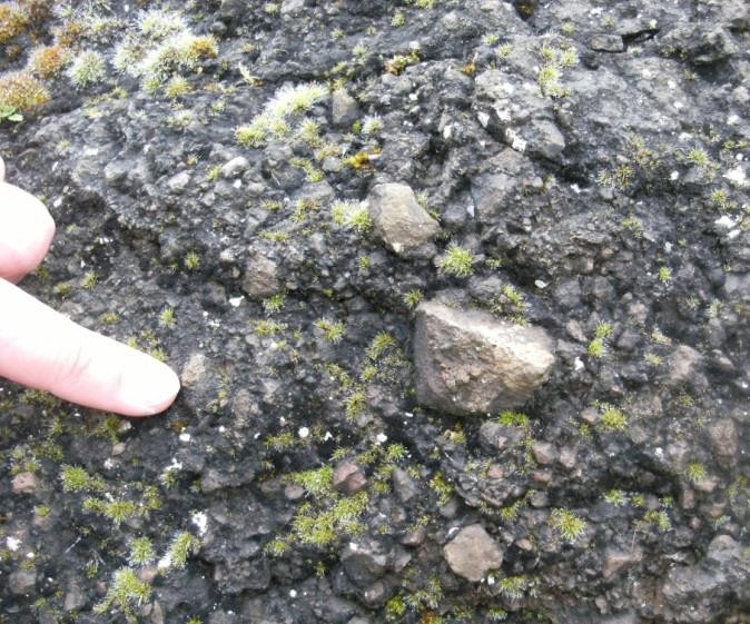
(ELC_6_P3) The breccia of the Yellow Craig Vent is a brown-grey tuff, containing baked angular clasts of volcanic material, such as those pictured above. © BGS, NERC.
(ELC_6_P4) Polygonal fracturing within the basic intrusion of Longskelly Point. The basalt here displays well formed vesicles, relict gas bubbles which have been preserved after the basalt cooled deep underground. © BGS, NERC
(ELC_6_P5) Detail of feldspar phenocrysts within the plagioclase-macrophyric basalt. The plagioclase phenocrysts are set within a fine grained groundmass, suggesting before this lava was emplaced, it cooled in two phases – a rapid cooling (forming miniscule crystals in the groundmass), and a slower, prolonged cooling (forming plagioclase feldspars). © BGS, NERC.
(ELC_6_P6) Example of mineralised autobrecciation at the top of a lava flow of the plagioclase-macrophyric basalt. Autobrecciation occurs when a new lava flow rumbles over the top of a pre-existing one, picking up loose or unsolidified material and rolling it along beneath the new flow. This zone is also susceptible to mineralization, due to the large pore spaces left during such a process. © BGS, NERC
(ELC_6_P7) Concentric iron bands rim a bleached core of iron-depleted mugearite. Note the unaltered grey-purple mugearite outsite the iron concreations. The concentric iron- banding is produced by segregation of iron oxide. There are also zones of calcite mineralisation within the iron bands. © BGS, NERC
(ELC_6_P8) The top of the mugearite is excellently exposed, displaying the irregular, amygdaloidal slaggy top of the flow. Examples of these slaggy tops are seen today in volcanic areas such as Hawaii and Iceland. The top of a lava flow is susceptible to mineralization, due to increased pore space following gases escaping through the top after emplacement. At the locality, mineralisation of the vesicles is found (white specks in photo above). © BGS, NERC
(ELC_6_P9) Low cliffs expose excellent sections through the bedded trachyte tuff succession, such as the one pictured above. The unit coarsens upwards, and is composed of beds a few cm thick ranging from very fine material (ash) to coarse material (agglomeratic). © BGS, NERC
(ELC_6_P10) Agglomeratic units within the trachytic tuff truncate underlying ashy units, suggesting as the agglomeratic units were emplaced, it scoured out the pre- existing ash unit, formed from a previous eruption. © BGS, NERC.
(ELC_6_P11) A cliff section at the Hanging Rocks forms the edge of the Weaklaw Vent, where the yellow-brown tuffs and breccias cross cut the reddish trachytic tuff sequence and overlying trachyte lava flow, which form the cliff in the right of the photo . Photo looking toward the east. © BGS, NERC
(ELC_6_P12) Example of a polished slickenlined plane within the trachytic tuff. Such slickenlined planes, in this cast mineralised by calcite, are numerous throughout the tuffs, thought to relate to a nearby larger fault. The slickenlines in the tuff indicate a normal sense of motion. © BGS, NERC
References