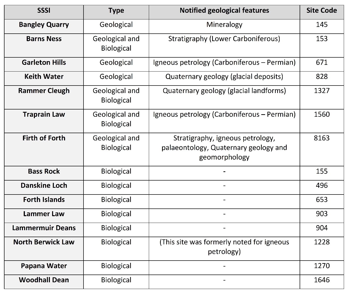
5 Summary
A total of 30 geological sites were visited and assessed across East Lothian, and are recommended as Local Geodiversity Sites. Combined, the sites represent a wide range of geological and geomorphological features, including excellent examples of geological strata and landforms that characterise the geology and landscape of Southern Scotland as well as unique sites of international importance for geological research
East Lothian has rich geodiversity and strong historic associations between its people and its landscape and resources. Many of the geodiversity sites could be enhanced to encourage visitors and students to learn more about how the geology and geomorphological processes influence the form and nature of the regions landscape.
| Site No. | Feature Type | Feature(s) | Overall Rating: Quality | Overall Rating: Rarity | |
| Gala Law | Bedrock exposure | Moderately good sedimentology and palaeontology | Local lithostratigraphy and paleontology | ||
| Burn Hope | Bedrock exposure | Great Conglomerate Fm | Excellent geomorphology, good lithostratigraphy and sedimentology | National geomorphology, regional lithostratigraphy | |
| Gin Head (nr Tantallon Castle) | Bedrock exposure | Ballagan Fm | Excellent palaeontology | International paleontology | |
| Dunbar Shore | Bedrock exposure | Kinnesswood Fm, volcanic vents, Ballagan Fm, Devonian rocks, Geomorphology | Excellent igneous geology, sedimentology and geomorphology | Regional lithostratigraphy, sedimentology, igneous geology and National Quaternary and coastal geomorphology | |
| North Berwick Shore | Bedrock exposure | Garleton Hills Volcanic Fm, volcanic vents, Aberlady Fm | Excellent igneous geology | Regional igneous geology and lithostratigraphy | |
| Yellow Craig Shore | Bedrock exposure | Garleton Hills Volcanic Fm, volcanic vents, Gullane Fm | Excellent lithostratigraphy and igneous geology | Regional lithostratigraphy and igneous geology | |
| Old Markle Quarry | Bedrock exposure | Garleton Hills Volcanic Fm | Good igneous geology | Regional igneous geology | |
| Blaikie Heugh – Balfour Monument | Bedrock exposure | Garleton Hills Volcanic Fm | Moderately good igneous geology | Regional/national igneous geology | |
| Kippielaw Quarry | Bedrock exposure | Garleton Hills Volcanic Fm | Poor igneous geology | Local igneous geology | |
| Dirleton Castle | Bedrock exposure | Garleton Hills Volcanic Fm | Excellent igneous geology | Local igneous geology | |
| Craigs Quarry | Bedrock exposure | Garleton Hills Volcanic Fm | Moderately good igneous geology | Local igneous geology | |
| Peppercraig Quarry | Bedrock exposure | Garleton Hills Volcanic Fm | Poor igneous geology | Local igneous geology | |
| Gullane Shore | Bedrock exposure | Gullane Fm, igneous sills, Quaternary landforms | Excellent sedimentology | Regional lithostratigraphy | |
| Kilspindie | Bedrock exposure | Lower Limestone Fm, Aberlady Fm, igneous sill | Excellent paleontology | Regional paleontology and lithostratigraphy | |
| Prestonpans Shore | Bedrock exposure | Upper Limestone Fm, |
Excellent lithostratigraphy | Regional lithostratigraphy and paleontology |
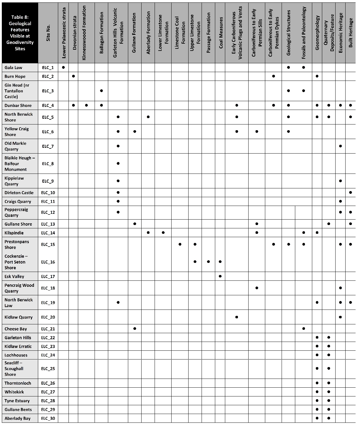
| 1 | 2 | 3 | 4 | 5 | 6 | 7 | 8 | 9 | 10 | 11 | 12 | 13 | 14 | 15 | 16 | 17 | 18 | 19 | 20 | 21 | ||
| Gala Law | • | • | • | |||||||||||||||||||
| Burn Hope | • | • | • | |||||||||||||||||||
| Gin Head (nr Tantallon Castle) | • | • | • | |||||||||||||||||||
| Dunbar Shore | • | • | • | • | • | • | • | • | • | • | ||||||||||||
| North Berwick Shore | • | • | • | • | • | • | • | |||||||||||||||
| Yellow Craig Shore | • | • | • | • | • | |||||||||||||||||
| Old Markle Quarry | • | • | ||||||||||||||||||||
| Blaikie Heugh – Balfour
Monument |
• | |||||||||||||||||||||
| Kippielaw Quarry | • | • | ||||||||||||||||||||
| Dirleton Castle | • | • | ||||||||||||||||||||
| Craigs Quarry | • | • | ||||||||||||||||||||
| 1 | 2 | 3 | 4 | 5 | 6 | 7 | 8 | 9 | 10 | 11 | 12 | 13 | 14 | 15 | 16 | 17 | 18 | 19 | 20 | 21 | ||
| Peppercraig Quarry | • | • | • | |||||||||||||||||||
| Gullane Shore | • | • | • | • | ||||||||||||||||||
| Kilspindie | • | • | • | • | • | |||||||||||||||||
| Prestonpans Shore | • | • | • | • | • | • | • | |||||||||||||||
| Cockenzie – Port Seton Shore | • | • | • | |||||||||||||||||||
| Esk Valley | • | |||||||||||||||||||||
| Pencraig Wood Quarry | • | • | ||||||||||||||||||||
| North Berwick Law | • | • | • | • | ||||||||||||||||||
| Kidlaw Quarry | • | • | ||||||||||||||||||||
| Cheese Bay | • | • | ||||||||||||||||||||
| Garleton Hills | • | • | ||||||||||||||||||||
| Kidlaw Erratic | • | • | ||||||||||||||||||||
| Lochhouses | • | • | ||||||||||||||||||||
| Seacliff–Scourghall Shore | • | • | ||||||||||||||||||||
| Thorntonloch | • | • | ||||||||||||||||||||
| Whitekirk | • | • | ||||||||||||||||||||
| Tyne Estuary | • | • | ||||||||||||||||||||
| Gullane Bents | • | • | ||||||||||||||||||||
| Aberlady Bay | • | • |
Key to columns
| Site No. | |
| 1 | Lower Palaeozoic strata |
| 2 | Devonian strata |
| 3 | Kinnesswoood Formation |
| 4 | |
| 5 | |
| 6 | |
| 7 | |
| 8 | |
| 9 | |
| 10 | |
| 11 | |
| 12 | Coal Measures |
| 13 | Early Carboniferous Volcanic Plugs and Vents |
| 14 | Carboniferous to Early Permian Sills |
| 15 | Carboniferous to Early Permian Dykes |
| 16 | Geological Structures |
| 17 | Fossils and Paleontology |
| 18 | Geomorphology |
| 19 | Quaternary Deposits/Feature |
| 20 | Economic Heritage |
| 21 | Built Heritage |
5.1 Bedrock exposures
In total, 21 sites have been identified as local geodiversity sites for their bedrock exposures. The Lower Palaeozoic, Devonian and Carboniferous sedimentary rocks which underlie much of central and southern Scotland are well exposed in many places in East Lothian. The geodiversity sites display a wide range of features that are characteristic of these rocks, their relationships with associated extrusive and intrusive igneous rocks, and regional patterns of deformation including folding and faulting.
The oldest sedimentary strata in East Lothian are turbidite sequences from the Lower Palaeozoic, which are exposed at the north margin of the Lammermuir Hills and the southern edge of the LC area
In the early Carboniferous, volcanic activity caused by upwelling of magma through the crust resulted in the formation of extrusive igneous rocks including lavas and tuffs of the
Cessation of volcanism in the East Lothian area during early to mid-Carboniferous times brought renewed deposition of sediments in a range of environments including terrestrial fluvial systems, swampy forests, deltas and shallow seas. In strata of the
Intrusion of igneous rocks in to the sedimentary strata occurred during the late Carboniferous to early Permian with the formation of numerous sills and dykes that can be seen in many of the coastal exposures, and in inland quarries such as Pencraig Quarry
Five sites were noted for their palaeontological value, of which two are of international significance. At Cheese Bay
5.2 Quaternary and Recent deposits and landforms
The topography across much of inland East Lothian is dominated by landforms sculpted by glacial erosion of the resistant volcanic rocks of the
The lower ground is extensively mantled by a variable cover of glacial till which is well exposed in the Keith Water SSSI (Gordon & Sutherland, 1993). Erratic boulders, including metamorphic rocks of Highland origin, commonly occur along the coast and are particularly well displayed on the shore platforms where they have been washed out from the till. Good examples occur at Aberlady Bay
The vast quantities of meltwater produced by the melting of the last ice sheet formed distinctive assemblages of landforms, including meltwater channels cut in bedrock, and mounds, ridges and terraces of sand and gravel on the lower ground. Particularly good examples of meltwater channels occur at Rammer Cleugh SSSI (Gordon & Sutherland, 1993), around Kidlaw and between Garvald and Innerwick. Associated glacifluvial deposits, including kame terraces and ice-marginal lake deltas, occur along the northern flanks of the Lammermuir Hills from Humbie to Oldhamstocks and in the region of Tynemouth to the county boundary. Some of the best examples of glacifluvial landforms at High Latch/Longyester (Sissons, 1958) have either been removed by sand and gravel quarrying or lie within an area where there is planning consent for further extraction.
As the last ice sheet receded, relative sea-level rose and the sea invaded the lower parts of the coastline, forming raised shorelines and extended estuaries at Aberlady Bay and along the lower Tyne. Relative sea level then fell but rose again during the early Holocene before falling to its present level. These changes are represented by raised beaches and staircases of raised shorelines, for example at Gullane Shore
Excellent examples of depositional coastal systems are also found in East Lothian, including the sand flats and dune systems at Gullane Bents
Geomorphological activity has also continued inland during the Holocene. Gullying is widespread in the Lammermuir Hills, notably represented at Oldhamstocks Burn GCR site and by the development ‘badland’ topography at Burnhope
5.3 Geodiversity and community
The form of the landscape of East Lothian, particularly the hills and coastal headlands formed of ice-moulded igneous rock, has been central to the settlement and development of the region’s towns and villages. The strong relationship between the geology and landforms, and the location of military sites and harbours can be seen at Dirleton Castle
The historic use of the area’s geological resources is also indicated at the geodiversity sites. Several of the bedrock exposures have been historically quarried for road metal (e.g. Kippielaw Quarry
Many of the geodiversity sites are located within areas that are used for recreation and/or associated with scenic areas popular with tourists. Several also are located partially or wholly within areas that are protected for their biodiversity or ecology as Local Nature Reserves as at Aberlady Bay
Several of the sites have significant associations with past or current scientific research; the region has been at the forefront of research into volcanology, Carboniferous depositional environments, lowland glaciation, coastal processes and now tetrapod evolution for over a century.
5.4 Limitations and potential further assessments
The geodiversity sites identified and assessed in this study represent additional sites that complement the existing protected geological SSSIs
Many of the geodiversity sites are part of dynamic erosional and depositional coastal systems. In addition to natural changes in landform morphology and the extent of bedrock exposures that may arise due to ongoing erosion or deposition, the geodiversity sites may be affected by climate or sea level change. The ‘soft’ depositional sand flats and dune systems of coastal sites (such as Gullane Bents, Aberlady Bay and the Tyne Estuary & Belhaven Bay) are likely to be most susceptible to such changes, and these may also be at risk from intrusive land management practices. In mitigation of the risks, however, these geodivesity sites are coincident with areas that are already well protected and managed for the importance of their biodiversity and ecosystems. As far as possible, the management of these sites should aim to maintain the natural processes.
Inland quarry sites are susceptible to natural degradation through vegetation growth and weathering, but may be more at risk from waste tipping and, in some cases, development. Sandstone quarries at Gullane, reportedly the source of local stone for Dirleton Castle and other local buildings are now degrade and show no exposures. A survey of building stones and local quarry sites would help to identify, and if necessary protect, sources of local stone, providing important information relating to the preservation of local historic buildings.
The dominance of pastoral agricultural land in East Lothian is a positive aspect of the condition of inland landforms and is conducive to their long term preservation. The condition of landform features may be detrimentally affected by afforestation and development, which may obscure their morphology.
Sand and gravel extraction may also be a risk to areas of the glaciofluvial sand and gravel deposits that occur within the region. Nationally important examples of these deposits and associated meltwater channels are represented by features within the Rammer Cleugh SSSI. However, there are several other potentially regionally important examples in East Lothian which could be surveyed in future assessments. Some of the best remaining examples of glaciofluvial deposits occur at High Latch/Longyester, but these features lie within an area for which there is planning consent for further sand and gravel extraction. Depending on the final restoration conditions of the site, it may be possible to identify conservation sections in these glaciofluvial deposits at the end of working, providing an opportunity to enhance the geodiversity of the region.