Excursion 6 Corrie Burn
Key details
| Author | George E. Bowes |
| Themes | Sedimentary and volcanic rocks of Lower Carboniferous age and evidence for the Campsie Fault. |
| Features | The Clyde Plateau Lavas, Calciferous Sandstone Measures, Lower Limestone Group and |
| Maps | O.S. 1:50 000 Sheet 64 Glasgow B.G.S. 1:63 360 Sheet 30 Glasgow |
| Terrain | The ground is rough in places, with some steep banks; the streams are normally easily crossed on foot. |
| Distance and time | It is not necessary to cover the whole area in one visit. The minimum useful walking distance, say from Burnhead Farm to Locality 5 and back is about 3 km (2 miles) and this can be accomplished in two or three hours. The whole excursion entails about 6 km (4 miles) walking, and can be done easily in one day. |
| Access | From the A803, at |
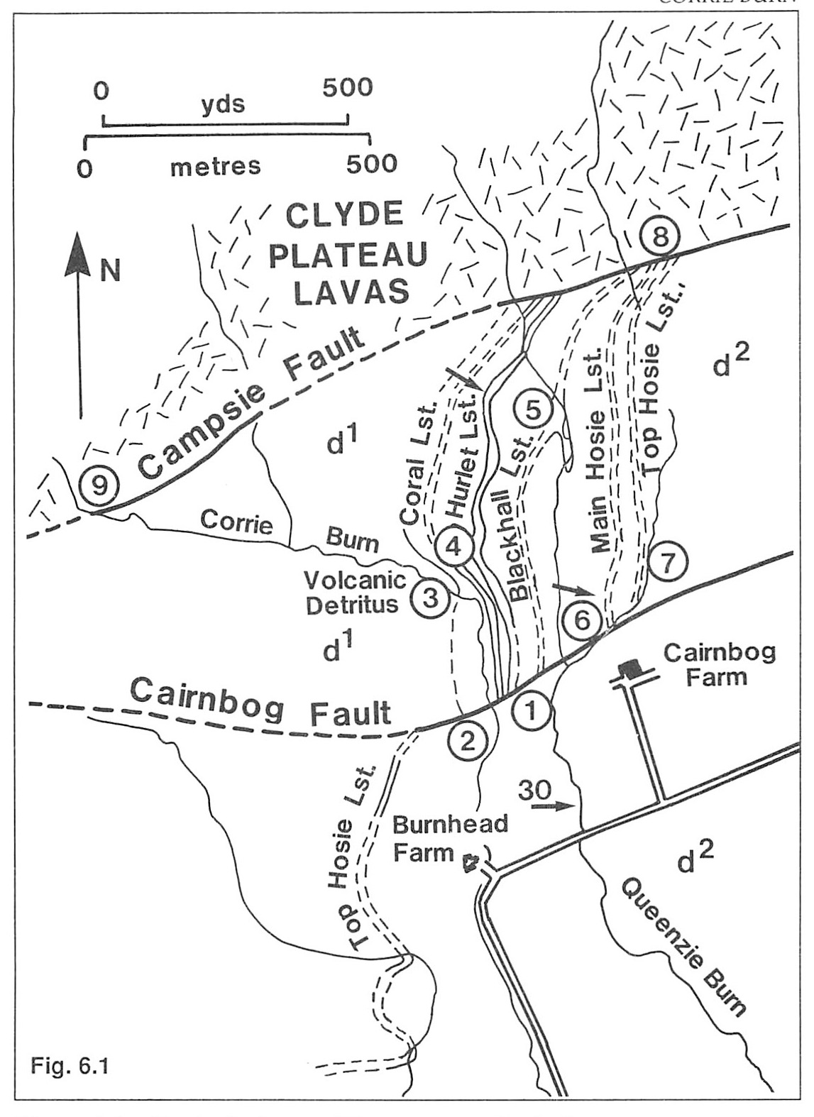
Locality 1. (Figure 6.1) : Limestone Coal Group
About 100 m west of Cairnbog Farm masonry of the entrance to an old mine is visible in the undergrowth a few metres up the west bank of the Queenzie Burn, indicating the proximity of coal-bearing rocks. Old maps show that the Kilsyth Coking Coal outcropped hereabouts. Some 90 m upstream, about 30 m below the confluence of the two branches of the Queenzie Burn, the Clayband Ironstone outcrops in the stream bed. The material is dark and shaly, but markedly heavier in the hand than the dark ferruginous shales forming the stream bank above it. The coal and the ironstone both belong to the
Locality 2. Cairnbog Fault
Beside the Corrie Burn some 250 m north of Burnhead Farm, occur the outcrops of massively bedded coarse somewhat ferruginous sandstone of the
Locality 3. Volcanic detritus
Volcanic Detritus is exposed where the Corrie Burn turns southwards, some 400 m north of Burnhead Farm. It comprises green and red-coloured lava and volcanic ash. Many of the fragments are rounded, and it is believed that this material has been transported by running water and deposited as a sediment. Towards its upper part, the volcanic detritus is interbedded with sandstones.
Overlying beds are now largely obscured, although some more resistant layers are exposed. Fragments of the richly fossiliferous Coral Limestone can be found in the burn.
Locality 4. The Corrie Burn (Hurlet) Limestone
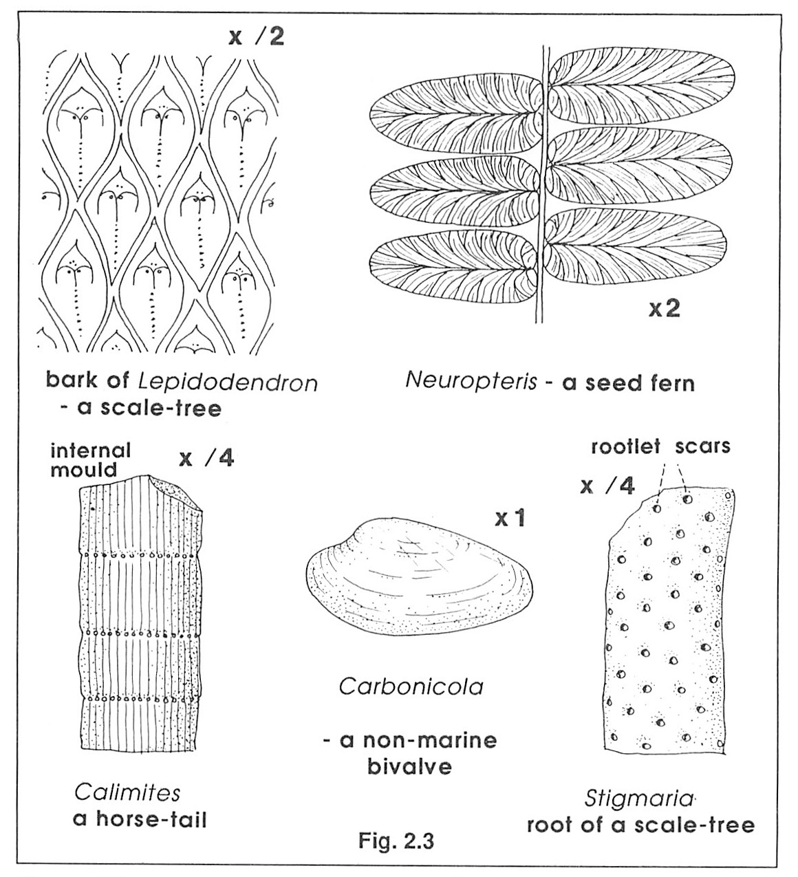
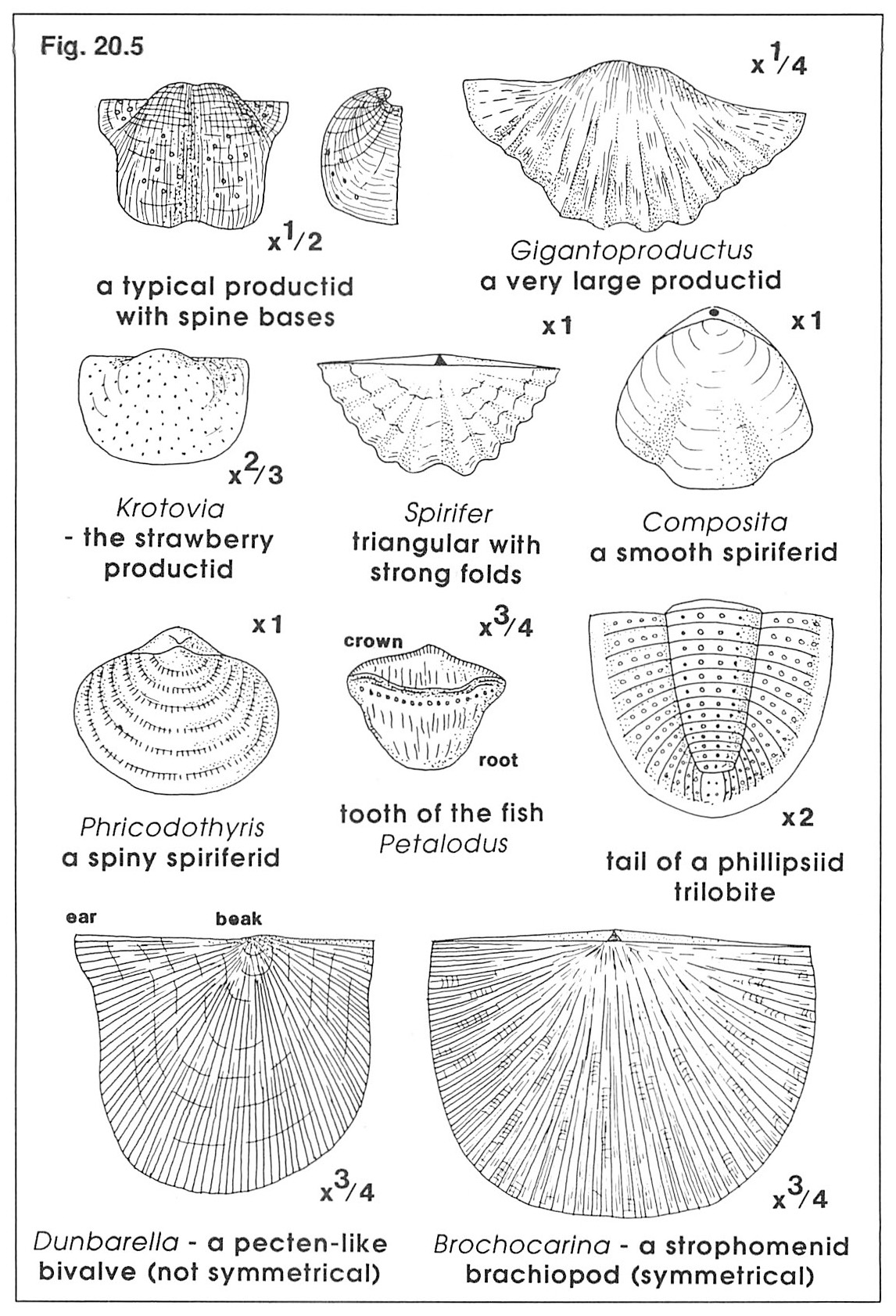
The Corrie Burn (Hurlet) Limestone is well exposed in a series of quarries along the strike of the bed, and yields brachiopods including productids, strophomenids, athyrids and spiriferids, corals such as Caninia and Lithostrotion, bryozoans, crinoid fragments and bivalves
Locality 5. The Blackhall Limestone
The
The dark shales (blaes) with abundant ironstone nodules which overlie the
The cliff is capped by a thin band of sandstone, fallen blocks of which may be found showing structures on the lower surfaces (sole marks) due to deposition upon a scoured or fluted surface, and some blocks also show evidence of mud-cracks.
Upstream, where the burn first reaches the
Locality 6. The Main Hosie Limestone outcrops in the eastern tributary of the Queenzie Burn
Eastwards, the burn follows the Cairnbog Fault so that sandstones overlying the Kilsyth Coking Coal occur in the south bank and sporadic outcrops of
Locality 7. Second Hosie Limestone and Top Hosie Limestone
The
The Second Hosie is somewhat arenaceous and more fossiliferous than the dark grey argillaceous Top Hosie. The intervening shales are also richly fossiliferous, yielding Sanguinolites and Posidonia. Further upstream there are outcrops of the shales overlying the
Localities 8 & 9. Campsie Fault
There is a distinct change in slope associated with the Campsie Fault which brings Lower Limestone strata into juxtaposition with Calciferous Sandstone Measures lavas. The feature can easily be traced westwards from the head of the eastern tributary of the Queenzie Burn (Locality 8 at
A short distance north of the fault small veins of barytes are present in the lava, and north and west of the fault a series of lava flows and ashes of varying composition are exposed (see
References
BENNIE, J. 1868. On the Surface Geology of Glasgow. Trans.geol. Soc. Glasg. 2, 100–115.
MACNAIR, P. and CONACHER, H.R.J. 1914. The Stratigraphy of the Limestones lying immediately above the Calciferous Lavas in the Glasgow District. Trans. geol. Soc. Glasg. 15, 37–50.
The Geology of the Glasgow District. 1925. Mem. Geol. Surv.
ROBERTSON, T. and HALDANE, D. 1937. The Economic Geology of the Central Coalfield , Area 1. Mem. Geol. Surv.