Excursion 9 Balmaha
Key details
| Author | B.J.Bluck |
| Themes | The principal reasons for visiting the Balmaha area are: 1. To examine the evidence for the presence of a terrane boundary within this general area. 2. To examine the evidence for the types of movements which have occurred along the Highland Boundary Fault and associated fractures, bearing in mild that movements along terrane boundaries are complex and diverse. There need not be a single phase of movement but a sequence of separate movements each of which may be different in nature and sense. 3. To examine the |
| Features | Conglomerates, alluvial fans, cross-stratification, unconformity, overlap, inverted cross-strata, cherts, serpentinite conglomerate, faults. |
| Maps | O.S 1: 50 000 Sheet 56 Loch Lomond & Inveraray. |
| Terrain | Lochside with muddy paths for first part of excursion; hillside for the later part. |
| Distance and Time | 4 km: walking time 5 hours. |
| Access | A809 to Drymen and the B837 from Drymen to Balmaha, On the A809 at Queen's View |
| Maps | O.S. 1: 25 000 Sheet NS 49/59 Buchlyvie Balmaha. B.G.S. 1: 63 360 Sheet 38 Loch Lomond. B.G.S. 1: 50 000 Sheet 38W Ben Lomond. |
Introduction
The Balmaha area has long been of considerable interest as being one of the most accessible places for viewing the Highland Boundary Fault–a fracture which has commanded a great deal of attention over the years. But over the past decade this fracture and its associated rocks have received renewed geological attention with the discovery that large-scale movements associated with terrane boundaries were to be found in the Caledonides (see Terrane Accretion in Western Scotland), and that they may be concentrated partly on the Highland Boundary Fault.
In this region it is possible to demonstrate the ways in which terrane boundaries may be analysed and the ways in which we are able to recognise terranes as being far travelled blocks, each of which has a history distinguishable from those now lying adjacent to it. Before discussing the localities to be visited at Balmaha, an introduction to the general problems of terrane analysis as demonstrated by these outcrops is now undertaken.
Terranes often travel such great distances that it is not possible to indentify the rocks on one side of a fault and look for their displaced equivalents on the other: i.e. the distances travelled by terranes often exceed the lateral extent of rock units. The other problem is that terranes often move along the strike of the beds, so that correlation across the faults is often not possible.
The problem posed in terrane identification at Balmaha is one of recognising differences in geological history between a basement and a sedimentary basin: the basement is the Dalradian and the sedimentary basin is the
The Dalradian block comprises a thick sequence of sandstones, limestones, lavas and shales laid down in the Late Proterozoic. After a period of folding which occurred before 590 Ma there followed a prolonged interval when the sequence was thickened and became hot and suffered fairly intensive metamorphism. At the present erosion level there is a changing mineralogy of these Dalradian metamorphic rocks as they are traced through the Highlands: generally low metamorphic grades occur in the south; and higher grades to the north. These changing grades are a response to the changing heat and pressure which occurred during their burial, so that in a very general way the rocks in the north were more deeply buried than those to the south. In the same general sense these metamorphic grades or zones lie roughly parallel with the Highland Boundary Fault. Superimposed on this general trend, there are some anomalies, the largest of which is that the rocks in the SW of the Dalradian belt underwent a cooler but higher pressure type metamorphism than the rocks to the NE.
After burial and metamorphism the whole sequence was subject to considerable uplift. Estimates of the burial-depths of rocks now at the surface range from 15 km in the south, along the Highland Boundary Fault to > 30 km in the central regions, so that these thicknesses of rock had to be removed to expose those rocks we can at present study at the surface.
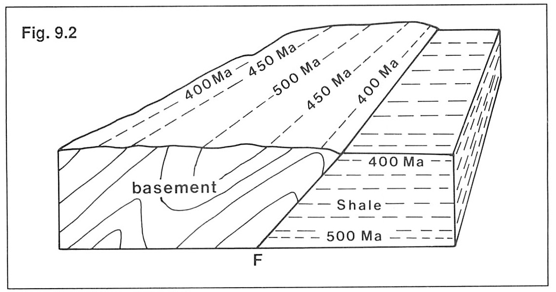
When were these overlying rocks removed? A clue to this comes from the radiometric dating of some of the metamorphic minerals. As the rocks are uplifted they cool, and certain of the minerals they contain record in their isotopic systems the time of cooling. By taking sections through the Dalradian basement one is then able to 'map-out' the cooling behaviour of the surface i.e. which metamorphic zone cooled first, second etc.
In the fictitious example given in
When basement blocks rise in this manner, they often yield a great deal of sedimentary detritus. The whole rock volume illustrated in the envelope in
If we find a sequence of rock which formed at the same time as an adjacent basement was known to have been rising and yielding sediment we would expect the sedimentary sequence to be dominated by coarse clas tic debris. We know therefore that a paradox exists when this relationship fails
In this situation we would suspect that the basement and basin did not lie adjacent to each other during the periods of their individual activity, but that both or one of them to be a terrane which has moved into its present position from some distance.
The Dalradian block was uplifted in Ordovician times from 515Ma–430Ma and a huge volume of sediment was lost from it. Rocks of the
Once a terrane boundary has been established one must then attempt to recognise the history of terrane assembling, i.e how and when did the blocks we now see lying adjacent to each other get into that position. There is good reason to believe that a substantial portion of the assembly record was poorly recorded, has been lost or is covered over by rocks emplaced by younger events. However there is also good reason to suspect that part of the later history of amalgamation is recorded in the sediments of the Old Red Sandstone and it is to these rocks we now turn to pick up the rest of the story.
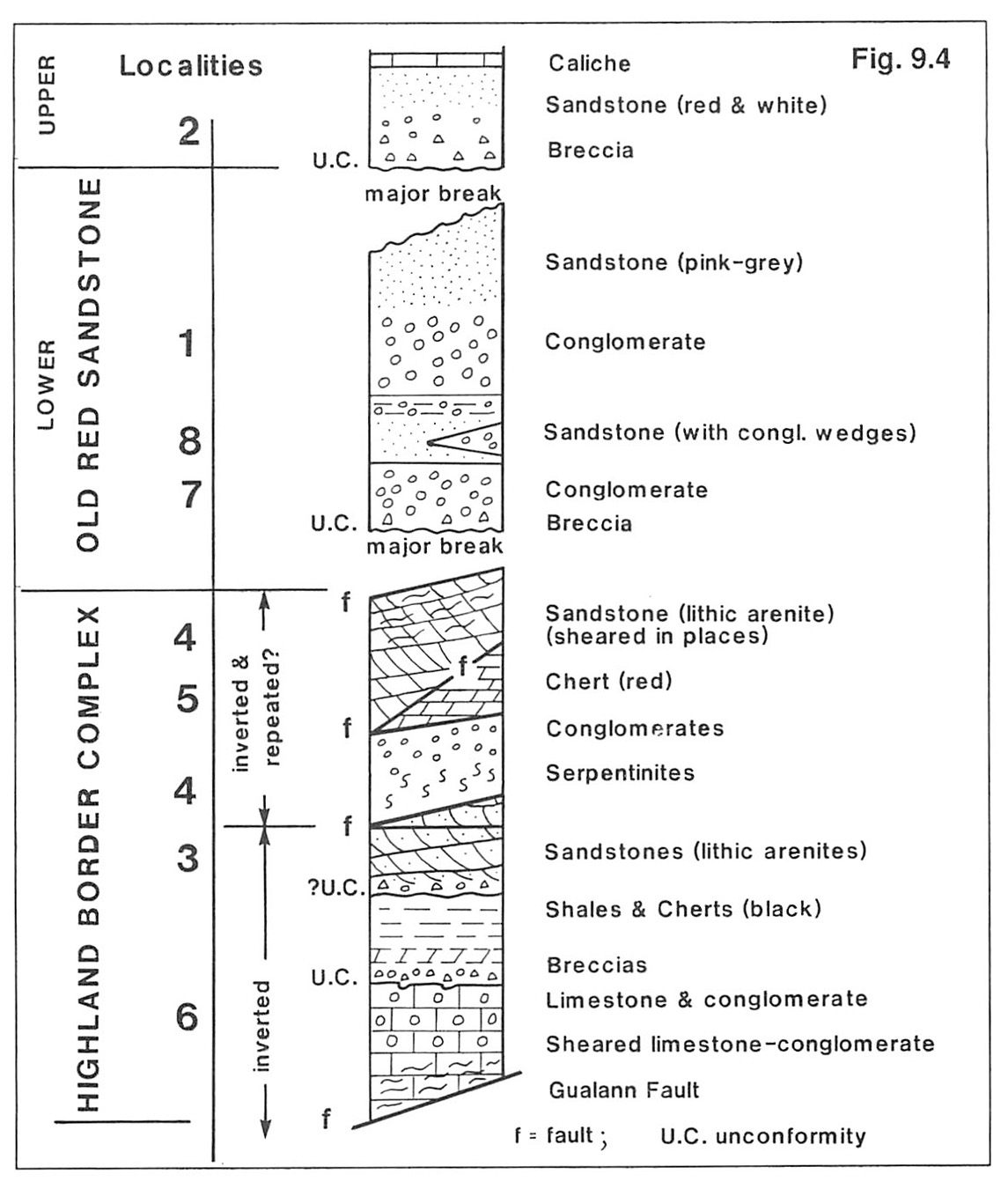
The Lower Old Red Sandstone rocks comprise a steeply dipping assemblage of conglomerates and sandstones which rest unconformably on the
When the whole Lower Old Red Sandstone assemblage is traced out laterally from near Aberfoyle in the NE to Inchmurrin in Loch Lomond in the SW it is seen as a sequence of overlapping lenses of conglomerate with interspersed sandstone
There are three distinctive stratigraphical units exposed south of the Dalradian block at Balmaha: The
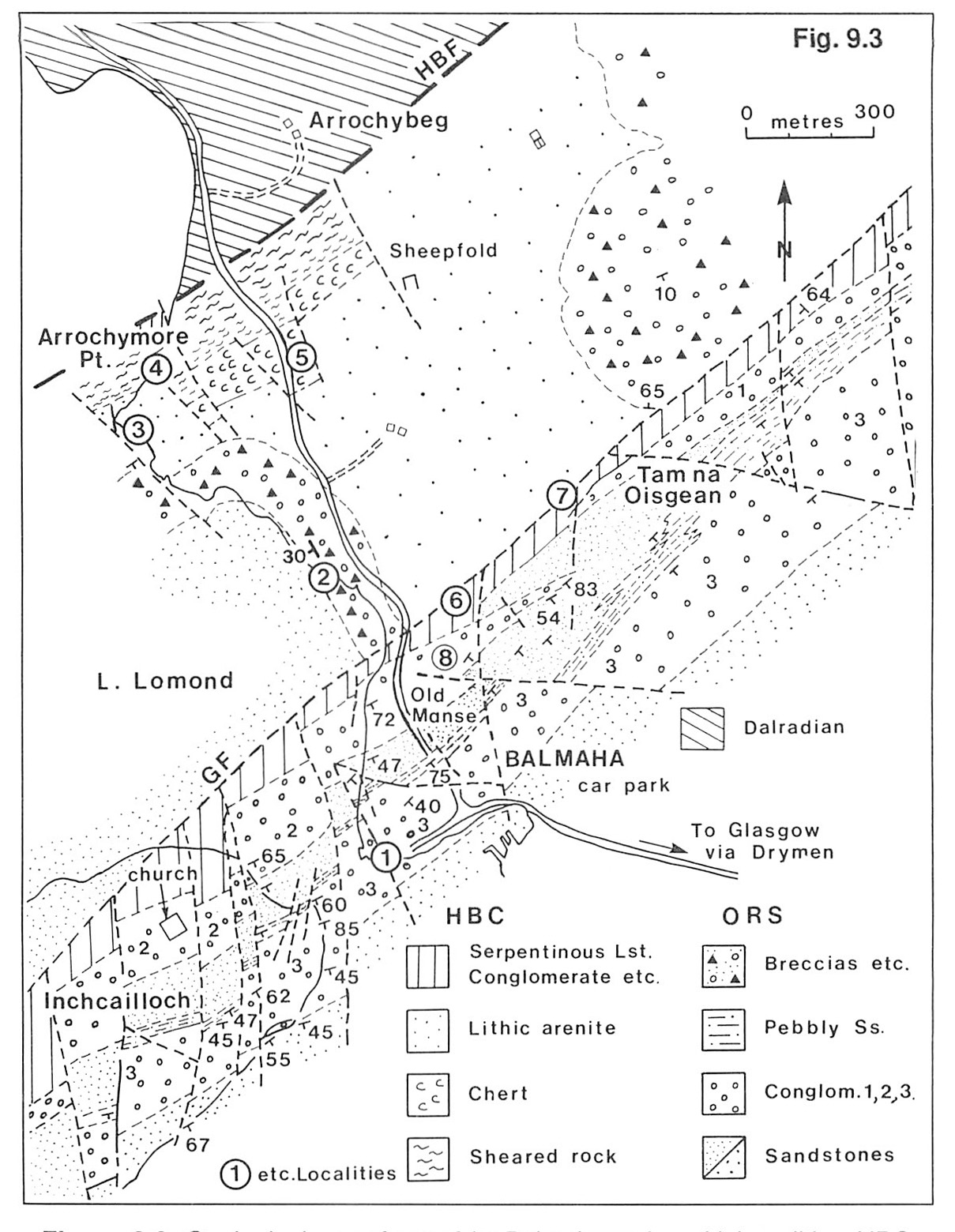
Locality 1. Balmaha Pier [NS 4155 9008] (Figure 9.3)
Lower Old Red Sandstone. Lower Old Red Sandstone conglomerates occur in the low ground to the immediate south of the pier and in the cliffs to the NW. The bay at Balmaha probably lies at the junction between the coarse conglomerates and the finer sandstones and siltstones which form most of the low ground around the southern end of Loch Lomond. The conglomerates contain fairly large clasts (up to 400 nun) mainly of quartzite, volcanic rocks mostly of intermediate type, together with a few orthoclase and biotite bearing granites. This conglomerate, no.3 in the local sequence
The conglomerates have a dispersal from the SE and NE, and taken as a whole, contain very well rounded clasts of tough quartzite and sometimes slightly less well rounded softer volcanic rocks. Some of the quartzite clasts have been broken and then re-rounded, indicating a provenance in a pre-existing, compositionally mature conglomerate comprising metamorphic clasts. The volcanic clasts may be first cycle. On the basis of the palaeocurrents in the conglomerates, this source block is thought to have existed within the Midland Valley and probably in the region which is now the Dalradian of the Southern Highlands.
At this stage it is not at all clear whether the Dalradian block along with the
The conglomerates are thought to have been deposited in bars built by braided streams. Generally speaking the thickness of the bar structures in these conglomerates increases with coarser grain size. From the study of the conglomerate lithosome shape and the distribution of clast sizes within it, it is concluded that these conglomerates formed in alluvial fans.
Follow the path north along the shore of the loch, passing a thick sandstone unit which underlies the conglomerate at the Pier, and head for the northern margin of the sandy bay.
Locality 2. Upper Old Red Sandstone
The conglomerates andbreccias exposed beneath these low-lying cliffs are assigned to the Upper Old Red Sandstone, partly on the basis of their upward transition into quartz-arenites and caliches, which normally characterize the top of the Upper Old Red Sandstone where it grades into known Carboniferous. The Upper Old Red Sandstone rocks are also typically a brighter red colour than the Lower, and in this region rest unconformably on the Highland Boundary Rocks (as can be seen south of Locality 3,
Clasts of 'grits', slates and other rocks of greenschist metamorphic facies and vein quartz comprise most of the rock-types in these breccias. This clast assemblage strongly resembles rocks now seen in the local Dalradian block to the immediate north and serve to remind us of the appearance of a typical conglomerate of Dalradian provenance. They are in sharp contrast to the conglomerates of the Lower Old Red Sandstone to the south. Sedimentary structures abound in these conglomerates, and fine examples of sand-shadows behind proud casts, imbrication and cross stratification in various scales are found. All these features indicate dispersal from the north, NW and NE, the direction in which the Dalradian is now seen to lie; the deposition was probably by braided streams.
From this outcrop it is clear that wherever the Dalradian block was with respect to the basin in which the Lower Old Red Sandstone accumulated, it was certainly close to the
Follow the path (West Highland Way) northwards to Arrochymore Point.
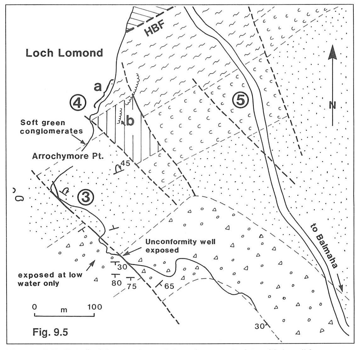
Locality 3. Highland Border Sandstones at the tip of Arrochymore Point (Figure 9.5)
Highland Border Sandstones are exposed near the tip of Arrochymore Point
These sandstones are probably of Caradocian age, for although no faunas have been obtained here, chi tinozoa from what are probably equivalent rocks near Aberfoyle are of that age.
Locality 4 Serpentinite and sheared rock
There are two main exposures to visit here
The small outcrop of serpentinite 4b
Follow the path NE for c. 200 m along the lochside to a car park, and then head south along the road (B837) back towards Balmaha. Locality 5 is an overgrown road cut on the western side of this road.
Locality 5. Red cherts belonging to the Highland Border Complex
Red cherts belonging to the
Walk along the road towards Balmaha, and in a shallow valley where the stream crosses the road (there is a field used as a car park here), a stile on the north side of the stream and opposite the car park allows access to a muddy footpath which winds through the trees and up the hill. The first ridge (i.e. furthest north) is distinctive because of its brown coloured soil.
Locality 6. Serpentinite conglomerate and breccias of the southern 'serpentinite'
The rocks comprising this hill are mainly breccia, conglomerate and a sheared mixture of carbonate and serpentinous rock which may be a sheared conglomerate with serpentinite pebbles in a carbonate matrix. In places the breccias and conglomerates are very distinctive and are formed of very well rounded clasts of serpentinite, basic rocks and sometimes sub-rounded quartz grains almost all of which are monocrystalline. On the continuation of this ridge to the shore at the lochside, distinctive marbles and conglomerates, normally underwater, have yielded a range of lithologies including dolerite, gabbro, spilite and well rounded clasts of quartz-arenite, and metaquartzite. Some of these metaquartzite clasts are > 300 mm in length and have ages of 1863Ma, which dates the uplift in the metamorphic block from which they were derived. This metamorphic block is substantially older than the Dalradian block, so the clasts were derived from a metamorphic terrane of unknown affinities and of uncertain location (Dempster and Bluck 1989).
These rocks on the shore have also yielded chitinozoa which suggest an Arenig age, and it is from rocks with this type of lithology that Curry et al. (1982) and Ingham et al. (1985) recovered a definite Lower Arenig fauna at Aberfoyle. It is almost certain therefore that these rocks are Arenig in age. Because they contain ophiolitic debris, there must have been in this region an ophiolite which is older than the limestone. From data elsewhere (Dempster and Bluck 1991) this ophiolite may be c.540Ma or older.
Along the south-eastern face of this exposure are very small outcrops of red sandstone which map out into the overlying Old Red Sandstone (see
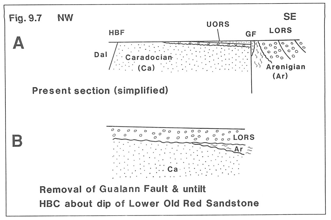
The serpentinite ridge is terminated along its northern margin by a fault which drops the Upper Old Red Sandstone down to the north. This fault is not the Highland Boundary Fault, as had previously been supposed: it is the Gualann Fault, named after a prominent hill on the NE termination of the conglomerate ridge. The Upper Old Red Sandstone steeply dips at the contact with this fault, as can be seen at the base of the ridge (see
Locality 7. Basal conglomerates and the overlapping fans
A line of old quarries, parallel with the ridge, exposes the conglomerates of the Lower Old Red Sandstone and rocks of the Ordovician
The conglomerate exposed in these quarries is the oldest Lower Old Red Sandstone conglomerate in this area; it is overlain by the sandstones of Locality 6, which in turn are overlain by a conglomerate (2 of
To the NW lies the low ground of the
From this vantage point the following features can best be appreciated:
1. The low ground immediately below the ridge comprises black shales and cherts which at low water in the loch are seen to overlie the Arenig rocks which make up the ridge upon which you are standing. These rocks are replaced to the NW in the sequence by the sandstones seen at Locality 9.3 near Arrochymore Point. In a general sense this sequence of Highland Border rocks is steeply dipping and youngs towards the NW. The Old Red Sandstone rocks are also steeply dipping, but to the SE, so that at the time of the deposition of the Old Red Sandstone the
2. As the Ordovician rocks of the
It is therefore clear that the Dalradian block was nowhere near the
3. The Upper Old Red Sandstone rocks form a thin cover over the
The disposition of the Upper Old Red Sandstone implies that the Upper Old Red Sandstone sequence thins from >1 km where it is exposed on the south limb of the Strathmore syncline to <100 m as one goes to the NW, and it thins against the Dalradian Block, which was therefore in place at this time. Moreover, if the base of the Upper Old Red Sandstone is projected to the NW, then in order to be in this position the Gualann Fault would need to have a vertical throw of at least 500 m. It also follows that the Strathmore syncline formed before the deposition of the Upper Old Red Sandstone since these rocks are clearly not part of that structure.
Locality 8. Edge of second conglomerate NE of Old Manse which at this point is surrounded by sandstone (Figure 9.3) .
This conglomerate, which makes up a distinctive small conical hill has the same composition and textures as the lowest seen at Locality 7. From this point, looking over The Old Manse it is possible to see the Island of Inchcailloch, and to the SE, the valleys cut into the faulted conglomerates. From SW to NE lies the ridge of conglomerate 3 which reaches its thickest development at Conic Hill to the NE.
From this position, from the examination of
1. The conglomerate bodies are lensoid and this can be partly seen on
2. There is evidently a sequence of conglomerate bodies which overlap each other to the SW
3. There is no evidence for a local Dalradian provenance. The source area included first cycle volcanic and plutonic rock and polycyclic quartzite; it did not include a metamorphic basement. The source extended from the SE to the NE and probably lay across the region now occupied by the Highland Boundary Fault.
4. Fanglomerate stacks of this kind can be modelled as forming in a basin, the SE, NW and NE margins of which were bounded by faults. One has to imagine the basin as a vertical extension of the present outcrop, so that its NW margin may have been 1 or 2 km in the vertical sense
5. The sedimentation of these rocks is effectively controlled by faults other than the Highland Boundary Fault—a considerable departure from former views (including my own !!). The basin margin of the ORS sediments was probably a fault and that fault would have been in a position some distance to the north of the present Highland Boundary Fault, and therefore positioned beneath the Dalradian block. Clasts at the top of the sequence are more angular than those at the base. This suggests that the source has been firstly stripped of its overlying conglomerates and that the feeder streams began eroding the original basement which, in this instance, comprised metaquartzite.
Conclusions
The principal conclusions to be drawn from this excursion are as follows:
The Dalradian and Highland Border blocks were not juxtaposed during the Ordovician; the Midland Valley, Lower Old Red Sandstone basin received sediment which was not derived from the local Dalradian; by Upper Old Red Sandstone times the two blocks (Midland Valley and
On a fine day it is well worth going up to the summit of Conic Hill; there is a splendid view in all directions and it is an ideal place (in good weather) to sit and muse on a majestic terrane boundary. To the SW, across Loch Lomond on a fine day it is possible to see the tall chimney stack of Inverkip power station, beyond which lies the northern peaks of Arran. To the SE it is possible to see through the gap of the Blane Valley, Tinto Hill (the Late Silurian felsite) and the highest point in the Midland Valley. Tinto lies just north of the Southern Upland Fault, so from this point the whole width of the Midland Valley is seen. The low ground running parallel with the strike of the conglomerates, and occupied partly by the southern end of Loch Lomond is made up of sandstones and siltstones which occur in the axis of the Strathmore syncline. The impressive line of hills immediately beyond the low ground of the Strathmore syncline comprise Upper Old Red Sandstone in the foothills and Carboniferous basalts in the higher ground. The distinctive conical hills are almost all Carboniferous volcanic plugs.
References
BLUCK, B.J. 1985. The Scottish paratectonic Caledonides. Scott. Geol. 21, 437–464.
BLUCK, B.J. and LEAKE, B.E. 1986. Late Ordovician to Early Silurian amalgamation of the Dalradian and adjacent Ordovician rocks in the British Isles. Geology 14, 917–919.
BLUCK, B.J., INGHAM, J.K. CURRY, G.B. and WILLIAMS, A., 1984. Stratigraphy and tectonic setting of the
CURRY, G.B., INGHAM, J.K., BLUCK, B.J. and WILLIAMS, A. 1982. The significance of a reliable Ordovician age for some Highland Border rocks in Central Scotland. J. Geol.Soc. 139, 451–4.
DEMPSTER, T.J. 1985, Uplift patterns and orogenic evolution in the Scottish Dalradian. J. Geol. Soc. 142, 111–128.
DEMPSTER, T.J. and BLUCK, B.J. 1989. The age and origin of boulders in the
DEMPSTER, T.J. , 1991. The age and tectonic significance of the Bute amphibolite,
HENDERSON, W.G. and ROBERTSON, A.H.F. 1982, The Highland Border rocks and their relation to marginal basin development in the Scottish Caledonides. J. Geol. Soc. 139, 433–450.
INGHAM, J.K. CURRY, G.B. and WILLIAMS, A. 1985. Early Ordovician Dounans Limestone fauna,