Excursion 32 Dob's Linn
Key details
| Authors | S. Henry Williams and James D. Lawson |
| Themes | Upper Ordovician and Lower Silurian graptolites and the international stratotype section of the Ordovician-Silurian boundary. |
| Features | Fossils: black shales: metabentonites: faults: inverted strata: landslip. |
| Maps | O.S. 1: 50 000 Sheet 79 Hawick & Eskdale B.G.S. 1: 63 360 Sheet 16 Moffat 1: 50 000 Sheet 16E Ettrick (dri ft) |
| Terrain | Steep grassy and scree-covered slopes plus a few narrow stream crossings. Care should be taken on unstable, slippery rock if venturing up to the higher localities. |
| Distance and Time | A short walk (approximately 1 km): 2 hours minimum on exposure. |
| Access | Dob's Linn is on National Trust land and is also part of the Moffat Hills SSSI. Although collection of a few specimens, particularly from scree, poses no problem, permission should be sought before extracting large amounts of material. |
Historical background
The name 'Dob's Linn' is derived from a 17th Century covenanter named Dobson, who used a ledge by the waterfall in the Linn Branch to hide from government forces. Graptolites were first recorded from Dob's Linn over one hundred years ago, although the earliest publications describing species from the
Most of Lapworth's new species were first described by Elles and Wood (1901–18), whose work he supervised. Following this major publication, no taxonomic or stratigraphic work was done at Dob's Linn for half a century, with the exception of Davies (1929) who included material from the locality in his revision of certain Upper Ordovician and Lower Silurian graptolites.
The dearth of publications was broken by Packham in 1962, who utilised specimens from the Birkhill Shale in an evolutionary study of Lower Silurian diplograptids. Following this, Toghill published several papers listing revised zonal assemblages for the Birkhill Shale (1968 a & b), and giving taxonomic descriptions and illustrations of graptolites from the top Lower Hartfell Shale and Upper Hartfell Shale (1970). Following several years of critical study, Ingham published a completely new geological map of Dob's Linn in 1979. Ingham's mapping permitted intensive collecting of the graptolite fauna from continuous sections: a series of papers was published by Williams which included taxonomic descriptions of the late Ordovician and earliest Silurian faunas, and biostratigraphic revision of the top Lower Hartfell to basal Birkhill Shale (Williams 1982a, 1982b, 1983; Williams and Ingham 1987). This work confirmed Lapworth's faith in graptolites as a critical biostratigraphic tool, and resulted in more precise definition of the zonal boundaries.
Geological setting
Dob's Linn lies within the central part of the Southern Uplands. This region is dominated by a monotonous series of mostly Silurian greywackes referred to the Gala Greywacke. These are underlain by the Upper Ordovician and Lower Silurian
The
The
The overlying Upper Hartfell Shale is composed mainly of nongraptolitic, pale grey-green shales and mudstones 28 m thick. Its lower boundary is marked by a transitional 3 cm interval of alternating pale grey and black shale laminae. Three groups of graptolitic black shale bands occur within the formation, named the Complanatus, Anceps and Extraordinarius Bands after their diagnostic zonal assemblages, indicative of the Dicellograptus annplanatus, Dicellograptus anceps, and
The Ordovician-Silurian boundary stratotype
The Ordovician System was introduced by Lapworth in 1879, in a successful attempt to solve the mid-19th Century debate between Sedgwick and Murchison; Lapworth established his stratigraphy primarily through the use of graptolites. During the 1960's it was recognised that despite most systems of the Geological Time Scale having been in international use for the past century, none had been properly defined.
In order to rectify this situation, the International Union of Geological Sciences (IUGS) established a Commission on Stratigraphy, who in turn set up a number of working groups to study the system boundaries and make recommendations regarding an international stratotype section for each. It was considered that any boundary stratotype should include an unbroken, continuously fossiliferous section across the relevant interval, have ease of access and the potential for palaeomagnetic, geochemical and radiometric studies. Once a stratotype had been decided, an imaginary 'golden spike' would be placed at the exact horizon and locality marking the defined, internationally-accepted boundary. The Ordovician-Silurian Boundary Working Group was established in 1974 to formally define the stratigraphic level and boundary stratotype location for the base of the Silurian System. During the next decade it received over fifty reports from geologists around the world (see Cocks and Rickards 1988); following much discussion, the choice for stratotype was narrowed down to two se[Graptolites were originally colonial, planktctions, namely Anticosti Island in eastern Canada, with a boundary based on conodonts, and Dob's Linn in southern Scotland, with a boundary defined using graptolites. Although both were well studied, richly fossiliferous and relatively complete, neither section provided a perfect candidate for the boundary stratotype. The succession on Anticosti Island is an essentially undeformed, shallow-marine limestone sequence rich in shelly macrofossils (e.g. trilobites and brachiopods) and conodonts, but with few graptolites. Dob's Linn is an oceanic shale sequence rich in graptolites, but with only rare examples of other fossils, and is structurally complex. Objections to choosing Dob's Linn as stratotype included the sparsity of nongraptolitic faunas (with only rare conodonts, trilobites and inarticulate brachiopods), and inadequacy for palaeomagnetic studies, while those against Anticosti Island included the likely presence of undetected breaks in a shallow marine sequence and difficulty of precise correlation with many Ordovician-Silurian boundary sequences. Following a series of formal ballots, Dob's Linn was finally ratified as the stratotype by the IUGS in 1985.
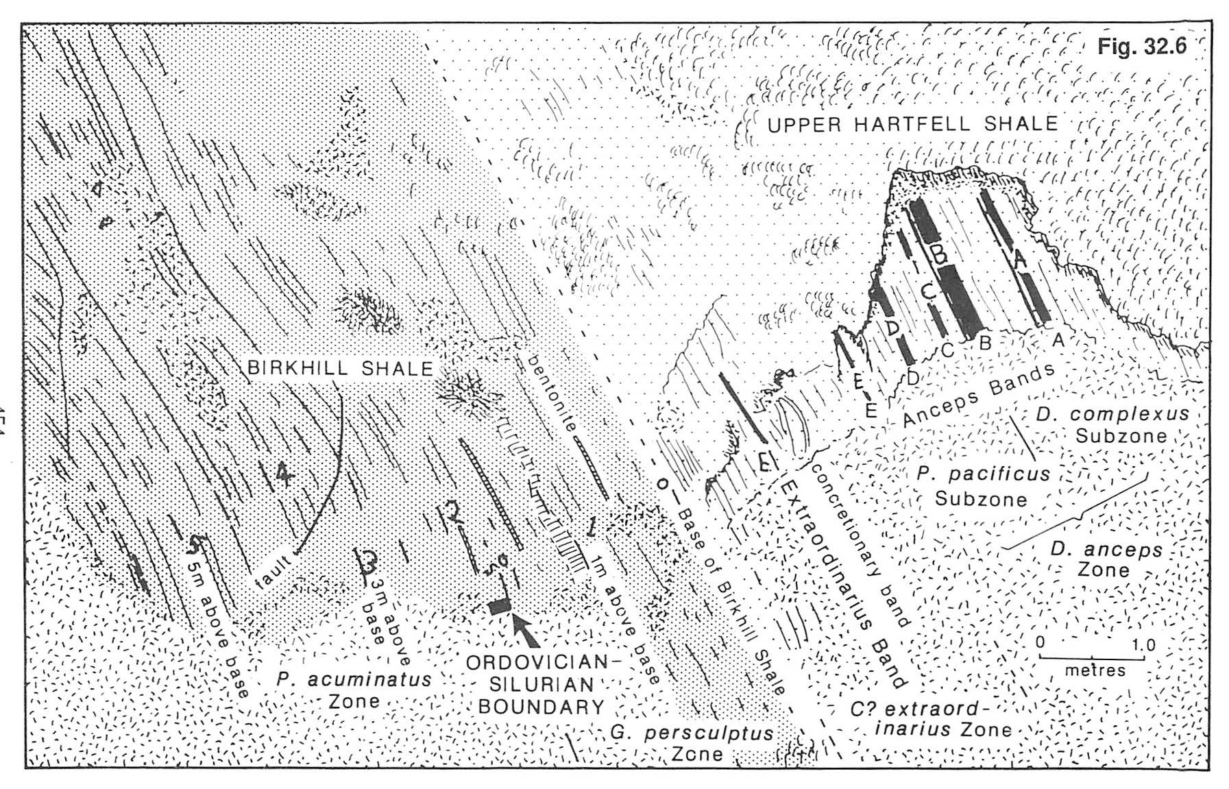
The Ordovician-Silurian boundary had historically been considered to lie at the base of the Birkhill Shale. This was, however, considered to be an unsuitable horizon at which to place a chronostratigraphic boundary, owing to a lithological change from unfossiliferous grey mudstone to graptolitic black shale and lack of major evolution in the graptolite fauna. The 'golden spike' was thus placed at the base of the P. acuminatus Zone, 1.6 m above the base of the Birkhill Shale in the Linn Branch section. This horizon is recognised by the first occurrence of Akidograptus ascensus and associated species, an event which may be correlated accurately in many sections around the world. A summary paper on Dob's Linn as stratotype was published by Williams (1988).
Itinerary
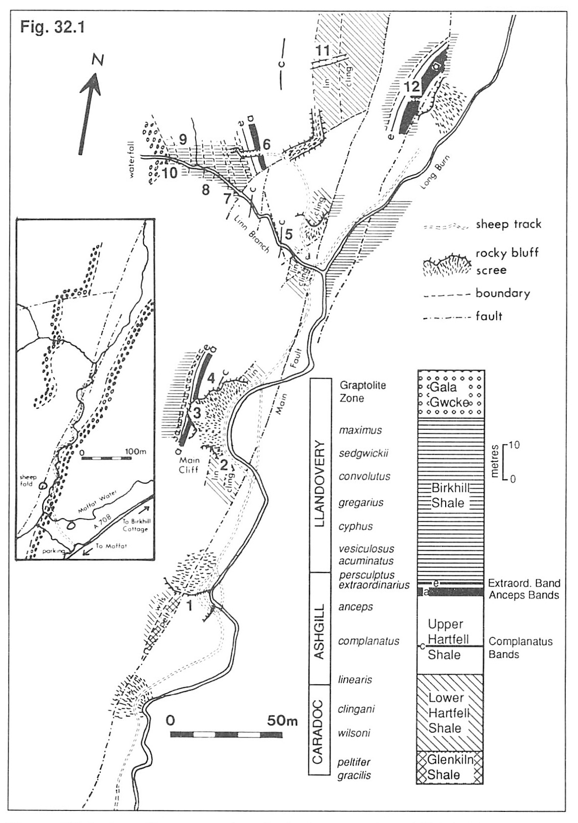
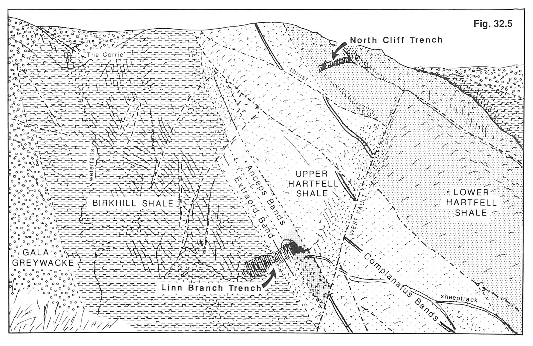
To get to Dob's Linn, travel to Moffat via the A74, then take the A708 Selkirk road from the town centre. The road travels along the side of the glaciated and U-shaped valley of the Moffat Water; the present small stream is a misfit which meanders around the broad valley floor, sometimes splitting and rejoining to give a braided pattern. There are also hanging valleys, the most famous and spectacular being at the Grey Mare's Tail with its lofty waterfall. Proceed 1 km beyond the Grey Mare's Tail car park, which is 16 km (10 miles) from Moffat, to a double lay-by on the left-hand side of the road,
From the lay-by, follow the poorly-defined sheep track into the bottom of the valley, then northwards for about 150 m (Figure 32 1). The first black shale scree slope traversed is derived from faulted Birkhill Shale.
Locality 1. Glenkiln Shale
Proceed to a small but prominent bluff which the track crosses after dividing; just to the left of this, under a thin cover of scree, is the only fair-sized exposure of Glenkiln Shale at Dob's Linn. It is not, however, recommended to stop here before visiting the other localities, as graptolites are difficult to find and poorly preserved due to the rather pale, cherty lithology. It might be worth collecting from this stop after seeing the other outcrops, when specimens of Dicellograptus, Dicranograptus,
Locality 2. Main Cliff
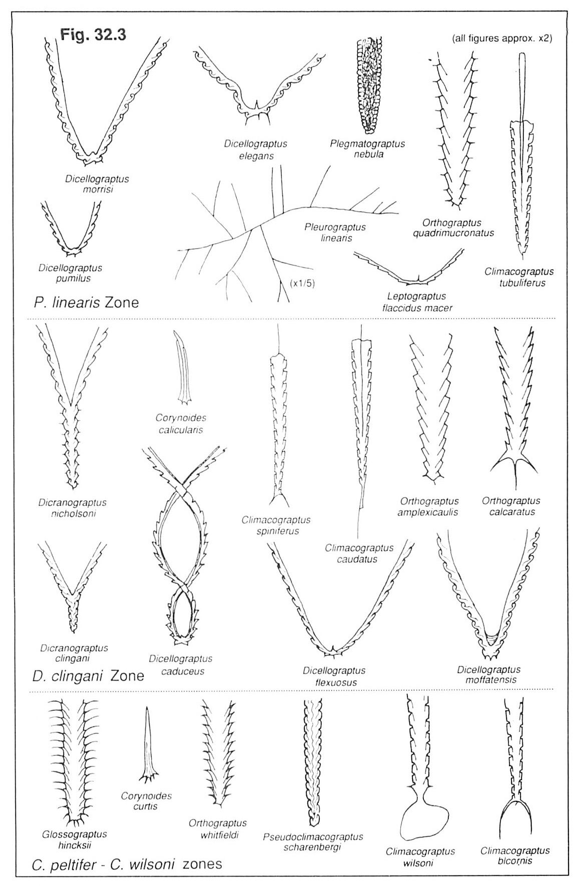
Lower Hartfell Shale. The first recommended stop is at the Main Cliff. Before studying the shales in detail, follow the track over to the right-hand bank of the stream and look across at the exposure, largely hidden by scree on the lower slopes. Note how the black Lower Hartfell Shale at the base, and Birkhill Shale at the top are separated by the paler grey Upper Hartfell Shale. At this locality the strata are dipping at about 45° and are the correct way up, while at all other parts of Dob's Linn the strata are dipping at a high angle and are inverted. The explanation is that the whole of the Main Cliff slumped and rotated during the Pleistocene; it is not a tectonic feature as assumed by early workers. The succession is heavily faulted, so detailed measured sections may only be constructed with extreme care. Now proceed to the lowest bluff just above the stream. This belongs to the Dicranograptus clingani Zone of the Lower Hartfell Shale and contains a fauna including Dicellograptus (D. caduceus, D. flexuosus, D. moffatensis), Dicranograptus (D. clingani, D. nicholsoni, D. rarnosus,),
Just above this is a second, slightly hollowed-out exposure.This belongs to the upper part of the Pleurograptus linearis Zone, and contains P. linearis, Leptograptus (L. capillaris, L. flaccidus macer,) Dicellograptus (D. carruthersi, D. elegans, D. morrisi, D. pumilus),
Locality 3. Main Cliff
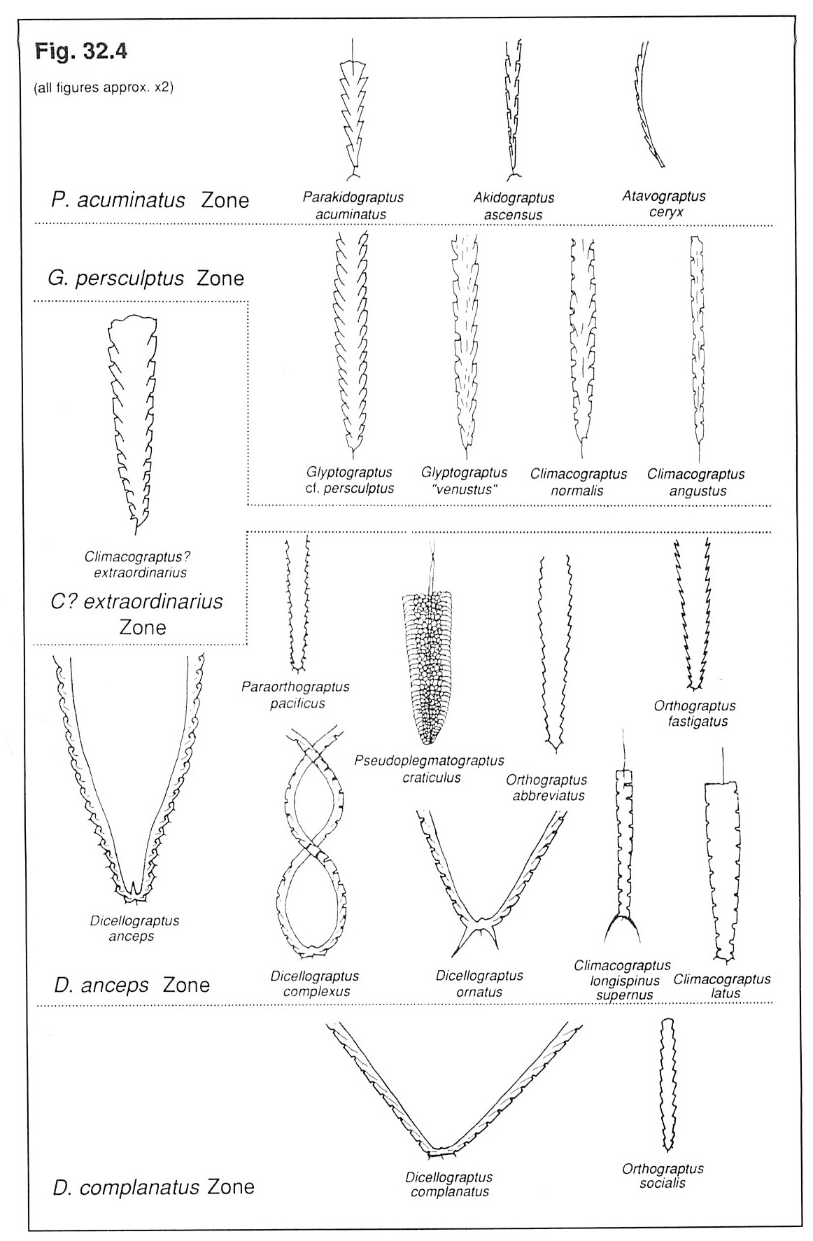
Anceps Bands. Climb the scree to the exposure of black shale and cream metabentonites in the top of the Upper Hartfell Shale. These are the five groups of Anceps Bands of the Dicellograptus anceps Zone, numbered A to E, and contain abundant Dicellograptus (D . anceps, D. complexus, D. minor),
The basal 1.6 m. of Birkhill Shale belong to the latest Ordovician G. persculptus Zone. It yields a low-density fauna consisting entirely of diplograptids, including Glyptograptus (G. avitus, G. cf. persculptus ' G. venustus'), and
Locality 4. Main Cliff Complanatus Bands
Now cross the scree of the Main Cliff without descending to the bottom. If a little time is spent, it should be possible to find the two black Complanatus Bands of the Dicellograptus complanatus Zone, bounded by pale grey shale.
These contain Dicellograptus (D. complanatus , D. minor),
Locality 5. Linn Branch
Proceed to where the main stream divides and turn into the left hand tributary, the Linn Branch. The first exposures of black shale in the hollow on the left bank of the stream belong to the D. clingani and P. linearis zones and contain similar faunas to those seen at Locality 2. Just upstream from this, the two Complanatus Bands seen at Locality 4 may be observed at the back of an excavation in the stream bank. These should not, however, be collected owing to their very limited outcrop.
Locality 6. Junction of the Linn Branch and Long Burn
Climb up the track to the trench visible from the junction of the Linn Branch and Long Burn (see
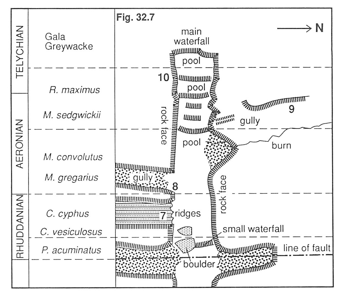
Locality 7. cyphus Zone
The Linn Branch burn provides a continuous section from the P. acuminatus to R. maximus zones, but most zonal boundaries are not easily recognisable. It is wisest, therefore, to collect from the central body of each zone at the numbered localities
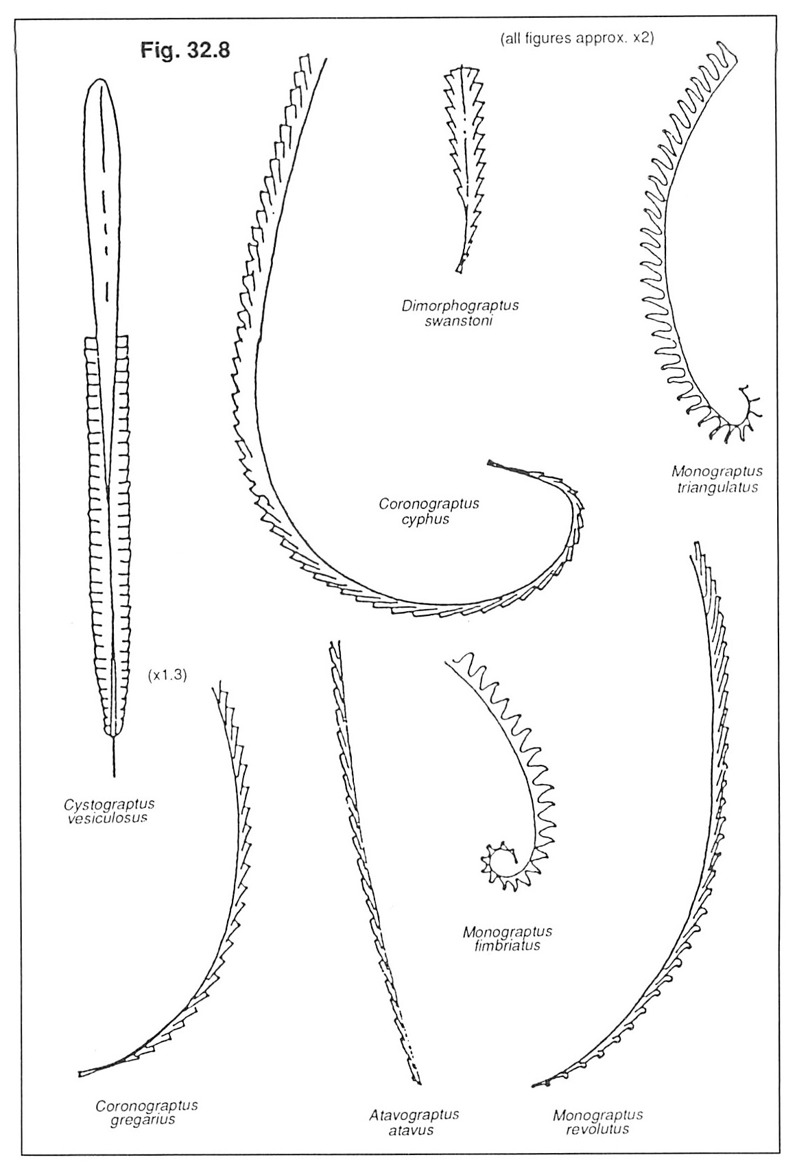
The graptolite assemblages from Locality 7 in the C. cyphus Zone (7.3 m of black shale) display the general characteristics of the C. vesiculosus–C. cyphus interval, i.e. the common occurrence of monograptids with simple thecae (e.g. C. typhus) and some with gently sigmoid thecae (e.g. Atavograptus atavus). The distinctive dimorphograptids with their short uniserial portion occur at this level but are not easy to find, although examples of the diplograptid genus
Locality 8. gregarius and convolutus Zones
The general characteristics of the middle Llandovery Coronograptus gregarius and Monograptus convolutus zones can be discussed together in terms of their general characteristics. The C. gregarius Zone comprises 7.9 m of black shale with thick nodular claystones and is best collected at Locality 9. The M. convolutus Zone is 5.35 m thick, and is represented by two intervals of richly fossiliferous black shale separated by barren grey mudstones; it can be seen at Locality 10 and on the opposite side of the gully. Monograptids with triangulate thecae (e.g.
Locality 9. sedgwickii and maximus Zones
The youngest characteristic graptolitic interval present at Dob's Linn comprises the Monograptus sedwickii and Rastrites maximus zones. The M. sedwickii Zone is 8.4 m thick, with 2 m of black shale sandwiched between lower and upper units of barren, grey mudstones. The R. maximus Zone is 6.55 m thick, composed mostly of grey mudstones and fine greywackes with a number of fossiliferous black shale bands. Locality 9 in the M. sedgwickii Zone shows the main characteristics of this division. Monograptids with hooked thecae (mostly M. sedgwickii become common, although triangulate forms still occur in the basal layers and monograptids with simple thecae (e.g. Pristiograptus regularis) persist
Locality 10. Gala Greywacke
Here the gradational transition from the Birkhill Shale to the Gala Greywacke occurs. It falls within the R. maximus Zone, the black shale bands yielding hooked, triangulate and simple monograptids, together with species of Rastrites which have long, isolate thecae.
Locality 11. North Cliff trench Lower Hartfell Shale
If time and energy allow, it is worth visiting the final two localities, although care must be exercised on the rather steep slopes. Locality 11 may be reached by climbing up the scree-filled gully on the down-stream side of the Linn Branch trench, or via the scree and grass-covered slopes above the junction of the Lunn Branch and Long Burn (see
Locality 12. Long Burn: Anceps Bands
This is another trench cut through the Anceps Bands, and is situated above a scree slope in the Long Burn. At this locality the succession is more than twice as thick as that in the Linn Branch (Locality 6). This apparently rapid change in depositional thickness is more easily understood when realising that the localities are separated by a major thrust (the Main Fault, see
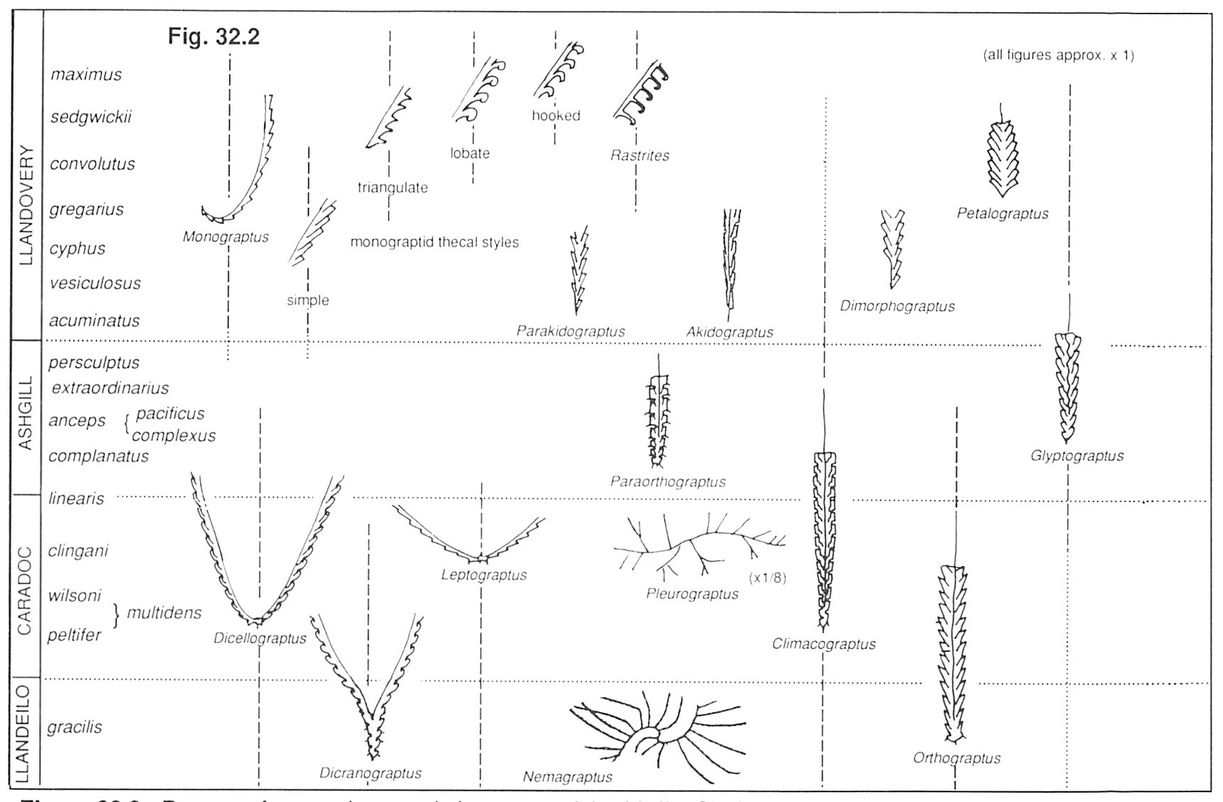
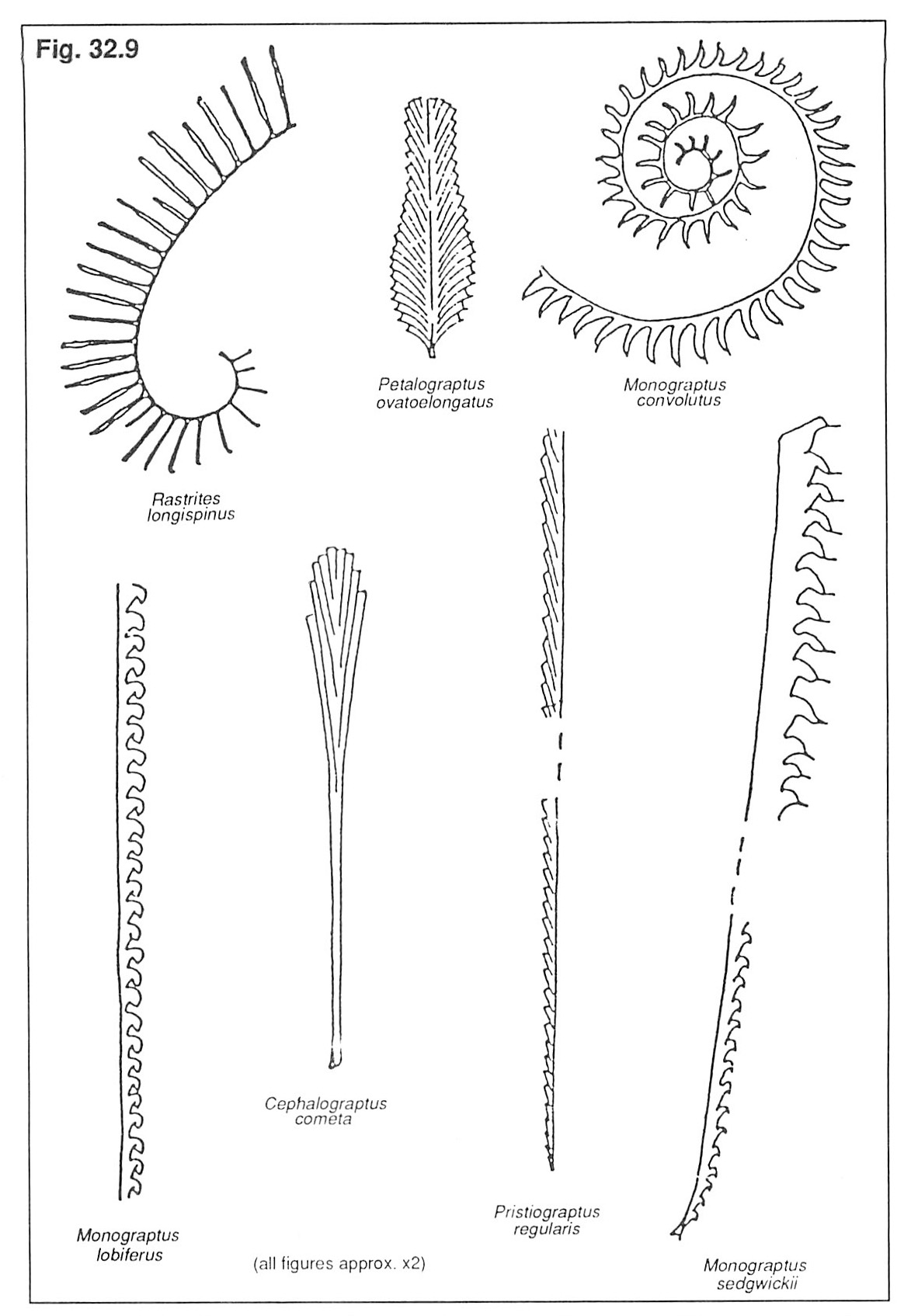
Identification of characteristic graptolite species
Graptolites were originally colonial, planktonic animals, which belonged to the invertebrate phylum Hemichordata. Their organic external skeletons, originally a series of tubes, are all that remain of the original animal. Identification of graptolites relies on:
- The overall form of the complete fossil (rhabdosome), including features such as number of branches (stipes), stipe attitude, width, etc.
- The nature of early development of the colony (seen at the proximal, normally spinose, end).
- The outline and spacing of the tubes (thecae).
In earlier publications, much emphasis was placed on the overall form and thecal outline when identifying genera. It is now believed that these features are often unreliable, partly because they are frequently affected by deformation caused during flattening of the cylindrical thecae, and partly because of tectonic stretching. More emphasis is therefore placed on proximal development, including position of thecae, nature of spines, etc. Unfortunately, such features are often difficult to observe in flattened, deformed specimens as normally found at Dob's Linn and in other black shale sequences, and many genera are currently being revised.
When identifying graptolite species, first look for overall form and distinctive proximal features, then finally check the thecal outlines. Remember that graptolite colonies grew continuously by budding, and while large specimens might have several hundred thecae, others may have died after growing only three or four, or with only the conical sicula present (which housed the first individual). Also be careful not to identify a single, broken-off stipe of a Dicellograptus as a Monograptus, and watch out for two or more rhabdosomes overlapping to give the false appearance of a different graptolites (e.g. two Monograptus stipes resembling a Dicellograptus). Good luck!
Dob's Linn for the amateur geologist
The amateur geologist should not be discouraged by the detailed biostratigraphy of the foregoing account, or by the difficulties encountered when identifying graptolites. Although not perhaps the most prepossessing of fossils, graptolites have proved to be of worldwide importance in establishing contemporaneity of strata in the older Palaeozoic rocks owing to their rapid evolution and diversification. Many of the species and zones at Dob's Linn can be recognised over much of the world; particularly close comparisons have been made recently with China, Siberia and Newfoundland.
Many sections yield graptolites slowly and reluctantly, but at Dob's Linn you cannot fail to find them in abundance and variety. Remember, however, that most professional geologists need to send their specimens to a very limited number of experts for accurate identification of species. Nevertheless, it is not difficult to recognise the more distinctive genera and the main thecal types of monograptids; a knowledge of these enables one to instantly distinguish between Ordovician rocks of Llandeilo, Caradoc and Ashgill age, and Silurian strata belonging to various divisions of the Llandovery Series (see
Most of the specimens you find will not be readily identifiable because of fragmentation, distortion or poor preservation. Look for specimens which are as large as possible but still show the early stages (sicula and proximal thecae), and use an elementary text book.
Refer to the foregoing account and start at Locality 2 at the base of the Main Cliff in the Lower Hartfell Shale. The graptolites tend to occur in bands with differing species components, so examine the black shales layer by layer. The abundant diplograptids can mostly be identified as Orthograptus or
These Caradoc rocks are characterised the world over by the presence of slender, gently or strongly curved, two-branched Leptograptus, the slender but stiff Pleurograptus with side branches, the V-shaped Dicellograptus, and the Y-shaped Dicranograptus. The latter genus is easier to find at the more precarious Locality 11.
Ascend the Main Cliff to Locality 3, or move to Locality 6 above the Linn Branch to collect from the Anceps Bands in the Upper Hartfell Shale. Although the fauna at this level is dominated by
At Locality 6, study the Ordovician-Silurian boundary. Note that it is not now taken in the formerly accepted position at the base of the Birkhill Shale where continuous black shale deposition began, but 1.6 m above where Akidograptus ascensus and Parakidograptus acuminatus appear; reasons for this change are discussed earlier in the text. Now descend to the stream and collect from the C. cyphus Zone at Locality 7
On both sides of the gully at Locality 8, collect from the C. gregarius Zone which yields an abundant and varied fauna. Monograptids with triangulate thecae are now common in addition to the simple forms. Isolate forms (Rastrites) and the distinctive Petalograptus are less common and need to be looked for carefully. Lobate monograptids appear in the higher layers. The small ridge with bedding planes exposed at Locality 9 is within the M. sedgwickii Zone, notable for the appearance of hooked monograptids, particularly the zone fossil. The transition from the Birkhill Shale into the overlying Gala Greywacke is visible at Locality 10.
Acknowledgements
References
BARNES, C.R. and WILLIAMS, S.H. 1990. The Ordovician-Silurian boundary. In BRIGGS, D.E.G. and CROWTHER, P.R. (eds.). Palaeobiology: a synthesis.. Blackwell, U.K.
DAVIES, K.A. 1929. Notes on the graptolite faunas of the Upper Ordovician and Lower Silurian. Geol.Mag. , 66, 1–27.
ELLES, G.L. and WOOD, E.M.R. 1901–18. A monograph of British graptolites. Palaeontogr. Soc. (Monogr.) clxxi & 539 p, 52 pls.
INGHAM, J.K. 1979. The Moffat area. In BASSETT, M.G. et al. Guidebook to field meeting„ Great Britain, March 30-April 11, 1979 , 42–46. Subcommission on Silurian Stratigraphy, Ordovician-Silurian Boundary Working Group, IUGS.
LAPWORTH, C. 1878. The Moffat Series. Q.J. geol. Soc. Lond. 34, 240–346.
LAPWORTH, C. 1879. On the tripartite classification of the Lower Palaeozoic rocks. Geol. Mag. 6, 1–15.
PACKHAM, G.H. 1962. Some diplograptids from the British Lower Silurian. Palaeontology 5, 498–526.
TOGHILL, P. 1968. The graptolite assemblages and zones of the Birkhill Shales (Lower Silurian) at Dobb's Linn. Palaeontology, 11, 654–668.
TOGHILL, P. 1968b. The stratigraphical relationships of the earliest Monograptidae and the Dimorphograptidae. Geol. Mag. 105 , 46–51.
TOGHILL, P. 1970. Highest Ordovician (
WEBB, B., RUSHTON, A.W.A and WHITE, D.E. (in press). Classical areas of British geology. Moffatdale and the Upper Ettrick Valley. British Geological Survey, London, H.M.S.O.
WILLIAMS, S.H., 1980. An excursion guide to Dob's Linn. Proc. geol. Soc. Glasgow 121/122 , 13–18.
WILLIAMS, S.H., 1982a. The late Ordovician graptolite fauna of the Anceps Bands at Dob's Linn, southern Scotland. Geol. et Palaeontol., 16, 29–56.
WILLIAMS, S.H., 1982b. Upper Ordovician graptolites from the top
WILLIAMS, S.H., 1983. The Ordovician-Silurian graptolite fauna of Dob's Linn, southern Scotland. Palaeontology 26, 605–639.
WILLIAMS, S.H., 1987. Stratigraphy and graptolite fauna of the D. complanatus Zone in Scotland. Scott. Jl. Geol. 23, 65–92.
WILLIAMS, S.H., 1988. Dob's Linn–the Ordovician-Silurian boundary stratotype. In COCKS, L.R.M. and RICKARDS, R.B. (eds.). The Ordovician–Silurian boundary. Bull. Br. Mus., nat. Hist. (Geol.) 43, 17–30.