2 Summary of geology
With special reference to localities selected for examination
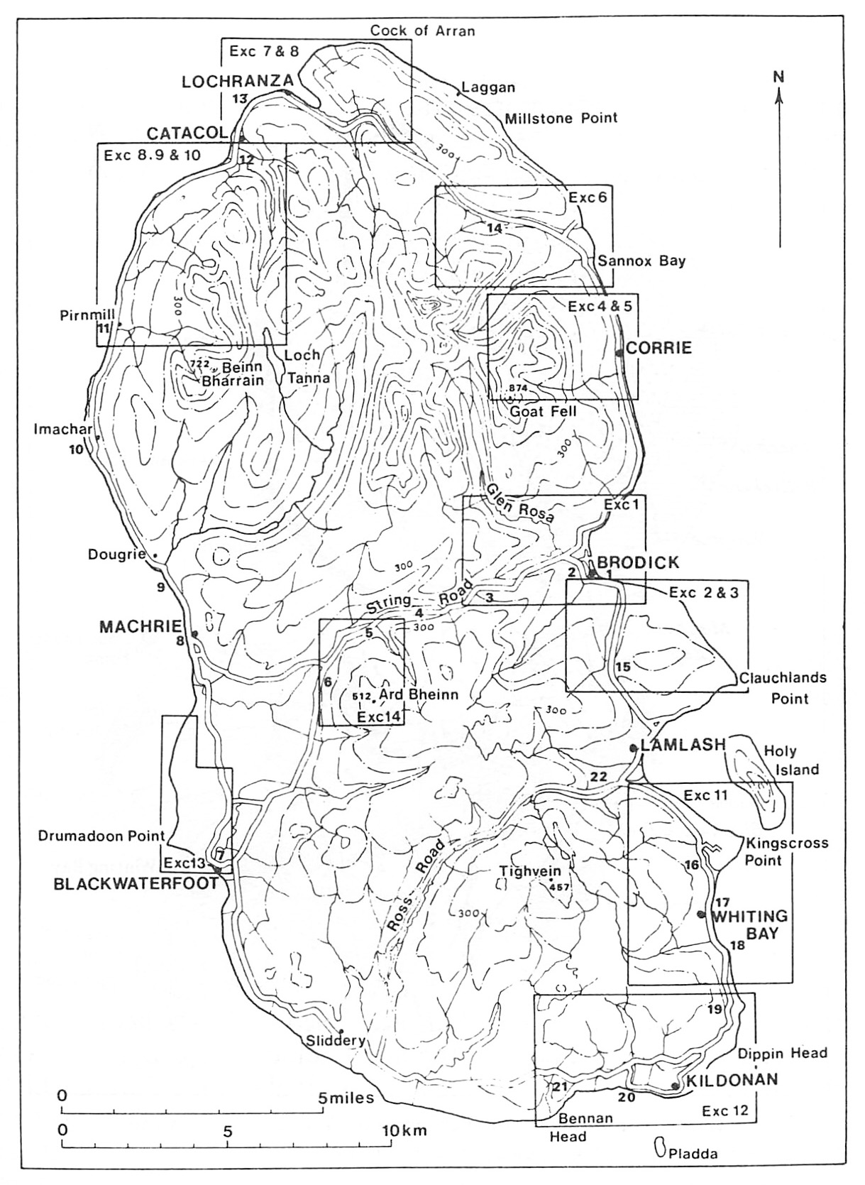
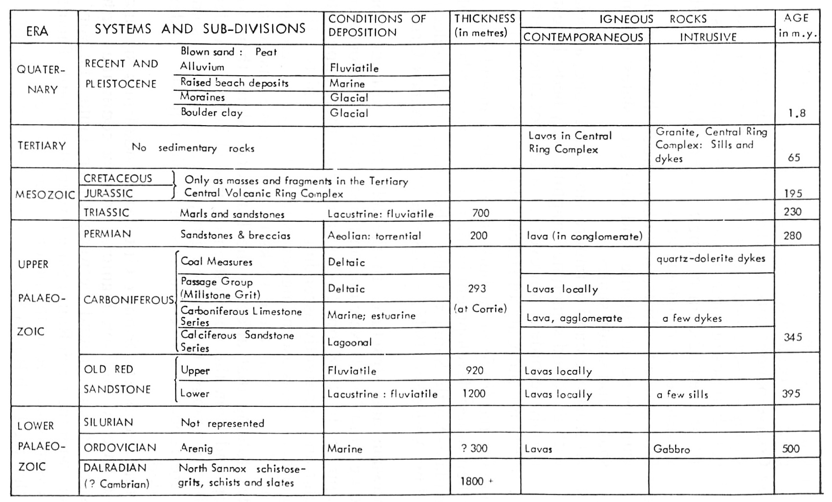
The wide range of geological systems and rock formations represented in Arran is shown in the table on page 21
1. Dalradian (Excursions 7 to 10 mainly)
The rocks grouped under this name are the oldest in Arran. They form part of a broad belt of metamorphic rocks of diverse types, which stretches across Scotland from Kintyre to the Aberdeenshire coast. The name Dalradian was given to them by Sir A. Geikie in 1891. In Arran they are confined to the northern part of the island where they form a ring round the Northern Granite, interrupted only along a distance of some five km on its eastern margin. The maximum width of the ring is about three km. Rock types present include:
- Quartzose schistose grits, varying in texture and composition: originally coarse-grained sandstones.
- Coarse pebbly grits, quartzose and feldspathic, often in strong massive beds up to about 2m in thickness; the pebbly bases of some of these carry quartz pebbles up to 10 or even 12.5 cm in length; originally impure pebbly sandstones or conglomerates.
- Fine-grained schists, including greenish-grey phyllites with abundant chlorite, and dark grey slates: originally shales and sandy shales.
- At least one band of impure sandy limestone, associated with dark and sometimes graphitic slaty beds; limestone is only recorded, however, at a few localities between Pirnmill and Catacol (Excursion 10, localities 20–21).
Group (a) and (b) form the bulk of the Dalradian and since they reach their fullest development in the hilly ground northeast of the Chalmadale–North Sannox valley they have been collectively termed by Anderson (1945, p. 268) the North Sannox Grits.
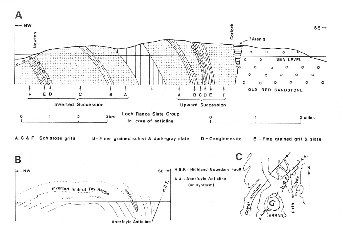
Succession and structure. In the hilly tract just mentioned, extending from North Newton southeastwards to Corloch, Gunn (1903, pp. 15–16; 1928, pp. 21–22) stated that "there appears to be a regular and apparently ascending series in the schists". He also distinguished in this ascending series ten different sub-groups but it is now known that these rocks in Arran have shared in the complex folding that affected the Dalradian along their whole outcrop and from the observation of graded bedding Anderson was able to establish that the ten groups were in fact six, some of which are repeated across the axis of a fold
- that the North Sannox Grits, subdivided into six distinct groups, lettered A—F on
(Figure 4) , form a continuous upward succession in the ground between Creag Ghlas Laggan and Corloch, with the Loch Ranza Slate Group at the base. Their total thickness may well be of the order of 1,980 metres. - that the Loch Ranza Slate Group occupies the core of a fold in which both limbs dip steeply to the southeast — the Loch Ranza Anticline (it is actually a synform or inverted anticline).
- that along the overturned northwestern limb of the anticline the sub-groups of the North Sannox Grits are repeated in inverse order. Here there are many examples of successive grit bands, varying individually in thickness from 0.6 to 1.8 metres, in which the graded bedding indicates inversion.
The structure shown in
In Arran two cleavages (schistosities) are associated with the Tay Nappe and relate to fold episodes. The earlier is associated with highly compressed folds with attenuated limbs and is strongly penetrative. The later is often expressed as a flaggy "fracture" cleavage (or strain slip cleavage) and is associated with folds which are seen most clearly where they form bands of fold hinges along which quartz has been thickened, the limbs being thinned out in the more micaceous lithologies. In the slaty members the two cleavages are coincident but in the quartzitic (psammitic) material the two are at angles of 10 to 20 degrees or so and give the rocks a lenticular appearance.
To the west in Arran a third phase of folding is seen. It can be correlated with the Cowal Anticline, on the mainland to the northeast. The style of folding is concentric and very complex but the earlier fold structures, cleavages and fold hinges, are still clearly discernible.
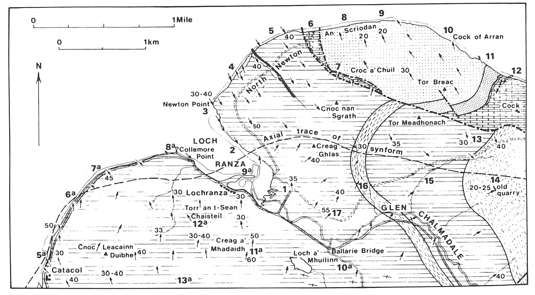
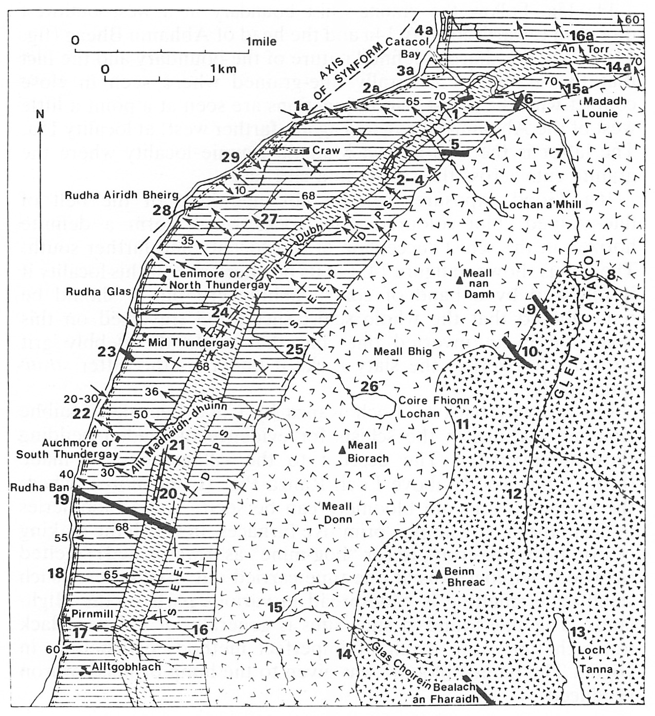
Catacol Synform. This structural feature, termed a synform rather than a syncline since it affects previously folded schists, was first described by Gunn (1903, p. 15). It results from the doming of the Dalradian schists by intrusion of the Northern Granite in Tertiary times. Along the eastern margin of the granite the southeasterly dip of the schists is steepened, but along the western and northwestern margin the rocks are tilted upwards and thrown into a pronounced synclinal fold, the axis of which crosses the coast at several points in the neighbourhood of Catacol (see
Age of the Dalradian. The Dalradian rocks in the vicinity of the Highland Border are, at least in part, of
2. Ordovician
The rocks that have been included here are confined to a narrow outcrop which crosses the North Sannox Water a little below the Sannox–Loch Ranza road bridge. The outcrop in the stream is about 300 metres in width and it extends up the hillsides to north and south over a total distance of about 2.8 km (Excursion 6, localities 6, 14, 15, 16). Gunn (1903, p. 18; Tyrrell 1928, p. 23) described the assemblage of rocks here as "an essential part of the metamorphic series" but from their general lithological resemblance to the
Anderson (1947, p. 512) ascribed the metamorphism of Dalra-dian and
There is no evidence anywhere in the Midland Valley region of a transition from Dalradian (
3. Old Red Sandstone
The Old Red Sandstone, largely owing to the pioneer researches of Hugh Miller (1802–1856), occupies a special place in the annals of Scottish geology. It is noted for its immense thickness, its prevailing red colour and its abundance of massive conglomerates; it is famous also for its fish-beds with their sometimes prolific remains of primitive types of fish and for the evidence it has yielded locally for true land plants, the forerunners of the rich and varied
3a. Lower Old Red Sandstone (Excursions 1 and 6 mainly)
With the close of Lower Palaeozoic times a new chapter in the geological record opens. As a result of powerful crustal disturbances known collectively as the Caledonian Orogeny, an entirely new topography had been produced. Scotland became part of an extensive land mass with lofty mountain ranges and broad stretches of intervening lowlands. One of the latter lay along the site of what is now the Midland Valley and it was in this that the Lower Old Red Sandstone sediments and their locally interbedded volcanic rocks slowly accumulated. Where most fully developed their total thickness is estimated to be as much as 5,800 metres. The sediments themselves, sandstones, mudstones and conglomerates, represent widespread flood-plain materials, derived by degredation of the high ground to the north (metamorphic Dalradian) and to the south (closely folded
The Lower Old Red Sandstone of Arran has an outcrop stretching from near Corloch southwards across North Glen Sannox and Glen Sannox to Glen Rosa and Shurig, thence turning westwards and sweeping across the centre of the island by An Tunna (361m) and Garbh Thorr (299m) to Auchencar and the coast south of Dougrie. Along its concave inner margin it is nearly everywhere in contact with Dalradian schists. The boundary line between Corloch and the granite margin near Cnocan Donna may be a continuation of the Highland Boundary Fault which crosses Bute from Rothesay to Scalpsie Bay and if projected to the SW comes to shore in Arran near Corloch; however, if it is the Highland Boundary Fault it does not express itself as clearly as it does on Bute or the mainland to the northeast.
From Cnocan Donna to a little south of the Corrie Burn the Lower Old Red Sandstone is in faulted contact with the Northern Granite along a markedly curved line interpreted by Bailey (1926) as originating with the emplacement of the granite. Along this line at various places there is evidence of crushing and mylonitisation, notably in the Corrie Burn (Excursion 5). It should be noted that to the west of Corrie a narrow strip of Dalradian rocks borders the granite for a distance of about 800m (Excursion 5, locality 11a). South of the Corrie Burn contact and along the rest of the outcrop the boundary between the Lower Old Red Sandstone and the Dalradian has been taken as a continuation of the Highland Boundary Fault and is shown as such on geological maps of the island. Gunn himself, however, in his characteristic cautious way expresses doubts on this point (1903, pp. 128–129). In papers dealing in detail with the Old Red Sandstone and the Highland Boundary Fault in Arran (Friend, Harland and Hudson 1964; Friend, Harland and Smith 1970) the Old Red Sandstone–Dalradian boundary has been reinterpreted as a step-faulted unconformity and red-stained Dalradian has been traced around the northern part of the island.
The rock types represented are; conglomerates with generally rounded boulders of quartzite and vein quartz; reddish feldspathic pebbly grits; and purplish to reddish thin-bedded sandstones and siltstones. The total thickness of the formation may reach about 1,200m. Broad local sequences may be established in different parts of the island, but correlation from one district to another is difficult because of intraformational discordances, local folding and lateral variations in thickness and facies. Good sections of the various sedimentary types can be studied in Glen Shurig and the Allt an Bhrighide (Excursion 1, localities 14 to 18), in Glen Sannox (Excursion 6, localities 1 to 5) and along the coast south of Dougrie. Some of the conglomerates contain numerous boulders of andesi-tic lava, while the associated sandstones carry grains of igneous material showing tiny feldspar laths (Excursion 1, locality 16 and Excursion 6, locality 3).
A useful marker horizon on the western side of the island is the interbedded volcanic series, about 25 to 30 m thick, which extends for about 4km between Auchencar and the northwest side of Garbh Thorr. Both hornblende-andesites and olivine-andesites are present. The former are specially abundant in the conglomerates referred to and their occurrence at different localities would suggest that the volcanic series had originally a wider extension.
Along the southern margin of the Central Ring Complex sporadic exposures of strata referred to the Lower Old Red Sandstone appear in the upper part of Clauchan Glen and at the heads of Benlister Glen and Glen Dubh. At these localities the beds have been indurated and altered by the intrusive masses of the complex. The original red and purple colours of the grits and mudstones have been changed to bluish and greenish-blue tints, while the bedding and other structural features have been largely obliterated.
The semicircular outcrop of the Lower Old Red Sandstone in conformity with the eastern margin of the Northern Granite has already been mentioned. Along the outcrop the dips, generally steep, swing round from NNE, in the northern part to SSE, or even S, in the southern part. This structure, in which the Upper Old Red Sandstone, the
3b. Upper Old Red Sandstone
During the interval that followed the close of Lower Old Red Sandstone times and preceded the deposition of the Upper Division further crustal movements occurred. The Lower Old Red Sandstone rocks were folded and faulted and then subjected to prolonged denudation. In some areas, indeed, they were completely removed.
In Arran the outcrop of the Upper Old Red Sandstone follows the same circular course round the eastern and northeastern margins of the granite as that of the Lower Division. Along this tract there is no clear structural evidence of any unconformity between the two. In the north of Glen Sannox, however, there is at one point (Excursion 6, localities 18–19) indications of an angular break along which the Upper Old Red Sandstone appears to overstep different members of the Lower. On the northwestern side of the Boundary Fault near Corloch there is a small outcrop of Upper Old Red Sandstone sediments, about 50m thick, resting on Dalradian schists and followed upwards by
In the northeastern exposures a rough three-fold division of Upper Old Red Sandstone is present. The lowest part of the succession consists of about 430m of thin-bedded reddish or purplish sandstones and massive bands of conglomerate with cobbles and boulders of vein quartz (mainly), quartzite and quartzose schists. Gunn has noted that the quartz fragments give a decidedly pale colour to the conglomerates although the matrix of sand is reddish. Above this a series of red sandstones passes upwards into an alternating conglomerate/sandstone succession, about 490m thick, best exposed along the coast at Sannox Bay. The highest beds in the succession contain irregular, often nodular bands of cornstone and they were formerly taken as forming the basal beds of the
Lying between the lower sandstones and conglomerates and the red sandstones mentioned above there is a thin development of basaltic lavas with a maximum thickness of perhaps 30m. The greatest part of the outcrops of these lavas, as mapped by Gunn, are now covered by afforestation and dense undergrowth. Such material as has been collected recently is, as previously described (Tyrrell 1928, p. 43), purplish-red, amygdaloidal and decomposed.
4. Carboniferous (Excursions 4 and 5 mainly)
The
- The northeast coast from near the Cock of Arran to near the Fallen Rocks; a strip about five km long and about 0.5 km in width; generally referred to as the Laggan section.
- The east coast at Corrie, a narrow strip about 1.2 km long (Excursion 4).
- The Locherim Burn and adjacent streams at High Corrie (Excursion 5).
- Sections in the Uisge nan Fear, about 400m south of the Corrie Burn (Calciferous Sandstone Series) and at the old quarry in the
Corrie Limestone at An Scriob north of Maol Donn. - The Merkland Burn and other localities north of Brodick Castle.
- Hillside south of the String Road, Glen Shurig (Excursion 1, localities 19 to 22).
There is also a narrow fault-bounded strip of
In the southern part of the island rocks of
Subdivisions and rock-types: The major subdivisions of the
The figures of thickness of the Coal Measures are after Leitch (1942); the others are derived from Gunn (1903, p. 46) but his estimates for the Lower Sedimentary Group include basal beds with nodular cornstones now placed in the Upper Old Red Sandstone. In the detailed account of the Corrie shore section on pp. 103 to 111 the writer has suggested slightly different thicknesses for some of the groups. The Passage Group of the Midland Valley
The rock types represented in the
Calciferous Sandstone Series. Both sedimentary groups attain their fullest development on the northeast coast. The rock-types include sandstones and grits, sometimes pale-grey, sometimes mottled with reddish patches, variegated mudstones, and thin bands of a grey muddy cementstone more common in the strata underlying the lavas. The volcanic group consists in the main of olivine-basalt lavas containing phenocrysts of olivine and augite (Craiglockhart type) or microphenocrysts of olivine and occasionally labradorite and augite (Dalmeny type). For a full account of the classification of the olivine-basalts of
Passage Group. The beds described by Gunn as Coal Measures are now known to include, in some localities, rocks referable to the Passage Group (formerly referred to as "Millstone Grit"). In the Merkland Burn, about 1.2 km north of Brodick Castle, red mudstone and marls, 22m thick and with an ironstone containing mussels at the top, closely overlie beds which include at the base a clay of bauxitic type, resting upon decomposed red ash and lava. These volcanic rocks and the overlying bauxitic clays are correlated with the Passage Group Lavas and Bauxitic Clay of north Ayrshire. Leitch (1942, p. 145) has recorded the occurrence of bauxite-like clays associated with volcanic ash in the Benlister Burn 4 km west of Lamlash. He has also suggested that the volcanic rocks occurring below red shales containing mussels in one of the head streams of the Sliddery Water on the south side of the Ross Road may be of Passage Group age. It may be noted that in the Machrihanish coalfield the Passage Group consists of a succession of lava flows, with some sedimentary intercalations, about 148 m thick. No volcanic rocks are present at this horizon at Corrie or at Laggan, although the occurrence of sedimentary rocks of Passage Group age cannot be excluded.
Coal Measures. The type of sedimentation characteristic of the Coal Measures of Arran can be studied on the Corrie shore (Excursion 4, locality 11) and at the northwest end of the Laggan section (Excursion 7, localities 11 and 12). Details of the section at Corrie, as worked out by Leitch, are given on page 110; the same author has also given a detailed description of the same beds at Laggan (1942, p. 149). Disturbed and contorted bedding is a common feature in the sandy beds, especially at Laggan. Variegated rooty seat-earths occur, sometimes overlain by reddish shales, but there are no traces of coal. Nevertheless the mussels Obtained at various localities have been sufficient to indicate their position in the non-marine lamellibranch succession established for the mainland. Leitch's tentative conclusions are set out diagrammatically below. (Tavle 4).
Each of these faunal zones in the mainland succession includes valuable coals. The diagram above suggests, as Leitch pointed out, that between the Passage Group volcanic rocks and the lower similis-pulchra zone of the two southern localities there is an unconformity cutting out the communis and modiolaris zones, while in the Merkland Burn and at Sliddery Water head, the sediments yielding similis-pulchra forms underlie gritty sandstones and lavas both placed by Leitch in the
5. New Red Sandstone
The sedimentary rocks that overlie the
The
Doubt as to the
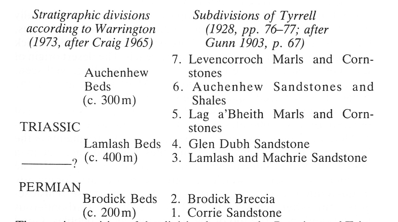
The stratigraphical divisions within the New Red Sandstone of Arran were originally made on a purely lithological basis by comparison with the
Craig (1965, pp. 387–388) emphasised the variability of the nature of the deposits within the succession and the considerable interlensing of strata that makes it difficult to correlate beds over quite short distances and suggested a simple three-fold division of the New Red Sandstone of Arran without attempting to place the position of the
The precise position of the division between the
5a. Permian (Brodick Beds) (Excursions 1, 2 and 13 mainly)
The rocks included in this system appear at the surface along a coastal strip of varying width between Corrie and Brodick. South of Brodick they continue along the coast towards Clauchlands Point but by the time Lamlash Bay is reached the rocks form part of the
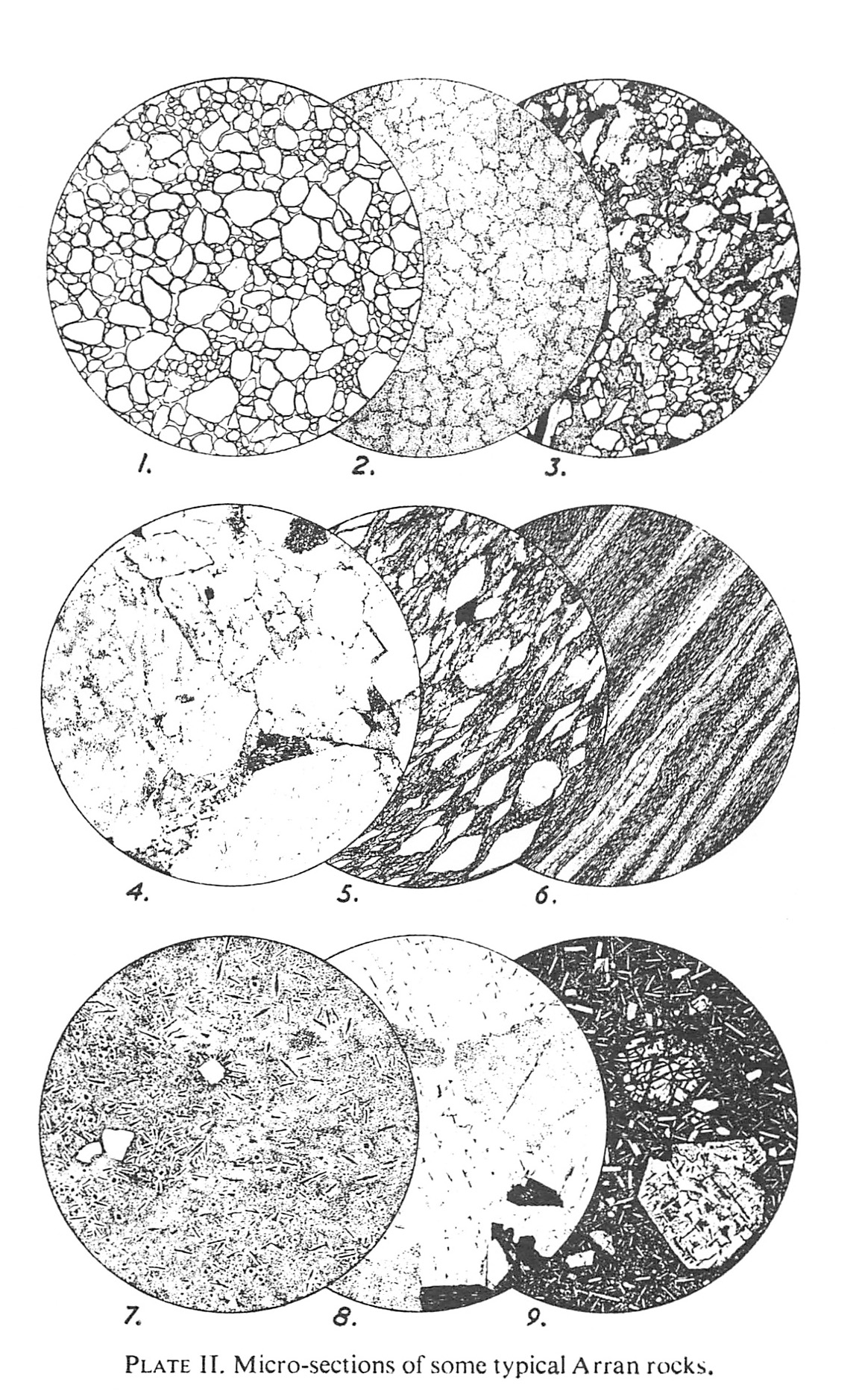
Corrie Sandstone . This group of beds, consisting essentially of a thick series of brick-red, markedly false-bedded sandstones, can be best examined along the shore between Corrie and Brodick and in the old quarries above the raised beach. The desert origin of the beds is shown by the characteristic dune-bedding, well seen, for example, on the north shoulder of Maol Donn, and by the rounded "millet seed" quartz grains(Plate 2) ,(Figure 1) .- Brodick Breccias. These beds are made up of a succession of breccias or conglomerates associated with massive, red, dune-bedded sandstones of
Corrie Sandstone type. The fragments in the breccias, sometimes angular, sometimes rounded, are set in a matrix of wind-rounded and wind-polished sand grains. The fragments themselves, which vary greatly in size, are dominantly of quartzitic rocks — vein quartz, quartzites, quartzose schistose-grits — but other types occur such as basalts ofCarboniferous affinites and, near the top of the succession, agate pebbles. Good exposures of the Brodick Breccias occur along the coast south of Brodick, in the central part of the Benlister Burn, in Glen Dubh and at the Cock of Arran.
Correlation and Condition of Deposition. The
The evidence that the
The conditions under which the
5b. Trias (Excursions 12 and 13)
The
(1) Lamlash Beds. The lower part of this succession is composed mainly of thin-bedded, generally soft, medium-grained sandstones of a reddish or purplish colour. Interbedded with these occur occasional pebbly or conglomerate bands, while locally bands of red mudstone or sandy mudstone showing sun-cracked and ripple-marked surfaces are present. Good sections are available along the Clauchlands shore, at various localities between Lam-lash and Whiting Bay, in the Lag a'Bheith, in Monamore Glen and in the Machrie District. Some of the more massive sandstones have been locally quarried for building stone, for example at Lamlash.
The upper part of the succession, referred to by Tyrrell (1928, p. 77) as the Glen Dubh Sandstone, is formed by a series of massive, variegated and often calcareous sandstones. They are exposed on the southern slopes of Glen Dubh above its junction with Glen Ormidale, but probably the best sections are seen at Largybeg where the weathering out of the calcareous cement has given rise to an irregularly channelled and pitted appearance on the rock surfaces. Similar sandstones also occur in exposures on the west side of the island — in Ballymichael Glen and in the Machrie Water roughly 1.6km from its mouth.
(2) Auchenhew Beds. The Lamlash Beds are succeeded by a thick series of sedimentary rocks which in their lithological characters present a strong contrast to those lower in the New Red Sandstone of Arran. They include variegated, often green-spotted shales and marls, fine-grained sandstones mottled in grey and reddish tints and sometimes calcareous, together with frequent bands of pale-coloured, nodular impure limestone or cornstone. These beds were originally referred to the Trias on account of their general similarity to the Trias of the North of England. Their total thickness in Arran is of the order of 300m or more. It is considered by Warrington (1973, p. 114) that the Auchenhew Beds represent an almost complete sequence of the Middle and Upper Trias: this, by implication, would indicate a Lower Trias or Bunter Sandstone age for much or all of the Lamlash Beds.
The Auchenhew Beds form the country rocks over a large area in the southern part of Arran and many excellent shore and cliff exposures are available to the student along the coast from near Largybeg Point to a little north of Drumadoon Point. Good exposures can also be seen in many of the streams draining the central plateau, for example, in the northern headwaters of the Glenashdale Burn and in the Allt Mòr, the Levencorroch Burn and the Sliddery Water, all reaching the sea along the south coast.
Evidence for the depositional environment of these beds is present in the form of numerous ripple-marked surfaces seen on some of the sandy beds, the shrinkage cracks in the bands of mudstone, the presence in some of the marls of tiny rhomb-shaped crystals of calcite, and the occurrence of layers of nodular calcareous segregations or cornstones all suggesting deposition in sheets of shallow water subject to alternate flooding and desiccation. Deposition in a shallow water fluvial-lacustrine environment appears to be supported by the work of Pollard and Lovell (1976) who studied burrows and associated sediments on the west coast of Arran south of King's Cave but other work (Pollard and Steel 1978) recording halite pseudomorphs, symmetrical ripple marks and other sedimentary structures in the same area, suggests that at least part of the succession was deposited under intertidal conditions adjacent to an arid coast.
With the close of the
6. Mesozoic fragments in the Central Ring Complex
One of the most striking results of Gunn's survey of Arran was his discovery of masses of
7. Tertiary Period
The regional uplift that followed upon the close of
The duration of the Tertiary Period is estimated at approximately seventy million years. It comprises five geological epochs named from below upwards — Palaeocene,
The broad sequence of events in the story of the Tertiary Period in Arran may be briefly reviewed under the headings: (a) interval of early-Tertiary denudation; (b) interval of Tertiary igneous activity; and (c)interval of late-Tertiary denudation during which the main features of the present landscape were slowly evolved.
7a. Early Tertiary denudation
The emergence of a new continental land at the end of
7b. Tertiary igneous episode
Several criteria have been used as guides in attempting to define more precisely the age of the Tertiary igneous rocks. Plant remains obtained from sediments locally associated with the lavas in Mull, Skye, etc., have been regarded as comparable with the flora yielded by Lower Tertiary strata in Greenland and other Arctic regions. The West Highland succession has long been considered, accordingly, to be of early Tertiary age.
Only recently has reliable laboratory evidence begun to be available to set more precise limits to the age of Tertiary igneous activity in Arran. An Ar incremental heating date of 60.4 ± 0–6 million years (Evans et al 1973) agrees precisely with the Rb-Sr whole rock age of 60.3±1.6 million years (Dickin et al 1981) for the Northern Granite, while dates obtained by the former method for the Drumadoon sill, the Holy Island sill and a tholeiite dyke at Port na Feannaiche indicate a narrow range of dates from 58.3 to 56.3 million years (A. E. Mussett 1982, personal communication). A study of palaeomagnetic polarities (Dagley et al 1978; Hodgson 1981) supports the evidence that the igneous activity in Arran was confined to a rather brief episode during early Tertiary (late Palaeocene to early
Approximately 42% of the area of Arran is occupied by igneous rocks of Tertiary age. These represent a small portion of a volcanic province which at one time must have extended from northern Ireland and western Scotland over much of the continental margin to include St. Kilda and several submerged centres on the continental shelf. "This", in Geikiels words (1910 p. 20), "was the last, and perhaps the grandest, of all the volcanic scenes in the history of the British Isles." Of this old volcanic land only remnants now remain — in Antrim, the Inner Hebrides, Ardnamurchan and Arran.
The Tertiary igneous rocks of Arran fall into the following categories: (1) the numerous sills in the southern half of the island; (2) the Northern Granite; (3) the Central Ring Complex; and (4) the swarm of more or less vertical dykes. Elsewhere in the Tertiary volcanic districts of Scotland one of the earliest manifestations of igneous activity was the outpouring of flow after flow of lava to thicknesses of as much as 2,000m or more (Mull, Skye, etc.). In Arran there is no direct evidence for a corresponding extrusive phase although it is probably represented by the 2.4 km long ourcrop (or screen) of basic lavas occurring in the Central Ring Complex to the west of Ard Bheinn (see p. 50 and Excursion 14, locality 5).
(1) Sills of south Arran. There were several phases of sill intrusion during the Tertiary igneous activity in the island each with its own characteristic assemblage of rock types. The following broad categories have been recognised:
- A group represented by sheets of analcime-olivine-dolerite or gabbro, usually referred to in the literature as crinanite although the term is not strictly applicable. The main localities are the Clauchland Hills, Monamore Glen, Kingscross, Dippin, Columbkille and Auchareoch. The three first mentioned are arranged in a broken semicircle around Lamlash. Tomkeieff (1961, pp. 6–8 and fig. 3) put forward suggestions regarding the relationship of these and other intrusions to a hypothetical centre under Lamlash Bay. As a group they are notable for their transgressive relations to the sedimentary rocks in which they are emplaced; for the development of tachylitic, basaltic and doleritic types, often with complicated mutual relationships in their margins and against included masses of sedimentary rock; and for localised severe, pyrometamorphism of the country rocks. From their similarity in petrographic character to olivine basalt of Plateau type they have been regarded as the earliest of the intrusive rocks and to be of the same age as the basaltic lavas preserved in the Central Ring Complex. Although the members of this group have so far been regarded as of fairly uniform composition, it has been found that a thin layer of picrite forms part of the Monamore sheet. It is estimated that the thickness of the larger bodies may have reached 100m; in the case of the Dippin intrusion a thickness of 42.8m has been proved by drilling (Gibb and Henderson 1978b). A thorough description of the petrography of the latter intrusion (ibid.)accords the most complete investigation of a member of this group to date.
- A group represented by the sills of quartz-dolerite and associated felsic rock types so abundant in the south of Arran. They vary in thickness from under a metre to 80m. More or less concordant with the bedding of the country rocks they give rise to well-marked scarp and terrace topography (unfortunately now largely obscured by afforestation). A few transgressive dyke-like bodies occur. Many of the intrusions forming this group are composite, having relatively mafic interior components flanked by more felsic bodies. Occurrences of basaltic xenoliths in doleritic, granophyric or felsitic matrices are numerous. Unlike the analcime-bearing intrusions, they seldom carry xenoliths of country rock. Sills belonging to this group occur in Glen Ashdale (Excursion 11a) and cap many of the tabular hills to the west such as Auchenhew, the Levencorroch Hills and Cnoc Ballygown. Proof that this group is younger than group (a)is given in Excursion 12 (locality 3). The intrusions forming the Tighvein complex are co-magmatic with those of group (b), differing mainly in being more coarsely crystalline (Tyrrell 1928, pp. 133–135; Herriot 1975, pp. 7–11).
- A group of acid sills represented by the massive quartz-porphyry intrusions of Bennan Head (Excursion 12), Brown Head and Drumadoon (Excursion 13). Dun Dubh in the Corrygills district (Excursion 3, locality 5) is another large intrusion of the same type, probably plug-like in form. A quartz-porphyry dyke 3.35 m thick, occurring on the Corrygills shore east of Dun Fionn may perhaps be connected with it (Excursion 2, locality 14a). Sometimes the quartz-porphyries are associated with basic rocks, generally tholeiitic, in composite sills. Both the Bennan and Drumadoon intrusions have basic selvedges of this type. A notable feature of these marginal tholeiites is that they usually contain xenocrysts of quartz and orthoclase.
In addition to the generally massive sills listed above there is a group of minor acid intrusions which include the pitchstones and associated felsites for which Arran has long been famous. They may occur as separate intrusions, as composite felsite-pitchstone sills or dykes, or as composite dykes of pitchstone and tholeiite. While many of the intrusions included in this group are sill-like in form and concordant with the bedding of the country rocks, others are dyke-like and transgressive. Sometimes, again, individual intrusions change in form from a sill to a dyke. The pitchstones vary in colour from greenish to almost black and have a resinous lustre. On closer examination they show a glassy base more or less crowded with crystallites which build up the fern-like growths present in many types (Plate II, fig. 7). Tilley (1957) has identified the dominant mineral in these growths as biotite. Some types of pitchstone carry porphyritic crystals of quartz, feldspar (both with inclusions of glass), augite or olivine, the nature of the phenocrysts varying with the rock type.
A number of intrusions of pitchstone or of composite pitchstone-felsite have been chosen for examination during the excursions. Notable examples are the sills on the Corrygills shore (Excursion 2, localities 1 la and 15a); at South Corrygills (Excursion 3, localities 2 and 3); in the Lag a'Bheith burn (Excursion 3, locality 12) and at West Shurig Farm (Excursion 1, locality 23). The well-known composite dykes on the Tormore shore north of Blackwaterfoot may also be included in this list (Excursion 13).
The age, or ages of the various intrusions which comprise this group have not been determined with any certainty. Although they would seem to be later than the members of groups (a) and (b), they nevertheless probably cover a wide time-range. Some can be referred to the period of intrusion of the quartz-dolerite sills (see Tyrrell 1928, pp. 137, 210), but others may belong to an early stage in the final phase of dyke injection (p. 51). Intrusions of pitchstone, of felsite or of composite pitchstone-felsite are known to cut the great crinanite sheets (Excursion 3, locality 6), the Northern Granite in many places (eg. Excursion 6, locality 8) and the granite of the Central Ring Complex. The felsite of Torr Righ Men- and Torr Righ Beag, north of Blackwaterfoot, appears to be later than the basic dykes of the dyke swarm, since the dykes cutting the country rocks round it do not transect the felsite itself. The same relationship holds in the case of the riebeckite-trachyte mass forming Holy Island (Excursion 11b).
(2) The Northern Granite. This granite mass, dome-shaped and nearly circular, covers an area of some 90 sq. km. It consists of an outer coarse-grained granite and an inner fine-grained variety, the latter intrusive into the former and giving rise to lower and less rugged ground. The minerals comprising both varieties are quartz and feldspar (mainly orthoclase) together with a varying but often meagre content of black mica (biotite). A plutonic intrusion of deap-seated origin, the granite's thick cover of Dalradian and younger rocks has long since been removed by the agencies of denudation. There are three types of contacts or junctions to be examined:
- The interior junctions of the two varieties of the granite itself. These have been described by Flett (1942) and opportunities for examining some of them are provided during Excursion 9.
- The intrusive contacts of the granite with the surrounding schists. These can be examined at a number of localities: Glen Rosa (Excursion 1, locality 13); in the Allt a'Chapuill (Excursion 5, locality 11a); in North Glen Sannox (Excursion 6, localities 10, 12 and 13); at Madadh Lounie on the east side of Catacol Glen (Excursion 8, locality 15a) and elsewhere.
- The faulted contact of the granite with the Lower Old Red Sandstone in the Corrie Burn (Excursion 5).
Evidence for the forceful nature of the intrusion of the Northern Granite can be seen on its western side where there has been uplift of the lower inverted limb of the Tay Nappe, in the north where the uplift is responsible for swings in the trends of the Dalradians, and along the southern margin where there has been considerable uplift and steepening of dips even in the
On a number of the excursions there are opportunities for examining the joint systems and mode of weathering of the granite massif. Druses or drusy cavities lined with crystals are not uncommon and occur in both the coarse and fine-grained types. These crystals are in the main the same as those of the enclosing rock, viz. quartz and feldspar. Occasionally, however, translucent crystals of quartz are present, tinted reddish-brown (cairngorm or smoky quartz) purplish (amethyst) or yellowish (Scotch topaz); blue beryl and topaz have also been recorded (Heddle 1901; McCallien 1937).
(3) The Central Ring Complex. (Excursions 14a and 14b) — This designation is given to the large oval-shaped volcanic centre lying south of the String Road where Gunn discovered broken masses of
The rocks forming the complex are igneous and pyroclastic. Amongst the former group are found intrusions of granite, granophyre, diorite and gabbro (relatively coarse-grained) and finer-grained felsite, porphyry, trachyte and dacite. Extrusive types also occur including andesites and basalts. The pyroclastic rocks are highly varied in texture and composition as they contain fragments of both sedimentary and igneous origin and include both agglomerates and tuffs. Brecciated andesitic and basaltic lavas also occur. Included in the agglomerates are blocks of
Inspection of the published maps shows arcuate patterns in the outcrops of the igneous and pyroclastic rocks. This general similarity of the Arran centre to the more perfect ring complexes of Mull and Ardnamurchan led Tyrrell (1928, p. 165) to replace Gunn's earlier name of "volcanic vent" by "central ring complex".
For further details of this interesting area the reader is referred to Tyrrell (1928), King (1954, 1955) and Ashford (1958). The median area, from Cnoc Dubh by a'Chruach and upper Glen Craigag to Beinn Bhreac has not received detailed examination.
(4) The Arran dykes. The dykes, by reason of their abundance and their variety in character, are among the most remarkable features in the geology of the island. Collectively they are known as the Arran Dyke Swarm. Here, as in the case of the sills, age relationships are often very uncertain. Some of the larger dykes of analcime-olivine-dolerite no doubt belong to the period of intrusion of the great sheets of the same composition (p. 46). Other dykes, again, may be assigned on petrographic evidence to the time of intrusion of the quartz-dolerite sills (p. 47), or to that of the quartz-porphyry group (p. 47). But the great majority of Arran dykes, mainly basaltic in character, cannot be assigned to any particular stage in the development of the igneous activity. It appears likely that they span three magnetic polarity periods lasting over three million years (Dagley, Mussett, Wilson and Hall 1978; Hodgsen 1981) with the majority being reversely magnetised.
In thickness the Arran dykes vary from about 0.3 m to 30 m though in the case of one or two composite intrusions the thickness may reach about 60m. The general direction is NNW or NW. In order to accommodate the amount of igneous material represented by the swarm of dykes, considerable stretching of the earth's crust has taken place. Tyrrell (1928, p. 249) has shown that in Arran over a belt of country 23.8 km . wide, containing 525 measured dykes with a combined thickness of 1,650m the stretching of the earth's crust in an ENE direction, i.e. perpendicular to the most common dyke direction, is 1 km in 14.4 km.
7c. Later Tertiary denudation
At the close of the volcanic episode the land area of the western margin of Scotland was probably much more extensive than it is today with much of what is now continental shelf above sea level. The youngest rocks exposed at the surface were the immense piles of lava (plateau basalts) punctuated at intervals by major central volcanoes the deeply eroded remains of which are now seen in the intrusive complexes of St. Kilda, Skye, Rum, Mull, Ardnamurchan, Arran, and the now totally submerged centre at Blackstones Bank, to the west of Islay. This land surface possibly extended to the south to link up with the basalt plateaux of Antrim in the north of Ireland. The rest of Scotland was probably an undulating tableland floored largely by remnants of
The stages by which this process of denudation was accomplished must be largely a matter for conjecture. It may be inferred that there were periodic earth movements producing a succession of topographies and setting in train successive fresh cycles of erosion. There was certainly at one period a series of powerful crustal disturbances which locally folded the lavas and underlying rocks and renewed movement along some of the old NE–SW lines of fracture. George (1960, pp. 98–99) has drawn attention to the striking effects of these earth movements in Antrim and has referred them to a mid-Tertiary "Alpine" period of deformation. The suggestion may also be hazarded that tensional stresses in the earth's crust related to the early opening of the northern part of the North Atlantic may have contributed to the breaking up of the western volcanic land as the result of differential or block subsidences which in places carried the Tertiary lavas and underlying
The geomorphology of Arran has been described by a number of writers, notably Smith (1896), Gunn (1903), Mort (1911, 1914), Scott (1918), Gregory (1920) and Tyrrell (1928). Tyrrell's account, which closely follows the views of Gregory, includes a sequence of events that can be summarised as follows:
- Production of an elevated undulating plateau surface, 600m to 900m above sea level:
- Development of consequent rivers:
- Uplift, with development of tectonic valleys to east and west isolating Arran from the mainland:
- Prolonged denudation, with the formation of a low plain of marine erosion.
- Uplift with the formation of the 300 m Platform:
- Prolonged denudation, with enlargement of the valleys to east and west.
The validity of the above sequence depends very much on how the physiographic features of the island are interpreted, in particular the nature of the valleys and the recognition of platforms.
1. Platforms. As already mentioned (p. 17) the 300m (1,000 foot) Platform is a striking feature in the landscape. It forms a part of the Intermediate Platform of Peach and Home (1930, p. 2), a feature widely represented in the Scottish mountains. It makes a well defined shelf round the Northern Granite, with a maximum width of about 800m, and slopes gently upwards to the granite mountains. Its height varies from a little below to a little above 300m. Following the views of Tyrrell and his predecessors George (1966) emphasised the view that this, along with other erosion surfaces which he recognised in the Hebrides, was the result of marine abrasion but the great width of the 300m surface places some difficulty on this interpretation.
There is evidence that Scotland was experiencing a subtropical climate during the late Tertiary era. In areas of the world where such conditions prevail at the present day one of the dominant land forms is the wide plain of subaerial erosion, often associated with the steep-sided mountains known as inselbergs. It requires little imagination to visualise the northern peaks of Arran as inselbergs rising above an erosion surface the remains of which are preserved as the 300m platform.
2. Valleys. The through-valley which cuts across the island from Loch Ranza to Sannox is regarded as a relic of the early consequent drainage. This depression now holds the northwest flowing Chalmadale and the southeast flowing North Sannox Water, with a watershed at about the 200m level. Scott (1918, p. 93) suggested "that the depression following the line of Glen Rosa and passing west of the Clauchland Hills to the channel between Holy Island and Kingscross may have also been part of the consequent drainage". Of the three major valleys cutting across the granite from north to south the same writer, following a suggestion made by Smith, regarded Glen Iorsa and Glen Rosa as perhaps developed along "synclinal" axes on the undulating surface of the granite, while the Glen Catacol–Glen Scaftigill depression lies along a shatter-belt. In the northern part of the island the minor streams are in the main radial to the granite mass and some have cut gorges in the 300m Platform. In southern Arran the drainage pattern would appear to depend more closely upon geological structure. Some of the streams, like the Kilmory and Sliddery Waters follow the dip slope of the New Red Sandstone in a southwesterly direction; the courses of the others, such as Glen Craigag and the upper part of Glen Ashdale have been guided by northwest–southeast dykes; others again are radial to the dome-shaped area of the Central Ring Complex.
The Arran valleys show many of the features characteristic of glacial action — steepened walls, flat floors, truncated spurs, etc. According to Scott and Gregory, however, there is little evidence of overdeepening, indeed this concept is coming into increasing disfavour as knowledge of the mechanisms of glacial erosion increases (see Price 1973, p. 53). It seems more likely that lateral widening of the trunk valley produces hanging valleys.
Differences of opinion have been expressed as regards the origin of the deep valleys to the west and east of Arran, which isolate it from the mainland. Scott suggested that they originated as parts of the consequent drainage. He pointed out that one of the consequent rivers may have continued from lower Loch Fyne along what is now the Sound of Bute, while another developed along the North Channel. "It seems feasible", he added, "that part of the Firth of Clyde, at least, is due to tributaries of the latter cutting back and capturing the head waters of the more northerly stream. Kilbrannan Sound may be accounted for in this way." Gregory, however, assigned these valleys to tectonic movements (which he also regarded as having been responsible for the origin of the north—south valleys in the Northern Granite). "The general course of the eastern and western coasts has been determined by faults and fractures. Kilbrannan Sound to the west and the main Firth of Clyde to the east are probably both sunken blocks, which have been let down by north and south trough-faults; and the block of North Arran was doubtless rent by north and south clefts."
While Gregory's views on the valleys in the Northern Granite may not be fully acceptable his suggestions regarding the origin of the Arran coastlines have been vindicated, at least in part, by marine geophysical surveys carried out in the Firth of Clyde (McLean and Deegan 1978, fig. 8.1) which have revealed major faults parallel to the north and eastern coastlines of Arran, and deep sedimentary basins around most of the island. There can be little doubt, however, that the final shaping of the outlines of the island have to be attributed to the erosive events of the
8. Quaternary Period
The broad divisions of the
8a. Time of widespread ice-sheets
This interval, often referred to as the time of maximum glaciation, began about two million years ago with the onset of arctic conditions increasing in severity until almost the whole of Scotland was covered by a mantle of slowly moving ice reaching thicknesses of hundreds of metres. It is with the effects of glaciation on a land surface of varied relief that we now have to deal. Its effects are strikingly displayed in the abraded, scoured and striated surfaces over which the ice, with its embedded rock fragments has passed and in the vast quantities of debris torn from rock surfaces on its passage and carried forward to be finally deposited as ground moraine.
Detailed studies of these effects have shown that they cannot be ascribed to one widespread advance and retreat of the ice. It is clear that one general glaciation cannot account for the diversity of direction of ice-flow. Successive major trends of ice movement on a regional scale have been recognised in Caithness, in Aberdeenshire, in Kincardineshire, and in the Midland Valley, where they have left behind them successive deposits of boulder clay differing in character and content and sometimes separated by bands of stratified sands and gravels. The cause of these successive major ice flows must be looked for in the variations in pressure exerted at different times by Scandinavian ice off the east coast and by ice radiating from the Highlands and Southern Uplands.
Sometimes the deposits left behind by an ice sheet show that for part of its course it has travelled over the sea bed. Thus, the ground moraine of an early ice sheet crossing Aberdeenshire and Kincardineshire from the northwest brought with it Arctic marine shells dredged from the Moray Firth. Another ice flow moving from the West Highlands down the Firth of Clyde was deflected eastwards, perhaps by Irish Sea ice, and carried inland over central Ayrshire clays containing Arctic shells such as
8b. Lateglacial Interval or Time of Retreat
In the closing stages of Glacial times all the conditions that marked its beginning took place in reverse order. The great ice-sheet gradually dwindled and broke up, giving way to a confluent glacier stage and then to a valley glacier stage, finally disappearing as the climate grew milder and milder. The retreat was also accompanied by changes in sea level of which a brief account is given later.
1. Confluent Glacier Stage. This may be said to mark the first stage in the dissolution of the ice. There was still a general covering of ice over the country fed by glaciers radiating from a number of centres of dispersion. Many of the effects of erosion and sculpturing by ice must be set down to this stage. At this time ice was probably moving slowly southwards from the Argyllshire highlands down Kilbrannan Sound and the Firth of Clyde, sweeping across Arran where the Goatfell massif stood up as a nunatak dividing the flow into two streams.
The vast quantity of broken and ground-up rock fragments embedded in the lower layers of the ice were deposited during its retreat and left behind as an irregular hummocky mantle of rock debris in a clayey or sandy matrix. Examples of this type of deposit, generally known as boulder clay, can be well seen in some of the streams in south Arran, e.g. in Glen Ashdale, in the Sliddery Water, etc. where its usually reddish sandy character shows that it is in a large measure of local origin and derived from the New Red Sandstone of the district. Much of the lower moorland country in Arran has a cover of stony ground-moraine material with a hummocky and occasionally drumlin type of topography, often referred to under the general term of morainic drift.
2. Valley Glacier Stage. In the course of time the ice was more and more confined to the major valleys. The glaciers occupying these valleys were still powerful agents of erosion, continuing the process of sculpturing their profiles. They also left striking examples of ice-borne materials in the form of lateral and terminal moraines marking stages in their retreat. There are many good examples of moraines in Arran: for instance, in Glen Rosa and Coire a'Bhradain (Excursion 1, localities 10 and 13); in Coire Lan at the head of the "White Water"; in Coire nan Larach (Excursion 5, locality 9a); at the head of Glen Sannox and elsewhere. In Glen Dubh at the head of Glen Cloy there is a series of concentric moraines fronting an alluvial flat which must at one time have held a small temporary glacial loch. Sometimes the moraines take the form of an irregular assemblage of small mounds.
3. Corrie Glacier Stage. Ice erosion at valley heads often led to the excavation of the amphitheatre-like hollows known as cirques or corries. These recesses, into which the ice finally shrank, were long occupied by small corrie glaciers representing the last phase of active ice. A good example in Arran is Coire Fhionn Lochan (Excursion 10, locality 26).
The corrie and valley glacier stages described above were probably repeated during the Zone III Loch Lomond Readvance (see Table on page 68; and Price 1982, p. 67), during which time ice was quite extensive in the northern granite hills of Arran.
4. Fluvio-glacial Deposits. Under this heading come deposits of gravel, sand and silt carried by melt-waters from the front of the receding ice. This drainage escaped in a number of temporary and shifting streams and the materials borne away by these were spread out irregularly to form what is known as an outwash fan. Much of the moundy deposits of sand and gravel in the lower valley of the Machrie Water and some of the spreads of gravelly debris flooring the valleys outside the moraines represent outwash material.
Other fluvio-glacial deposits were formed around (and sometimes over) bodies of dead or stagnant ice which had become cut off from the main body. There is a diversity of features of such types to be seen from the road between Shiskine and Glenloig Farm. These include kame terraces, kames and eskers.
5. Changes in sea level. The later stages of the
At the beginning of Glacial times sea level stood very considerably lower than it does today, probably by at least 90 or 120 metres. Towards the close, however, a slow submergence took place and the sea rose on the land in the wake of the retreating ice. It was during this phase that the terrace feature known as the High Lateglacial Raised Beach (formerly called the 100 foot Raised Beach) was formed. The inner margin of this terrace is seldom defined by any definite erosional features. Although it forms a well-marked terrace at many localities on the Scottish coast its actual height above present-day sea level varies somewhat from place to place.
Donner (1959, 1963) and Sissons (1963, 1966 and 1967) have shown that there is a series of Lateglacial shorelines in Scotland at altitudes varying from 40 to 12 metres. Each of these shorelines is tilted towards the Central Highlands, which was the main centre for ice dispersion in Scotland. As the ice was thickest in this area, the depression of the land under the weight of the ice was greater here than elsewhere and consequently it is in this area that the greatest amound of compensatory uplift has taken place. The result is that features produced at sea level when the ice melted may have now been lifted many metres above sea level, the amount of uplift varying with distance from the former ice-centre.
That the High Lateglacial Raised Beach was contemporaneous with the valley glaciers is shown by the fact that in many cases its deposits merge into or underlie valley glacier materials, while its absence in a number of the sea lochs along our western coast is ascribed to the presence of glaciers still active at that time. In Arran valley glaciers probably excluded the Lateglacial sea from all but the lower parts of Glen Rosa and Loch Ranza but in the southwestern part of the island where the lower Iorsa was a sea-loch the sea penetrated up the Machrie and Black Waters to flood a large part of the Shiskine plain. The coastal hill ridge which includes Torr Righ Beag (107m), Torr Righ Mòr (136m) and Drumadoon Fort (about 60m) must then have been isolated. The deposits of the Lateglacial sea, where exposed in Glen Rosa, in the Iorsa near Dougrie Lodge, and elsewhere, are all coastal sands and gravels. In the wider estuary of the Clyde, however, deposits of the same age include deeper water offshore clays containing marine shells of sub-arctic or arctic types. Following upon High Lateglacial Raised Beach times there was a gradual emergence of the land or retreat of the sea. That there were halts in this uplift is shown by the occurrence at various localities round the Scottish coasts of a beach feature at about 15 m, or sometimes a group of these at heights between 14 and 23 metres. There is evidence in some of the western sea-lochs that glacial activity had not ceased at the time of the formation of the 15 m terrace feature. The possible interpretation of the terraces at this level in some areas as fluvio-glacial outwash fans still leaves them within the Lateglacial period of retreat.
In Arran, Gunn (1903, p. 139; and in Tyrrell 1928, p. 265) has drawn attention to "the evidence of several beaches at different levels rising from 40 to 50 feet (12 or 15 metres) to over 100 feet (30 metres) above the sea, which are beautifully exhibited near the mouths of the Iorsa and Machrie streams". He also pointed out that these marine terraces "have evidently suffered much denudation by the action of the sea along the exposed part of the coast, and by streams at their mouths, and in the bays of Brodick and Lamlash, where several burns enter the sea".
Lateglacial times came to an end about 11,000 years ago. In the interval between it and the succeeding Postglacial epoch there was a marked amelioration in climatic conditions.
8c. Postglacial times
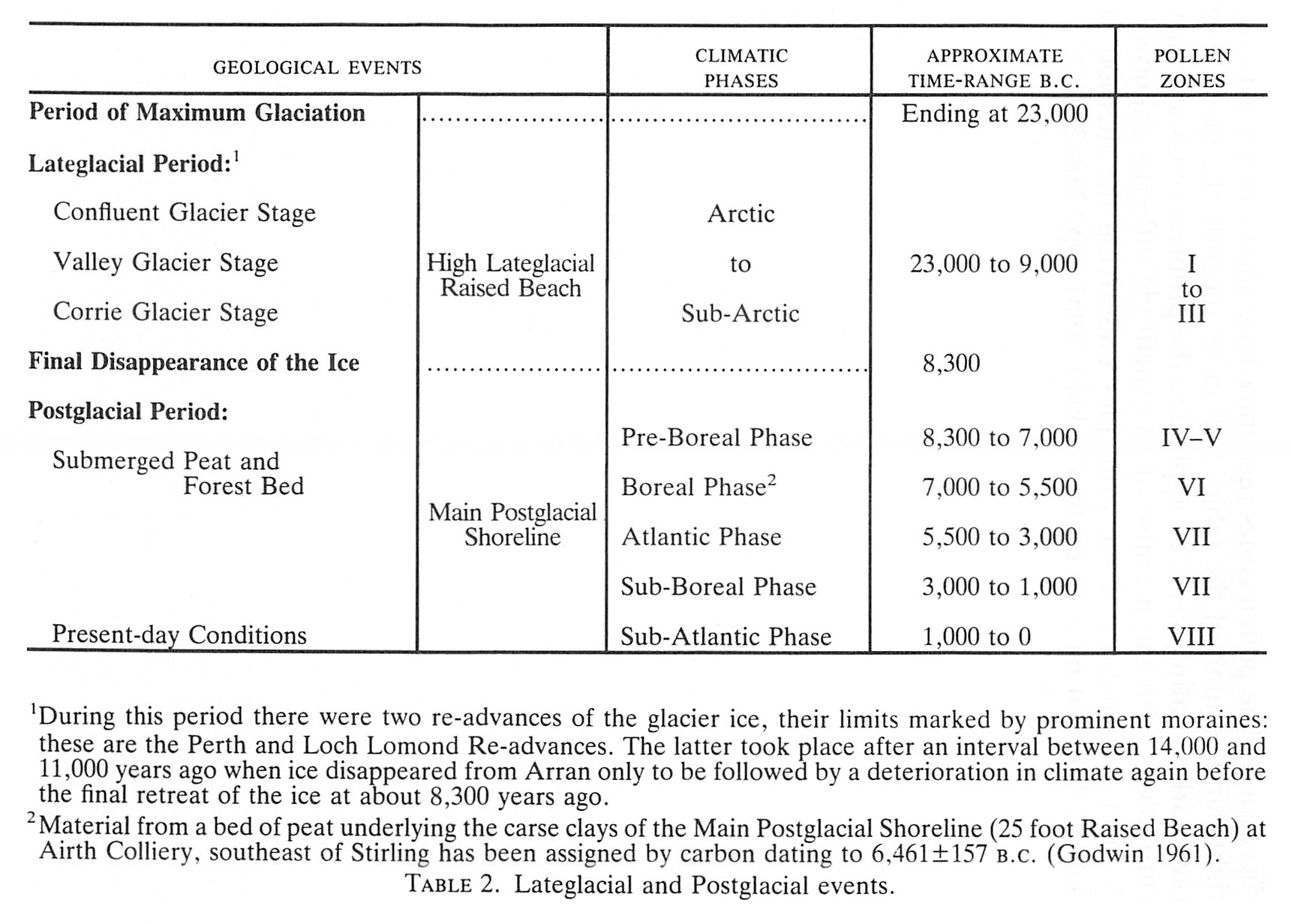
Under this heading are included the various geographic and climatic changes that followed upon the final disappearance of the ice. The former are briefly described on paragraphs (1) to (3) below, the climatic changes in paragraph (4). A tabulate statement showing the succession of events is given on page 68.
1. After the formation of the terrace feature at or about the 15 m level emergence of the land continued until sea level stood somewhat lower than it does today. The evidence for this lies in the occurrence of submerged peat-beds, remains of forest trees and old land surfaces at a number of widely spaced localities round our coasts. For example, in excavations and borings in the estuaries of the Clyde, Forth and Tay, a submerged peat-bed has frequently been recorded lying between the arctic clays of the High Lateglacial Raised Beach and the deposits of the later Main Postglacial Shoreline (formerly called the 25 Foot Raised Beach) or carse clays. The peat-bed contains nuts and pieces of bark of both hazel and birch. This stage represents a halt of sufficient duration to allow the growth of trees and, later, of their destruction by the invasion of peat mosses. It corresponds to the Boreal phase of the climatic succession.
2. Main Postglacial Shoreline. This marine terrace, formed during the submergence of the land which followed Boreal times, is a striking feature round many parts of the Scottish coast. Its wave-cut platform backed by cliffs with old. sea-caves, and often showing old stacks, distinguish it from any of the earlier beaches. It is well developed in Arran, notably between Brodick and Sannox, between Loch Ranza and Catacol and north of Druma-doon. Its deposits carry a littoral marine fauna similar to that of the present day. A good section of the shelly sandy clays of this beach was exposed during excavations at the site of the Post Office building in Brodick.
It may be noted here that the height of the shoreline varies slightly from place to place. In the Forth Estuary, for example, its inner margin rises gradually from a level of 7.5 metres at Bo'ness to about 14 metres near Stirling. Skeletons of seals and stranded whales have been recorded from the deposits of this beach. The period of its formation corresponds with the Atlantic phase of the climatic succession.
3. After the formation of the Main Postglacial Shoreline there followed a fall in sea level and the final establishment of present-day conditions. There is evidence in parts of the coastline of northern Scotland of a halt in this process and the formation of a terrace at the 4.5 metre level. There is also some evidence to suggest that the latest movement has been a slight submergence which may still be in progress (Callander 1929).
4. Climatic Changes. The succession of events outlined in the preceding paragraphs was accompanied by corresponding changes in the climatic conditions from sub-arctic to temperate and warm. These changes were linked in turn with variations in the type of forest trees as revealed mainly by pollen analyses. In pre-Boreal times the climate was cold and wet, with a limited forest growth of willow, birch and pine. The increased land area of Boreal times brought a climate of continental type, dry and warm summers and cold winters, accompanied by the spread of such trees as the oak, elm and alder. At this time Britain was still part of the continent with the North Sea and the English Channel largely fenland and the Baltic a fresh-water lake (Lake Ancylus). It was during the Atlantic phase which followed that the term insular could for the first time be rightly applied to Britain when the Straits of Dover were finally breached and the North Sea came into existence. Britain was now an island with a mild, wet climate, probably milder and wetter than it is today. Mixed deciduous forests covered much of the lowlands and such northern trees as the pine and birch were confined to the higher ground.
The sequence of geological and climatic changes outlined in the preceding paragraphs are set out in tabular form on page 68. The data used in compiling this are only in part geological. Much additional evidence is now available from the work of botanists using the technique of pollen analysis to provide a vegetational succession. The pollen zones recognized are shown in the extreme right-hand column of the table. Still more recently the method of radiocarbon dating has been applied to the problem of
| GEOLOGICAL EVENTS | CLIMATIC PHASES | APPROXIMATE TIME-RANGE B.C. | POLLEN ZONES | |
| Period of Maximum Glaciation | Ending at 23,000 | |||
| Lateglacial Period:1 | High Lateglacial Raised Beach | |||
| Confluent Glacier Stage | Arctic to Sub-Arctic | |||
| Valley Glacier Stage | 23,000 to 9,000 | I to III | ||
| Corrie Glacier Stage | ||||
| Final Disappearance of the Ice | ...... | ...... | 8,300 | |
| Postglacial Period: | Main Postglacial Shoreline | |||
| Pre-Boreal Phase | 8,300 to 7,000 | IV–V | ||
| Submerged |
Boreal Phase2 | 7,000 to 5,500 | VI | |
| Atlantic Phase | 5,500 to 3,000 | VII | ||
| Sub-Boreal Phase | 3,000 to 1,000 | VII | ||
| Present-day conditions | Sub-Atlantic Phase | 1,000 to 0 | VIII | |
| 1During this period there were two re-advances of the glacier ice, their limits marked by prominent moraines: these are the Perth and Loch Lomond Re-advances. The latter took place after an interval between 14,000 and 11,000 years ago when ice disappeared from Arran only to be followed by a deterioration in climate again before the final retreat of the ice at about 8,300 years ago. 2 Material from a bed of peat underlying the carne clays of the Main Postglacial Shoreline (25 foot Raised Beach) at Airth Colliery, southeast of Stirling has been assigned by carbon dating to 6,461±157 B.c. (Godwin 1961). |
||||