Around Castle Rock: a geoheritage walk in Edinburgh
Written by Andrew McMillan and members of Lothian and Borders GeoConservation, with a contribution from John A Lawson, Archaeology Officer, City of Edinburgh Council.
Lothian and Borders GeoConservation
Full colour illustrated PDF download Contains a larger selection of images than this web page.
Figures
Location & facilities
Castle Rock is a unique geological crag forming the iconic centre of the City of Edinburgh. Surrounded by hollows on three sides occupied by the Grassmarket and West Princes Street Gardens, its gently sloping eastern flank forms Castlehill and the Lawnmarket. Here there are shops, restaurants and many attractions. The Castle Esplanade is normally freely open to the public except during events including the Edinburgh Military Tattoo in August and preceding months. Charges and entry times to the Castle can be viewed at https://www.edinburghcastle.scot/plan-your-visit/tickets. For seasonal entry times into Princes Street Gardens see https://www.edinburghoutdoors.org.uk/directory-record/112/princes-street-gardens. A multi-storey car park is available at Castle Terrace. On-street car parking is limited. There are local bus routes on Lothian Road, Princes Street, The Mound and George IV Bridge.
Safety & conservation
The walk described in this booklet follows pavements and paths that may be uneven in places. The itinerary necessitates crossing a few city streets. Part of the area is a Local Geodiversity Site. Use of geological hammers is not permitted.
Find out more
The itinerary lies within the Edinburgh World Heritage Site — https://ewh.org.uk/ for description of the city's history and culture. Maps and trails are available from this website as free downloads.
This booklet is one of more than 20 geology and landscape publications about local sites available from Lothian and Borders GeoConservation as free downloads from https://www.edinburghgeolsoc.org/publications/geoconservation-leaflets/.
The Lothian Geology and Building Stones of Edinburgh books give more detail, available from the Edinburgh Geological Society at https://www.edinburghgeolsoc.org/publications/.
Details of monuments in West Princes Street Gardens are available on the British Listed Buildings website www.britishlistedbuildings.co.uk.
Acknowledgements
Written by Andrew McMillan and members of Lothian and Borders GeoConservation, with a contribution from John A Lawson, Archaeology Officer, City of Edinburgh Council.
Images: Andrew McMillan, Howard Turner, Mike Browne and BGS (NERC). Block diagrams based on originals by David McAdam. Designed by Derek Munn.
Partly funded by the Edinburgh U3A Geology Group.
Produced by Lothian and Borders GeoConservation, a committee of the Edinburgh Geological Society, a charity registered in Scotland. Charity No: SC008011.
©2018 Lothian and Borders GeoConservation https://www.edinburghgeolsoc.org/home/geoconservation/
Introduction
The Castle Rock developed as part of a volcano hundreds of millions of years before human occupation. Today it provides a spectacular backdrop to the centre of the City of Edinburgh. This booklet describes the geological processes which created the landscape of the city centre and a selection of stone-constructed buildings and monuments which form part of the city's built heritage.
The shaping of the natural landscape
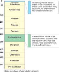
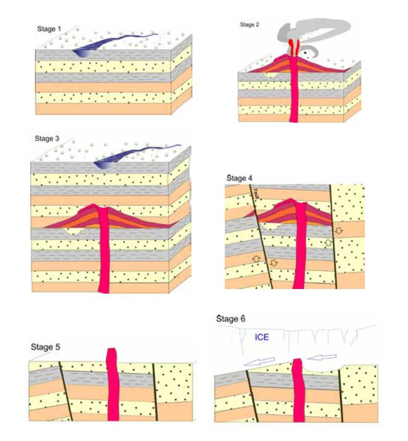
Stage 1. Some 350 million years ago, during the Carboniferous Period, the land you are standing on was a sparsely vegetated, low-lying plain close to the sea. Large rivers carried sand, silt and mud to be laid down on flood plains and in coastal lakes and lagoons.
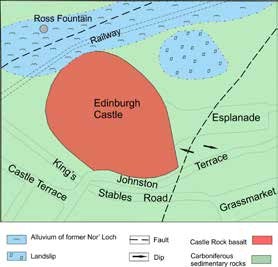
Stage 2. The first volcanic eruptions of the Arthur's Seat Volcano began 340 million years ago and it was at this time that the Edinburgh Castle Rock vent formed. Molten rock (magma) forced its way up to erupt at the surface as basalt lava flows and volcanic ash. As the volcanic activity died down, the magma in the vent cooled to solid basalt.
Basalt is typically black and fine-grained which means that the mineral crystals of which it is composed cannot be seen with the naked eye. When a very thin slice (a ‘thin section') of the rock is viewed with a petrographic microscope though, a mosaic of interlocking silicate minerals is revealed — feldspar crystals in shades of grey, white and black, and olivine in many refractive colours.
The Castle Rock vent was once thought to be Microscope view of a basalt from the Castle the source of the oldest lava of Arthur's Seat volcano, but modern geochemical analyses do not support this correlation. By about 335 million years ago, the volcano was extinct.
Stage 3. Over many millions of years, the volcanic rocks were buried by thousands of metres of sediment which hardened (lithified) into rocks.
Stage 4. Around 300 million years ago, the rocks were squeezed and folded, and uplifted to form hills. The strata were broken and moved along faults which developed during periods of earthquake activity.
Stage 5. Over a long time, the hills were worn down by erosion. The volcanic rock, which was eroded much more slowly, was itself gradually worn down to become what we now know as Arthur's Seat and Castle Rock.
Stage 6. Successive glaciations during the last 2.6 million years (the Ice Age) have further eroded the landscape. The hard basalt plug of Castle Rock resisted erosion better than the surrounding sedimentary rocks. Eastward flowing ice sheets, carrying large boulders, gouged out deep hollows forming today's Princes Street Gardens and Grassmarket. The basalt plug protected the softer strata in its eastern lee to form the gentle slope of today's Royal Mile from the Castle to the Canongate. The resulting landform is known as a crag-and-tail.
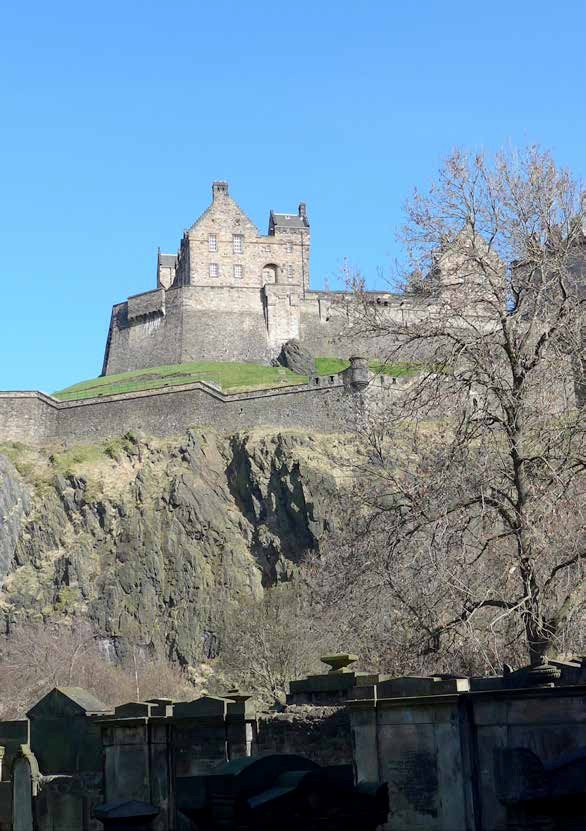
From 15,000 years ago, as the climate warmed, the last ice sheets receded and streams and small lochs occupied the natural marshy hollows between ridges. The slopes of today's city were covered by forests of oak and other deciduous trees. A pond to the north of Castle Rock preceded the artificial Nor' Loch which, until it was drained in the early 19th century, occupied the site of West Princes Street Gardens. Landslips affected the steeper slopes of the Royal Mile. Rock falls around the naturally jointed basalt of Castle Rock continue to the present day, necessitating periodic interventions including rock bolting and clearing of loose rock.
Edinburgh and the influence of humans
Castle Rock has likely been occupied since early prehistory with evidence of early Bronze Age occupation discovered at its foot in the Grassmarket in 2008 dating to c.2200 and 1950 years BC. Excavations within the Castle have provided archaeological evidence that the Castle Rock has been occupied from the late Bronze Age/Early Iron Age, with a range of buildings dating from c. 900 BC. During the 1st millennium BC the site became an important centre for the local British Iron Age populations. These were probably little affected by either the short term Roman occupation of the 1st century or that of the 2nd century AD.
By the 6th century AD the Castle formed a royal centre for the British Kingdom of the Gododdin. The name Din Eidyn first appears during this period in the poem The Gododdin which recounts the events of the Battle of Catterick in around 600 AD, during which the Goddodin were beaten by the Angles of Northumbria.
With the final fall of the British Kingdom of the Gododdin to the Angles around 638, the crag's natural defensive position made it an important strategic site for their kingdom of Northumbria on its north-western boundary. The earliest building seen today is the Chapel which was built in about 1130 AD from dressed blocks of sandstone. It was dedicated to Queen Margaret of Scotland, later St Margaret. Throughout the Middle Ages and even until 1745, when it was last used as a fortification, the Castle stronghold developed and was subjected to many sieges and bombardments.
The current layout of Edinburgh's Old Town is dictated in part by the layout of the geography of the crag-and-tail and was established during the early 12th century. Most of the early domestic buildings on the easterly sloping tail of the crag were constructed of wood until repeated conflagrations compelled the imposition of laws, dating back to 1425, which required houses to be built of stone. The preferred building materials were wrought from local Carboniferous sandstones. These were formed mainly in rivers and are composed of naturally cemented sand-sized grains of mainly quartz with some feldspar (black and white in thin section) together with iron- rich minerals and muscovite mica.
In the Old Town during the 19th century, the earlier tenements of Castlehill, the Lawnmarket and the Grassmarket were rebuilt. The building of the New Town commenced in the late 18th century and continued apace during the 19th century. From the mid-19th century as good local stone became used up, sandstone was imported from other parts of Scotland and northern England. Modern buildings, in contrast, employ a wide range of igneous, metamorphic and sedimentary rock types, often used as thin cladding panels to steel and concrete structures.
The Walk
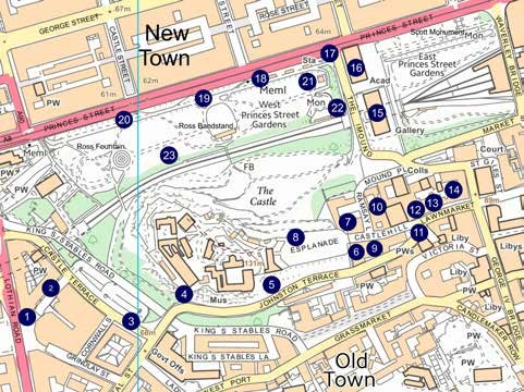
1. [NT 24803 73374] Usher Hall
We start at the Usher Hall (designed by J Stockdale Harrison, 1910–1914), constructed of sandstone from Darney, Northumberland and Leoch, near Dundee, with a base course of the 470 million year old, silver-grey, Rubislaw Granite from Aberdeen - a rare use of granite in Edinburgh.
2. [NT 24849 73421] Saltire Court and Castle Terrace
Saltire Court and Castle Terrace buildings occupy the ‘Hole in the Ground' formed in 1966 when the United Presbyterian Synod Hall (James Gowans, 1875), later a cinema, was demolished along with flanking buildings (School Board Office, Robert Wilson, 1886; and Parish Council Office, MacGibbon & Ross, 1886). The intention was to build an Opera House, then a hotel. Saltire Court (Campbell & Arnott, 1991) is faced with Carboniferous Stainton Sandstone from Barnard Castle and Permian red sandstone, of desert origin, from Gatelawbridge, Thornhill. The base course is formed from two types of igneous rock from Sweden. One is a dark grey coarse-grained diorite from Gunnebo. It has the trade name of Edelhammar. The other, known as Blaubrun granite, is from Flivik. It is a pale pinkish-grey granite with brown feldspars. It has a flame-finished texture. Both rock types are about 1800 million years old.
3. [NT 24986 73365] Castle Terrace tenements
The Castle Terrace tenements between Cornwall Street and Spittal Street (James Gowans, 1868) were constructed of sandstone possibly from one of Gowans' quarries at Redhall, near Colinton. Contorted beds can be seen in the sandstone masonry of No. 23. These formed as water was expelled from the sediment shortly after it was laid down in a river.
4. [NT 25079 73398] Johnston Terrace
Walking eastwards along Johnston Terrace we see superb views of the Castle Rock crag. Observe here the well-developed pattern of steeply dipping joints in the basalt cliff.
5. [NT 25246 73428] Johnston Terrace opposite Castlecliff
At Johnston Terrace opposite Castlecliff the contact between the basalt and the pale grey sedimentary rocks is visible below the ramparts of the Half Moon Battery. Away from the contact, and to the east of a small fault, the rocks dip gently towards the east.
6. [NT 25395 73479] Cannonball House
The Cannonball House, constructed of sandstone and basalt rubble, is at the top of the steps in Castle Wynd North. It was built for Alexander Muir and his wife in the late 16th century and was rebuilt in 1630. In 1913 it was reconstructed by John A Carfrae as an annexe to Castlehill School (see stop 9, below). Different explanations have been suggested for the origin of the cannonball which is embedded in the western gable of the building. One explanation is that it was fired from the Castle in 1745. An alternative view is that it was placed there by engineers to mark the precise height above sea-level of the fresh springs at Comiston, some 4 km to the south. These springs provided Edinburgh with its first piped supply of fresh water in the 17th century.
7. [NT 25375 73530] Ramsay Garden
Ramsay Garden was a Town-and-Gown hall of residence (S Henbest Capper and Sydney Mitchell, 1892–4) and block of flats built for Patrick Geddes. It incorporates the poet Allan Ramsay's House of c. 1740. Red sandstone was used for 19th century work.
8. [NT 25293 73519] Views from the Castle Esplanade
The views from the Castle Esplanade are spectacular. In the distance to the south lie the Pentland Hills formed of Devonian volcanic rocks. Looking north across the New Town, there are views towards Calton Hill, another part of Edinburgh's extinct volcano, and to the Firth of Forth and Kingdom of Fife. The Castle Esplanade was widened in 1816. On the south side it was given decorative railings and walls plus dummy turrets and sentry boxes built of local sandstone. Masonry of the easternmost turret displays tubular structures possibly formed by burrowing worms or shells. Pink and grey sandstones can be seen on the turret on which there is a memorial to the Earl of Leven and his Regiment of Foot, raised in 1689.
There are more memorials on the north side. The Celtic Cross commemorating the Scottish Horse (Stewart McGlashan & Son, 1905) uses a 406 million year old pink granite from Peterhead, Aberdeenshire. Ensign Charles Ewart's memorial is a block of grey Swedish "granite" prepared by William Kininmonth in 1938. Set into the paving behind the tomb is his original headstone, a flagstone brought from a Salford churchyard. A sandstone cross, designed by Sir John Steell in 1875, commemorates Colonel Kenneth Mackenzie of the Gordon Highlanders. The obelisk in Peterhead granite is to the 72nd Duke of Albany's Own Highlanders, by McDonald, Field and Co. in 1882-3.
Both the wall behind the Dry Ditch, which dates from the 17th century, and the Gatehouse of the Castle, which was erected in 1886–8, are built of coursed squared rubble of pinkish sandstone. This possibly came from Craigmillar in south Edinburgh. Pale yellow sandstone surrounds were used for slits, entrances and alcoves, such as those for the bronze statues of William Wallace and Robert the Bruce, which were added in 1929.
9. [NT 25415 73486] Scotch Whisky Heritage centre
The Scotch Whisky Heritage centre was formerly Castlehill School. It is built mainly of ashlar of "blue" Hailes sandstone, from west Edinburgh. It also includes ample dressings of red Corncockle from Lochmaben in Dumfries and Galloway, which originated as desert sand in Permian times. The architect was Robert Wilson and the start date of 1887 is engraved on the wall on the Johnston Terrace side.
10. [NT 25420 73578] Tolbooth Parish Schools
On the east side of Ramsay Lane are the Tolbooth Parish Schools (Patrick Wilson, 1837) and Dr Guthrie's Ragged School (David Rhind, 1850). White Cullalo sandstone, from Aberdour in Fife, has been used as a re-facing stone.
11. [NT 25498 73524] The Tolbooth Church
The Tolbooth Church (James Gillespie Graham and A W N Pugin, 1839–44), which now houses the Edinburgh International Festival Hub, was constructed of
12. [NT 25507 73549] Mylne's Court
Mylne's Court was built in 1690 by Robert Mylne of Balfarg, Master Mason to the Crown from 1668 until his death in 1710. The west side was demolished in 1883. The court was restored in 1970 as the Edward Salvesen Hall on the north side, and the Philip Henman Hall on the south side.
13. [NT 25549 73569] Gladstone's Land
The 16th Century Gladstone's Land, forming the rear wing of James Court, was bought in 1617 by Thomas Gladstone who in 1620 extended it southwards to produce a new front onto the Lawnmarket.
14. [NT 25586 73604] Lady Stair's Close and Wardrop's Court
Lady Stair's Close and Wardrop's Court were rebuilt in the 1890s on sites of demolished properties. On the west side of Wardop's Court is Lady Stair's House, built for Sir Walter Gray in 1622. It was restored in rubble and dressed sandstone by George S Aitken, reinterpreting early 17th century Scots architecture. Restoration was completed in 1897.
The view from New College looks north down The Mound towards the art galleries and the Scott Monument. East and West Princes Street Gardens occupy the hollow which was the site of Nor' Loch. During the Quaternary (the last 2.6 million years) ice eroded the hollow by exploiting a zone of weakness in the underlying sedimentary rocks caused by a fault. The floor of the hollow is underlain by alluvial sand and silt.
15. [NT 25436 73745] The National Gallery
The National Gallery (William Playfair, 1854) with Ionic columns was constructed of
16. [NT 25396 73826] The Royal Scottish Academy
The Royal Scottish Academy (William Playfair,1822–26) displays Greek Doric columns of sandstone from Edinburgh's most famous quarries at Craigleith, together with stone of similar properties from Cullalo. Playfair enlarged the gallery from 1831–36, and brown Binny sandstone, seen in the more recently constructed columns, was also used.
17. [NT 25345 73848] The statue of Allan Ramsay
The statue of Allan Ramsay (Sir John Steell, 1850) is carved out of Italian Carrara Marble. Standing on a sandstone pedestal designed by David Bryce, it towers above the Floral Clock at the east entrance to West Princes Street Gardens.
This is a good place to conclude the walking tour but there are many interesting monuments in West Princes Street Gardens, a selection of which are described below. The gardens were laid out by James Skene for the Princes Street proprietors around 1820. The gardens were acquired by the city in 1876 and further landscaped by Robert Morham.
18. [NT 25199 73803] Royal Scots Greys
Royal Scots Greys (Birnie Rhind, 1906): a bronze horse and trooper on a plinth of cross-bedded brown sandstone.
19. [NT 25199 73803] The Scottish American War Memorial
The Scottish American War Memorial (R Tait Mackenzie, 1924–27): in front is a bronze kilted soldier and as a backdrop bronze frieze panels fixed to sandstone from one of the Ravelston quarries, west Edinburgh.
20. [NT 25199 73803] Statue of Dr Thomas Guthrie
Statue of Dr Thomas Guthrie (F W Pomeroy, 1910) is believed to be carved out of Portland Stone, a Jurassic limestone commonly used in London, from the Isle of Portland, Dorset. It rests on a plinth of grey granite.
21. [NT 25100 73776] Gardener's Cottage
Gardener's Cottage (Robert Morham, 1886), constructed of red sandstone.
22. [NT 24972 73736] Royal Scots Memorial
Royal Scots Memorial (Frank Mears & Partners, 1950) in sandstone from Doddington, near Wooler in Northumberland.
23. [NT 25326 73802] Glacial erratic block of coarse-grained Norwegian granite
Glacial erratic block of coarse-grained Norwegian granite stands by the main footpath to the west of the Ross Bandstand. Donated in 1978 the block commemorates the Norwegian Brigade and other army units who trained in Scotland during the 2nd World War.
From here, if returning on foot towards the starting point of the itinerary, firstly walk past the Ross Fountain. The fountain was cast in iron by A. Durenne of Paris for the International Exhibition of 1862 and then purchased and donated to the city by Edinburgh gunsmith Daniel Ross. Cross over the footbridge over the railway. Here you are close to the base of Castle Rock.
A path around the west side of the crag leads up to Johnston Terrace.

