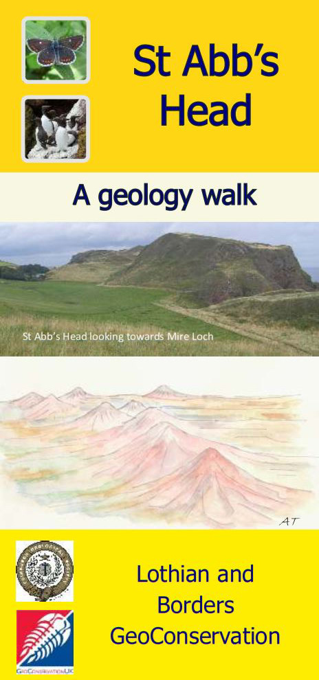
St. Abb's Head: a geology walk
Lothian and Borders GeoConservation Group
Full colour illustrated PDF download
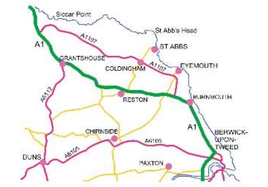
Visiting St. Abb's
St. Abb's Head is a National Nature Reserve with spectacular cliffs, a small loch and many nesting seabirds during the summer. The headland is managed by the National Trust for Scotland and the footpaths are accessible all year round. For opening hours of the NTS nature centre visit https://www.nts.org.uk/visit/places/st-abbs-head
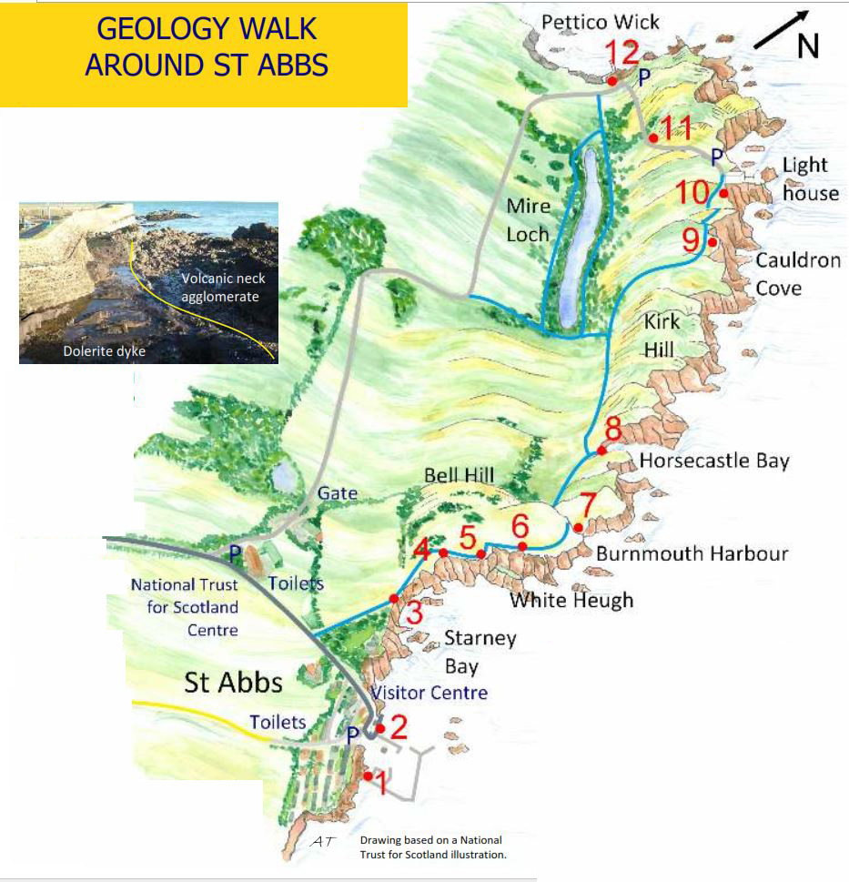
Parking at St Abb's There is a National Trust for Scotland car park 500 m west of the village (free for NTS members) and several car parks at St Abbs harbour for which there is a charge. There is limited road parking in St Abbs. There are public toilets near the NTS car park and at the harbour. St Abbs Visitor Centre can be found on the road above the harbour. The walk from St Abbs to Pettico Wick is about 2 km each way.
SAFETY WARNING Visit St Abb's Head at your own risk. The sea cliffs are steep and rocky. Grass slopes may be hazardous in wet and wintry conditions. Please do not use hammers.
Acknowledgements
Text, illustrations, images and design: Alison Tymon. Technical information: David Stephenson
Northern Brown Argus and Bridled Guillemot images©National Trust for Scotland. Produced by the Lothian and Borders GeoConservation Group of the Edinburgh Geological Society, a charity registered in Scotland. Charity No: SC008011
© 2017 Lothian and Borders GeoConservation Group https://www.edinburghgeolsoc.org/home/geoconservation/
Geological history
The Iapetus Ocean lay between two continents which moved towards each other for about 30 million years, until they finally collided about 420 million years ago. As the Iapetus oceanic crust slid beneath a huge continent the oceanic floor sediments were stripped off, folded and faulted.
The thickened crust rose to form mountains. Conglomerates and sandstones were deposited in valleys as the mountains were weathered and eroded. During the final phase of the collision, about 400–390 million years ago, a line of small volcanic cones erupted lavas onto the plains and river valleys.
Later faulting caused the rocks on the NE side of the St Abb's Head Fault to move downwards relative to older rocks on the SW side of the fault. A lamprophyre dyke was intruded 400 million years ago.
Dolerite dykes were intruded 300 million years ago. This area has been just above or below sea-level for most of the last 300 million years and any rocks deposited on top have been eroded away. In the last two million years, the area has been regularly covered by ice sheets. Since the ice melted, weathering, rockfall and marine erosion has shaped the coastal landscape.
The rocks of the St Abbs area
Igneous activity
Igneous activity is the term used for rocks and features formed when magma crystallises above or below the surface. Magma collects in the crust wherever increased temperature, commonly accompanied by decreased pressure, results in melting of rocks. Active volcanoes have magma chambers a few kilometres below the surface. Magma reaches the surface through pipes and fissures which cut through the surrounding rocks and is either erupted as lava or explodes as volcanic ash. Magma remaining in fissures after the eruption is over, crystallises as sheets of chilled rock called dykes.
Igneous rocks
All rocks are made of minerals. Minerals have specific chemical compositions and properties. Igneous rocks vary in composition and colour according to the proportions of their component minerals. Dolerite is a dark-coloured rock with a high proportion of iron and magnesium-rich minerals. It cooled relatively slowly at depth in a dyke and hence the individual crystals are clearly visible. Magmas which contain more silica crystallise into rocks which are paler in colour, such as andesite, which is a very common volcanic rock, usually pink, grey or mauve in colour with a pale weathered surface. The crystals are too small to be seen without a microscope. Lamprophyres are peculiar igneous rocks containing dark micas, generally intruded as dykes.
The St Abbs volcanoes
The headland of St Abb's Head is carved almost entirely out of lavas, which are flows of molten rock across the earth's surface. These lavas were sticky and flowed slowly because they are composed of a silica-rich rock called andesite (named after the Andes Mountains). Between each lava flow there is commonly a reddened zone, because the lava may have been weathered for hundreds of years in a subtropical climate until the next lava covers it.
Well-layered purple and red-brown rocks between the lavas on St Abb's Head are sedimentary rocks composed exclusively of debris eroded from the volcanoes during floods and redeposited in rivers and lakes.
Several volcanic necks, the pipes below a volcano that carry magma up to the earth's surface, are found in the St Abbs area. Necks can be recognised because they consist of agglomerate, which is made of assorted blocks of local rocks carried by magma and gases as they force their way up the neck of a volcano during an eruption. During a violent eruption, the magma and gases explode and fragments of rock and lava are thrown out of the vent as volcanic ash. Blobs of lava splatter back onto the cone, along with large blocks of rock, but finer ash can be carried high into the atmosphere.
Sedimentary rocks
Sedimentary rocks are generally made of particles of mud, sand or pebbles and can include plant and animal material. They are usually laid down in layers (beds/strata). Sandstones are made of sand particles about 1–2 mm in size. Conglomerates are sedimentary rocks made from rounded pebbles, stones and cobbles in a sandy matrix. Greywackes are sandstones made of rock and mud grains eroded rapidly from high mountain chains and volcanoes and deposited in deep oceans. Southern Uplands greywackes often have a grey or green tinge because they were altered by the pressure of a collision between continents. New minerals, particularly chlorite which is a dull green colour, were able to grow between the mud and sand grains.
How old are these rocks?
Lavas and dolerites can be dated using radiometric dating, which measures the rate of decay of the radioactive minerals that they contain. The lamprophyre dyke near Horsecastle Bay, with a composition related to the St Abbs lavas, has been dated radiometrically and gives an age of about 400 million years which is assumed to be close to the age of the lavas. This is also significant as the dyke cuts through the conglomerates and sandstones, which must therefore be older than 400 million years.
Glaciation
During the last glacial event, at its maximum about 25,000 years ago, a huge ice sheet covered northern Britain, including the Southern Uplands and the adjacent North Sea area. Glacial till, a mixture of boulders, sand and clay, was left behind when the ice sheets melted. Patches of glacial till are found in the hollows between the exposed rocky crags on the headland. The fractured rocks of the St Abb's Head Fault were eroded by ice. Meltwater from ice sheets deepened valleys, such as that now occupied by Mire Loch. Sea level was as much as 25m higher about 14,000 years ago and remnants of old sandy beaches are found near Horsecastle Bay.
Geology walk around St Abbs
1 Dyke on south side of harbour wall [NT 92032 67264]
From the harbour car park, walk south along the harbour edge towards the lifeboat station.
Look over the wall to see the rocks to the south. The rocks of the headland are rough and jagged. They are part of the St Abb's volcanic neck. If the tide is low enough, you can see smooth rocks just below the wall.
This is a dolerite dyke, 14 m wide, which is younger than the volcanic rocks into which it was intruded and is about 300 million years old. The dyke is broken up by joints, which run parallel to the harbour wall and the edge of the dyke. The joints developed as the magma cooled and contracted.
2 St Abbs Neck [NT 91948 67364]
Walk around the edge of the harbour to the car park and stop by the crag in front of Rock House.
This crag is part of the St Abbs volcanic neck and the rocks are called agglomerates. Look closely at the crag to see a mixture of reddish or dark pink, rounded and angular broken blocks, reddened with iron minerals. The jagged rocks in the sea are all made of agglomerate covered with yellow lichens. If you look just below the sea-wall where the sea has smoothed the rocks, you can see the shapes and colours of the individual blocks more clearly. From the sea-wall, look across Starney Bay towards White Heugh, the steep cliff where many birds nest in the summer. The headland is made of resistant volcanic lavas.
3 View towards White Heugh [NT 91634 67661]
Walk up the hill to the church, taking care on the road. Use the walled footpath for safety. Cross the road and follow the coastal path to the cliffs where there is an interpretation board and a table with seats. This is a good place to look at the view. On your right are the jagged sea stacks of the St Abbs volcanic neck. Looking across Starney Bay, you can see the cliffs of the headland called White Heugh, made of the oldest of the St Abbs lavas. The rounded hill to the left of the coastal path, Bell Hill, is made of sandstones and red boulder conglomerates deposited about 400 million years ago. The lumpy conglomerate forms the grassy-topped cliff. The very obvious gully to the left of White Heugh has been eroded along weak, weathered rocks on the line of the St Abb's Head Fault.
4 Second seat on the coast path [NT 91646 67875]
Walk carefully along the cliff-top path towards White Heugh until you reach the second seat. Look down at the cliffs where you can see the orange conglomerates, which are made up of rounded pebbles of greywacke, the dark sandstones which make up most of the Southern Uplands of Scotland. Beyond the orange conglomerates, the purple lavas of White Heugh are clearly seen.
5 White Heugh [NT 91723 68005]
Continue up the coastal path until you reach the high point. There is a deep gully between the footpath and the sea cliff at this point. It marks the position of the St Abb's Head Fault, a major break in the rocks which has been eroded to form the Mire Loch valley. The dramatic pinnacles above the gully look like an impressive geological feature, but they are the same composition as the volcanic rocks around them though they have been exposed to deep weathering at the top of the cliff.
6 Glacial deposits [NT 91797 68096]
As you walk along the path, look towards the top of the cliff. An orange scar of loose rock, where the turf is falling away down the cliff, has exposed glacial sand and gravel. As you continue along the path, look towards Mire Loch and imagine the valley flowing with meltwater carrying debris from the melting of an ice sheet.
Mire Loch is an artificial lake created around 1900 by local landowners for fishing and waterfowl hunting.
7 Burnmouth Harbour [NT 91905 68344]
Walk down the steep stepped path towards the sea, taking care on slopes if the weather is wet. The lowest grassy slopes are underlain by gravels and sands, part of an earlier beach. The attractive dark red rocks and rounded pebbles on the beach are andesite lavas. Andesites are often grey or purple in colour but here they have been reddened by iron-rich waters moving through the rocks. Minor faults are filled in places with white quartz. If you look at the smooth surfaces, you can see that the rocks are made of small, angular pieces of pink, grey, orange or dark red rocks embedded in a matrix of dark red or pink rock.
These rubbly lavas are formed when the solid crusts from the top of a slow-moving lava flow are engulfed in the molten rock below, giving a rock with broken, angular fragments, as shown in the drawing below.
8 Horsecastle Bay [NT 91763 68445]
Follow the path 100 m to the next bay which is eroded along the Horsecastle Fault. The cliff on your right as you face the sea is made of irregular layers of tough lavas and less resistant rocks, all of which slope down towards the sea. It is thought that these layers of solid lava slid down the side of a volcanic cone like rafts, perhaps because they were dislodged by an eruption or lubricated by water during a rainstorm. The northern side of the bay, on your left as you face the sea, is also composed of volcanic rocks. You will be able to see the features better if you climb the small hill on your right and look down into the bay.
At the base of East Hurker, the regular well-layered beds which slope down to the sea are made of volcanic debris that was eroded from the volcano and redistributed by floods and rivers.
In effect, they are sedimentary rocks formed from volcanic particles and give very colourful beach pebbles at Horsecastle Bay. They are overlain by a thick layer of purple lava.
9 Cauldron Cove [NT 91493 68965]
Go through the gate and follow the path north-east towards Mire Loch. The crags to the right on Kirk Hill are made of resistant lavas, whereas the small valleys which cross St Abb's Head are underlain by further sedimentary beds of bedded volcanic debris which weather and erode more easily than the tough, crystalline lavas. At a footpath junction, continue straight up along the coastal path and stop at the highest point.
The path follows a valley eroded into the less resistant sedimentary beds which reach the sea at Cauldron Cove, which you can see below you. The steep right hand cliff is composed of thick lavas, cut by a minor fault marked by a reddish gully at the end of the headland. The sedimentary beds have been eroded by the sea to form the cove.
10 Lighthouse [NT 91439 69140]
Continue along the right-hand path towards the lighthouse, taking care on the steep grassy slopes above the cliffs. Just before you reach the lighthouse there is a deep inlet. The cliffs of the inlet show two dark-coloured, rugged lava flows, separated by an obvious irregular layer of red rocks. The reddened rocks were formed by subtropical weathering of the lower lava, before it was overridden later by the upper lava. Follow the path behind the lighthouse buildings to the small car park at the end of the metalled road. You can admire the dramatic cliff scenery around the lighthouse, all formed from the thick purple lava flows.
11 Bend in the road [NT 91097 69013]
Follow the road past small crags of lavas until you reach the sharp right-hand bend overlooking Mire Loch and Pettico Wick, the cove to your right. You now have a view across the St Abb's Head Fault to the hills and cliffs formed by the greywackes (sandstones) of the Southern Uplands. These greywackes are about 430 million years old and are the oldest rocks seen in the St Abbs area.
12 Pettico Wick [NT 90852 69116]
Walk down the road to reach the cove of Pettico Wick. From the car park on the right of the cove you have a good view of the greywacke cliffs with their folds eroded by the sea.
In the course of the collision more than 420 million years ago, the greywackes were squeezed into the sharp folds you can see on the cliffs. Walk down the grassy slope to the cliffs on the far side of the cove for a closer look at the greywackes. As you do so, you are crossing the line of the St Abb's Head Fault.
Return to St Abbs
You can walk along the road back to the National Trust for Scotland car park, enjoying the good views over St Abb's Head and Mire Loch. Alternatively, there are footpaths on either side of Mire Loch which will take you back to the cliff-top path to St Abbs village. In both cases the distance is about 2 km.


