Show interactive timeline
The lead, zinc, copper and nickel ores of Scotland
By G.V. Wilson, with contributions by John S. Flett
Bibliographic reference: Wilson, G.V. The lead, zinc, copper and nickel ores of Scotland. Special Reports on the Mineral Resources of Great Britain. Vol. XVII. Edinburgh: HMSO, 1921.
Memoirs of the Geological Survey, Scotland. Special Reports on the Mineral Resources of Great Britain. Vol. XVII.
The lead, zinc, copper and nickel ores of Scotland. By G. V. Wilson, B.Sc. With contributions by John S. Flett, LL.D., F.R.S.
Published by order of The Lords Commissioners of His Majesty's Treasury.
Edinburgh: Printed Under The Authority of His Majesty's Stationery Office by Morrison & Gibb, Limited, Tanfield.
And to be purchased from E. Stanford, 12, 13 And 14 Long Acre, London; W. & A. K. Johnston, Limited, 2 St. Andrew Square, Edinburgh; Hodges, Figgis & Co., Limited, 104 Grafton Street, Dublin. From any Agent for the sale of Ordnance Survey Maps, or through any Bookseller, or from the Director-General, Ordnance Survey Office, Southampton. 1921. Price 7s. 6d. Net,
Preface
In Scotland the ores of lead and zinc have a wide distribution and have been worked for several centuries, though only on a small scale, except at Wanlockhead and Leadhills. Copper ores are less frequent, and nickel ores are found in only a few places. Mr. Wilson has collected information from a great variety of sources, and has personally inspected all the more important occurrences. The chapters on Caithness, Orkney and Shetland were contributed by me. It is very probable that many of the less important veins have escaped notice; but this Memoir contains a brief general account of the known mineral resources of Scotland in respect of lead, zinc, copper and nickel ores. We are indebted to many proprietors, factors, agents and mining engineers for assistance in compiling this handbook, and especially to the managers of Leadhills, Wanlockhead, Wood of Cree and Tyndrum Mines, who have given us every facility for examining their mines and records.
John S. Flett, Director. Geological Survey Office, 28 Jermyn Street, London, S.W. 1, 8th September 1920.
Figures and plates
Chapter 1 Lead and zinc ores
Introduction
Lead ores have a wide distribution in Scotland and, as
The principal districts in which lead mining has been actively carried on during the past century are: Strontian and Islay in Argyllshire, Tyndrum in Perthshire, Minnigaff in Kirkcudbrightshire (near Newton Stewart), Leadhills in Lanarkshire and Wanlockhead in Dumfriesshire. Of these, Leadhills and Wanlockhead have produced ore continuously during the whole period. Mining in the other districts named has been in abeyance for a considerable number of years, but owing to new conditions created by the war the old mines at Tyndrum and Newton Stewart are being reopened and trials have also been made on a new vein at Achanarras, in Caithness.
Historical notes
Metalliferous mining is an old industry in Scotland, and the mining of lead ores was probably carried on on a small scale at different centres at a very early period. The finding of bronze and stone implements
Up to about the sixteenth century
The period from the latter part of the fifteenth to the beginning of the seventeenth century was one of great activity in mining and prospecting, due mainly to the discovery of the gold-bearing gravels of the Leadhills district.
In 1606 great excitement was caused by the discovery of the silver-lead mine at Hilderstone,
A slump in mining enterprise seems to have set in during the latter half of the seventeenth century, but interest revived with the discovery of the Alva silver mine in 1711
From this time to the end of the Napoleonic wars the lead industry appears to have been in an active state, and large quantities of ore were raised. After the signing of peace in 1815 the price of lead fell rapidly from £32 per ton in 1809 to £13 in 1829. Under these conditions several of the mines were closed down, but apparently only temporarily, as between 1840 and 1880 no less than twenty mines were worked for lead ore, including Woodhead, near Carsphairn, which was discovered in 1839. In the early days the ore was practically always smelted locally in shallow hearths, which were often placed in exposed positions so as to take advantage of the prevailing winds, and peat was generally used for fuel. Coal was first used for the purpose in Scotland at Wanlockhead in 1727, and the hearths of that period have by gradual improvements been developed into the present type of Scotch hearths. The Strontian furnaces were built about 1730, and those at Tyndrum in 1768–9.
Many of the small mines appear to have had furnaces of their own, but others apparently were never equipped with smelting appliances, and the ore was often transported either to Holland or to England. These early furnaces were very inefficient, and a large proportion of the lead was lost in the form of waste fumes. Latterly, by the addition of long condensing flues, much of this fume lead was saved. Straight flues, such as those to be seen at Woodhead, were first used, but it was subsequently found that by "zig-zagging" them a much larger proportion of lead could be recovered. Leadhills and Wanlockhead were fitted with this type, but the former were abandoned about 1890, and since that time the Wanlockhead furnaces, together with some in Glasgow, have been the only ones working in Scotland.
The working of zinc ores is a small and recent development of Scottish mining, but a large extraction plant for treating imported ores has recently been erected at Irvine, on the Ayrshire coast.
Statistics
Output of lead ore
Few records exist as to the early output of the mines. We find, however, that in 1466, James Lord Hamilton
Output of lead from Scottish mines during the period 1850–1920
| Name of Mine. | Periods of Working | Lead total output in tons | Lead Largest yearly output Tons. | Average Price of Lead per Ton. 1800–1919 | £ | s. | d. |
| Wanlockhead | Continuous | 87,000 app. | 2578 | 1800–1809 | 27 | 14 | 6 |
| Leadhills | Continuous | 85,000 app. | 2600 | 1810–1819 | 23 | 6 | 6 |
| Strontian | 1852–1872 | 1,156 | 239 | 1820–1829 | 29 | 7 | 0 |
| Tyndrum | 1856–1865 | 430 | 94 | 1830–1839 | 16 | 11 | 0 |
| — | — | 1840–1849 | 17 | 15 | 7 | ||
| E. Blackeraig | 1854–1881 | 2,685 | 341 | 1850–1859 | 21 | 17 | 5 |
| W. Blackeraig | 1853–1872 | 975 | 383 | 1860–1869 | 20 | 9 | 3 |
| Cairnsmore | 1853–1860 | 144 | 91 | 1870–1879 | 20 | 9 | 3 |
| 1880–1889 | 13 | 8 | 10 | ||||
| Undifferentiated Kirkcudbrightshire Mines | 1853–1859 | 552 | 151 | 1810–1899 | 11 | 17 | 7 |
| 1900–1909 | 14 | 6 | 1 | ||||
| Wood of Cree | 1917–1920 | 6 | 6 | 1910–1919 | 21 | 10 | 1 |
| Carsphairn (Woodhead) | 1853–1874 | 867 | 92 | ||||
| Islay | 1862–1882 | 1436 | 218 | ||||
| Lossiemouth | 1881–1882 | 6 | 6 | For fuller details of the price of lead since 1873 see Home Office Reports, Mines and Quarries, Part III | |||
| Tomnadashan | 1861–1862 | 1 15 cwt. | 1 15 cwt. | ||||
| Creetown | 1866–1868 | 8 | 6 | ||||
| Tyndrum | 1919–1920 | 261 | 4 | ||||
| Tyndrum | 1911–1925 | 339 |
Output of zinc ore
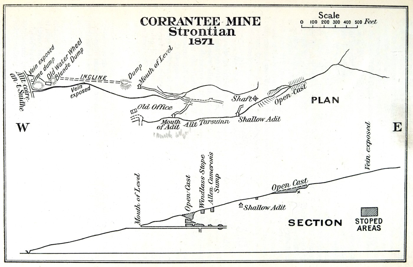
Zinc ore has been worked only on a small scale, and the earliest record is for 1865, when 33 tons of blende were raised at Black Craig Mines (Newton Stewart). From that time till they closed down in 1882 a fairly constant but small output of ore was kept up. In 1871, 30 tons of blende were mined at Corrantee (Strontian).
Prior to 1880 the blende was not saved at Wanlockhead and the slimes were allowed to run to waste. In that year, however, 39 tons were produced, and since then the output from the mine has steadily increased up to about 1000 tons per annum. No zinc ore is produced at Leadhills.
The veins
Practically all the Scottish lead veins are of the type generally known as "cavity fillings or fissure lodes". Simple veins with well-defined walls are the most common, and they often show evidence of repeated opening and refilling of the fissures. In the Newton Stewart area, on the other hand, many of the veins are of a composite nature; their walls are ill-defined, and the country-rock is much broken up and strung through with veinlets of ore. The "bearing-ground", as this impregnated zone is called, may be as much as 20 yds. in width, and is liable to contain pockets of ore at any part of its course, after the manner of a stockwork.
In a general way the contents of the veins may be divided as follows:
- The Ores, Main and Accessory (1) Primary ores as originally deposited. (2) Secondary ores (due to alterations, of the primary ores
- The Gangue Minerals.
- Rock Inclusions.
The distinction between main and accessory ores is, of necessity, governed by the economic conditions prevailing at the time, and by improvements of plant or in method of working an accessory ore may become of sufficient value to repay the cost of extraction, and may even become the principal ore for which the deposit is worked. In many of the Scottish veins the ore is complex, being an intimate mixture of various minerals which are too finely disseminated to be separated from one another, or from the gangue, by ordinary washing processes. In former times the miners were unable to cope with this type of ore, and it was often left in the mines or thrown away on the dumps. With the improved machinery and processes now available these mixed ores can be worked up, and the different minerals separated. At the present time plant is being fitted up to deal with some of the old dumps containing these complex ores.
The following tables give the common ores of lead and zinc as found in Scotland, the percentage of metal being the theoretical amount present in the minerals:
Lead ores
| Ores | Chemical Composition | Percentage of Lead | |
| Primary | Galena | PbS | 86.6 |
| Primary | Jamesonite | Pb,Sb2S5 | 50.8 |
| Secondary | Cerussite | PbCO3 | 73.0 |
| Secondary | Anglesite | PbSO4 | 68.3 |
| Secondary | Pyromorphite | Pb5Cl(PO4)3 | 75.8 |
| Secondary | Mimetite | Pb5Cl(AsO4)3 | 69.6 |
At the present time galena is the only ore worked, but a little jamesonite is occasionally met with. In the early days cerussite and pyromorphite were worked in the oxidised portions of some of the Leadhills veins.
Zinc ores
| Ores | Chemical Composition | Percentage of Lead | |
| Primary | Sphalerite, Blende, or "Black Jack | ZnS—(Fe and Mn). | 50–67 |
| Secondary | Calamine. | ZnCO3. | 52.0 |
| Secondary | Hemimorphite. | H2Zn2SiO5 | 54.2 |
Sphalerite is the only zinc ore mined in Scotland.
The metallic sulphide ores usually contain small quantities of the precious metals, but up to the present silver is the only one extracted from Scottish lead and zinc ores. The amount of silver varies greatly in ore from different localities, and even in ore from any one mine. The galena formerly raised at Coire Buidhe Hill, on the south side of Loch Tay, is said to have yielded 600 oz. to the long ton, but this is exceptional, and the amount of silver in Scottish lead usually runs from 2–10 oz. to the long ton. The amount of gold present in the ore is minute and often has not been estimated. In a complex lead-zinc-copper ore formerly worked at Stronchullin,
Gangue minerals
The common gangue minerals of the veins are quartz, calcite, dolomite and barytes. In many instances they occur in subordinate quantities only, and usually are too much mixed with impurities to be of economic value. In fact, in some cases they are detrimental. For instance, the presence of barytes in conjunction with zinc-blende makes the separation of the latter in a pure state a, rather difficult task owing to the two minerals having similar specific gravities.
Rock inclusions
Much of the material in the veins consists essentially of a breccia of country-rock cemented together by ore-bearing gangue minerals. Consequently a large quantity of rock has to be worked and brought to the surface, and after the extraction of the ore the residue may be divided into three main categories:—
- 1. Hand-picked tailings
- 2. Gravel and sand
- 3. Slimes
The first are of little value except for road-metal or railway-ballast, but the other two are now finding a use in the manufacture of concrete and cement, and at the present time are worth as much as 10s. per ton.
Distribution of the veins
In the following account of the occurrences of mines and veins of lead and zinc ores in Scotland, it has been found convenient to divide the country into a number of areas, arranged more or less geographically from south to north. These are as follows:
- The Southern (Area I.)
- The Central (Area II)
- The Northern (Area III.)
- The Orkneys and Shetlands (Area IV.)
In a general way the Scottish veins can be divided into four main systems according to direction, namely, north-east, east-and-west, north-west, and north-north-west.
Chapter 2. Lead and zinc ores. Area I
This area comprises the country south of a line joining the Firths of Forth and Clyde. It is by far the most productive area in Scotland, as it contains the extensive mining fields of Leadhills, Wanlockhead and Newton Stewart. Most of the veins are found in the belt of Silurian strata which stretches practically continuously across the country from Port Patrick to St. Abbs' Head. In the following description of the veins of this area the more important districts are considered first, and the isolated occurrences are discussed individually at the end of chapter 3.
The Leadhills and Wanlockhead district
Situation
This district, which contains the most productive lead mines in Scotland, is situated on the north slopes of the Lowther Hills on the borders of Lanarkshire and Dumfriesshire. The village of Leadhills, in Lanarkshire, lies at a height of 1200–1300 ft., and is the highest village in Scotland. Wanlockhead, in Dumfriesshire, is a little lower, from 1100 to 1250 ft. The two villages are a mile apart, and until eighteen years ago were very inaccessible. The nearest railway stations are either Abington or Elvanfoot, 7 and 5 miles respectively from Leadhills; and Sanquhar, in the Nith Valley, which is 10 miles from Wanlockhead. At the present time the district is served by a light railway which joins the main Caledonian line at Elvanfoot.
Maps: One-inch Ordnance and Geological, Sheet 15; six-inch, Lanark 46 S.E.; 49 N.E., S.E.; 5 N.W. ; six-inch, Dumfries 7 N.E. New editions of Lanark 49 N.E., S.E., and Dumfries 7 N.E., are engraving.
Geology
The district is situated in an area of Ordovician (Lower Silurian) rocks which have been intensely folded along N.E.-S.W. axes, and show an extraordinary repetition of their outcrops.
The general succession of the strata is as follows:—
| Thickness | ||
| Caradoc | Lowther Group | 1000 feet |
| Lower |
40–50 feet | |
| Llandeilo | Glenkiln Group | |
| Arenig | Radiolarian cherts | 60–70 feet |
| Volcanic and intrusive rocks | Base not seen |
The Arenig volcanic and intrusive rocks consists mainly of lava flows, sills, tuffs, and agglomerates of basaltic and andesitic nature. Only the upper members are seen, and, since the base of the series is nowhere visible in. Scotland, no estimate as to their total thickness can be attempted.
The Radiolarian Cherts immediately overlie the volcanic rocks, and there is a gradual passage upwards from them into the Glenkiln Group, which consists of alternating layers of black shale and chert. Above these lie the Lower
The Lowther Group, representing the barren mudstones or Upper Hartfell Series of the Moffat area, consists mainly of grey, sandy, micaceous shales, certain layers being also calcareous. Intercalated with these are grey, ferruginous, gritty beds (greywackes), some of which are also calcareous and have yielded a suite of Caradoc fossils from the Duntercleuch. A thin volcanic zone occurs sporadically near the base of the group. It is when the veins traverse the beds of this group that they are metalliferous. A number of later felsite dykes, probably of Lower Old Red Sandstone age, penetrate the rocks of the district. When fresh they are found to be of a pale grey colour. On microscopic examination they are seen to be much altered, and the felspars are replaced by sericite (mica). Occasionally they contain numerous cubes of pyrites which may attain a size of two inches in diameter. A few basalt dykes belonging to the typical Tertiary set of N.N.W. dykes are also met with in this area.
History
Leadhills
Thefirst record of mining in the district is that of a lead mine in Glengonnar being worked by the monks of Newbattle in 1239,
In the reign of James IV, the river gravels of this district were found to be auriferous, and the working and extraction of gold formed an important industry for a number of years. About this time it appears that lead-mining had been abandoned in the area, as lead was imported into the district for refining the gold.
Wanlockhead
These lead veins are said to have been discovered (more probably rediscovered) by Cornelius Hardskins The New Statistical Account of Scotland, vol. iv., 1845, Dumfries, pp. 299–304. See also Watson, in James Brown, The History of Sanquhar, 1891, pp. 424–442; and Edmond in same work, pp. 442–450; and Muir Porteous, God's Treasure-House in Scotland, 1876. (a German) during the minority of James VI. They were opened up by James Stampfield in 1680, who carried them on fairly sucessfully till 1691. He was succeeded by Matthew Wilson, who held the lease till 1710, and seems to have worked the Straitstep vein under the Dod Hill. In 1710 Matthew Wilson was succeeded by The Company for smelting lead ore with coal. They first wrought extensively in the Old Glencrieff and Belton Grain Veins, but without success. Later they were fortunate in discovering the New Glencrieff Veins, from which they raised a good deal of ore in a short time. In 1721 this company amalgamated with the Friendly Mining Society. The combined companies carried on the mines till 1727, and worked extensively in all the principal veins: New Glencrieff, Old Glencrieff, Cove and the Belton Grain. In 1727 the partnership was dissolved and the mining-field was divided between the Smelting Company and the Mining Society, who carried on separately till 1734, when both leases were resigned. That of the Smelting Company was held for a few years by Dean of Guild Wightman, one of the original partners, and that of the Mining Society was taken over by Alexander and William Telfer, who were unsuccessful at first, but eventually found good ore in the west branch of the
Output
In all probability the mines were worked only intermittently till the middle of the seventeenth century, but since that time they have practically been in continuous operation, and have yielded a fairly constant supply of ore. The total amount raised cannot fall far short of 500,000 tons. From 1700 to 1786 the annual output from Leadhills varied from 750 to 1000 tons of ore, and a similar amount was most probably produced at Wanlockhead. The following tables give the output since 1842: Compiled from "Mineral Statistics" (Mem. Geol. Surv.), and from Part III. of Mines and Quarries (Home Office Reports).</ref>
| Wanlockhead | Leadhills | ||||
| Periods. Inclusive. | Tons Lead Ore. | Tons Zinc-Blende. | Oz. Silver. | Tons Lead Ore. | Oz. Silver. |
| 1842–1850 | 8,479 | Nil | – | – | – |
| 1851–1860 | 8,722 | Nil | 25,500 | 5,454 | – |
| 1861–1870 | 10,271 | Nil | 47,985 | 10,740 | 12,573 |
| 1871–1880 | 12,841 | 39 | 56,362 | 18,661 | 28,507 |
| 1881–1890 | 20,246 | 285 | 115,546 | 20,973 | 117,349 |
| 189900 | 19,707 | 1,194 | 67,369 | 13,526 | 57,253 |
| 1901–1910 | 13,288 | 1,010 | 67,371 | 16,512 | 47,251 |
| Years. | |||||
| 1911 | 3,152 | 109 | 14,972 | 1,899 | 6,172 |
| 1912 | 3,330 | 952 | 16,650 | 1,749 | 6,121 |
| 1913 | 2,704 | 1,010 | 13,520 | 1,331 | 4,653 |
| 1914 | 3,234 | 1,057 | 19,404 | 2,145 | 7,508 |
| 1915 | 3,135 | 1,258 | 17,243 | 1,943 | – |
| 1916 | 2,333 | 960 | 12,832 | 1,874 | 4,731 |
| 1917 | 2,056 | 780 | 11,308 | 1,773 | 5,319 |
| 1918 | 1,715 | 865 | 11,147 | 1,952 | 5,856 |
| 1919 | 1,860 | 595 | 11,160 | 1,896 | 5,688 |
The veins and their contents
Almost all the veins of this district contain galena as the principal valuable mineral. A few, however, carry ores of copper in excess of the other sulphides, and have been worked for that metal. Most of them contain zinc-blende, but it is usually not in payable quantities, and so far has been worked in only one vein. The wide distribution of alluvial gold over the district leads one to suppose that auriferous quartz veins occur, but as yet they have not been discovered.
Silver — 1 oz. 18 dwt. per long ton
Gold — Traces per long ton
Surface indications
A striking feature in connection with this area is the small number of natural exposures of veins. In fact, in many cases the only surface indications—excepting, of course, the old mine dumps—are lines of springs and green patches along the hillsides. In the few instances where the veins are exposed they consist either of barren quartz or of a gozzan formed of broken country-rock mixed with a good deal of red, ferruginous clay, and usually little or no metallic ores are to be seen. Under these circumstances the discovery of so many veins in the district can only be attributed to the fact that in the search for gold the surface of the ground was broken up by innumerable costeen workings and hushes. At a later date other veins were no doubt found during the driving of cross-cuts and drainage-adits. A glance at the map
Relative ages of the veins
On the whole, the evidence on this point is meagre, but such as exists points to the veins of the W.N.W. to N.W. set being the older. Thus, for instance,
Relations between the types of country-rock and the shoots of ore
As already stated, the richest portions of the veins are found in the greywackes of the Lowther Group. This fact is due to these rocks consisting mainly of compact, hard felspathic grits, which naturally give rise to a loose, open breccia on fracture. Consequently when a line of fracture crosses this type of rock it is represented by a more or less open fissure suitable for the circulation of ore-bearing solutions.
When the veins cut through the cherty bands they contain only a little ore, owing to the shattery rock forming a fairly compact rubble, with only a few small interstices. In the black shales the movement has often given rise to an almost impervious material containing no open fissures, and the veins are only represented by crushed rock and thin strings of gangue minerals. These relations are exceedingly well seen in the northerly extension of the 160-fm. level in the
Nature and character of the veins
About 70 veins are known to occur in the district, and at some time or other lead ore has been produced from nearly all of them. At present only four are being worked: the
Mineralogy
The mining-fields of Wanlockhead and Leadhills are exceedingly rich in minerals, and several new species have been recorded from the mines. Many of the minerals occur in a variety of crystalline forms and are often of great beauty. The best specimens of primary ores and gangue minerals are usually obtained from large open cavities, and those of the secondary minerals from the smaller cavities in the oxidised parts of the lodes. Some specimens show signs of corrosion; and numerous interesting facts in this connection, and also in relation to the formation of pseudomorphs, can be seen and studied.
Primary main ores
Galena
Lead sulphide (PbS) is by far the most important mineral in the district, and until recently was the only ore worked. It usually occurs as massive, coarse-grained, crystalline aggregates, but fine-grained "steel ore" is occasionally found. Beautiful specimens, consisting of combinations of the cube and octahedron, are sometimes met with in the cavities in the
Zinc-blende—sphalerite
Zinc sulphide (ZnS) is an important and abundant constituent of some of the veins, but has only recently been worked. It sometimes occurs in massive aggregates free from other sulphides, but is more often mixed with galena and chalcopyrite. The usual colour is dark brown, but some of the better developed crystals, found lining cavities, are almost black (black jack).
Primary accessory ores
Chalcopyrite
Copper iron sulphide (Cu2S,Fe2Si3) is widely distributed throughout the district, but nowhere appears to occur in payable quantity, though one or two attempts were formerly made to work it. It is often associated with galena and zinc-blende, and then it appears to have been the first to crystallise out from the ore-bearing solutions.
Pyrites
Iron sulphide (FeS2). Ordinary iron pyrites is a common mineral in the area, both as a constituent of the veins, and disseminated through the country-rock. It occurs in a variety of forms and is occasionally beautifully tarnished. The common crystalline form developed is the cube, and in an occurrence noted in a felsite dyke cut in Glengonnar Mine the individual crystals were finely striated and up to 2 in. in diameter.
Jamesonite
A sulphantimonide of lead (2PbS,Sb2S3), with a pale grey colour and fibrous fracture, is an occasional constituent of the veins. It is nearly always associai. with galena.
Secondary ores (Reduction products)
Practically all the metallic sulphides already mentioned occur also as secondary growths on other minerals, and in all probability several generations of these ores exist in the veins.
Secondary accessory ores (oxidation products)
These minerals are usually restricted to the upper portions of the veins, but in the south end of the
Azurite
Azurite the blue basic carbonate of copper (2(CuCO3).Cu(OH)2), occurs under similar conditions to malachite.
Hydrocerussite
Hydrocerussite, hydrated carbonate of lead (Pb2(OH)2(CO3)2), occurs as scaly white coatings associated with cerussite and plumbocalcite in the
Plumbonacrite
Plumbonacrite is the name given to those varieties of hydrocerussite which possess a nacreous lustre.
Hydrozincite
Hydrozincite, hydrated carbonate of zinc (ZnCO3.2Zn(OH)2), occurs as a white incrustation on the walls of some of the levels.
Plumbocalcite
Plumbocalcite is the name given to the intermediate compounds between calcite and cerussite. It is almost certainly of secondary origin.
Aurichalcite
Aurichalcite, hydrated zinc and copper carbonate (2(ZnCu)CO3. 3(ZnCu)(OH)2), is of a pale green to sky blue colour, and occurs associated with malachite, leadhillite and hydrocerussite in some of the veins.
Haematite
Haematite, ferric oxide (Fe2O3), is often found in the oxidised tops of the veins. It occurs as botryoidal masses, and some of the best specimens have been obtained from the
Limonite
Limonite, hydrated ferric oxide (2Fe2O8.3H2O), is the most common product of the alteration of iron pyrites, and is found in all the lodes. It also occurs as pseudomorphs after cubes of pyrites in the auriferous gravels of the district.
Minium
Minium, oxide of lead (Pb3O4), is stated to have been found in the district.
Calamine or Smithsonite
Calamine or Smithsonite, zinc carbonate (ZnCO3) often occurs as an incrustation in the veins of the district.
Cerussite
Cerussite, lead carbonate (PbCO3), is a common oxidation mineral, and, in the massive form known as "grey lead ore", was formerly worked in the
Malachite
Malachite, green copper carbonate (CuCO3.Cu(OH)2), does not occur in any quantity, but is often found in the oxidised materials.
Hemimorphite
Hemimorphite, hydrated silicate of zinc (2ZnO.SiO2.H2O), occurs as fine crystals lining cavities, and was exceedingly plentiful at the south end of the 100-fm. level in the
Chrysocolla
Chrysocolla, hydrated copper silicate (CuOSiO2.2H2O), is usually found as an incrustation or staining in conjunction with decomposing chalcopyrite.
Pyromorphite
Pyromorphite, lead chlorophosphate Pb5C1(PO4)3, and Mimetite, lead chloroarsenate Pb5C1(AsO4)3, are common oxidation minerals of the district. They are isomorphous, and practically all mixtures from pure pyromorphite to pure mimetite are found. The specimens show a remarkable range of colour, but usually vary from olive-green to orange-red, or even yellow.
Vanadinite
Vanadinite, lead chlorovanadinate (9PbO.3V2O5.PbCl2), is an exceedingly rare mineral in the district, and so far has only been found in Belton Grain and Susanna Veins. It occurs both as individual crystals and as globular masses.
Anglesite
Anglesite, lead sulphate (PbSO4), occurs in many of the veins, and is often associated with lanarkite, linarite and cerussite. It usually occurs as long-bladed crystals, and the best localities are the Susanna and Belton Grain Veins.
Goslarite
Goslarite, zinc sulphate (ZnSO4.7H2O), is found as a feathery growth attached to the sides and timbers of some of the upper and dry old levels in the various mines.
Leadhillite
Leadhillite, hydrated carbonate and sulphate of lead (4PbSO4, 2CO3H2O), has been found in all the veins of the district except the Belton Grain.
Susannite
Susannite is a variety of leadhillite.
Lanarkite
Lanarkite, basic sulphate of lead ((Pb2O)SO4), is the rarest mineral occurring in the district, and has only been met with in the
Caledonite and Linarite
Caledonite and Linarite are two basic sulphates of lead and copper (PbCu)2(OH2)SO4, and PbCu(OH)2SO4. The first is green in colour and the second is azure blue. Both have been found in many veins in the district. They usually occur together, often with chrysocolla and malachite.
Gangue minerals
Quartz
Quartz, silicon dioxide (SiO2), is a common gangue mineral of the veins, and often occurs as beautiful crystals lining cavities. The individual crystals, however, are seldom large enough to be of economic value.
Calcite
Calcite, the hexagonal variety of calcium carbonate (CaCO3), occurs in a great variety of forms both massive and crystalline, and some specimens are of great beauty. The large cavities in the veins are often lined with large scalenohedra, "dog-tooth spar." In other cases the form developed is that known as "nail-head spar", and occasionally specimens are found with the latter type as a growth on the former, whose shape can be seen as a "ghost" inside the crystal.
Aragonite
Aragonite, the rhombic variety of calcium carbonate, is an occasional constitutent of the veins and often occurs in beautifully radiating clusters.
Dolomite or Pearlspar
Dolomite or Pearlspar, calcium magnesium carbonate (CaCO3.MgCO3), is fairly common. It possesses the usual faint pink colour and the crystals have the characteristic curved outlines. On exposure to weather the colour changes to light brown.
Witherite
Witherite, barium carbonate (BaO3), is one of the rarest minerals in Scotland. A cavity opened up early in the year 1918 at the 200-fm. level in the west - branch of the
Barytes
Barytes, barium sulphate (BaSO4), is a common gangue mineral, and numerous beautiful specimens of the cockscomb variety have been obtained from Wanlockhead Mines.
Gypsum
Gypsum, calcium sulphate (CaSO4), has occasionally been obtained in small crystals from Wanlockhead Mines. It also occurs in the fibrous variety sometimes known as satin spar.
Note— Many particulars of the minerals of this district will be found in Heddle's Mineralogy of Scotland, and collections of them may be seen in the Royal Scottish Museum, the Hunterian Museum, Glasgow, and at Wanlockhead and Leadhills.
Alteration of the ores (oxidation)
The percolation of surface waters into the outcrops of the lodes causes a number of chemical actions to take place whereby the original sulphide ores are decomposed and part of their content removed by solution, often to be precipitated again either as oxygen salts in the upper portions of the lodes where oxidising conditions exist, or as sulphides at greater depths under reducing conditions. This solution and reprecipitation of mineral matter in many cases has resulted in the secondary formation of rich pockets of ore in an otherwise poor vein.
Pyrites and chalcopyrite
Pyrites and Chalcopyrite are generally the first sulphides to decompose, and when in considerable quantities their oxidization gives rise to large amounts of limonite and hamatite, thus forming the well-known "gozzan" or "iron hat" of the miners' terminology. Several chemical equations have been devised to represent the reaction which takes place in the decomposition of common pyrites, but the net result appears to be the formation of ferrous sulphate and sulphuric acid. The reaction may be represented as follows:
FeS2+ 7O + H2O= FeSO4 H2SO4.
Intermediate substances are also probably formed, including sulphur dioxide (SO2) and sulphuretted hydrogen (H2S). The ferrous sulphate is soon oxidised to the ferric salt which, by decomposition, breaks down into limonite and sulphuric acid. This change from pyrites to limonite may take place without any alteration of the shape of the original pyrites crystal. Notable examples are the beautiful cubes of altered pyrites which are obtained on washing the auriferous gravels of the district.
When chalcopyrite is present copper sulphate is formed, which may react with carbonic acid and yield either malachite or azurite, or with some soluble silicate to give chrysocolla: or again, it may unite with some of the products of the oxidation of galena, and thus give rise to linarite or caledonite.
In many cases the black amorphous substance known as copper pitch is one of the decomposition products of chalcopyrite. This substance is of variable composition, but contains considerable quantities of copper, iron and water, and may best be considered as a hydrate. Polished surfaces of decomposing ore often show kernels of chalcopyrite surrounded by copper pitch passing outwards to limonite and the whole veined with strings of crystalline malachite.
Oxidation of galena
This sulphide resists oxidation to a marked degree and is only slowly tarnished on exposure to the atmosphere. When in contact with running water it often remains quite bright, and its stability is easily seen from the fact that small bright cubes are often found when washing the.river gravels for gold. On alteration the first change to take place is most probably the formation of the sulphate, anglesite. This reaction may be one of simple oxidation. Lead sulphate is only slightly soluble in water, and would be deposited as anglesite, though some seems to have united with more lead and yielded the basic sulphate, lanarkite. Other small quantities have combined with copper sulphate, and given rise to linarite and caledonite. A further portion no doubt has reacted with carbonic acid and yielded the carbonate, cerussite. In some cases, however, the carbonate has probably been formed direct without the occurrence of the intermediate sulphate.
In many instances the oxidising waters have carried small quantities of hydrochloric, arsenic, phosphoric and vanadic acids in solution; these have acted directly on the galena and given rise to incrustations of pyromorphite, mimetite, and occasionally also of vanadinite. Often the pyromorphite is found enclosing a solid mass of galena.
Oxidation of sphalerite or zinc-blende
This mineral is decomposed far more rapidly than galena, and consequently is very seldom found near the surface in the veins of this district. In all probability the reason for this rapid decomposition is that zinc sulphate is readily soluble in water and is rapidly removed, leaving a fresh surface of blende to be acted upon.
The reaction may probably be represented by the following equation: ZnS+4O = ZnSO4 or if the water already contains sulphuric acid, ZnS+H2SO4= ZnSO4+H2S.
Both of the products being soluble are removed in solution. In many cases the zinc sulphate reacts with the calcite in the veins, and thus is converted into the carbonate (calamine), with the simultaneous formation of calcium sulphate (gypsum), but since the latter is distinctly soluble in water, it is only occasionally found in a crystalline condition. A considerable quantity of hydrated zinc silicate was met with between the 80 and 100-fm. levels in the south end of the
Other chemical changes taking place in the veins-the formation of pseudomorphs, etc.
Besides the changes that are brought about by the surface oxidation of sulphide ores, a large number of intricate chemical reactions are taking place in the veins. Their results can be studied in materials derived from the
In the deep oxidised zone at, and about, the 80-fm. level, the galena is being dissolved, leaving a cavernous mass similar to that which is a charactistic product of the weathering of limestones. In some cases the interstices are partly or entirely filled with derussite, but in others they are empty. This action is plainly one of solution due to oxidation. At lower levels, however, and below the oxidised zone (i.e. below the 120-fm. level), the galena is often found with the same type of weathering but on a small scale, and in many cases the corroded surface is perfectly bright. In some instances beautifully developed and apparently solid cubes of galena are found lining cavities and even growing on broken surfaces of blende. On breaking them open, however, they are often seen to have porous interiors, and usually contain a kernel of chalcopyrite or blende around which the galena is arranged with a peculiar radiating type of lamination due to the skeleton-like growth of the crystal. Many crystals of this type also show signs of later corrosion, and since the interstices are often filled in with calcite, it appears that the action must have been caused by solutions of alkaline carbonates. The bright appearance of the corroded surfaces leads one to suppose that the action is of recent date, and may perhaps be still in progress in the unwatered portions of the veins. The general inferences are (1) that repeated growth and solution of galena are taking place in the vein, (2) that a continual migration of ore is in process, and (3) that this migration is connected with the natural flow of water in the vein. If, then, the direction of. this flow could be ascertained, it would be of great value as a guide when proving new ground.
From the fact that the 120-fm. level was driven a distance of half a mile through a wide, open, and well-watered fissure containing no ore or gangue minerals, and also that the oxidised zone reaches a depth of nearly 200 fms. from the surface at this end of the workings, it appears that water is finding its way into the vein at the south, and is gradually removing the ore in its passage northwards. The dip of the rocks is also generally in this direction, so that the water would have a tendency to sink deeper into the vein. This northward flow of water may also characterise many of the other veins, and a little evidence in support of this suggestion is gathered from the fact that the veins cut in the 160-fm. cross-cut usually give a more copious supply of water on the south than on the north side of the level.
An interesting case of the mechanical disintegration of one mineral by the growth of other crystals upon it was shown by a specimen taken from
Alterations of barytes
Although this mineral is considered to be one of the most stable and insoluble bodies known, it is often corroded by mineral waters. Thus in many cases it becomes encrusted with calcite, and afterwards dissolves slowly, leaving a hollow pseudomorph of granular calcite having the shape of the original barytes crystal. At other times it is replaced by common pyrites, which may itself undergo oxidation to limonite, and thus give rise to what may be described as a case of repeated pseudomorphism.
A cavity recently opened up in the west branch of the
BaSO4 — 0.0023 grammes per litre
BaCO3 — 0.023 grammes per litre
It seems reasonable to suppose that the change has taken place through the formation of an intermediate sulphide by the action of hydrogen sulphide in solution in the mine waters.
This reaction may be written as follows, and it is reversible:
3BaSO4+4H2⇄3BaS+H2SO3
The H2SO3 probably reacts with CaCO3, and is thus removed. Barium sulphide is easily decomposed by water, and seeing that the mine water contains calcium bicarbonate in solution the two may react as follows:
BaS+CaH2(CO3)2⇄CaCO3+BaCO3+H2S
The BaCO3 is then deposited as witherite. The CaCO3 may be deposited as calcite or may combine with the sulphurous acid liberated in the first reaction. The H2S may react with soluble lead, zinc, iron or copper salts, present in the water, and so give rise to the deposition of galena, blende or pyrites. Crystals of these minerals are often found encrusting corroded masses of barytes. This series of reactions can explain several of the changes to which barytes is subjected, and the resulting products are deposited in accordance with their relative solubilities.
As already stated, galena is often altered to, and replaced by pyromorphite. Pseudomorphs of galena after pyromorphite have also been found. All pyromorphite may be regarded as secondary and due to oxidation. The replacement of pyromorphite by galena requires reducing conditions which must have set in locally; probably owing to the influx of waters carrying hydrogen sulphide in solution. Other pseudomorphs which have been noted as occurring in the district are as follows:
Anglesite after galena
Calamine after calcite
Calamine after galena
Calamine after vanadinite
Calcite after galena
Calcite after leadhillite
Cerussite after anglesite
Cerussite after galena
Cerussite after lanarkite
Cerussite after leadhillite
Cerussite after pyromorphite
Chryscolla after barytes
Chryscolla after galena
Chryscolla after cerussite
Hemimorphite after calcite
Pyromorphite after barytes
Pyromorphite after galena
Pyromorphite after calcite
Pyromorphite after leadhillite
Quartz after anglesite
Quartz after barytes
Quartz after calcite
Quartz after galena
Order of deposition of the minerals
On the whole, the veins of this district show only indefinite evidence as to the sequence of deposition of their constituent minerals. Thus, for example, no definite relation exists between galena and blende, and instances occur where either of them is found as crystalline growths upon the other. Similarly, where a vein is in contact with country-rock, pyrites or chalcopyrite is often seen to have been the first sulphide to crystallise out, but, on the other hand, late crystals of calcite taken from cavities are often found to be dusted all through with grains of pyrites.
In a sample of complex ore taken from the 187-fm. level at
Of the gangue minerals, quartz, dolomite atd calcite appear to have been first, then barytes, aragonite and finally witherite. Some quartz, and the bulk of the calcite, is secondary, and is deposited on primary galena and blende. If, as seems probable, the beautiful crystals of galena are secondary, then certain deposits of quartz and calcite are even later than secondary galena, and may be described as tertiary. The order in a general way may be stated as follows, but it is by no means uniform
- Quartz, dolomite, calcite
- Pyrites, chalcopyrite
- Galena, blende
- Barytes
- Calcite and quartz. 2nd generation
- Galena, blende and pyrite. 2nd generation
- Calcite and pyrites. 3rd generation
The secondary solution and deposition of ore in veins are of great importance from an economic point of view, and no doubt the processes are repeated as long as the veins contain open cavities. The reactions are intimately connected with the composition of the waters circulating in the veins, and this is by no means uniform even in any one vein. We find that whereas at one locality in the
Material is almost certain to be deposited when two types of water unite and mix with one another, and in all probability the rich pockets of ore often found at the junction of two veins are due to this or a similar cause.
Wanlockhead. Details of the mines and veins
About ten veins have been worked for lead ore in this part of the district, and several others are known, but have not yet been proved to be metalliferous. The main veins occur in a more or less parallel set, have a general direction of about 30° west of north, and hade north-east at angles varying from 50° to 80°.
The main adit or drainage-level for the area occurs at an average height of about 1110 ft. and slopes to the north at 1 in 200. At the present time only two veins are being worked, namely, the New Glencrieff and its west branch, or the West Grove as it is sometimes called. (Beyond the point of intersection the northern extension of the New Glencrieff is occasionally known as the east branch of that vein.) The workings in these veins have been taken to a depth of 1320 ft. below shaft-head. None of the other veins have been worked to a greater depth than 500 ft. below adit, but a cross-cut is now being driven east at the 160-fm. level from the
Wanlockhead Mine (Glencrieff Shaft) (Working)
Proprietor: The Duke of Buccleuch.
Lessees: The Wanlockhead Lead Mining Co. Ltd.
Maps: One-inch Ordnance and Geological, Sheet 15; six-inch, Dumfries 7 N.W.
The mine shaft and works are situated just below the village of Wanlockhead and at an elevation of 1195 feet. The shaft is sunk on the west branch, or West Grove Vein. It has been continued downwards for a distance of 240 fms. on the slope of the vein, and is connected with the main or
Description of the Workings. — The mine has now been sunk to a depth of 1320 feet, and the bottom of the shaft is about 140 ft. below sea-level. The extent of the workings and the general disposition of the shoots of ore can be seen from the plan and section shown on
The main vein itself varies greatly in thickness. It is usually strong, cavernous, and well-defined, but owing to slight changes in direction, and to its being shifted laterally by small strike faults, it is often rather difficult to follow. At the south end the top levels were exceedingly rich in galena, and the main shoot of ore was practically continuous for 200 fms. At the 80-fm. level a large quantity of hemimorphite was also encountered, and at the 120-fm. level this gave place to blende. From that level downwards the galena gradually gave out until at the 200-fm. level the vein consisted almost entirely of blende. A peculiar fact in connection with the blonde is that it is restricted to the south end of the vein, and ends abruptly to the north, though quite recently specimens of blende have been obtained in the 240-fm. level at the north-west end of
The sulphide ores are galena, jamesonite, zinc-blende and pyrites, and of these galena and blende are worked. The oxidised ores are pyromorphite, cerussite and hemimorphite, and the gangue minerals are calcite, dolomite, quartz, barytes and a little witherite.
The Treatment of the Ores.— The mine is worked by overhand and underhand stoping, and a good deal of the material is handpicked underground. After lifting, the material is screened, and the oversize portion shovelled on to a conveyer along which a number of men are posted to pick out the barren material. From here it passes to a stone-breaker and then to a hopper, which also receives the smalls from the screens. From here the material is first fed into the crusher rolls and then on to the trommels and jigs. The slimes pass on to the classifiers, and the various types of sand and slime tables employed. The plant is also equipped with a small chat mill to deal with the middlings thrown off from the 10-mm. jigs. The tailings from the jigs are clean, but those from the slime plant generally contain a little ore. The lead concentrates yield about 81.5 per cent. of lead, and the dressed blende is sold as containing 50½ to 52 per cent. of zinc.
The galena is smelted at a plant which is situated about one mile further down the valley, and consists of two roasting furnaces, five Scotch hearths, and one slag hearth. Both silver and fume lead are produced, but the desilverising "Pattison" process has been abandoned since 1910. For a more detailed description of the dressing plant the reader is referred to a paper in the Mining Magazine for July 1919, by Mr. J. Mitchell.
Other veins in the Wanlockhead area.
Shieling Burn Vein (Not worked)
Proprietor: The Duke of Buccleuch.
Lessees: The Wanlockhead Lead Mining Co. Ltd.
Maps: One-inch Ordnance and Geological, Sheet 15; six-inch, Dumfries 7 N.W.
This is the most westerly of the veins shown on the map
Old Glencrieff Vein (Abandoned)
Proprietor: The Duke of Buccleuch.
Lessees: The Wanlockhead Lead Mining Co. Ltd.
Maps: One-inch Ordnance and Geological, Sheet 15; six-inch, Dumfries 7 N.W., and Lanark 49 S.E.
This vein lies about 100 fms. to the east of the
Extent of Workings.— From the size of the dumps it is evident that a considerable amount of work has been carried on, and levels are said to have been driven for a distance of 130 fms. The workings are mainly in the south part of the vein, and little has been done at its northern end. The appearance of this vein, where cut in the new 160-fm. cross-cut, is not promising, and bears out the inferences obtained from the old workings.
Weir's Vein. (Not worked.)
Proprietor: The Duke of Buccleuch.
Lessees: The Wanlockhead Lead Mining Co. Ltd.
Maps: One-inch Ordnance and Geological, Sheet 15; six-inch, Dumfries 7 N.W., and Lanark 49 S.E.
This vein lies about 50 fms. east of the Old Glencrieff. It was discovered by the Friendly Mining Society when driving the Whyte's Cleugh Level, and was opened up for a few fathoms. In the new 160-fm. cross-cut two veins have been cut at about the position of Weir's Vein: both of them carried a little galena.
Straitstep or Whyte's Cleuch Vein (Abandoned)
Proprietor: The Duke of Buccleuch.
Lessees: The Wanlockhead Lead Mining Co. Ltd.
Maps: One-inch Ordnance and Geological, Sheet 15; six-inch, Dumfries 7 N.W., and Lanark 49 S.E.
The course of this vein, as laid down on the old plans, is rather irregular, and in all probability the workings are not all in one vein. The Bay Mine is the most northerly of the works, and is situated on what is known as the
The Straitstep Shaft is situated on the
Extent of the Workings.— An adit-level has been driven in the vein the whole length of the workings for a distance of about a mile. The Bay and Straitstep Shafts are 310 fms. apart and are connected by several levels. Most of the work is on the
Southwards from Straitstep Shaft the adit-level was driven about twofifths of a mile through barren ground, but at Margaret's Shaft the ore held down solid for a distance of 500 ft. from the surface, and about 50 fms. below adit. The dumps show the vein to have carried blende as well as galena. This part of the mine was abandoned many years ago, but work was carried on at the Bay Shaft till about 1900.
The Highlandman's Vein (Abandoned)
Proprietor: The Duke of Buccleuch.
Lessees: The Wanlockhead Lead Mining Co. Ltd.
Maps: One-inch Ordnance and Geological, Sheet 15; six-inch, Dumfries 7 N.W., and Lanark 49 S.E.
This vein lies about 30 fms. east of
New Cove and Wilson's Vein (Abandoned)
New Cove
Proprietor: The Duke of Buccleuch.
Lessees: The Wanlockhead Lead Mining Co. Ltd.
Maps: One-inch Ordnance and Geological, Sheet 15; six-inch, Dumfries 7 N.W., and Lanark, 49 S.E.
These two veins were cut when driving the Whyte's Cleuch low level cross-cut. They are about 30 fms. apart, and levels were driven along them for short distances to the south. In all probability Wilson's Vein is the continuation of the
Lochnell Vein (Abandoned)
Proprietor: The Duke of Buccleuch.
Lessees: The Wanlockhead Lead Mining Co. Ltd.
Maps: One-inch Ordnance and Geological, Sheet 15; six-inch, Dumfries 7 N.W., and Lanark 49 N.E., S.E.
As already stated, this is probably the same as Wilson's Vein.With slight undulations it runs more or less in a north-and-south direction and joins the
Extent of Workings.— The Vein has been worked to a depth of 147 fms. from the surface and 77 fms. below adit. The main shoot of ore appears to have been 116 fms. in length and about the same in depth.
The Cove Vein (Abandoned)
Proprietor: The Duke of Buecleuch.
Lessees: The Wanlockhead Lead Mining Co. Ltd.
Maps: One-inch Ordnance and Geological, Sheet 15; six-inch, Dumfries 7 N.W., and Lanark, 49 N.E., S.E.
This vein takes its name from its great width. It was first opened up by Sir James Stampfield, and was worked fairly constantly till about 60 years ago. It trends N.N.W. and hades to the east.
Extent of Workings.— These are all at the north end, and before its junction with the
Crawfurd's and Goldscaur Veins (Abandoned)
Crawfurd's
Proprietor: The Duke of Buccleuch.
Lessees: The Wanlockhead Lead Mining Co. Ltd.
Maps: One-inch Ordnance and Geological, Sheet 15; six-inch, Dumfries 7 N.W., and Lanark, 49 N.E., S.E.
These two veins occur between the Cove and Belton Grain Veins, and, as far as can be gathered from the evidence available, neither of them has been proved to be of any value. The exact position of Goldscaur Vein is doubtful, and it was not shown on the 1st edition of the Geological Survey's 6-in, maps. A vein with this name is said to occur a few fathoms to the east of the
Belton Grain Vein (Abandoned)
Proprietor: The Duke of Buceleuch.
Lessees: The Wanlockhead Lead Mining Co. Ltd.
Maps: One-inch Ordnance and Geological, Sheet 15; six-inch, Dumfries 7 N.W., and Lanark 49 N.E., S.E.
The vein trends about N.N.W., and can be traced for a distance of over one and a half miles. It was first opened up at its south end by Sir James Stampfield, and the work was continued by Matthew Wilson, and the Smelting Company. The ore was found in self-pieces, but the vein stuff was so soft and difficult to timber that the Smelting Company finally abandoned the work. In 1755 the north end of the vein, near the head of Whyte's Clench, was opened by Mr. Williamson, and the vein was found to vary from 12 to 20 ft. in width. It was drusy and cavernous, but in a better condition for working than at the south end. The ore often occurred in ribs up to 2 or 3 in. in thickness, and also in small pieces and strings mixed up with broken country-rock.
Extent of Workings.— The vein has been worked over a total length of 670 fms., and to a depth of 120 fms. from the surface and 60 fms. below adit. At the north end the ore held up to the surface and continued downwards a distance of 90 fms. At one time this vein was very productive and yielded 1000 tons of lead per annum.
New Vein (Abandoned)
Proprietor: The Duke of Buccleuch.
Lessees: The Wanlockhead Lead Mining Co. Ltd.
Maps: One-inch Ordnance and Geological, Sheet 15; six-inch, Dumfries 7 N.W., N.E., and Lanark 49 N.E., S.E.
This vein was formerly considered to be a branch of the
Lee's Vein (Abandoned)
Proprietor: The Duke of Buccleuch.
Lessees: The Wanlockhead. Lead Mining Co. Ltd.
Maps: One-inch Ordnance and Geological, Sheet 15; six-inch, Dumfries 7 N.W., N.E., and Lanark 49 N.E., S.E.
This vein trends almost due north and south, but although several trials have been made on it no lead ore has been discovered, though a good deal of hematite was met with.
March Vein (Abandoned)
Proprietor: The Duke of Buccleuch.
Lessees: The Wanlockhead Lead Mining Co. Ltd.
Maps: One-inch Ordnance and Geological, Sheet 15; six-inch, Dumfries 7 N.W., N.E., and Lanark 49 N.E., S.E.
This is the most easterly of the Wanlockhead group of veins, and so far it has not been found to be lead-bearing in that part of its course. When traced northwards, however, towards the Leadhills boundary, it splits into two and the branches are known as the West and East Stayvoyage Veins.
Leadhills. Details of the mines and veins
About 40 veins have been worked for lead ore in this district, but in many cases the workings are only shallow and on a small scale, The bulk of the veins belong to two main sets, one trending northwest, and the other varying from N.N.W. to a few degrees east of north.
The veins of the former set usually hade to the south-west, and those of the latter to the east. In the Wanlockhead field all the veins hade to the east.
The main adit-level of the district is known as Gripps Level. It occurs at a height of about 1100 ft. at Glengonnar Shaft, and following the various veins and cross-cuts, falls steadily northwards to its mouth, which is situated near the ruins of the old Smelting Mill, about two miles down the Glengonnar Valley. The exact date of the driving of Gripps Level is not known, but it was prior to 1790. Before it was completed the mines were drained by the Poutsheil Level, which is 20 fms. above Gripps and issues about half a mile below Leadhills village.
Glengonnar Shaft (Brow and Brown's Veins)
Proprietor: The Marquis of Linlithgow.
Lessees: The Leadhills Co. Ltd.
Maps: One-inch Ordnance and Geological, Sheet 15; six-inch, Lanark 49 N.E., S.E.
The shaft is situated at an elevation of about 1460 ft., and is near to the county boundary and the railway. It is vertical till it cuts
As now seen in the 135 and 172-fm. workings,
Extent of the workings.— As will be seen from the plans and sections
The workings in
The Ores and their Alteration Products.— The primary ores are galena, blonde, pyrites and chalcopyrite, and of these galena is the only one occurring in payable quantity; but recently some ore raised from the lowest level was found to consist of an intergrowth of galena and blonde in almost equal quantities. The oxidised ores are limonite, hamatite and small amounts of malachite and chrysocolla.
The gangue minerals are mainly calcite and dolomite, together with a little siderite, quartz and barytes.
Treatment of the Ores.— The mine is worked by overhand and underhand stoping from the various levels. The material is roughly picked underground, but the bulk is lifted and taken to the hand-picking shed where it is divided into three categories (1) clean ore, (2) ore-free tailings, (3) mixed ore and gangue. These last are then put through a jaw crusher and taken away to the dressing plant about half a mile to the north, where they are passed through crusher rolls, trommels, jigs, classifiers and tables. The ore concentrate is pure galena, and yields about 83 per cent. lead, and the tailings are now in great demand for building purposes.
Other veins in the Leadhills area
West Stayvoyage Vein (Abandoned)
Proprietor: The Marquis of Linlithgow.
Lessees: The Leadhills Co. Ltd.
Maps: One-inch Ordnance and Geological, Sheet 15; six-inch, Lanark 49 N.E., S.E.
As stated in the descriptions of the Wanlockhead area, this vein is a continuation of March Vein. It hades to the east at 85°, and has been worked to a small extent. It is said to have carried lead ore associated with barytes and quartz to within a few fathoms of the Wanlockhead boundary.
East Stayvoyage Vein (Abandoned)
Proprietor: The Marquis of Linlithgow.
Lessees: The Leadhills Co. Ltd.
Maps: One-inch Ordnance and Geological, Sheet 15; six-inch, Lanark 49 N.E., S.E.
This vein is the northern extension of the east branch of March Vein. It hades to the east, and consists mainly of barytes and quartz, with bands of malachite and some chalcopyrite, but lead ore is scarce. It has been worked to a small extent, and was met in a cross-cut at Gripps Level driven west from Glengonnar Shaft.
A small vein occurs between the two Stayvoyages, and on an old plan it is called the Stay the Voyage Vein, and the other two are known as the East and West Veins respectively. Near the end of the crosscut this vein is about 2 fms. from the
Scar Vein (Abandoned)
Proprietor: The Marquis of Linlithgow.
Lessees: The Leadhills Co. Ltd.
Maps: One-inch Ordnance and Geological, Sheet 15: six-inch, Lanark 49 N.E., S.E.
This vein trends about 20° west of north, and hades to the east with slight variations in the angle, being 69° at the top level and 63° at Poutshiel Level. It has a maximum width of about 4 ft., and carries a little galena and chalcopyrite.
Katrine Vein (Abandoned)
Proprietor: The Marquis of Linlithgow.
Lessees: The Leadhills Co. Ltd.
Maps: One-inch Ordnance and Geological, Sheet 15; six-inch, Lanark 49 N.E., S.E.
This vein consists mainly of ferruginous brecciated country-rock. It hades east at 55°, and crosses
Marchbank's Vein (Abandoned)
Proprietor: The Marquis of Linlithgow.
Lessees: The Leadhills Co. Ltd.
Maps s One-inch Ordnance and Geological, Sheet 15; six-inch, Lanark 49 N.E.
This is a small vein that occurs between Scar and Katrine Veins; it has only been worked to a small extent.
Hopeful Vein (Abandoned)
Proprietor: The Marquis of Linlithgow.
Lessees: The Leadhills Co. Ltd.
Maps: One-inch Ordnance and Geological, Sheet 15; Lanark 49 N.E.
This vein has a north-west trend, and cuts across
Gordon's Vein (Abandoned)
Proprietor: The Marquis of Linlithgow.
Lessees: — Not leased.
Maps: One-inch Ordnance and Geological, Sheet 15; six-inch, Lanark 49 N.E.
The workings in this vein are on the west and north-west sides of Lamb Knowes, near the head of the Snar Water, and they are reached by an old cart track over the hill from Leadhills.
The vein is not seen, but its course can be traced by the line of old shafts and fallen-in levels. The direction of its strike coincides with that of
Extent of Workings.— From the size of the dumps the workings cannot be of any extent, but since they contain upwards of 50 tons of blende, it appears that good zinc-ore was met with, but was then of no value and so discarded.
Several of the Wanlockhead veins strike towards this locality, and if they should prove to be metalliferous, a practically un.worked mining-field exists here.
Sarrowcole and Laverock Hall Veins (Abandoned)
Sarrowcole
Proprietor: The Marquis of Linlithgow.
Lessees: The Leadhills Co. Ltd.
Maps: One-inch Ordnance and Geological, Sheet 15; six-inch, Lanark 49 N.E.
The positions of these two veins are shown on the map
Extent of Workings.— Both veins have been worked to a certain extent, and the
Dobbie's Vein (Abandoned)
Proprietor: The Marquis of Linlithgow.
Lessees: The Leadhills Co. Ltd.
Maps: One-inch Ordnance and Geological, Sheet 15; six-inch, Lanark 49 N.E.
This vein trends north-west, and hades to the south-west. It has been worked to Poutshiel Level.
George's Roust Vein (Abandoned)
Proprietor: The Marquis of Linlithgow.
Lessees: The Leadhills Co. Ltd.
Maps: One-inch Ordnance and Geological, Sheet 15; six-inch, Lanark 49 N.E.
This vein trends 30° north of west, and hades to the south-west at 66°. It is about 2 ft. wide, and consists of a few inches of breccia on either wall with a 14-in. rib of quartz, carrying a little pyromorphite through the centre. It has been worked to Poutshiel and Cockspap Levels.
Clay String (Abandoned)
Proprietor: The Marquis of Linlithgow.
Lessees: The Leadhills Co. Ltd.
Maps: One-inch Ordnance and Geological, Sheet 15; six-inch, Lanark 49 N.E.
This vein trends north-east, and is parallel to the bedding. It cuts across between Hopeful and George's Roust Veins, and shifts the latter a few feet. Levels have been driven along it at different elevations, but they are probably only for drainage. The vein appears to be barren.
Carse's Vein (Abandoned)
Proprietor: The Marquis of Linlithgow.
Lessees: The Leadhills Co. Ltd.
Maps: One-inch Ordnance and Geological, Sheet 15; six-inch, Lanark 49 N.E.
The position and direction of this vein are shown on the map
Raik, Lammington's and Wester Veins (Abandoned)
Raik,
Proprietor: The Marquis of Linlithgow.
Lessees: The Leadhills Co. Ltd.
Maps: One-inch Ordnance and Geological, Sheet 15; six-inch, Lanark 49 N.E., S.E.
The
Raik and Lammington's Veins both hade to the east, and from the materials on the dumps appear to have carried a good deal of zincblende besides galena.
Extent of Workings.— The workings in the north end of
Portoto or Jeffrey's Vein (Abandoned)
Proprietor: The Marquis of Linlithgow.
Lessees: The Leadhills Co. Ltd.
Maps: One-inch Ordnance and Geological, Sheet 15; six-inch, Lanark 49 N.E.
This vein trends north-west, and hades south-west. At its north end, against
Horner's, Roanburn and Katystaklin Veins (Abandoned)
Horner's,
Proprietor: The Marquis of Linlithgow.
Lessees: The Leadhills Co. Ltd.
Maps: One-inch Ordnance and Geological, Sheet 15; six-inch, Lanark 49 N.E.
The vein has been worked to a fair extent, and an adit-level was formerly driven along its course nearly as far as Deadburn. At one point (between Hope's and Patterson's Shafts) it contained a good deal of barytes with quartz and some galena up to 2 in. in thickness. Just south of here, and near Moffat's Shaft, the workings branch off into another vein which trends 30° west of north, consists mainly of barytes, and is clearly seen to be cut by the
Muir's Vein (Abandoned)
Proprietor: The Marquis of Linlithgow.
Lessees: The Leadhills Co. Ltd.
Maps: One-inch Ordnance and Geological, Sheet 15; six-inch, Lanark 49 N.E.
This is a small vein which trends about north and south, hades to the east, and joins Homer's Vein at about 250 yards east of
Labour in Vain Vein (Abandoned)
Proprietor: The Marquis of Linlithgow.
Lessees: The Leadhills Co. Ltd.
Maps: One-inch Ordnance and Geological, Sheet 15; six-inch, Lanark 49 N.E.
This vein trends north-west, and hades to the south-west. It has been worked on a small scale, and is said to have carried good ore in one or two localities, but from its name it never seems to have been very productive.
Meadowhead Vein (Abandoned)
Proprietor: The Marquis of Linlithgow.
Lessees: The Leadhills Co. Ltd.
Maps: One-inch Ordnance and Geological, Sheet 15; six-inch, Lanark 49 N.E.
This vein trends north-west, and hades to the south-west. It was formerly worked on a fair scale, and has recently been proved to be ore-bearing in depth by a cross-cut from
Wilson's, Mill and Glasgow Veins (Abandoned)
Wilson's Vein
Proprietor: The Marquis of Linlithgow.
Lessees: The Leadhills Co. Ltd.
Maps: Ordnance and Geological, Sheet 15; six-inch, Lanark 49 N.E.
These three veins occur near the north end of Leadhills village. They have all been worked at some time, but only on a small scale.
Glennery Scar, Portobello and Humby Veins (Abandoned)
Glennery Scar
Proprietor: The Marquis of Linlithgow.
Lessees: The Leadhills Co. Ltd.
Maps: One-inch Ordnance and Geological, Sheet 15; six-inch, Lanark 49 N.E.
Glennery
Susanna Vein (Abandoned)
Proprietor: The Marquis of Linlithgow.
Lessees: The Leadhills Co. Ltd.
Maps: One-inch Ordnance and Geological, Sheet 15; six-inch, Lanark 49 N.E.
This vein, also known as the Clay-bed, is one of the most interesting in the whole district, and is noteworthy of being the finest repository of secondary minerals of lead and copper that has ever been found in Scotland. Several new species of minerals were discovered there.
It was probably one of the first veins to be worked, and its position is now marked by a great open-cast gash up the hillside. The Foullis family wrought extensively in this vein, and at the time of the litigation between Anne and Douglas Foullis the latter made several trials from his lands of Glendorch in search of it, but without success.
At a much later date, however, and while working an exceedingly rich pocket of ore, one of the miners accidentally broke through into his old workings, and thus showed that Douglas Foullis had been within a few feet of success.
The vein trends a few degrees north of west, and hades to the north at from 45°–50°. It consists mainly of broken country-rock with interspersed self-pieces of galena, and in some places it is said to have been 18 ft: wide in solid ore.
Ores and their Alteration Products.— The primary ores are galena, blende, pyrite and chalcopyrite, the last three being in subordinatequantities only. The oxidised ores are of great variety, and include cerussite, anglesite, pyromorphite, mimetite, lanarkite, susannite, leadhillite, linarite, caledonite, chrys..colla, malachite, azurite and other rarities. The gangue appears to have been mainly quartz, with subordinate calcite and barytes. A good deal of cerussite was formerly worked in the upper levels.
Extent of Workings.— The workings extend for a length of over 260 fms. and to a depth of 140 fms. The mine was abandoned owing to inability to cope with the water.
Wool Gill Vein (Abandoned)
Proprietor: The Marquis of Linlithgow.
Maps: One-inch Ordnance and Geological, Sheet 15; six-inch, Lanark 49 N.E.
The old mine is situated a quarter of a mile up the Wool Gill Burn and about one mile north of Leadhills.
The vein trends about 5° E. of N., and has been worked under Wool Law. From the size of the dumps, which carry a fair quantity of calamine, the workings are of considerable extent, and they were drained by a cross-cut adit to the Glengonnar Water.
Guthrie's and Wilson's Veins (Abandoned)
Guthrie's Vein
Proprietor: The Marquis of Linlithgow.
Maps: One-inch Ordnance and Geological, Sheet 15; six-inch, Lanark 49 N.E.
These two veins occur in the south side of the Wool Gill Burn. They are about 100 yds. apart, and run parallel to the
Broad Law and Reid's Veins (Abandoned)
Proprietor: The Marquis of Linlithgow.
Maps: One-inch Ordnance and Geological, Sheet 75; six-inch, Lanark 49 N.E.
These two parallel veins also occur on the south side of the Wool Gill Burn. They are almost 60 yds. apart, and have a direction 10° N. of W. A considerable amount of work has been done on these veins, and several shafts have been sunk. An adit drainage-level was driven a distance of about 200 yds. by Alexander Sherriff, who was the manager about 1770.
Lead Vein, Clay Vein and Spar Vein (Abandoned)
Lead Vein,
Proprietor: The Marquis of Linlithgow.
Maps: One-inch Ordnance and Geological, Sheet 15; six-inch, Lanark 49 N.E.
Several trials on veins have been made to the south and west of and within a quarter of a mile from the summit of Broad Law. Aditlevels were also driven from the west to drain the workings. Little in the way of lead ore appears to have been found, and at the present time the water escaping from one of these workings is used as the household supply for Leadhills village.
Haddington's or Road Vein (Abandoned)
Proprietor: The Marquis of Linlithgow.
Maps: Ordnance and Geological, Sheet 15; six-inch, Lanark 49 N.E.
This vein trends about 10° W. of N., hades to the east, and crosses the railway about half a mile east of Leadhills.
The North or Road Vein end was abandoned in 1768. A level has been driven and a few shallow shafts sunk to it, and a trial was also made on an offshoot running north-west and haling south-west. This was abandoned in 1763.
Haddington's, or the southern portion of the vein, was worked by numerous shallow shafts along its course, and a cross-cut level was driven about 150 yds. west from Silverside Shaft to drain the workings.
A little galena and pyromorphite can be found in the old dumps along the course of the vein.
Straight Brae and Risping Clench Veins (Abandoned)
Straight Brae
Proprietor: The Marquis of Linlithgow.
Maps: One-inch Ordnance and Geological, Sheet 15; six-inch,:Lanark 49 N.E.
A vein is seen crossing the Risping Clench about 400 yds. upstream from the railway viaduct. It hades east, is only about 2, ft. thick, and consists mainly of greywacke breccia strung with quartz and a thin seam of yellowish-brown clay. Several shafts have been sunk on both sides of the burn, and a drainage adit has been driven from a point near the railway. The southern end of the vein was opened up in 1766, and a level driven along it from a point just beside the road to two shafts about 200 yds. to the north.
A little white barytes, galena and pyromorphite can be found on the dumps near the Risping Clench. From the existence of a line of old shafts, which runs parallel to and about 20 yds. from the east side of the burn, it appears that another vein which is not exposed also occurs. A little pyromorphite can be found on the dumps, showing that it was worked for lead.
Glen Ea's Vein (Abandoned)
Maps: One-inch Ordinance and Geological, Sheet 15; six-inch, Lanark 49 N.E.
The old workings are situated on the east side of the Short Clench Water, and are about 250 yds. north of the summit of Glen Ea's Hill, and a third of a mile south-east of Hass Cottage. The vein trends north-west, and hades to the south-west. It has been worked by a series of levels driven in from the north-west, and also by a crosscut driven from the north-east so as to intersect the vein at a distance of about 100 yds. The ore raised was taken down the hill on sledges.
Short Clench Vein (Abandoned)
Proprietor: The Marquis of Linlithgow.
Maps: One-inch Ordnance and Geological, Sheet 15; six-inch, Lanark 49 N.E.
This vein trends north-west, and crosses the Short Clench Water near Lauder Cottage, from whence its course southwards can be traced about a third of a mile by a line of springs. A few trials have been made on the north end of the vein, but from the size and appearance of the dumps, little or nothing of value was met with.
Middle Grain Veins (Abandoned)
Proprietor: The Marquis of Linlithgow.
Maps: One-inch Ordnance and Geological, Sheet 15; six-inch, Lanark 46 S.E.; 49 N.E.
The old workings on these veins are situated half-way between Wool Law and Bulmer Moss, and are about two-thirds of a mile from the railway.
Apparently two parallel veins occur, but neither of them is seen, though from the direction of the lines of old trials and shafts it appears that they trend about 10° W. of N. The country-rock consists of greywacke and finely laminated calcareous shales, which are much weathered where exposed at the surface.
Extent of Workings.— Several shafts and levels have been opened up on the lines of the veins, and the workings extend over a distance of half a mile. A cross-cut to drain the working has been driven from 150 yds. to the west. From the size of the dumps a considerable amount of work has been carried out, and the quantity of galena and pyromorphite scattered about shows the veins to have been fairly rich. The principal operations on these veins seem to have come to an end about 1761.
Bulmer Vein (Abandoned)
Proprietor: The Marquis of Linlithgow.
Maps: One-inch Ordnance and Geological, Sheet 15: six-inch, Lanark 46 S.E.; 49 N.E.
This vein runs parallel to
The more northerly of the workings occur near the head of Well Grain, where three levels have been driven to catch the vein. The material of the dumps contains fragments of galena, pyromorphite and chalcopyrite. About a third of a mile to the south the refuse from a couple of old shafts contains considerable quantities of galena and pyromorphite. Farther south there is another old shaft, and an adit-level draining this part of the workings occurs near the head of the Over Cleuch.
Gold Scaurs Vein (Abandoned)
Proprietor: The Marquis of Linlithgow.
Maps: One-inch Ordnance and Geological, Sheet 15; six-inch, Lanark 49 N.E.
Several old trials have been made on this vein, but, from the small size and appearance of the dumps, little of value was discovered.
Veins of lead ore are also said to have been discovered on the lands of Glendouran, Glendorch and Gilkerscleuch. Williams visited those at the last locality.
Chapter 3 Lead and zinc oresArea I. Kirkcudbrightshire.
A large number of mineral veins occur in the west part of Kirkcudbrightshire around and near to the large granite mass which forms the Cairnsmore of Fleet. The nearest railway station to many of the mines is Newton Stewart, which is just across the county boundary in Wigtownshire.
Geology
The district is situated in an. area of Silurian rocks consisting essentially of flags and shales of Llandovery-Tarannon age, with underlying black shales of the Birkhill Series. The whole area has been intensely folded, and the axes of the folds have a general north-east trend. The rocks have been hornsfelsed by the large granite mass of the Cairnsmore of Fleet, which occurs in the northeast part of the area (see
The veins are usually associated with the hard, flaggy greywackes of the Llandovery-Tarannon Series, and can be divided into three sets. The majority have a direction approximating to W.N.W., but a few with N.W. and N.N.E. directions also occur. Many of them are of a composite nature, and their walls are ill-defined. The country-rock on either side may be impregnated and strung through with veinlets of ore, and is known as "bearing-ground."
The primary minerals of the series are galena, zinc-blende, pyrites, chalcopyrite and mispickel, and in many instances the ore is complex, with either blende or galena in excess. In former times the veins were worked for their copper or lead contents, but at present the zinc ores are principally attracting attention.
The common gangue minerals are calcite, dolomite, quartz and barytes, but usually are not in any great quantity.
History and output
Except perhaps some of the old copper mines, the Blackcraig Mines were the first to be worked in the district, and for a number of years they yielded several hundred tons of lead per annum. The lead mines appear to have been in operation till about 1882, from which time they have remained idle until 1916. Recently attempts to open up some of the mines have been in progress.
Details of the mines and veins
Wood of Cree Mine (Working)
Proprietor: Earl of Galloway.
Lessees: Ore Supply Ltd., Newton Stewart.
Maps: One-inch Ordnance and Geological, Sheet 4; six-inch, Kirkcudbright Old Series 28 S.E.; New Series 32 N.W.
The mine is situated on the east side of the River Cree, and close beside the road to Newton Stewart, which lies three and a half milesto the south-east.
The mine was first worked about fifty years ago, but little was done. At the present time it is being opened up again, and new machinery, including an Elmore vacuum flotation plant, is being erected.
The vein trends N.N.W., and occurs along a wide line of fracture, whose northward extension probably runs parallel to and along the course of the River Cree. As seen at the open-cast working the shatter-belt (bearing-ground) was about 5 yds. wide. It contained numerous strings of ore and the walls were ill-defined. Near the centre two false walls hading W.S.W. at 45°–50° could be made out; they were about 4 ft. apart at their widest, and the material between them consisted of brecciated country-rock with strings and pockets of blende and galena. The richer portions were near the foot-wall and the centre. At the north end of the open-cast the two false walls came together and the rich pocket was seen to pinch out both laterally and vertically.
The primary ores are galena, blende, chalcopyrite and pyrites.
These are mingled together in a highly complex state from which the individual metals can only be separated by chemical means. Assays yielded the following results:
| No. 1. | No. 2. | No. 3. | |
| Per cent. | Per cent. | Per cent. | |
| Copper | 0.30 | — | - |
| Zinc | 25.40 | 29.40 | 31.45 |
| Lead | 5.90 | 12.87 | 6.72 |
| Iron | 6.44 | — | 5.45 |
| Sulphur | — | 19.64 | 19.50 |
| Silica | — | 25.60 | — |
| Lime | — | 2.00 | 1.25 |
| Magnesia | — | — | 0.40 |
| Alumina | — | — | 0.70 |
| Insoluble | — | — | 34.50 |
| Gold, per long ton | — | — | 2 dwt. 3 grs |
| Silver, per long ton | Trace | 2 oz. 7 dwt. 17 grs |
The figures of output for the last few years of working are as follows (taken from "Mines and Quarries", Part III.):—
| Lead Ore. Tons. | Zinc Ore. Tons. | |
| 1914 | 6 | — |
| 1915 | — | 1 |
| 1916 | — | |
| 1917 | — | — |
| 1918 | — | 105 |
| 1919 | — | 11 |
Extent of Workings.— These are as yet only on a limited scale. A shaft has been sunk a depth of about 15 fms. on the lode, and two levels have been driven for distances of about 10 fms. in both directions. The levels are some 6 fins. apart, and a considerable quantity of ore yielding about 10 per cent. of zinc has been proved. In all probability this mine, or the next one to be described, is that mentioned as occurring near Knocknan in a paper on the Stewartry of Kirkcudbrightshire.
Coldstream Burn Mine
Proprietor: The Earl of Galloway.
Lessees: Ore Supply Ltd., Newton Stewart.
Maps: One-inch Ordnance and Geological, Sheet 4; six-inch, Kirkcudbright Old Series 28 S.E.; New Series 32 N.W.
The old mine is situated on the south side of and about 200 yards up the Coldstream Burn, a small rivulet which flows into the River Cree about 250 yds. above the Wood of Cree Mine.
The vein where seen crossing the burn is about 2 to 3 ft, wide and practically vertical. It runs almost due north and south, and the infilling consists mainly of broken country-rock, with ribs of blende and galena up to 4 in. in thickness.
Extent of Workings.— From the size of the dumps the workings were on a more extensive scale than at Wood of Cree, and three shafts have been sunk. These are connected by three levels, which are in good condition and are now being opened up. The ground between the levels has been largely stoped. The relation of this vein to that at Wood of Cree is as yet obscure. The ore is of the same general type in both. Until further evidence is forthcoming the Coldstream Burn Vein is perhaps best considered as a branch of the other.
Silver Ridge Mine (Abandoned)
Proprietor: The Earl of Galloway.
Maps: One-inch Ordnance and Geological, Sheet 8; six-inch, Kirkcudbright Old Series 28 N.W.; New Series 23 S.E.
The old mine is situated about half a mile east of the River Cree and two miles upstream from the Wood of Cree. There is a cart track from the mine to the Newton Stewart road. The vein is about 5 ft. wide and trends a few degrees north of west. It was opened up by shafts and levels some fifty years ago. The workings are about 90 ft. deep, and good lead ore rich in silver is said to have been wrought. The ruins of workmen's houses and a water wheel can be seen.
Bargaly Mine (Abandoned)
Proprietors: Trustees of Major Stewart.
Maps: One-inch Ordnance and Geological, Sheet 4; six-inch, Kirkcudbright Old Series 29 S.W.; New Series 32 S.E.
The old mine is situated on the east side of Palnure Burn about one mile by road above Bargaly Bridge. Two veins are said to occur, one trending north-west, and the other north-and-south. They hade in the same general direction, but at slightly different angles. The main vein was about 6 ft. wide, cavernous, and carried good lead ore.
About sixty years ago a shaft was sunk to strike the junction of the veins at about 60 ft. from the surface, but work ceased owing to a large influx of water, with which the miners were unable to cope.
Dallash Mine (Abandoned)
Proprietors: Trustees of Major Stewart.
Maps: One-inch Ordnance and Geological, Sheet 4; six-inch, Kirkcudbright Old Series 29 S.W.; New Series 32 N.E.
The old mine is situated on the east side of a small tributary of the Palnure Burn about 100 yds. north of Dallash. Access is obtained by an old track leading from the main road from Newton Stewart to New Galloway.
The vein runs along the burn in a north west direction, is about 7 ft. wide between walls, and hades west at a high angle. The infilling consists mainly of broken country-rock, calcite and quartz, with associated galena and zinc-blende. The workings have only been on a small scale, but a few tons of ore were formerly raised from a shaft connected with a level driven along the foot-wall side.
East and West Blackeraig Mines
Proprietors: Mr. Armitage of Kirouchtree, and Col. Dunbar of Machermore.
Lessees: Ore Supply Ltd., Newton Stewart.
Maps: One-inch Ordnance and Geological, Sheet 4; six-inch, Kirkcudbright Old Series 36 N.W.; New Series 39 N.E.
The old mines are situated on the crest of the bill known as Black-Craig, which is about two and a half miles south-east of Newton Stewart.
History and Output.— The mines are said to have been discovered by a soldier in the year 1763The (Old) Statistical Account of Scotland, vol. vii., 1793, p. 54. at the time of the making of the military road. Soon afterwards they were opened up, and the ore produced was shipped to Chester for smelting. For a considerable period the output from the mines averaged 400 tons of ore per annum, but by 1793 it had fallen to 30 tons. For a number of years the work was carried on by an English company. They ceased work in 1839, and the dressing and smelting plant was dismantled. From 1839 till 1850 the mines were only worked on a small scale, but about that time they were reopened and worked on a considerable scale for a number of years. The figures of output, as taken from the "Mineral Statistics" (Mem. Geol. Surv.), are as follows:
| WEST BLACKCRAIG | EAST BLACKCRAIG | ||||||
| Lead Ore | Lead Ore | Lead | Silver | Lead | Silver | Zinc blende | Lead Ore |
| Year | Tons | Tons | Oz | Tons | Tons | Oz | Tons |
| 1854 | 25 | 18 | — | 137 | 106 | 45 | — |
| 1855 | 25 | 18 | — | 137 | 106 | 45 | — |
| 1856 | — | — | — | 20 | 15 | 41 | — |
| 1857 | 17 | 13 | — | 97 | 73 | 35 | — |
| 1858 | 109 | 83 | — | 45 | 24 | — | — |
| 1859 | 74 | 63 | — | — | — | — | — |
| 1860 | 24 | 18 | 80 | — | — | — | — |
| 1861 | 30 | 23 | 46 | — | — | — | — |
| 1862 | — | — | — | — | — | — | — |
| 1863 | — | — | — | — | — | — | — |
| 1864 | — | — | — | — | — | — | — |
| 1865 | 16 | 12 | — | — | — | — | 33 |
| 1866 | 103 | 82 | — | 99 | 66 | — | 105, £4 per ton. |
| 1867 | — | — | — | 131 | 98 | — | — |
| 1868 | 184 | 138 | — | — | — | — | — |
| 1869 | 72 | 55 | — | 182 | 131 | — | 12, £3 per ton. |
| 1870 | 52 | 39 | — | 32 | 24 | — | — |
| 1871 | 37 | 28 | — | — | — | — | — |
| 1872 | — | — | — | 149 | 114 | — | — |
| 1873 | — | — | — | 244 | 183 | — | 60, £2 per ton. |
| 1874 | — | — | — | 261 | 193 | 780 | 109 |
| 1875 | — | — | — | 424 | 318 | — | 61.5 |
| 1876 | — | — | — | 455 | 341 | 1364 | 348 |
| 1877 | — | — | — | 356 | 267 | 1068 | 145 |
| 1878 | — | — | — | 284 | 213 | 852 | 235 |
| 1879 | — | — | — | 354 | 264 | — | 76.5 |
| 1880 | — | — | — | 197 | 147 | — | 70 |
These figures, as given for the period since 1875, differ considerably from those taken from records in Machermore Estate Office (East Black Craig), which are as follows:
| Lead | Blende | |
| Year | Tons | Tons |
| 1875 | 394 | 65 |
| 1876 | 508 | 253 |
| 1877 | 311 | 446 |
| 1878 | 304 | 186 |
| 1879 | 365 | 154 |
| 1880 | — | — |
| 1881 | 166 | 245 |
The mines remained abandoned till about 1917 when they were again leased, and are now being explored with a view to reopening.
The main vein trends about 20° north of west and hades to the southwest. It consists of a shatter-belt which in places is 20 yds. wide, and ore-bearing over nearly the whole of this width. The infilling consists mainly of broken country-rock with strings and patches of galena, zinc-blende and chalcopyrite. The gangue minerals are mainly calcite, dolomite and barytes, with some quartz. Along the greater part of its course the vein is associated with a basalt dyke (called by the miners "trap rock"). This was used as a leader when tracing the vein through new ground. As will be seen from the plan
The East Blackcraig workings are not so extensive as those at West Blackcraig. The ore was limited to the top levels near the engine shaft, and little appears to have been found at the lower levels. At the western end of the workings a good deal of zincblende was encountered. The same ore occurred at the east side of the West Blackcraig workings, and it is possible that a continuous pocket of this ore occurs in the unproved ground between them.
The engine shaft has been sunk to a depth of 133 fms. below surface and 108 fms. below adit,which has been driven a distance of 273 fms. along the vein, and issues at its eastern end near Stranord.
Palnure Vein (Abandoned)
Maps: One-inch Ordnance and Geological, Sheet 4; six-inch, Kirkcudbright Old Series 36 S.W.; New Series 39 N.E.
A trial for lead ore was formerly made at a point about one-quarter of a mile up the Palnure Burn from the viaduct. The vein trends north-west and hades to the south-west, and may be a branch of the Blackcraig Vein.
Extent of Workings.— These are on a very small scale. A shaft was sunk about 6½ fms, and a level driven a short distance. Good ore is said to have been met with, which was taken to Blackcraig for dressing.
Cairnsmore Mines (Abandoned)
Proprietors: Trustees of Major Stewart.
Maps: One-inch Ordnance and Geological, Sheet 4; six-inch, Kirkcudbright Old Series 36 S.W.; New Series 39 N.E.
The old mines are situated on the Cairnsmore estate, about one-quarter of a mile north of Cairnsmore viaduct, and two and a quarter miles from Creetown Station.
History and Output.— The operations at these mines seem to have been on a small scale till 1845. In that year a lease was granted to the Kirkcudbrightshire Mining Company, who started work near Strathmadie. This company developed the mine and produced about 3280 tons of lead, which was shipped from Palnure before 1855. In that year, owing to lack of ore, the company was dissolved, and the mines and property sold to Mr. Thomas Field and others for £550. Their operations seem to have been directed to proving the eastern end of the vein, and they do not appear to have done anything at the main mine. As far as can be made out they ceased work in 1859, and since then the mines have been abandoned. The exact output from the mines is not definitely known, since the records for certain months are missing. The total value of the ore raised between 1847 and 1855 was £36,000, at an average price of £11 per ton. The figures of output are as follows:—
| Lead Ore | Remarks | ||
| Year | Tons | ||
| 1847 | 317.5 | ||
| 1848 | 477 | ||
| 1849 | 320 | Figures missing from February to May | |
| 1850 | 360 | Figures missing from January to March | Taken from the Company's records. |
| 1851 | 322 | Figures missing from May to October | Taken from the Company's records. |
| 1852 | 307 | Figures for 7 months only | Taken from the Company's records. |
| 1853 | 247 | Figures missing for several months | Taken from the Company's records. |
| 1854 | 248 | ||
| 1855 | 193 | ||
| 1856 | — | ||
| 1857 | 19 | Taken from "Mineral Statistics" (Mem. Geol. Surv.). | |
| 1858 | — | ||
| 1859 | 3 |
There are said to be two parallel veins which are only a few yards apart. They trend 15° north of west, bade to the south at about 60°, and most probably represent the eastern extension of the Blackcraig Vein. The country-rock consists of greywacke and black shale, and the veins were only productive in the former.
The main vein appears to have varied from 2 to 5 ft. in width, and to have consisted mainly of broken country-rock together with calcite, dolomite and barytes, carrying galena and iron pyrites. The ore raised contained about 74 per cent. of lead, which yielded about 31 oz. of silver to the long ton.
Extent of Workings.— The vein has been worked by five shafts. The three principal ones, namely, Stewart's, Keith's and Gilpin's, each reached a depth of 110 fms. There were at least ten levels; the longest being the 50-fm. one, which is said to have been driven a distance of 298 fms. All the levels were laid with rails, and the material workedwas shovelled directly into hutches, and then drawn to the surface at Stewart's shaft.
About one-third of a mile to the E.S.E., and along the line of the vein, a small trial can be seen beside a stream which flows into the Graddock Burn near its junction with the Cairnsmore Burn.
Englishman's Burn Mine (Creetown) (Abandoned)
Maps: One-inch Ordnance and Geological, Sheet 4; six-inch, Kirkcudbright Old Series 42 N.E.; New Series 47 N.W.
The old mine is situated on the banks of the Englishman's Burn, about three-quarters of a mile upstream from Creetown. There is little now to be seen. It has only been worked on a small scale, and produced 111 tons of ore, which yielded 8 tons of lead between 1862 and 1864.
Chain Burn Mine (Abandoned)
Maps: One-inch Ordnance and Geological, Sheet 4; six-inch, Kirkcudbright Old Series 36 S.E.; New Series 40 S.W.
The old mine is situated on the banks of the Chain or Moneypool Burn, about one-quarter of a mile below the railway viaduct at Culchronchie. A fairly good road passes beside the workings.
The vein occurs along a line of crush, and consists of a few strings of quartz. It hades to the north, and trends about 20° north of west.
Extent of Workings.— Small shafts have been sunk on both sides of the burn, but little other work has been carried on; a little galena can be found on the dumps.
Pibble Gulch Mine (Abandoned)
Proprietor: Mr. Cliffe M'Culloch.
Maps: One-inch Ordnance and Geological, Sheet 4; six-inch, Kirkcudbright Old Series 36 S.E.; 37 S.W.; New Series 40 S.W., S.E.
The old mine is situated about a quarter of a mile up a small tributary which flows from the south, and joins the Moneypool Burn one and a half miles S.S.W. of Dromore Station. There is a good road to within a quarter of a mile of the mine.
The vein trends N.N.W., is about 6 ft. wide, and hades to the north-east at about 80°. The infilling is mainly broken country-rock and quartz. Zinc-blende up to 4 in. in thickness can be seen on the dump.
Extent of Workings.— A level has been driven a short distance on the line of the vein. Further up the burn a few shafts have been sunk, but the work seems to have been mainly of the nature of a trial.
Pibble Mine (Abandoned)
Proprietor: Mr. Cliffe M'Culloch.
Maps: One-inch Ordnance and Geological, Sheet 4; six-inch, Kirkcudbright Old Series 37 S.W.; New Series 40 S.W., S.E.
The mine is situated on the north-west slope of Pibble Hill, and about three miles by road from Dromore Station, the last mile or so being by a rough cart track, which joins the main road about half a mile above Culchronchie.
Where seen near the top shaft the vein trends 20° north of west, is about 4 ft. wide, and hades to the west at from 75° to 80°. The infilling consists mainly of broken country-rock, with quartz and barytes carrying a little galena, zinc-blende and chalcopyrite, together with linarite, cerussite, malachite, hemimorphite and pyromorphite.
Description of the Workings.— From the size of the dumps a considerable amount of work has been carried on, and several levels and shafts have been driven and sunk to the vein. The top shaft is at a height of 875 ft., and what appears to be the mouth of the adit-level is at 500 ft. It seems that the workings are at least 50 fms. deep. About 200 yds. north-east of the top shaft a level has been driven a short distance along a line of fault. The material on the dump is mainly black, graphitic shale; which is interesting in that it contains small crystals of zinc-blende and galena. Near the adit level mouth the remains of the old washing and dressing plant can be made out.
Dromore Mine (Abandoned)
Proprietor: Mr. Cliffe M'Culloch.
Maps: One-inch. Ordnance and Geological, Sheet 4; six-inch, Kirkcudbright Old Series 37 S.W.; New Series 40 S.E.
The mine, which was opened up as a copper mine just before the war, is situated beside the road about half a mile west from Dromore Station.
The vein trends N.N.W., is about 4 ft. wide, and hades to the east at 80°. The infilling consists mainly of broken country-rock, with quartz carrying zinc-blende and chalcopyrite. About 4 in. of good blende occur on the foot-wall, and a small dump of the same material is lying at the roadside.
Extent of Workings.— These are of the nature of a trial, but the vein has been worked open-cast a short distance, and a small shaft has also been sunk.
Rusco (Meikle Bennan Mine) (Abandoned)
Maps: One-inch Ordnance and Geological, Sheet 4; six-inch, Kirkcudbright Old Series 37 S.W.; New Series 40 S.E.
The old workings are situated on the north-east slope of Meikle Bennan, and are about one mile south-east of Dromore Station.
The vein trends about 15° north of east, is about 1 ft. wide, and hades to the south at 70°. The infilling is mainly quartz, with a little pyrites, chalcopyrite, galena and blende.
Extent of Workings.— These are very limited, but two small shafts have been sunk, and a cross-cut level has been driven south-west to catch the vein at a distance of about 60 yds. Lead ore is also stated to have been worked on Little Bennan Hill, and on the west side of the Big Water of Fleet, near Upper Rusco (Poolness).
Woodhead Mines (Carsphairn). (Under examination.)
Proprietor: Major Cathcart.
Lessees: Ore Supply Ltd., Newton Stewart.
Maps: One-inch Ordnance and Geological, Sheet 8; six-inch, Kirkcudbright Old Series 4 S.E.; New Series 7 S.W.
The old mines are situated at Woodhead, about three miles by a fairly good road west of Carsphairn. The nearest railway station is Dalmellington, 10 miles to the north-west.
History and Output.— The mines were discovered in 1838, and several hundred tons of lead ore were wrought open-cast. Three levels were afterwards successively driven along the course of the vein, which unwatered the mine to depths of 9, 18 and 31 fms. respectively. A large dressing and smelting plant was afterwards added.
As shown by the accompanying figures, the output rose to a maximum within a few years of the mine being opened up, and then steadily dwindled.
| Year | Lead Tons | Year | Lead Tons |
| 1840 | 340 | 1857 | 72 |
| 1841 | 495 | 1858 | 63 |
| 1842 | 905 | 1859 | 45 |
| 1843 | 850 | 1860 | 59 |
| 1844 | 638 | 1861 | 61 |
| 1845 | 416 | 1862 | 51 |
| 1846 | 362 | 1863 | 42 |
| 1847 | 354 | 1864 | 41 |
| 1848 | 301 | 1865 | 35 |
| 1849 | 263 | 1866 | 29 |
| 1850 | 290 | 1867 | 20 |
| 1851 | 302 | 1868 | — |
| 1852 | 194 | 1869 | 30 |
| 1853 | 93 | 1870 | 61 |
| 1854 | 50 | 1871 | 63 |
| 1855 | 56 | 1872 | 34 |
| 1856 | 85 | 1873 | 12 |
Two veins have been worked, namely, the Woodhead Vein and the Garryhorn Vein. The former trends about 20° north of west, and hades north-east at 62°. The infilling consists mainly of broken country-rock (fine-grained greywacke), with strings and patches of calcite, dolomite and quartz. The ores are galena, zinc-blende and chalcopyrite. So far only galena has been worked, and it is said to have ranged up to 3 ft. in width. A fair amount of zinc-blende also occurs, The Garryhorn Vein occurs about 300 ft. north-east of the main vein, runs parallel to it,_ and hades in the same direction. Assays of the ores gave the following results:
| Galena | 85.65 per cent. of lead and 3 oz.10 dwt. of silver per long ton |
| Blende | 61.4 per cent. of zinc |
Complete analyses of the blende are as follows:
| No. 1. | No. 2. | |
| Per cent. | Per cent. | |
| Zinc | 59.5 | 60.200 |
| Lead | Nil. | 0.413 |
| Sulphur | 32.5 | 33.510 |
| Iron | 5.88 | 4.67 |
| Insoluble (Silica, etc.) | 1'5 | 0.150 |
| Lime | 1.04 | — |
| Arsenic | Trace. | Trace |
| Copper | — | — |
| Cadmium | Trace. | Trace |
| Silver | — | 0.5 or 1 oz. 12 dwt. 16 grs. per long ton. |
Extent of Workings.— The general extent and disposition of the workings are shown on the plan and section of the mine (see
The refuse dumps at the mine are extensive. They occasionally contain large pieces of zinc-blende, but, on the wholes that mineral does not occur in large quantities.
Several cottages are in fairly good condition, but the dressing and smelting plants are totally dismantled.
Kells (Veins in the parish of).
Maps: One-inch Ordnance and Geological; Sheet 9; six-inch, Kirkcudbright New Series, 18 or 26.
In the (Old) "Statistical Account of Scotland" lead ore is mentioned as occurring near Kenmore,
Other mines and veins in area I. Wigtownshire
New Luce (Knockibae Mine) (Abandoned)
Proprietor: The Earl of Stair.
Maps: One-inch Ordnance and Geological, Sheet 3; six-inch, Wigtown Old Series 11 N.E.; New Series 13 N.W.
The old mine is situated about one and a half miles north-east of the village of New Luce, and access is obtained by an old track from Burnshangan, which is a mile east of New Luce and one mile south of the mine.
The mine appears to have been first opened up about the middle of the eighteenth century, and a few cwt. of rich ore are said to have been obtained. A second attempt was made about 1790,
The vein, which averages 3 ft. in thickness, trends north-east, is associated with a line of movement, and hades to the west. The country-rock is hard greywacke, and the infilling consists mainly of calcite, with associated galena and zinc-blende.
Extent of the Workings. The vein has been opened up by an adit-level which has been driven a considerable distance along the course of the vein; a few small shafts have also been sunk.
Other mines and veins in area I. Ayrshire
Balloch Mine (Abandoned)
Maps: One-inch Ordnance and Geological, Sheet 8; six-inch, Ayr 63 N.W.
An old lead mine is situated on the sides of the Changue Burn, about two and three-quarter miles south-east of Barr. The vein trends north-east and is associated with a line of movement. The infilling is mainly quartz, which is said to have carried good lead ore. A level has been driven a short distance on the vein.
Dalmellington Vein.
Lead ore is mentioned as having been found in this parish in "The (Old) Statistical Account of Scotland", vol. vi. (1792), p. 72.
Daleagles Mine (Abandoned)
Maps: One-inch Ordnance and Geological, Sheet 14; six-inch, Ayr 47 N.E.
The old mine is situated about three miles south-west of New Cumnock, and some 400 yds. south of the road to Dalmellington.
In all probability these are the workings mentioned
Afton Mine (Abandoned)
Maps: One-inch Ordnance and Geological, Sheet 15; six-inch, Ayr 42 S.W.
The old mine is situated on the west side of the Afton Water, about 2½ miles south from New Cumnock. A good road exists to within a few yards of the workings.
Old Cumnock (Vein of lead ore in Limestone Quarry at).
Maps: One-inch Ordnance and Geological, Sheet 15; six-inch, Ayr 36 (possibly).
In "The (Old) Statistical Account of Scotland", vol. vi., 1793, p. 408, mention is made of a vein of galena having been found in a limestone quarry. A small quantity of ore was worked and taken to Wanlockhead, where it was dressed and smelted, and found to yield 65 lb. of lead from 1 cwt. of ore.
Auchinleck (Vein of lead ore at).
Maps: One-inch Ordnance and Geological, Sheet 14; six-inch, Ayr 35 N.W. or N.E.
A vein of lead ore which has never been worked is mentioned in "The (Old) Statistical Account of Scotland", vol. xi., 1794, p. 431, as occurring at Bell's Park.
Dockra Quarry
Maps: One-inch Ordnance and Geological, Sheet 22; six-inch, Ayr 8 S.W.
A few tons of galena were formerly taken from a small pocket of ore met with when working the limestone in Dockra Quarry.
Muirkirk (Trials) (Abandoned)
Maps: One-inch Ordnance and Geological, Sheet 15; six-inch, Ayr 31 S.W.
Mr. John Ferguson
Other mines and veins in area I. Lanarkshire
Nutberry Hill and the River Nethan
Maps: One-inch Ordnance and Geological, Sheet 23; six-inch, Lanark 37 N.W.
A small group of veins was formerly worked on the slopes of Nutberry Hill, which is situated some five miles north-east of Muirkirk and seven miles south-west of Lesmahagow. The district is very inaccessible and there are no roads. An old dismantled mineral-line occurs about two miles to the south-east, but can only be reached by crossing two valleys.
Geology.— The veins are chiefly situated in a small area of Silurian rocks, consisting essentially of grey shales, mudstones, and greywackes, with occasional bands of conglomerate. A number of intrusive sheets of pink felsite, and dykes of basalt also occur. The veins are found cutting the felsites but although they are occasionally parallel to the dykes, their mutual relations are not known.
History and Output.—Little is known as to the history of these mines, but they are probably the ones referred in "The (Old) Statistical Account of Scotland", vol. vii., 1793, p. 424, as having been worked in 1720, and again in 1758.
Nutberry Hill (Abandoned)
Maps: One-inch Ordnance and Geological, Sheet 23; six-inch, Lanark 37 N.W.
The old working is situated on the north slope of, and about a quarter of a mile distant from the summit of Nutberry Hill.
The vein trends W.N.W., and has been worked open-cast on a small scale. The country-rock is mainly grey, Silurian slate, and the only signs of the vein, now visible, are thin strings of barytes carrying small cubes of galena. A little zinc-blonde can also be seen in the material of the dump.
River Nethan Veins (Abandoned)
Maps: One-inch Ordnance and Geological, Sheet 23; six-inch, Lanark 37 S.W.
Three veins are exposed near the head of the river. The first and most westerly is seen at a point about three-quarters of a mile due south of Nutberry Hill. It is about 4 to 5 ft. in thickness, hades to the south-west, and trends north-west. Where seen crossing the stream it is much broken up, but contains about 2 ft. of white barytes; through which are scattered numerous small cubes of galena. About 100 yds. to the north a shaft has been sunk on the line of the vein, and the small dump consists mainly of peculiar, soft, white barytes with interspersed galena.
The second vein is exposed about 200 ft. further down the burn. It trends in the same direction as the last, is much broken up, and consists of about 2 ft. of barytes, with specks of galena. It is also exposed in a small tributary about 150 ft. to the north-west. The country-rock here consists of pink felsite.
The third vein is seen on the south side of, and about 20 yds. lower down the burn. It trends north-west, is about 6 ft. wide, much broken up, and consists essentially of pink, platy barytes mixed with country-rock. A hard rib of massive barytes also occurs, and it, together with the other platy variety, carries a little galena.
Newholm Vein (Abandoned)
Maps: One-inch Ordnance and Geological, Sheet 24; six-inch, Lanark 27 N.E.
A trial for lead ore was formerly made on the lands of Newholm,
Carmichael (Abandoned)
Maps: One-inch Ordnance and Geological, Sheet 23; six-inch, Lanark (possibly) 33 S.W.
A trial for lead ore was formerly made on a vein of barytes in the Howgate Mouth.
Snickertknees (Abandoned)
Maps: One-inch Ordnance and Geological, Sheet 15; six-inch, Lanark 43 S.E.
A trial for lead ore was once made on the Hill of Snickertknees,
Other mines and veins in area I. Linlithgowshire
Hilderstone (Abandoned)
Maps: One-inch Ordnance and Geological, Sheet 31; six-inch, Linlithgow 5 S.E.
The old mine is situated at the south-east corner of Cairn Papple Hill, about four miles south of Linlithgow and two and a half miles by road N.N.E. from Bathgate Station.
History.— The mine appears to have been discovered in the year 1606 by a collier named Sandy Maund,
| Feet | |
| Surface clay and stones | 18 |
| Sandstone | 11 |
| Fakes | 37 |
| Whinstone | 16 |
| Blaes | 11 |
| Limestone | 54 |
| Marl | 42 |
| Marl and whinstone | 36 |
Opposite the top whinstone the vein was about 6 ft. wide, and consisted entirely of barytes; where it passed through blaes it carried barytes, with some galena which was not argentiferous. In the limestone it carried barytes, niccolite and some galena (argentiferous), and then practically pinched out in the marl.
The exploration of the waste showed that the old workings went down about 60 ft., and that practically everything had been wrought. The dumps were found to consist mainly of barytes, with some oxidised nickel ore, which was exported to Germany, and is said to have contained about 30 per cent. of nickel and 2 per cent. of cobalt. Neither native silver nor galena were found in the deads, nor were any new ore pockets discovered. Work ceased in 1873. In 1896 the mine was opened up again and worked on a small scale for galena, but was soon abandoned.
The Ores and their Alteration Products.— The primary ores appear to be galena and niccolite. The secondary ores are annabergite, erythrite and native silver. The gangue is mainly barytes and calcite; the former contains small globules of a black, carbonaceous mineral which burns with a luminous flame, and melts on heating (albertite).
Other mines and veins in area I. Peeblesshire
The Tweed Valley
Lead ore has been worked at several localities in the valleys of the Tweed and its tributaries. In many cases the sites of these old workings are now obscure or partly filled in, and little reliable information is obtainable about them. The remains of several smelting works are known. Thus, for instance, the grave-diggers
The most extensive works, however, seem to have been on the farm of Grieston, in the parish of Traquair, and about a mile and a half south-west from Innerleithen.
Grieston Mine (Abandoned)
Maps: One-inch Ordnance and Geological, Sheet 24; six-inch, Peebles 17 N.E., 18 N.W.
The old mine is situated on the slope of the hill, near the farm of Grieston. The vein is associated with a felsite dyke, and has a north-easterly trend. It was formerly worked by three levels, but the mouths of these are now filled in. The ores appear to have been galena
Dumbetha Mine (Abandoned)
Maps: One-inch Ordnance and Geological, Sheet 24; six-inch, Peebles 18 N.W.
The old mine is situated about one mile south-east of Traquair, and the site is shown on the six-inch Ordnance map of the area. Access is obtained by an old road to a point about a quarter of a mile due north of the workings, whence the way lies over rough moorland.
The vein trends north-east, but is not now visible. It consists mainly of crush-rock, and, from the absence of gangue or other minerals on the small dump, it would appear that it was of no value.
The workings consist mainly of a small open-cast, and perhaps a level. In all probability they represent some of the trials for lead ore made by the Traquair family in the latter half of the eighteenth century.
A trial for lead ore is said to have been made in 1755 near the village of Bold, and lead ore is also stated to have been found at Walkerburn.
The Lyne, above Linton
According to tradition, lead mines were wrought in this district extensively in the time of Queen Mary,
Other mines and veins in area I. Dumfriesshire
Glendinning (Louisa Mine)
Lessees: The Glendinning Antimony Mine Co. Ltd.
Maps: Ordnance and Geological, Sheet 10; six-inch, Dumfries 26 S.E.
Although the mine is essentially worked for ores of antimony, it nevertheless yields an equal, or perhaps greater, amount of ores of lead and zinc. A full account can be seen in Volume XV.
The mine is situated about 1 mile up the Glenshanna Burn, which joins the Meggat Water near the farm of Glendinning, and is about 12 miles by road north-west from Langholm (the nearest railway station). A good main road exists from Langholm to Westerkirk, and from there a fairly good side road.
The vein trends north-east, and hades south-east at from 80° to vertical. The walls are horizontally slickensided and about 4ft. apart. The infilling consists mainly of a breccia of country-rock (Silurian slates) cemented together by calcite and quartz, with occasional strings of ore up to 2 in. in width.
Langholm
In "The (Old) Statistical Account of Scotland", vol. xiii., pp. 590–591, mention is made of two occurrences of lead ore in this parish. The first is upon the farm of Westwater (six-inch map, Dumfries 44 S.E.), and the second on the estate of Broomholm (six-inch map, Dumfries 53 N.E.), but little had been done in the way of exploration, though a Derbyshire company had at that time taken a lease of the former property. The vein
Crawthwaite (Abandoned)
Maps: One-inch Ordnance and Geological, Sheet 10; six-inch, Dumfries 44 S.W.
A trial for lead ore was formerly made on the estate of Crawthwaite,
Nutholm
Maps: One-inch Ordnance and Geological, Sheet 10; six-inch, Dumfries 51 S.W.
In 1825
Other mines and veins in area I. Edinburghshire
Several attempts to open up lead mines have been made in this county, but they are only on a small scale and of no account.
Glencorse (Abandoned)
Maps: One-inch Ordnance and Geological, Sheet 32; six-inch, Edinburgh 13.
An old mine,
Balerno (Abandoned)
Maps: One-inch Ordnance and Geological, Sheet 32; six-inch, Edinburgh 6 S.E.
There is said to be an old lead mine near Malleny Hill.
Chapter 4. Lead and zinc ores area II.
This area comprises the country lying between Area I. on the south, and the practically east-and-west line which forms the northern boundaries of the counties from Argyllshire on the west to Kincardineshire on the east. Except in Fife, the country-rock is nearly in all cases either of igneous or of metamorphic origin. A glance at the map
A few of the mines in this area; such as those at Strontian, Tyndrum, and Islay, have been worked on a fairly large scale, but most of them consist only of small workings, and are of little or no value.
Islay
Numerous old mines and trials for lead ore are known in Islay, an island situated off the west coast of Scotland, and reached by steamer from Glasgow to either Port Askaig or Port Ellen via West Loch Tarbert. The veins occur in the stretch of limestone country which extends from Port Askaig to Bridgend, and are most numerous near the village of Ballygrant. Most of the workings are quite near the roads, which are in good condition.
Maps
One-inch Ordnance and Geological, Sheet 27; six-inch, Argyll 198 and 209.
Geology
The district in which the veins occur is composed essentially of a thin series of slightly metamorphosed rocks consisting of:
Blue limestone (Islay Limestone).
Black slates and phyllites (Esknish Slates).
The slates are well exposed near Esknish, between Bridgend and Bally-grant, where they were formerly extensively quarried. The overlying Islay Limestone is a massive bed some 50 ft. in thickness, which has been quarried and burnt for lime. This is the rock in which veins are productive. The earth movements to which the area has been subjected have caused the strata to be bent into a series of shallow folds, both limbs of which dip to the west, and whose axes strike in a north-east direction. Owing to this type of folding, and to the thinness of the limestone, none of its outcrops is of any great extent, and the depth of the individual masses is small. The trend of most of the veins is across the strike of the limestone outcrops. The size of the ore pockets is consequently limited, and there is little likelihood of the veins being productive in depth, since the underlying slates are not the type of rocks to yield fissures suitable for the deposition of minerals.
History
The lead mines of Islay have been known for a long time, and are said to have been worked by the Danes or the Norsemen. The first authentic record is for the year 1549, when Donald Monro,
In 1616 a patent of the copper and lead mines of Islay, Mull, Skye and Lewis was granted to Archibald Primrose
The writers of some of the papers in the chest go into great detail in their descriptions of the individual workings, and these are incorporated into the accounts of the various mines given later. (The reports can be seen in full in "The Book of Islay", pp. 458–467.)
Pennant
When Macculloch visited the island prior to 1819, the mines were abandoned, and he does not appear to have seen any of the veins. The mines were working again by 1862, and continued in operation till 1880, when they were finally closed down. This last attempt at working seems to have been more systematic than its predecessors. A large washing plant was erected near Mulreesh, and a smaller one near Ballygrant.
Output
Frompapers in the Kildalton charter chest it appears that the total amount of lead exported from Islay between 2nd February 1769 and 3rd October 1774 was:
| Tons | Cwt | |
| Bar Lead | 260 | 1 |
| Ore | 72 | 6 |
| Slag of Lead. | 90 | — |
About 1770, Mr. Alexander Sherriff, the Leadhills manager, visited Islay, and a comparison between the expenses on £100 worth of lead is given as follows:
| For Leadhills | |||
| Suppose lead at £14, 15s. per ton:— | £ | s. | d. |
| Royalty to Lord Hopetoun | 16 | 13 | 4 |
| Cartages to Leith at 30s. per ton | 10 | 10 | 0 |
| Commission and shipping charges there | 3 | 0 | 0 |
| £30 | 3 | 4 | |
| For Islay | |||
| Suppose lead same value, i.e. £14, 15s.:— | £ | s. | d. |
| Tack Duty | 12 | 10 | 0 |
| Cartage to sea at 2s. per ton | 1 | 5 | 0 |
| £13 | 15 | 0 | |
| Balance of Expenses Islay below Leadhills | 16 | 18 | 4 |
The following figures, taken from the "Mineral Statistics" (Mem. Geol. Surv.), give the output of ore from 1862 till the mines finally closed down:
| Tons | Tons | Ozs | Tons | Tons | Ozs | ||
| Year | Ore | Lead | Silver | Year | Ore | Lead | Silver |
| 1862 | 34 | 24 | 290 | 1872 | — | 20 | 15 |
| 1863 | 34 | 25 | 331 | 1873 | 100 | 73 | — |
| 1864 | 60 | 45 | — | 1874 | 80 | 65 | 1071 |
| 1865 | — | — | — | 1875 | 20 | 15 | — |
| 1866 | 155 | 116 | 1708 | 1876 | 42 | 30 | 150 |
| 1867 | 291 | 218 | 2570 | 1877 | 200 | 146 | 1864 |
| 1868 | 218 | 161 | 2413 | 1878 | 250 | 190 | 2793 |
| 1869 | 121 | 85 | 1350 | 1879 | 181 | 135 | 1687 |
| 1870 | 70 | 50 | 840 | 1880 | 50 | 39 | 1224 |
| 1871 | 13 | 9 | 133 |
The veins and their contents
The veins of Islay belong to the three main systems which are common to Scotland, namely, northwest to north-north-west, east-and-west and north-east, but unfortunately, as is also the case generally, there is little or no evidence as to the relative age of these systems. In some cases dykes of basalt are found parallel to the veins, and in one instance an east-and-west vein was cut through by a north-west dyke.
The veins vary in thickness from mere strings to 3 or 4 ft., but are very irregular, and often send off branches into the surrounding country-rock. The gangue minerals are calcite and dolomite, with a little quartz. The ores, which are galena, blende, pyrites and chalcopyrite, were found to be most plentiful at the junctions of the lodes.
Islay. Details of the mines and veins
According to the old reports, lead ore has been worked at eight distinct localities in Islay, namely, Mulreesh, Portnealon, Shinegart, South Ardachie, North Ardachie, Bally-grant, Gartness and Balitarsin. There are also workings at Robolls, Woodend and Loch a' ChuirnBhig, and a copper mine at Kilsleven.
Some of these names are not to be found on the six-inch Ordnance maps, but the localities of the individual mines can be made out with a certain degree of accuracy.
The Mulreesh workings are by far the most extensive, though from the old accounts a fair amount of work was done at Ardachie. The remainder of the workings are in the nature of trials, or mines in what appear to have been fairly rich but small pockets of ore.
Mulreesh Mines (Abandoned)
Proprietor: Mr. Morrison of Islay.
Maps: One-inch Ordnance and Geological, Sheet 27; six-inch, Argyll 198 N.W.
The old mines and works are situated at Mulreesh; about 2 miles south-west of Port Askaig and half a mile north-west of the main road to Bridgend. (See
The vein has been known for a long time, and in 1770 the workings were 22 fms. deep and the main shoot of ore was 14 fins. long, and had been taken out up to the surface. The ore varied in thickness from mere strings to 4 ft., and was to be seen in the sole of the level from 10 in. to 2 ft. in width. In more recent times the mine hasbeen sunk to a depth of 40 fms., and worked by four level's which are 10 fms. apart.
The vein trends N.N.W., and consists mainly of calcite and dolomite, with galena, blende, pyrites and chalcopyrite. The later workings appear to have been on a fairly extensive scale, and besides those on the main vein there are innumerable trials on offshoots and cross-course veins. The ruins of the old dressing plant, together with a dam and sluice to work the mill, can still be seen.
Portnealon Mine (Abandoned)
Proprietor: Mr. Morrison of Islay.
Maps: One-inch Ordnance and Geological, Sheet 27; six-inch, Argyll 198 N.W.
The exact situation of this mine is dubious, as no such name occurs on the six-inch maps of the area. From the old descriptions it seems possible that Portnealon is contracted from Port-na-eilean, meaning the port of the island, possibly Eilean Mor at the north end of Loch Finlaggan, which is the Portnealon Loch of the old account.
The vein was said to carry ore at the surface, and to run in a north-and-south direction from a point about 400 fms. south of the Mulreesh. Vein. From the fact that Mr. Sherriff suggested driving a level northwards on the course of this vein as a means of draining the Mulreesh workings, it appears that its true direction must be nearly north-east.
Shinegart (Seanghart) Mine (Abandoned)
Maps: One-inch Ordnance and Geological, Sheet 27; six-inch, Argyll 198 S.W.
The old mine is situated about half a mile south-west of the south end of Loch Finlaggan and 300 yds. north-east of Ballimartin, to which place is a fairly good road. It was reported upon by Mr. Sherriff, and is said to have carried ore up to 8 in. in width, and to have been abandoned owing to inability to cope with the water. The site of the old shaft, and remains of dam and sluice, can still be made out.
Robolls Mine (Abandoned)
Maps: One-inch Ordnance and Geological, Sheet 27; six-inch, Argyll 198 S.W.
The old mine is situated on the east side of, and about half a mile north-east from the foot of the Loch Finlaggan. The nearest road is half a mile to the east. The mine seems to have been discovered at a later date than the others as it is not mentioned in the old accounts.
The vein trends north-west, and the ore was dispersed through the limestone in considerable quantities. The works are of no great extent, and the mine was one of the last working in Islay.
Woodend Trials (Abandoned)
Maps: One-inch Ordnance and Geological, Sheet 27; six-inch, Argyll 198 S.W.
Numerous old trials occur on the farm of Woodend, from a quarter to half a mile north of Ballygrant. None of them is of any extent, and they appear to be trials along lines of dykes.
Ballygrant Mine (Abandoned)
Proprietor W. Bankeir, Esq., Dunlossit, Islay.
Maps: One-inch Ordnance and Geological, Sheet 27; six-inch, Argyll 198 S.W.
The position of this mine, which is shown on the six-inch Ordnance maps, is about 200 yds. north-east of the village of Ballygrant. The vein trends east-and-west, and hades to the south at about 80°. At the present time little is to be seen except a large hole filled with water. The dump is small, but this is said to be due to the fact that before working ceased the old dumps were removed, and any ore picked out of them.
Gartness Mine (Abandoned)
Proprietor: W. Bankeir, Esq., Dunlossit, Islay.
Maps: One-inch Ordnance and Geological, Sheet 27; six-inch, Argyll 198 S.W.
The mine is situated on the farm of Gartness, and on the south side of the Ballygrant Burn, about half a mile south-east of Ballygrant.
This vein is said to trend north-west and to have contained ore up to 2 ft. in width. A small quantity of native silver is stated to have been obtained from the mine. About 150 yds. further west, small trials and open-cast workings can be seen on another vein.
Ardachie Mines (Abandoned)
In the old accounts mention is made of lead mines occurring at North and South Ardachie. They are said to be on lands adjoining to Gartness, and from the general description, one gathers that they were either south or south-east of that place. No such name as Ardachie now occurs on the Ordnance maps of Islay, and it has not been possible to locate these mines exactly.
On the accompanying map
South Ardachie Mine (Abandoned)
Proprietor: W. Bankier, Esq., Dunlossit, Islay.
Maps: One-inch Ordnance and Geological, Sheet 27; six-inch, Argyll 209 N.W.
The vein was worked on a considerable scale about 1770, and is said to trend east-and-west. It contained ore up to 2 ft. in width, and is cut by a basalt dyke.
North Ardachie Mine (Abandoned)
Proprietor: W. Bankeir, Esq., Dunlossit, Islay.
Maps: One-inch Ordnance and Geological, Sheet 27; six-inch Argyll 198 S.W.
The old mineis situated about half a mile north of South Ardachie. The vein trends east-and-west, and ore up to 6 in. in width is said to have been wrought, but the mine was abandoned owing to inability to cope with the water.
Loch a' Chuirn Bhig Mines (Abandoned)
Proprietor: W. Bankeir, Esq., Dunlossit, Islay.
Maps: One-inch Ordnance and Geological, Sheet 27; six-inch, Argyll 198 N.W.
Two small workings are to be seen near the north and south ends of Loch a' Chuirn Bhig, which is situated about half a mile south-east of Uchnanclach, on the main road from Port Askaig to Bridgend.
Balitarsin (Abandoned)
Maps: One-inch Ordnance and Geological, Sheet 19; six-inch, Argyll 208 N.E., S.E.
A vein of lead ore is said to have been found on the farm of Balitarsin, one and a quarter miles E.S.E. of Bridgend.
Kilslevan Mine (Abandoned)
Proprietor: W. Bankeir, Esq., Dunlossit, Islay.
Maps: One-inch Ordnance and Geological, Sheet 27; six-inch, Argyll 198 S.W.
The old mine is situated close to, and on the east side of the road from Ballygrant to Dunlossit House, and about half a mile north-east of Loch a' Chuirn.
The vein trends north-west, is from 2 to 3 ft. wide, and can be traced for a distance of about a quarter of a mile. It consists essentially of calcite, with a little copper and lead ores. The mine was discovered about 1760, and was first worked for copper, but more recently a little lead ore was taken from there to Ballygrant for washing.
Loch Fyne district
This comprises the district on both sides of Loch Fyne in the county of Argyllshire. There are no railways, and the area is mainly served by sea-borne transport.
Maps: One-inch Ordnance and Geological, Sheets 28, 29, 37; six-inch, Argyll 12, 126, 141, 161, 170, 181, 191.
Geology
The rocks of the district are mainly of metamorphic origin, and consist of the following sequence:
- Intrusive sills of epidiorite and hornblende schists.
- Beinn Bheula Group of Schistose grits.
- Green Beds, epidiorite and chlortic schists with bands of schistose grits.
- The Loch Tay Limestone.
- The Stonefield Schists, with limestone bands.
- Erins Quartzite, consisting essentially of quartzite, with bands of limestone and phyllite.
- Ardrishaig Phyllites, consisting of grey phyllitic schists with bands of quartzite and limestone.
Loch Awe Group , consisting mainly of pebbly quartzite, black and grey slates and limestones.- Large intrusions of granitic rocks also occur, together with dykes of basalt.
In the district under consideration the strike of the beds is S.W.–N.E., and the dip is generally in a N.W. direction. The ore deposits are usually associated with the Ardrishaig Phyllites and underlying quartzite, and two types have been noticed, namely, true veins and metasomatic replacements.
Loch Fyne district. The veins and their contents
Veins
The Veins vary from mere strings to 10 or 12 ft. in width. Iii many cases they consist almost entirely of gangue, either quartz or calcite, while others contain fair quantities of siderite. Some of the ore-bearing quartz veins show signs of fracture due to movement, and the broken material has afterwards been recemented either by quartz or siderite. Many of the veins trend north-east, but others have northwest, and east-and-west trends.
Metasomatic replacement deposits
The metasomatic replacement deposits are of no great extent, and usually occur as replacements of limestone by metallic sulphide ores. Deposits of this type are often repeated as small pockets of ore along the strike of the parent rock. In some cases the ore consists of only one mineral, but more often it is of a complex nature, and may also contain a good deal of unreplaced rock.
The minerals of the ore deposits
Many of the deposits have been worked for ores of copper, namely, chalcopyrite, chalcocite, and cupriferous pyrites. Galena and blende also occur, and the former has been worked at two localities. The usual gangue minerals are quartz, calcite, siderite and barytes.
The amount of precious metals occurring in the veins of this district is, on the whole, rather higher than the average for Scotland. Especially is the case in the complex ore formerly worked at Stronchullin, between Ardrishaig and Loch Tarbert, which yielded on assay, gold to the average value of 2 oz. to the ton.
Loch Fyne district. Details of the mines and veins
Locality A (Figure 10) , Eagle's Fall Vein (Not worked)
Maps: One-inch Ordnance and Geological, Sheet 37; six-inch, Argyll 126 N.E.
The vein is situated about half a mile W.S.W. from Eagle's Fall, and one and a half miles N.E. of Achadunan. It consists of a few strings of barytes, carrying small specks and strings of galena, and is associated with a N.N.W. basalt dyke and line of crush. About one quarter of a mile to the south another thin vein of barytes and siderite occurs.
Localities B and C (Figure 10) , Achadunan (Not worked)
Maps: One-inch Ordnance and Geological, Sheet 37; six-inch, Argyll 126 S.W.
Vein B is situated on the slope of the hill about half a mile due east from Achadunan. It trends north-east, and consists of about 1 ft. of barytes, with thin strings of galena up to a quarter of an inch in thickness.
Vein. C is seen crossing a small burn about a mile S.E. of Achadunan. It trends 5° north of west, and consists of about 1 ft. of calcite and siderite carrying thin strings of galena.
Locality D (Figure 10) , Clachan Beag Mine (Abandoned)
Maps: One-inch Ordnance and Geological, Sheet 37; six-inch, Argyll 126 S.W.
The old mine, which is perhaps the one mentioned in the (Old) "Statistical Account",
Lead — 12 per cent
Silver — 2 oz. to the long ton
Gold — Traces
The workings appear to have been in the nature of a trial, probably for argentiferous galena. Little was done, but from 10 to 20 tons of the ore occur as a small dump at the mouth of the mine.
Locality E (Figure 10) , M'Phun's Cairn (Not worked)
Maps: One-inch Ordnance and Geological, Sheet 37; six-inch, Argyll 141 N.W.
A band of pyritous schist, 8 yds. wide, is exposed on the shore about 70 yds. N.N.E. of M'Phun's Cairn, and a mile north of Strachur. The material is of a siliceous nature, and contains bands which are rich in pyrites, together with associated galena and blende. These bands range up to 6 ft. in width, but are only of small lateral extension. An assay made by Mr. E. A. Smith at South Kensington gave
Silver — 11 Dwt. — 18 per long ton
Gold — 1 Dwt. — 7 per long ton
Insoluble residue, mainly silica and a little mica, 24.50 per cent., Zinc 3.5 per cent., Iron 30.0 per cent., lead 3.0 per cent., sulphur 30.5 per cent.
Locality F (Figure 10) (Not worked.)
Maps: One-inch Ordnance and Geological, Sheet 37; six-inch, Argyll 141 S.E.
The locality is situated on the Allt a' Challtuinn, about three-quarters of a mile N.N.E. of Bridgend, at the head of Loch Eck. The vein is about 6 ft. wide, hades to the west, and is associated with a felsite dyke. It follows a line of crush, and is said to carry thin strings of galena.
Old lead mines are reported to occur in Glen Aray between Inveraray and Loch Awe, also in Glen Shira, near Rob Roy's house.
Locality A (Figure 11) , Kaimes. (Not worked.)
Maps: One-inch Ordnance and Geological, Sheet 37; six-inch, Argyll 161 S.E.
A quartz vein carrying pyrites and a little galena is to be seen near Kaimes, about 4 miles east of Lochgilphead.
Inverneil Mines (Abandoned)
Maps: One-inch Ordnance and Geological, Sheet 28; six-inch, Argyll 170 S.W., S.E.; 180 N.W., N.E.
A large number of small mines have been opened up on the Inverneil estate,
Locality B ( Figure 11) (Abandoned)
Maps: One-inch Ordnance and Geological, Sheet 28; six-inch, Argyll 170 S.E.
About 100 yds. up the Inverneil Burn from the bridge a level has been driven about 30 ft. in a direction 30° south of west, but there is no sign of any vein material. A thin quartz vein is seen crossing the burn about 80 yds. further up the stream.
Locality C ( Figure 11) (Abandoned)
Maps: One-inch Ordnance and Geological, Sheet 28; six-inch, Argyll 170 S.E.
The old mine is situated on the north sid4of the Inverneil Burn, and about one-third of a mile above the bridge. The vein varies in breadth from 12–18 in., trends north-east, and hades to the northwest. The infilling consists mainly of quartz, with a little galena and pyrites.
Extent of Workings.— The vein has been worked open-cast for a short distance.
About 130 yds. further up the stream, and on the south side thereof, an adit has been driven a distance of 20 ft. in a south-easterly direction. No vein is to be seen, but the roof and sides are covered with stalactitic growths.
Locality D (Figure 11) (Abandoned)
Maps: One-inch Ordnance and Geological, Sheet 28; six-inch Argyll 170 S.E.
Three old mines are situated close together on the sides of the Inverneil Burn, and about two-thirds of a mile above the bridge. The first consists of a small level, and has been driven a short distance on some thin strings of reddish quartz; which trends 40° east of south, but show no traces of ore.
The second is about 70 yds. further up the burn, and consists of a small level running about 15° east of south. No vein is to be seen, but strings of galena occur in the material on the dump.
The third is a few yards further up the stream; the vein trends north-and-south, hades west at about 45°, and consists of calcite and quartz, with a little interspersed galena. A level has been driven a short distance on the vein.
Locality E (Figure 11) (Abandoned)
Maps: One-inch Ordnance and Geological, Sheet 28; six-inch, Argyll 170 S.E.
A 10-ft. quartz vein is exposed on the slope of the hill about a quarter of a mile due north of the Inverneil bridge. It trends northeast, hades to the north-west, and consists mainly of quartz, with a little pyrites and small specks of galena.
Locality F (Figure 11) (Abandoned)
Maps: One-inch Ordnance and Geological, Sheet 28; six-inch, Argyll 170 S.E.; 180 N.E.
The old mine is situated on the south-east slope of Cruach Mheadhonach, half a mile south-west from Inverneil bridge, and is connected to the main road, 150 yds. away, by a rough cart track.
The vein trends 30° north of west, hades to the south-west, and is about 9 in. to 1 ft. in width. The infilling consists of quartz with a little siderate, together with galena, pyrites, and chalcopyrite. An assay gave the following result:
Lead — 17 per cent.
Silver — 2 oz. 8 dwts. per long ton.
Gold — 12 grains per long ton.
Description of the Workings.— The workings on this vein are the most extensive in the district. An adit-level has been driven in, from a point about 150 yds. from the road, and three or four shafts have been sunk, some of them to adit. There is a fair quantity of material on the dump at the adit mouth, but the bulk of it is country-rock.
Locality G (Figure 11) (Abandoned)
Maps: One-inch Ordnance and Geological, Sheet 28; six-inch, Argyll 170 S.E.; 180 N.E.
A few small trials have been made in Gleann Beag about a mile west of Inverneil bridge, but no ore appears to have been found.
Locality H (Figure 11) , Loch. Arail (Loch Errol on the six-inch maps) (Abandoned)
Maps: One-inch Ordnance and Geological, Sheet 28; six-inch, Argyll 180 N.W., N.E.
Several small trials for lead ore have been made on thin quartz veins at the north-east end of Loch Arail, but none is of any importance. A level has been driven a short distance on one of them, and the material on the dump shows a little galena and pyrites.
Locality I (Figure 11) (Abandoned)
Maps: One-inch Ordnance and Geological, Sheet 28; six-inch, Argyll 180 N.W.
This locality occurs at the west end of Loch Dobhrain, which is situated about one-third of a mile west of Loch Arail. The vein trends 25° east of north, and hades south-east. It varies from 2 ft. to 2 ft. 6 in. in width, and consists of quartz, with specks of galena and chalcopyrite.
Locality J (Figure 11) (Abandoned)
Maps: One-inch Ordnance and Geological, Sheet 28; six-inch, Argyll 180 N.W.
An old lead mine is shown on the six-inch Ordnance map about three-quarters of a mile south-south-east of the above locality, and one-quarter of a mile west of Loch Fuar Bheinne. The vein consists from 1–2 ft. of quartz, with specks of galena. A small amount of work has been carried on.
Locality K (Figure 11) (Abandoned)
Maps: One-inch Ordnance and Geological, Sheet 28; six-inch, Argyll 180 N.W.
The old mine is situated on the north side of the road, about one mile south-west from Loch Arail. The vein is about 2 ft. 6 in. wide, trends a few degrees east of north, and hades east at 50°. The infilling is mainly quartz, with a little galena.
Locality L (Figure 11) , Stronchullin (Abandoned)
Proprietor: Mr. Graham Campbell of Shirvan.
Maps: One-inch Ordnance and Geological, Sheets 28, 29; six-inch, Argyll 180 N.E.
The old mine is situated about 120 yds. west of the junction of the Stronchullin and Gleann da Leirg burns.
The vein trends a few degrees east of north, hades to the west at 70°, and has a maximum width of 18 in. The infilling consists of quartz, with galena, zinc-blende, chalcopyrite and cupriferous pyrites. About twelve years ago a sample of ore from this locality was assayed by the Tharsis Copper Co. of Glasgow for its copper content, but although the result showed only a small amount of copper, it revealed the unexpected presence of gold to the value of two ounces to the long ton. Other samples were afterwards tested with the following results:
| Sample | Gold per ton | Silver per ton | Copper per cent | Lead per cent | ||||
| Ozs | dwt | grs | Ozs. | dwt. | grs. | |||
| 1 (1 cwt) | 1 | 12 | 15 | — | — | — | ||
| 2 | 1 | 9 | 9 | — | — | — | ||
| 3 | 5 | 1 | 6 | 4 | 8 | 20 | 1.42 | 10.42 |
| 4 | 4 | 18 | 0 | 4 | 12 | 6 | 1.47 | 10.77 |
| 5 (10 Tons) | 1 | 4 | 12 | 2 | 8 | 0 | 1.20 | 2.10 |
| 6 | 1 | 9 | 7 | 2 | 16 | 0 | 1.70 | 3.9 |
| 7Concentrates | 2 | 5 | 15 | 3 | 4 | 0 | 1.8 | 10.1 |
| 8 | 7 | 1 | 0 | 6 | 0 | 0 | 2.2 | 21.5 |
| 9 Slimes | 0 | 9 | 0 | 2 | 0 | 0 | — | — |
The gold is not in a visible form, and on comparing the assays we get little help in arriving at any definite conclusion as to which metal it is mainly associated with. The copper appears the most likely but this metal is present both as chalcopyrite and as cupriferous pyrites, so unless the iron were also estimated it would be difficult to say whether either or both of these minerals is auriferous.
Description of the Workings.— The mine was formerly worked for lead, and there are old workings on the north side of the Stronchullin Burn. The more recent workings consist of an open-cast about 80 ft. long and from 10–18 ft. in depth. A small shaft has also been sunk. The southern extension of the vein is difficult to follow, but a quartz vein exposed about half a mile up the Gleann da Leirg may possibly be its prolongation.
Locality M (Figure 11) Ardtilligan Burn (Abandoned)
Maps: One-inch Ordnance and Geological, Sheet 29; six-inch, Argyll 180 S.E.
The old mine is situated about one-third of a mile up the Ardtilligan Burn. It is said to have contained a good deal of zinc-blende. An adit, now full of water, has been driven a short distance in a direction 10° south of west.
Locality N (Figure 11) (Abandoned)
Maps: One-inch Ordnance and Geological, Sheet 29; six-inch, Argyll 180 S.E.
The old mine is situated about three-quarters of a mile up the Allt na Dunaiche. The vein trends 20° north of west, consists of from 2 to 3 ft. of white quartz, and can be traced up the burn for about a quarter of a mile. The site of an old shaft or level can be seen, but there is no sign of any ore. A third of a mile upstream a tributary comes in from the south. This branches in about 100 yds., and an old trial can be seen about 60 yds. east of, and a quarter of a mile up the east branch.
Locality O (Figure 11) (Abandoned)
Maps: One-inch Ordnance and Geological, Sheet 28; six-inch, Argyll 191 S.W.
A metalliferous vein occurs at the foot of Coire Mhaim, a tributary of the Abhainn Mhor, which flows into the sea near the entrance to Loch Caolisport. The vein is about 8 ft. wide, and the infilling consists of dolomite and quartz, carrying specks of chalcopyrite and zinc-blende.
Strontian and Loch Sunart
Situation and Geology.— This remote mining district is situated in those parts of Argyllshire known as Morvern. and Sunart, which lie to the west of Loch Linnhe. No railways exist in this district, and access is difficult except by sea.
Maps: One-inch Ordnance, Sheet 52; six-inch, Argyll 17 S.E.; 18 S.W., S.E.
Geology
The district, which has not been mapped by the Geological Survey, contains a varied assemblage of rock types. These are mainly of metamorphic origin, and as far as could be gathered from a short visit, the oldest rocks consist of a series of micaschists and banded quartzites, which are well exposed on the north side of Loch Sunart, near Coire-an-t-Suidhe and Ben Resipol. The same types make their appearance in Laudale and Glen Dubh, on the south side of the loch. At the eastern end of the Strontian group of veins, however, the rocks consist of a group of augen-gneisses, which are clearly seen to be later than the mica-schists. On the south and east the schists and gneisses are cut off by the outcrop of the Strontian granite, which runs in a more or less east-and-west direction from the Strontian River, and passes westwards between Bellsgrove Lodge and the large open-cast workings at Whitesmith, to a point about half a mile south-east of the Corrantee Mines. Here it turns abruptly to the south and continues in that direction towards the Sound of Mull. Further to the south-west the gneisses and schists are overlain by sedimentary rocks of Carboniferous, Jurassic, and Cretaceous ages, and these again are covered up by great spreads of plateau basalts of Tertiary hge. Besides the general country-rocks, the district is intersected by numerous dykes of basalt and pegmatite.
The lines of fracture follow three main directions, namely, 10° N. of W., 10° S. of W., and N.W. The metalliferous veins are usually associated with the former set, but occasionally the other two sets are ore-bearing.
History
The Strontian. Mines are said to have been discovered by Sir Alexander Murray of Stanhope,
The Lurga, mines were also discovered by Sir A. Murray soon after his discovery of Strontian. He appears to have formed a company, known as the Morvern Company, to work them, and a lease was taken from the proprietor, the Duke of Argyll. From a statement made by Duncan Forbes of Culloden to the Duke in 1737, we find that the rent paid was £41, 17s. 7½d. This company built offices and a pier at Liddesdale, and raised a little ore which was exported.
Output
The rent paid at the beginning of the nineteenth century varied from £1000 to £1500, and, since this represented one-eighth of the total produce of the mine, it follows that the annual value of the ore raised must have varied from £8000 to £12,000. With the price of lead varying from £32 to £24 per ton, it appears that the average output from the mines was in the neighbourhood of 400 tons per annum. From that date to 1853 we have no figures, but the following tables, taken from "Mineral Statistics" (Mem. Geol. Surv.), give the output of the various. mines worked from that time until 1872.
| Bellsgrove | Fee Donald | Corrantee | |||||||
| Year. | Ore. | Tons.
Lead. |
Ozs. Silver. | Ore. | Tons.
Lead. |
Ozs. Silver. | Ore. | Tons.
Lead. |
Ozs. Silver. |
| 1847 | 50 | 30 | — | — | — | — | — | — | — |
| 1848 | 236 | 141 | — | — | — | — | — | — | — |
| 1849 | 250 | 151 | — | — | — | — | — | — | — |
| 1850 | 290 | 226 | — | — | — | — | — | — | |
| 1851 | 288 | 225 | — | — | — | — | — | — | — |
| 1852 | 270 | 208 | 1000 | — | — | — | — | — | — |
| 1853 | 310 | 239 | 1070 | — | — | — | — | — | — |
| 1854 | 174 | 130 | 536 | — | — | — | — | — | — |
| 1855 | 100 | 74 | — | — | — | — | — | — | — |
| 1856 | 31 | 23 | 45 | — | — | — | — | — | — |
| 1857 | 51 | 39 | 78 | 14 | 11 | — | — | — | — |
| 1858 | 44 | 34 | — | — | — | — | — | — | — |
| 1859 | 44 | 34 | 162 | — | — | — | — | — | — |
| 1860 | 21 | 16 | 64 | — | — | — | — | — | — |
| 1861 | 39 | 29 | 59 | — | — | — | — | — | |
| 1862 | 142 | 106 | 210 | — | — | — | — | — | |
| 1863 | — | — | — | — | — | — | — | — | — |
| 1864 | 169 | 119 | 296 I | — | — | — | — | — | — |
| 1865 | 300 | 217 | 450 | — | — | — | — | — | — |
| 1866 | — | — | — | — | — | — | — | — | — |
| 1867 | — | — | — | *240 | 168 | 672 | — | — | — |
| 1868 | — | — | — | 25 | 18 | 74 | 15 | 11 | — |
| 1869 | — | — | 25 | 18 | — | 90 | 67 | — | |
| 1870 | — | — | — | 12 | 0 | — | Zinc-blende | Zinc-blende | — |
| 1871 | — | — | — | 12 | 9 | — | 30 | — | — |
These figures probably include those for the preceding year.
The veins and their contents
Practically all the lead-bearing veins of the district trend about 5° to 10° N. of W. (see
The primary ores are galena, zinc-blende, jamesonite and iron pyrites. Of these galena has been worked extensively at White-smith and Bellsgrove Mines; and small quantities of blende have also been raised from Coire-an-t-Suidhe.
The principal gangue minerals are barytes, calcite and quartz. Small quantities of strontianite and celestine also occur; the former being of special interest since strontia, the oxide of strontium, was discovered in this mineral by Dr. Hope of Glasgow in 1791,
Other gangue minerals of interest are the barium zeolites, harmotome and brewsterite.
Strontian and Loch Sunart. Details of the mines and veins
Corrantee Mine (Abandoned)
Proprietors: The Board of Agriculture for Scotland.
Maps: One-inch Ordnance, Sheet 52; six-inch, Argyll 17 S.E.
The mine is the most westerly of the Strontian group, and is situated near the head of Coire-an-t-Suidhe (Corrantee). It is about 5 miles by road from Strontian Jetty; for 3 miles of this distance the road is in good condition, but the remainder is a rough cart track.
Description. The vein can be seen at the surface over a distance of about half a mile, the most westerly exposure is in the Allt Coirean-t-Suidhe, where it consists only of a few ribs of barytes. About half-way from here to the Deep Level mouth the vein is seen in the burn. It is there 3 ft. wide between walls, and carries near the centre about 1 ft. of pink barytes, with interspersed small cubes of galena; the country-rock is a pink felsite. At the mouth of the Deep Level the country-rock is mainly micaceous schist. The vein is nearly vertical, much broken up, and consists of strings of barytes, with a little galena and a good deal of blende. At the lowest open-cast the vein was about 8 ft. wide, and from 6 hi. to 2 ft. of complex zinc-ore has been left on the foot-wall. These workings are dry, and were drained by a small cross-cut adit to the Allt Tarsuinn, about 70 yards to the south. Above this point are several shallow workings, which are filled with water although the Deep Level has been driven under them.
Further up the hill the country-rock is quartzite, and the vein branches. The north branch trends 10° S. of W. and the south branch 15° N. of W. From this point little work has been done on the south branch, but the north one has been worked open-cast for a considerable distance, and at its widest part the section across the vein is as follows:—
| Foot-wall | Ft | in |
| Quartz, with galena and blende | 1 | 3 |
| Barytes and Quartz, with galena | 1 | 0 |
| Rider of quartzose-schist | 3 | 0 |
| Calcite, with galena and blende | 2 | 0 |
| Quartz, with barytes and galena | 1 | 6 |
If this branch keeps its course it should cut the Strontian Main Vein at a point about 1300 yards to the east. (See West Whitesmith Trials.)
Extent of Workings.— Up to the present the workings on this vein have been of a limited nature. The Deep Level is only 123 fms. long, and little in the way of stoping has been done (see Sect.,
Picked blende — 60 per cent. Zinc;
Picked galena — 80 per cent. Lead; and 18 oz. 13 dwt. 8 grs. of silver per ton of galena.
A sample of sand from the old tailings dump yielded 8.5 per cent. of zinc.
West Whitesmith Trials (Abandoned)
Maps: One-inch Ordnance, Sheet 52; six-inch, Argyll 18 S.W.
About 1300 yards E.N.E. of Coire-an-t-Suidhe and 400 yards west from Whitesmith open-cast; two veins carrying white barytes have been opened by shafts and trenches. The more westerly of these trials, together with the vein of barytes trending 10° N. of W., and the vein of barytes exposed about 100 yards to the east, appear to be on the continuation of the Strontian Main Vein. The other vein trends 10° S. of W., and if continued westwards would join up with the north branch of the Corrantee Vein. These two veins of barytes probably meet at a point about 90 yards east of the most westerly trial-shaft.
Strontian Main Vein: Whitesmith, Middleshope, Bellsgrove Mines (Abandoned)
Whitesmith
Proprietors: The Board o' Agriculture for Scotland.
Maps: One-inch Ordnance, Sheet 52; six-inch, Argyll 18 S.W.
The Whitesmith workings are the most westerly of the three. They are situated at an elevation of from 900 to 1100 ft., and at a distance of 4½ miles from Strontian. The last half-mile is by a rough path from Middleshop. This section of the vein is reported to have been the richest, and at the Whitesmith Whim Shaft the workings are said to reach to a depth of 120 to 130 fms. At the surface the vein has been worked by a large open-cast, 135 fms. long, 60 ft. deep, and varying from 4 to 12 ft. in width. The vein is nearly vertical, with a slight hade to the south, and it consists essentially of barytes and calcite, with sparsely distributed lumps and Specks of galena. Four whin or basalt dykes are seen crossing the vein. The west end of the open-cast finishes against one, which is about 3 ft. thick, runs in a north-westerly direction, and is said to throw the vein several fathoms to the north.
Extent of the Workings.— Besides the open-cast and the old workings already mentioned, the Whitesmith Level has been driven about 290 fms. from a point to the east, to well under the main open-cast. It was connected to the surface by four shafts, and the material on the dumps shows that the vein contained a large quantity of barytes.
The Middleshop workings adjoin Whitesmith on the east, and occur on the west side of, and close to the road to Polloch. About this point another vein, the Armstrong Vein, appears to split off from the Main Vien, and takes a direction about north-west. Where seen it hades at a high angle to the south, is about 4 ft. wide, and consists essentially of calcite and barytes, with a little galena and blen.de. The Main Vein at this point is about 7½ ft. wide, and consists of barytes and decomposed basalt dyke; while another similar dyke, but unaltered, runs parallel to and along the hanging-wall.
A good deal of work has been done on the Main Vein at and near its junction with the Armstrong Vein, but nothing is known as to the depth of the workings below the open-cast. The Armstrong vein has been worked open-cast a short distance, and a shaft has been sunk.
The Bellsgrove workings are the most easterly, and also the most extensive of the three. All the workings are on the Main Vein, which here varies in width from 8 to 30 ft., hades to the south, has gneiss on the foot-wall and granite on the hanging-wall, and consists essentially of calcite and barytes, with a little galena, together with harma,- tome and brewsterite. At one point the vein is cut by a large basalt dyke, 19 ft. wide, which runs in a north-and-south direction, and has in no way affected the vein. East of this dyke the vein consists principally of barytes, with a little interspersed galena.
Extent of the Workings.— This section of the workings is drained by the Grand Level which was started by the York Buildings Company, and consists of a cross-cut adit driven through granite from a point 230 yds. north-east of Bellsgrove Lodge, and cuts the vein at 210 fms. at a depth of 180 ft. From this point it has been driven 118 fms. west and 212 fms. east along the vein. The large dumps near the mouth of the level are wrongly named Middleshop Mines on the six-inch Ordnance map. The western end of the level runs under the Middleshop workings, but so far no communication has been made between them. At the Clashgorm, or western end of the Bellsgrove workings, a shaft has been sunk to the level. From here eastwards to the end of the level, and just beyond the Bellsgrove Engine Shaft, practically all the payable ground about the level has been stoped out, in some cases to the surface. The Bellsgrove Shaft has been sunk to a depth of 30 fms. below adit, and a little stoping has been done. To the east of this shaft the vein has mainly been worked by the Bellsgrove main open-cast, which is about 150 fms. long, and at one point, just west of the already-mentioned large basalt dykes, is over 100 ft. deep and 35 ft. wide. To the east of the dyke the workings are only shallow, and are almost entirely in barytes.
The Fee Donald Mines (Abandoned)
Proprietors: The Board of Agriculture for Scotland.
Maps: One-inch Ordnance, Sheet 52; six-inch, Argyll 18 S.E.
These mines, wrongly named Bellsgrove Mines on the six-inch Ordnance map, are situated on the banks of the Alit Feith Dhomhail, a tributary of the Strontian River. They are about 4¾ miles from Strontian Jetty, and the road is in good condition, except for the last mile or so, which is narrow and washed away in places.
Seven veins have been proved here. In order from north to south they are as follows:— North Vein, Antimony Vein, High Vein, Level Vein, Brecon String, Cross Vein and Smiddy Vein. Of these the Smiddy Vein is the only one which has been worked to any extent. The workings on the others are of the nature of trials.
The Smiddy Vein trends about 3° N. of W., and its course can be traced by old workings for a distance of about a quarter of a mile west of the burn. It hades at 77° to the north, varies in width from 4 to 9 ft., and consists mainly of calcite, a good deal of decomposed basalt, together with galena, pyrites, barytes, strontianite, celestine, harmatome and quartz. The country-rock is mainly red, felspathic gneiss.
Extent of Workings.— The mine was worked partly by open-cast, but mainly by four levels driven westward into the hill. The top level was driven a distance of 110 fms., and cuts through a transverse basalt dyke about 15 fms. from the end. The low level has been driven from a point about 50 yds. west of the burn. It is a cross-cut for 10 fms., and then continues along the vein for a distance of 211 fms. These two levels are about 40 fms. apart, and the two others occur at approximately equal distances between them. Most of the stoping has been done between the surface and the third level, and all the payable ground above the lowest level has been worked. Except one small stope, about 40 ft. deep, nothing has been taken out of the sole of the low level.
The Cross Vein trends about 3° W. of N., and is seen accompanied by a basalt dyke about 100 yds. south of the Smiddy Vein.
The Brecon String trends 12° N. of E. It cuts the Smiddy Vein at. a point about 200 yds. west of the burn. A level has been driven on it for a short distance.
The Level Vein is seen crossing the burn about 250 yds. upstream from the Smiddy Vein. It is associated with a basalt dyke, and consists of broken country-rock, a little calcite and small strings and crystals of galena. Open-cast workings and levels have been driven short distances on both sides of the burn.
The High Vein occurs about 60 yds. further upstream. It is parallel to Level Vein, and trends about 12° N. of W. The country-rock is red, felspathic gneiss. The vein, which is accompanied by a thin, basalt dyke, is about 3 ft. wide, hades to the south, and consists mainly of broken country-rock, with occasional thin strings and small cubes of galena. A small open-cast and a level have been driven short distances on the south side of the burn.
The Antimony Vein occurs about 110 yds. upstream from the High Vein, to which it is parallel. The vein is from 3 to 6 ft. wide, hades at 60° to the south, and is accompanied by a basalt dyke. The infilling consists mainly of broken country-rock, with calcite, quartz, galena and blende. A level has been driven a short distance westward on this vein, and at a distance of about 15 fms. from the mouth a little stoping has been done in the floor and roof.
The North Vein occurs about a quarter of a mile further up the burn. It trends about 15° S. of W., and has been worked open-cast a short distance along its course. It is accompanied by a basalt dyke.
Lurga Mine (Abandoned)
Proprietor: Canon Newton.
Maps: One-inch Ordnance, Sheet 52; six-inch, Argyll 41 S.W.
The old mine is situated on the north side of Glen Dubh, and about a quarter of a mile up the small burn running a few degrees north of west from the ruins of Lurga, which are about five miles south-west from Liddesdale. It is reached by an old pack-horse track, which leaves the main road about two and a half miles from the mine.
The country-rocks are quartzose and micaceous schists, and the vein, which trends a few degrees north of west, is associatediwithia highly decomposed basalt dyke. It hades to the south at about 65°, varies in thickness from 4 to 10 ft., and consists mainly of barytes and a little quartz, together with galena and zinc-blende.
Description of the Workings.—The vein has been worked open-cast and by level. The lowest level has been driven a considerable distance, and is accessible for 20 yds., but beyond that point the vein has been stoped out both above and below the level, and the latter workings are now full of water. About 50 yds. upstream from the level mouth the vein splits into two, and both branches, which are only a few yards apart and run parallel to one another, have been worked on to a small extent. The southern branch carries galena and blende, and at one point 4 ft. of good, clean, white barytes is also seen. The top level on this branch is full of water and impassable. The north branch forms the bed and sides of the stream, and consists mainly of barytes, with interspersed lumps and strings of galena. It appears to have been worked open-cast, and perhaps also by level, but on no great scale. A little higher up the stream the ruins of an old dam, with a lead to the washing floor, can still be made out. The dumps consist mainly of barytes, but they are small and much spread out.
Minor occurrences
Lead and zinc ores are said to occur at several localities near Glen Sanda, in Morvern, notably at Rudha a' Chamais Bhain
Old lead mines are also said to exist at Dalelea, in Moidart,
Other Argyllshire mines and veins
Crossapol (Island of Coll)
Maps: One-inch Ordnance, Sheet 51; -six-inch, Argyll 50.
In "The (Old) Statistical Account" a lead mine is stated to occur at Crossapol
Glenorchy (Abandoned)
Maps: One-inch Ordnance and Geological, Sheet 45 or 46.
A lead mine was worked on the confines of the parish of Glenorchy in 1422.
Appin (Glen Creran) (Abandoned)
Maps: One-inch Ordnance and Geological, Sheets 46, 53; six-inch, Argyll 58 S.W.
In "The (Old) Statistical Account"
The more northerly locality occurs in the limestone near Invercreran, where a level has been driven a short distance along a small vein of calcite carrying galena. The southern locality is situated in the south side of the river, and about half-a-mile south of Taravocan. The sites of four small trial mines can be made out, but otherwise there is little to be seen. This is the locality mentioned in the "New Statistical Account,
Croggan, Mull
Proprietor: Maclaine of Lochbuie.
Maps: One-inch Ordnance and Geological, Sheet 44; six-inch, Argyll 97 S.W.
A lead mine is said to have been worked for argentiferous galena. near Croggan, but all signs of it are now obliterated. In all probability it is the one mentioned by Sir A. Murray of Stanhope in "The Interests of Great Britain Considered", published in. 1740.
Chapter 5. Lead and zinc ores (continued) Area II (continued)
The Tyndrum mining district
This district is situated on the borders of Argyllshire and Perthshire, and is taken as comprising the adjoining lands of Tyndrum and Coninish, which occur respectively near the heads of Strathfillan and the Coninish Water. The main Tyndrum Mines are close beside the Caledonian (Callander and Oban) Railway.
The Coninish Mines are from two and a half to three miles by cart track from the same line, and the Crom Alit workings and trials are situated within a few hundred yards of the North British (Glasgow and Fort-William) Railway.
Maps: One-inch Ordnance and Geological, Sheet 46; six-inch, Perth 77, 78, 89.
Geology
The area consists of metamorphic rocks, and, as will be seen from the accompanying map
History and Output.*
The Tyndrum Veins were accidentally discovered in 1741 by Sir Robert Clifton of Clifton, a Nottinghamshire baronet, at that time working a lead mine in Lorne. Re appears to have taken a mining lease of the Breadalbane estate in 1730, and to have opened up the mine and raised 1697 tons of lead ore between 1741 and 1745. This was taken on pack horses to a furnace erected at the foot of Glen Falloch, close to Loch Lomond, the nearest point to which coal could be conveyed by water. Sir Robert seems to have favoured the Jacobite cause in the rebellion of 1745, consequently the mines and works were occupied by the Argyllshire Militia (Royalists), who appear to have done a considerable amount of damage, and also to have carried away 28 lb. of smelted lead. Sir Robert was succeeded by the Mine Adventurers of England, who raised 2046 tons of ore between 1745 and 1760. This company also did a considerable amount of prospecting work in the Crom Allt part of the estate. From 1760–1762 the mines were in the hands of the Rippon Company, who raised 330 tons of ore. They were succeeded by Messrs. Richardson & Paton, who raised 942 tons of ore between 1762 and 1768, in which year the mines passed into the hands of the Scots Mining Company. They erected new smelting works about one mile east of the mine, and produced 3685 tons of ore, which yielded 1678 tons of lead between 1768 and 1790. The journals showing the monthly returns of work during this period are in the Leadhills Library. In a memorandum and plan of the veins drawn up in 1791, it is stated that the smelting mill was worked eight hours per day, and that it was capable of producing 8½ "Dutch" stones of lead per hour. Estimates are also given to show that the cost of a ton of lead at Tyndrum Smelting Mill was £19, 3s. 7½d., to which had to be added 11s. 3d. for cartage and freight to Glasgow, via Glenfalloch, which caused the total cost of 1 ton of lead as delivered in Glasgow to be £19, 14s. 10½d
After the time of this last company operations were only carried on intermittently till 1858, when the Marquis of Breadalbane took the mines in hand, and from 50 to 100 tons of ore were raised annually till his death in 1862. Then all mining ceased by order of his executors. The mines remained in an abandoned state till 1916, when a lease was granted to the Tyndrum Lead and Zinc Mines Ltd., who have erected plant to deal with the old dumps, and are also developing the mines.
The veins and their contents
The veins are associated with a set of north-east lines of fracture, which most probably originated in Old Red Sandstone times. The principal veins known are:-
(1) The Hard Vein
(2) The Clay Vein
These two are said to unite to the south, and the conjoint vein is known as
(3) The Tyndrum Main Vein
(4) The Mother Reef (Barren Quartz)
(5) The Coninish and Ben Lui Veins
Besides the above, several smaller veins occur, especially between the Clay and Hard Veins, near the Crom Allt, at the foot of Beinn Odhar. (See inset,
Mineralogy. The veins vary from mere strings to 20 ft. in thickness, and the infilling usually consists of massive white quartz gangue, with occasional patches of calcite and barytes. The primary ores are galena, zinc-blende, chalcopyrite and pyrites. At many localities the galena and blende occur in almost equal proportions, and they are the only ores present in workable qu itities. In some cases they are found as definite ribs up to 2 ft. in width, and associated with calcite and barytes. More often they occur as small, isolated crystals disseminated through the quartz gangue. The secondary ores are not well represented, but pyromorphite and malachite are found on weathered specimens. Calamine and hydrozincite occur as incrustations on the walls of the old levels, and the timbers and roof are often coated with fine, hair-like crystals of goslarite (zinc sulphate). In one or two instances crystals of native sulphur were found along joints in the weathered material. A small quantity of cobalt bloom (erythrite) was formerly found in M`Callum's Level at Tyndrum Mine. An assay of this material yielded:
Cobalt — 28 per cent.
Silver — 60 ozs. to the long ton.
Assays of the lead and zinc ores are as follows:
| Locality | Lead | Silver per long ton | |
| Per cent. | Oz | dwt | |
| West Slope of Tyndrum Hill |
28.7 | 1 | 6 |
| Galena from Coninish Mine |
58.0 | 8 | 6 |
| Galena from Coninish Mine |
68.5 | 3 | 12 |
| Tyndrum Main Vein (Coninish) |
58.7 | 2 | 5 |
| 58.25 | 4 | 10 | |
| Z 5 Steel Ore, Tyndrum Mine |
— | 40 | 0 |
| (Galena, Tyndrum Mine |
— | 10 | 0 |
| Locality | Lead | Zinc | Oz | Dwt |
| Average of Dumps at Tyndrum |
7.91 | 3.95 | 8 | 6 |
Geological History and Relations of the Veins.— In all probability the veins were first filled-in with massive white quartz, together with galena and zinc-blende. At a later date movements along the lines of fissure caused a shattering of the already formed infillings, together with the formation of open cavities. The waters, which then commenced to circulate in the veins, corroded and removed a good deal of ore from some localities, and no doubt redeposited it in the open cavities. The corrosion gave rise to a similar type of spongy galena to that already stated to occur at Wanlockhead. Concurrently, or at a slightly later date, the interstices were filled in with later growths of cryptocrystalline quartz, which can be seen filling cracks and fissures in the ores and primary gangue minerals. In some cases this secondary quartz is in complete optical continuity with the primary quartz, but often there is a well-defined break between the two. This secondary deposition of quartz in the cracks has often given rise to typical banded structure. The small crystals have grown inwards from the two sides, and in some cases the central portion consists of a disjointed string of zinc-blende.
The relations of the Clay Vein to the other veins, and to the Hard Vein in particular, are of interest in connection with any future development of the mines. The Clay Vein, as now seen, occupies a line of fault, and has been subjected to large earth movements at a later date than the other veins. In some parts of its course this vein is metalliferous and has been worked, but more often it consists essentially of ground-up mica-schist (country-rock) and contains little in the way of ore or gangue minerals. In some localities the fault has followed the line of a pre-existing quartz vein, but apparently this is not always the case.
About one mile to the north of Tyndrum, and half a mile up the Crom Allt above the railway bridge, the Clay Vein, which consists of quartz strings with a few specks of pyrites, is seen in the bed of the stream. About one-third of a mile further downstream, the vein consists mainly of crushed mica-schist, and it is clearly seen to cut off, and to be later than, two metalliferous quartz veins which are exposed in the stream. (See inset,
At Tyndrum Mine the relations of the Clay Vein to the Hard Vein are obscure, but the general appearance of the junction of the two veins in the mine suggests that the former is later than, and cuts out the latter. At the lower levels the two veins hade to the south-east at slightly different angles, but further up the hill the hade of the Hard Vein becomes vertical, and finally changes over to the north-west. The upward extension of the two veins has been denuded away, but in all probability they formerly came together again at a short distance above the present level of the ground.
Near the top of the hill, above the Tyndrum Mine, the two veins may perhaps run together for a short distance at the surface, as shown on the map of the area
The Hard Vein appears to be the southern boundary of a shatter-belt, and consists of about 6 ft. of quartz, with a little galena and zincblende. The shatter-belt is about 100 yds. in width, and is bounded on the north-west by a thin vein of quartz carrying a little pyrites. The Clay Vein
Details of the mines and veins. Tyndrum mining district.
Tyndrum Mine (Working)
Proprietor: The Marquis of Breadalbane.
Lessees: The Tyndrum Lead and Zinc Mines Ltd.
Maps: One-inch Ordnance and Geological, Sheet 46; six-inch, Perth 77 S.E.
The mine and works are situated on the south side of the railway, and about three-quarters of a mile west of Tyndrum Station. A railed hutch-way has recently been laid down for this distance.
Output.— The figures for the early returns of output from this mine have already been given, but those for the last period of working are as follows:
| Year | Lead Ore | Lead | Silver |
| Tons | Tons | Oz | |
| 1856 | 130 | 94 | - |
| 1857 | 61 | 42 | 93 |
| 1858 | I 54 | 37 | 82 |
| 1859 | 69 | 40 | 160 |
| 1860 | 80 | 57 | 229 |
| 1861 | 60 | 43 | 172 |
| 1862 | 67 | 47 | 120 |
| 1863 | 46 | 32 | 64 |
| 1864 | — | — | — |
| 1865 | 49 | 35 | — |
| 1919 | 4 | 3 | — |
Descriptions of the Veins and Workings.— Two almost parallel veins have been worked, namely, the Hard and the Clay Veins. The former trends 35° E. of N., and hades south-east at from 65° to 70° at the lower levels. The latter trends 40° E. of N., and hades south-east at 80°. The Clay Vein is the later of the two, and is associated with a large wrench fault, which cuts out the Hard Vein in depth, and the line of intersection inclines gently to the north-east. The Hard Vein occurs in the quartzite on the west side of the fault, and consists of a quartz gangue carrying galena, zinc-blende and chalcopyrite. The Clay Vein consists of similar material in a highly broken and shattered condition, together with numerous pieces of mica-schist. In both veins the galena is often of a fine granular type, and good crystals are rare. It is sometimes associated with calcite and barytes.
The mine has been worked by ten levels, which have been driven more or less along the course of the veins for distances of from 475 to 1200 ft. In order from top to bottom, they are as follows:
Distance below the preceding one.
| LEVEL | Feet |
| M`Callum's | — |
| Bryan's | 65 |
| Long | 105 |
| Burn | 55 |
| Stamp | 100 |
| MacDougal' s | 70 |
| New | 60 |
| Low | 57 |
| Lubock's | 200 |
| Lowest | 55 |
Only four of the levels are now open, and it has not yet been possible to correlate them with the old names. At the highest open level the Hard Vein is well seen, and contains a good deal of mixed ore containing galena up to two tons to the fathom. Near the entrance to the level, from 2 to 6 in. of good blende can be seen on the foot-wall. A similar amount is also exposed at the old open-cast working near the top of the hill. A fair distance along the level the Hard Vein is cut andthrown by a cross-course vein, which trends about N.N.W., and hades to the S.W. The level continues beyond the point of intersection, but it is not in vein-stuff. If the cross-course acts as a normal fault, the Hard Vein should be thrown to the west. This seems to have been proved to be the case at a lower level, where a cross-cut driven west beyond the cross-course has caught the vein. The cross-course stops against the foot-wall of the Clay Vein, and is probably a splay from it. Some of the levels have worked one vein only, but Burn, Stamp and MacDougal's Levels have been driven on both. A good deal of stoping has been done at the latter, and also in Bryan's and Long Levels, where the galena is said to have averaged 10–20 in. in thickness. At the present time the material of the old dumps is being worked over, and taken down the hill to the recently-erected dressing plant; where about 70 tons of galena and 120 tons of blende have been extracted. The tailings consist of fairly clean quartz-sand and gravel, which are being sold for building purposes.
In the meantime, the mine is being explored and developed, and it is hoped that the ore extracted from the dumps will keep the concern going until the mine is in working order.
Beinn Odhar Level (Abandoned)
Proprietor: The Marquis of Breadalbane.
Maps: One-inch Ordnance and Geological, Sheet 46: six-inch, Perth 78 N.W.
The old mine occurs in the Hard Vein, and is situated about half a mile south of the summit of Beinn Odhar, and three-quarters of a mile from the road. The vein is much broken up, hades south-west, and consists of a shattered zone about 20 ft. wide, which is strung through by numerous thin veins of quartz, carrying occasional strings and patches of galena, blende and also a little erythrite.
Extent of Workings.— These are on a very limited scale, but a certain amount of open-cast work has been done, and a level has been driven for a few fathoms along the foot-wall.
About three-quarters of a mile S.S.W. from here, a small, opencast trial has been made on a four-foot vein of quartz, which carries a small quantity of galena and blende. (See Inset,
Crom Allt and Beinn Bheag Workings (Abandoned)
Proprietor: The Marquis of Breadalbane.
Maps: One-inch Ordnance and Geological, Sheet 46; six-inch, Perth 77 N.E.
Several small trials have been made for lead ore on both sides of the Inveroran Road, near where the railway crosses the Crom Allt.
The most northerly of these occurs about 100 yds.above the railway, and consists of a small, shallow shaft, which has been sunk on the east side of the burn. The vein is exceedingly well seen where it cross the stream. It consists of about 6 ft. of quartz, a little barytes and calcite, with strings of galena up to 2 in. in thickness, and also numerous self-pieces, from 6–8 in. in diameter. Northwards from here the vein splits into two, and both branches are seen crossing the burn (see Inset
On the west side of the burn, and about due west of the railway bridge, the remains of an old open-cast working can be made out.
It is most probably situated on the four-foot vein already mentioned as having been tried on the slope of Beinn Odhar. , At the present time the vein cannot be seen, but from the material on the dump (which has been used as road-metal) the infilling consists of quartz, with a good deal of disseminated galena and zinc-blende.
About 1000 ft. south-west from this point the site of an old shaft can be made out (see Inset,
Sron nan Colan and Allt nan Sae Levels. (in process of reopening.)
Proprietors: The Marquis of Breadalbane and Tyndrum Lead and Zinc Mines Ltd.
Lessees: Tyndrum Lead and Zinc Mines Ltd.
Maps: One-inch Ordnance and Geological, Sheet 46; six-inch, Perth 77 S.E.
A small level has been driven on the Hard Vein at a point about one-third of a mile south of the eastern end of Sron nan Colan, and the same distance north-east from the Allt nan Sae. The vein, which is most probably the Hard Vein, consists of quartz carrying fair quantities of galena and zinc-blende. The level has been driven a short distance, and a little stoping has been done.
A couple of trials for lead ore are to be seen on the south side of the Allt nan Sae, and about one-quarter of a mile farther along the course of the vein. The more northerly trial consists of a small shaft, and the spoil heap is mainly country-rock, and no ore is to be seen. The other trial is situated about 70 yds. to the south, and consists of a cross-cut level which has been driven a short distance in a northwest direction to cut the Clay Vein. The material on the dump shows that the vein was metalliferous, and that it consisted of quartz gangue, with interspersed galena and zinc-blende.
The vein is also to be seen where it crosses the River Coninish near the farmhouse of the same name. A small amount of costeenwork has been done at this locality, and galena and blende are visible.
The Mother Reef
Maps: One-inch Ordnance and Geological, Sheet 46: six-inch, Perth 77 S.E.
A massive vein of barren quartz can be traced in a south-west direction from Drochaid-an-Droma, near the north-west end of Sron nan Colan, to a point where it crosses a tributary of the Allt Eas Anie, about half a mile north-west of Coninish. Several trials have been made on this end of the reef, but at none has it been found to be metalliferous. Southwards from the exposure in the tributary burn the Mother Reef branches. The southern branch continues straight on, and is found to be metalliferous at a small trial made on the hill-side, about one quarter of a mile E.S.E. of Eas Anie. The vein here is about 5 ft. wide, and consists of quartz containing strings of galena up to 2 in. in thickness. The northern branch strikes towards Eas Anie.
Eas Anie Mines (Coninish). (In process of reopening.)
Proprietors: Tyndrum Lead and Zinc Mines Ltd.
Maps: One-inch Ordnance and Geological, Sheet 46; six-inch, Perth 77 S.E.
The old mines are situated at Eas Anie, about two-thirds of a mile west of Coninish. There is a fairly good road to within half a mile of the mines.
In all probability the workings are on two veins, but at the present time only those on one vein can be examined. The vein trends south-west, hades south-east at 70°, and varies from 18 in. to 2 ft. 6 in. in width. The infilling consists of broken country-rock, quartz and calcite, with occasional patches of galena, zinc-blende and chalcopyrite.
Extent of Workings.— At the present time only two levels can be examined. These are about 30 ft. apart, and are connected by a winze. The upper level has been driven a distance of about 50 fms., and the lower one some 6 fms. further. In an account of this mine by J. S. Grant Wilson and H. M. Cadell,
Ben Lui Mine (Abandoned)
Proprietors: Tyndrum Lead and Zinc Mines Ltd.
Maps: One-inch Ordnance and Geological, Sheet 46; six-inch, Perth 89 N.W.
The old mine is situated about one third of a mile up the Allt an Lund, a tributary of the River Coninish, and about one and a half miles W.S.W. of the farm of that name.
The vein trends north-east, and is probably a continuation of the Coninish Vein (Eas Anie). It is not now seen, but contains a fair quantity of galena and blende.
Extent of Workings.— A level has been driven a short distance north-east along the course of the vein, and the material on the dump near its mouth contains good galena and blende. A few other small shafts have been sunk along the line of the vein.
Other Perthshire mines and veins
Meall Luaidhe Mines (Abandoned)
Proprietor: Ernest Salter Wills, Esq.
Maps: One-inch Ordnance and Geological, Sheet 46; six-inch, Perth 57 N.W., N.E.
Situation.— The old mines are situated on the Farm of Kerrowmore, about one mile up the Allt Bail' a' Mhuilinn from Glen Lyon, and half-a-mile east of the road to Killin, which is distant about twelve miles.
History.— The mines appear to have been opened up about 1730,
Description. The country-rock of the district consists mainly of garnetiferous mica-schists, with interbedded quartzose and calcareous bands. Three veins have been worked. They have a general trend of 50° E. of N., and hade south-east at angles of 70°—75°. The more northern vein has been worked for a distance of about 25 yds., and where seen, is from 2 ft. to 2 ft. 6 in. in width, and consists of quartz mixed with schist. A little galena occurs on the hanging-wall, and thin, irregular strings are to be seen at intervals along the bottom of the working.
The second vein has been worked a distance of about 50 yds., and to a maximum depth of 15 ft. The sides of the working have fallen in, but the vein appears to have been about 2 ft. wide, and to have carried strings of galena up to 2 in. in thickness.
The third vein occurs about 50 yds. south of the first vein, and has been worked on for a distance of 50 yds. Where seen it consists of from 2–2½ ft. of quartz, mixed with country-rock, and carries strings of galena up to one inch in width. About 120 yds. north-east of the first vein the mouth of an old cross-cut can be seen. It was evidently intended to intercept the vein, but was only driven about 18 yds.
Allt nan Sliabh (Vein) (Not worked)
Maps: One-inch Ordnance and Geological, Sheet 46; six-inch, Perth 80 N.E.
A brecciated vein of calcite trending north-east, and carrying ores of lead and copper, is exposed on the sides of the Allt nan Sliabh, about one and a half miles south-east of Killin, and one mile upstream from Achmore House. At the locality where the vein is seen the country-rock consists of schists, but about a quarter of a mile south-west a wide belt of limestone is exposed. The extension of the vein has not been traced into this rock, but seeing that veins are often productive in limestones, it may be worth making a trial, with a view to proving the southward extension of the vein.
Corrie Buie Mines (Abandoned)
Proprietor: The Marquis of Breadalbane.
Maps: One-inch Ordnance and Geological, Sheet 47; six-inch, Perth 69 S.E.
Several veins of argentiferous galena have been worked at Corrie Buie, near the top of Meall-na-Creige, a hill 2683 ft. high, situated about two and a half miles south-east of Ardeonaig, and the same distance S.S.E. of Tomnadashan, on the south side of Loch Tay.
The hill is capped by a zone of calcareous schists, which is about 100 ft. in thickness and underlain by micaceous schists. The metalliferous portions of the lodes are restricted to the upper group of rocks. When traced downwards into the underlying schist they immediately become unproductive. Two main systems of veins have been noted, namely, east-and-west, and 10° W. of N. The former usually consist of barren quartz, but the latter are often metalliferous and hade steeply to the east. Thost
Extent of Workings.— The total area of the exposure of calcareous rock is only about 20 acres. The various veins have been worked by levels and open-cast workings.
Ardtalanaig (Abandoned)
Proprietor: The Marquis of Breadalbane.
Maps: One-inch Ordnance and Geological, Sheet 47; six-inch, Perth 69 N.E.
Several small veins have been exposed by costeening on the hillside about half a mile due east of Miltown Ardtalanaig.
There are said to be two sets of intersecting veins,
Urlar Burn Trials (Abandoned)
Maps: One-inch Ordnance and Geological, Sheet 55; six-inch, Perth 60 N.W.
Several trials have been made on a large number of veins, which are exposed in the Urlar Burn, about three and a half miles southwest of Aberfeldy, and three miles east of Kenmore (Taymouth). A rough track on the west side of the burn passes close beside the exposures.
The veins trend north-west, and consist of quartz and calcite carrying galena and chalcopyrite.
Ben Ledi Mine (Abandoned)
Maps: One-inch Ordnance and Geological, Sheet 38; six-inch, Perth 114 S.W.
A lead vein
A certain amount of ore was also found on Brea-leney (Tomascridan).
Balquidder (Trials) (Abandoned)
Maps: One-inch Ordnance and Geological, Sheet 46; six-inch, Perth 92.
Trials for lead ore were formerly made in this parish, but no true vein was discovered.
Lochearnhead (Not worked)
Maps: One-inch Ordnance and Geological, Sheet 46; six-inch, Perth 92 S. E.
Several inferior veins of galena are noted <ref>Thost, The Breadalbane Mines, Quart. Jour. Geol. Soc., vol. xvi., 1860, p. 425. as having been discovered near Lochearnhead. Their outcrops are composed of gossan, in which native gold is reported to have been found. The arsenical pyrites which accompanied the galena is said to have yielded six ounces of gold to the ton.
Glen Falloch (Not worked)
Maps: One-inch Ordnance and Geological, Sheet 46; six-inch, Perth 90.
Galena is said to occur in a 3-ft. N.N.E. quartz vein at the head of Glen Falloch, near Crianlarich.
Fortingal Veins (Not worked)
Maps: One-inch Ordnance and Geological, Sheet 55; six-inch, Perth 48 S.W.
Several small veins of lead ore, associated with dykes of porphyrite, are to be seen on the hillside to the north of Fortingal
Birnam Hill (Little Dunkeld) Veins (Not worked)
Maps: One-inch Ordnance and Geological, Sheet 48; six-inch, Perth 62 S.W.
Thin veins of lead ore are said to exist on the summit of Birnam Hill,
Tillicoultry
Maps: One-inch Ordnance and Geological, Sheet 39; six-inch, Perth 134 N.W.
In "The (Old) Statistical Account of Scotland"
Wood of Condie (Ochil Hills) (Abandoned)
Maps: One-inch Ordnance and Geological, Sheet 40; six-inch, Perth 109 S.E.; 119 N.E.
A lead mine is reported to have been discovered at the above locality on the farm of Rossie during the eighteenth century.
Burn of Sorrow (Abandoned)
Maps: One-inch Ordnance and Geological, Sheet 39; six-inch, Perth and Clackmannan 134 N.W.
The old mine is situated on the burn of Sorrow, about one and a quarter miles north-west of Castle Campbell.
A full account of this mine is given on page 144. It was worked for lead and copper ores, which consist mainly of galena, chalcopyrite, and ohalcocite associated with pink barytes.
Fifeshire
Castleland Hill (Abandoned)
Maps: One-inch Ordnance and Geological, Sheet 32: six-inch, Fife Old Series 39 N.E.; New Series 43 N.W.
The old mine is situated on Castleland Hill, five sixths of a mile west of Inverkeithing. It seems to have been accidently discovered about 1750,
The vein is said to trend north-east, and to be partly in basalt and partly in sandstone. An analysis of the ore by Rev. A. Robertson ,
East Lomond (Abandoned)
Maps: One-inch Ordnance and Geological, Sheet 40; six-inch, Fife Old Series 16 S.E.; New Series 19 N.E.
The old mine is situated at Hanging Myre, on the south side of the East Lomond, and about one and a half miles S.S.W. of Falkland.
The vein, which trends about north-east, was probably discovered about 1783.
Myretown of Blebo (Abandoned)
Maps: One-inch Ordnance and Geological, Sheet 49; six-inch, Fife Old Series 8 S.W.; New Series 8 N.E.
The old mine is situated at the foot of a hill at Myretown of Blebo, in the parish of Kemback.
The occurrence of lead ore at this locality was first noticed in 1722
Forfarshire
Lochlee Mine (Abandoned)
Maps: One-inch Ordnance and Geological, Sheet 66; six-inch, Forfar 6.
This vein appears to have been known for a considerable period, and an attempt was made to work it in 1728.
Glammis Mine (Abandoned)
Maps: One-inch Ordnance and Geological, Sheet 56; six-inch, Forfar 37 or 38.
A small quantity of ore is said to have been raised about 1770
Chapter 6. Lead and zinc ores Area III
This area comprises the rest of the mainland of Scotland and the Western Isles, except the county of Caithness.
Most of the veins occur in rocks of metamorphic origin, but a few have been found in the Cambrian limestones of the North-West Highlands, and another occurs in the red sandstones of Elgin. The mines are usually small, and little work has been done at any of them.
Inverness-shire Details of the mines and veins
Strath Glass (Abandoned)
Proprietor: Lord Lovat.
Maps: One-inch Ordnance and Geological, Sheet 83; six-inch, Inverness 17 N.W.
Situation.— This mining district is situated on the west side of Strath Glass, and lies from 2 to 3 miles S.S.W. of Struy Bridge. The nearest railway station is Beauly, some 10 miles further to the E.N.E.
History.—The mines appear to have been known for a considerable time, and were wrought on a small scale during the first half of the last century. No figures of output are available.
Several veins occur in the district. They are usually associated with east-and-west lines of crush, and consist mainly of broken Moine-schist (country-rock). One vein trends north-east, and its relation to its east and-west set is not known. The veins vary from mere strings to 6 ft. in thickness, and usually only the central part is metalliferous. The ores are galena and zinc-blende in small quantities, together with a little pyromorphite of secondary origin. The gangue is mainly pink barytes and calcite.
Active mining operations have been carried on at three different localities, which are shown as old lead mines on the six,inch map of the district. The first and more northerly vein occurs one and a quarter miles S.S.W. of Struy Lodge, and follows the course of a small stream. The vein is about 20 in. thick, hades to the south, and consists of fault breccia, with strings of calcite and barytes carrying a little galena and blende. A level has been driven a short distance along the course of the vein, which trends a few degrees N. of W.
The second working occurs about a quarter of a mile further south.
The vein trends about 30° N. of E., and varies in width from 6 in. at the eastern end of the exposure to 1 ft. further upstream. A few yards up again it begins to split and open out, and near the mouth of the old level is about 6 ft. wide. It contains a few strings of barytes and calcites, together with a little galena and blende.
The third working occurs some three-quarters of a mile to the west, and about 300 yds. north of the west end of Loch na Meine (Loch of the Ore). The vein is not seen, but from the position of the old shaft and surface workings it trends 5° north-of-west. The operations here seem to have been on rather a larger scale than at the other two localities, and remains of the engine house and sluices can still be made out.
Assays of ore from the mines are as follows:
| Mine | Percentage of Lead | Ozs. of Silver to ton of Ore | Date of Assay |
| No. 2 | 75 | 4.5 | 1838 |
| No. 3 | 371 | 7 | 1844 |
| No. 3 | 62 | 22 oz. 10 dwt. | 1845 |
| No. 3 | 62 | 22 oz. 10 dwt. | 1867 |
Ben Nevis
Maps: One-inch Ordnance and Geological, Sheet 53; six-inch, Inverness 150.
Towards the end of the eighteenth century
lnchnacardoch (Abandoned)
Maps: One-inch Ordnance and Geological, Sheet 73; six-inch, Inverness 68 S.W.
An old lead mine is said to be situated in. the wood behind Inchnacardoch, and about half a mile north of Fort Augustus.
Strathcomair Vein
Maps: One-inch Ordnance and Geological, Sheet 71: six-inch, Inverness 63 N.W.
The vein is to be seen in the bed of the burn about 400 yds. slightly east-of-north of Strathcomair.
Ross-shire. Details of the mines and veins
Glen Calvie Veins
Maps: One-inch Ordnance and Geological, Sheet 93; six-inch, Ross 25 S.E.
The locality was noted by the late Dr. C. T. Clough.
Loch Gharbaig and Letterewe Veins
Loch Gharbaig
Maps: One-inch Ordnance and Geological, Sheet 92; six-inch (Loch Gharbaig) Ross 58 N.E. (Letterewe), Ross 58 N.W.
In the explanation of Sheet 92
The first of these occur in a mass of hornblende-schist and is associated with a N.N.E. line of fracture, which crosses the burn about half a mile N.N.W. of Gharbaig. The vein, which is at least one yard wide, is seen on the east side of the fault. It is nearly vertical, and contains a good deal of galena and chalcopyrite.
At the second locality the country-rock is Lewisian gneiss. A thin vein of calcite, carrying a little galena and pyrites, can be traced for a distance of about 50 yards in a north-east direction along the burns about three-quarters of a mile N.N.E. of Letterewe House.
Kiltearn Trial
Maps: One-inch Ordnance and Geological, Sheet 93; six-inch, Ross 64.
A vein of lead is said to occur in the Allt-nan-Caorach (a tributary of the Allt Grand). A trial was made about 1755, and the ore raised is said to have yielded good lead.
Elginshire. Details of the mines and veins
Lossiemouth Mine (Abandoned)
Maps: One-inch Ordnance and Geological, Sheet 95; six-inch, Elgin 2 N.B.
The old mine is situated on the coast, about half a mile north-west of Lossiemouth.
Williams
" There is a singular stratum of stone near Lossymouth, in the shire of Moray, of about 8 ft. thick, which is compounded of several species of lard and fine stones of various beautiful colours. This stratum is a species of breccia, or puddingstone, in the, composition of which there is blended, in some part of it, about an eighth part of good blue lead ore, of the species called potter's ore. This curious bed of stone lies in a horizontal position, and dips away towards the north, under the Moray Firth, with an easy slope; and the lead is found in larger and smaller grains and flowers blended through the whole body and composition of the stone, in the same manner as the small masses of agate, white and coloured crystals, and other species of stone, are found blended through the whole body of the stratum."
The (possibly) Jurassic rocks of this district are highly charged with mineral matter, and the metalliferous minerals are mainly associated with a bed of limy chert. At the old mine this bed passes down into a hard, white sandstone, which also contains a good deal of disseminated galena.
The mine has only been worked on a small scale, and the ore was taken direct in wheelbarrows to boats beached near the workings. According to "Mineral Statistics" (Mem. Geol. Surv.), 8 tons If ore, which yielded 6 tons of lead, were raised in 1880.
In an account of the mine given by Wallace
Galena occurring under similar circumstances has been noted at several other localities in the district, near Stobfield, about half a mile west of Lossiemouth, also with fluor, half a mile further west in the Old Red Sandstone rocks. It has also been noted associated with fluor and chalcopyrite in the calcareous sandstone exposed at Clarkly Hill Quarries (six-inch map, Elgin 1 S.E.), one-quarter of a mile south of Cummingstone.
Grantown-on-Spey
Maps: One-inch Ordnance and Geological, Sheet 74; six-inch, Elgin 32 N.E. Lead ore is said to occur near Grantown-on-Spey.
Aberdeenshire. Details of the mines and veins
Corrie Beg (Glengairn) Veins.
Maps: One-inch Ordnance and Geoogical, Sheet 65; six-inch, Aberdeen 91.
In "The (Old) Statistical Account"
Meadow Hill Vein
Maps: One-inch Ordnance and Geological, Sheet 87; six-inch, Aberdeen 13 N.E.
A few pieces of quartz bearing galena have been obtained from a vein at Meadow Hill, near Stricken [Strichen].
Chapter 7. Lead and zinc ores. Area IV. By J. S. Flett
Caithness. Details of the mines and veins
It is probable that veins carrying small quantities of galena are by no means uncommon in the calcareous flagstones which are the commonest rocks of the north and east of Caithness. Heddle, however, records galena from only one locality in that country— Gieuisg Geo in a calcite vein in sandstone flag, with blende, marcasite, calcite and asphalt."
The vein at North Head, Wick, above mentioned, has attracted a good deal of attention owing to its proximity to the principal town of Caithness and the excellent exposure of it in the rocky beach. It has long been known to contain galena and copper pyrites, and samples have been taken from it on more than one occasion and have been assayed. Such trials as have been made in this vein amount only to the removal of a few tons of rock by blasting; there is no record of actual mining operations and no evidence of shafts or adits having been driven.
The position of this vein is shown on the colour-printed Geological map, Sheet 116 (on the scale of one inch to one mile), published in 1914. The vein is very well exposed both in the low cliff and in the rocky beach, and its outcrop can be followed for about a hundred yards. The country-rock is grey, argillaceous flagstone dipping at rather low angles to the north-west. The vein consists of a belt of ciushed flag, up to 15 ft. in width, cemented by calcite and barytes. Here and there galena can be seen in it, but never in promising quantity, and, unless the outcrop has been stripped by collectors, the amount of lead in the vein is probably small. Specks of copper pyrites are seldom visible; the barytes is not good enough or in sufficient quantity to be worth working. Better samples than any now in sight were obtained by blasting at the foot of the cliff about the year 1913, but no mining operations were then attempted.
Achanarras
Maps: One-inch Ordnance and Geological, Sheet 116; six-inch, Caithness 1'7 S.E.
Situated on the farm of Achanarras, 2¼ miles S.S.E. of Halkirk Station, and a quarter of a mile south-west of Achanarras Farm.
This vein, as noted by Dr. Crampton, began to attract notice in 1912. Shortly afterwards work was started on it. The mine was visited by Mr. G. V. Wilson
Mining operations were continued on a small scale for several years. A shaft was sunk and drives were made on the vein; galena was the only mineral sought for, and the product of the mine was carted to Georgemas Junction, where it was put on rail. In August 1919 the mine was visited again, and it was found that operations had ceased; the shaft was full of water, but most of the gear remained and seemed in good order. From the heaps of ore lying around the shaft it was ascertained that galena occurred mostly in the form of lumps or crystalline nodules embedded in barytes, calcite and rusty iron oxides.
In the List of Mines, published in the Home Office Reports, this mine appears as active in the years 1917 and 1918 under the ownership of the Toftingall Lead Syndicate; seven or eight men were employed at it.
Orkney. Details of the mines and veins
The Orkney Islands consist almost entirely of old Red Sandstone rocks, with the exception of a small area of granite and gneiss in the neighbourhood of Stromness. Veins of calcite and barytes containing small quantities of galena are quite common, and have been worked on a small scale at several periods during the last four hundred years; no mines, however, have been producing lead in this county during the last century.
Professor Heddle
Mining for lead in Orkney has been carried on at three or four places, viz., South Ronaldshay, Hoy, Graemsay and Stromness, but all the mines have long since been abandoned, and very few records remain to show at what period they were active and on what scale they were worked. In a description of the islands, in Latin, by Jo. Ben (supposed to have been John Bellenden, Archdeacon of Moray and Canon of Ross), and dated 1529, it is stated that lead ore had been mined in the island of Hoy. There is in the Advocates' Library, Edinburgh, a manuscript containing a "Short Relation of the Most Considerable Things in Orkney", by Matthew Mackaile, apothecary at Aberdeen, in which it is stated that there are old lead mines in Graemsay and Deerness. This account seems to have been written about the year 1680
Stromness Lead Mine (Abandoned)
Maps: One-inch Ordnance, Sheet 119; six-inch, Orkney 106.
This mine is situated on the north shore of Hoy Sound, near the old churchyard, about a mile west of Stromness. An old adit is visible, emerging at the base of a low cliff of flagstone; it runs in a northwestern direction, and is still open and accessible. This adit has evidently been driven above the level of high tides, in order to provide drainage for the workings; it can be followed for about 40 yds. in a nearly straight course, and then joins an old working which has a north-east and south-west direction. These workings are full of water and cannot now be inspected.
On the grassy bank above the junction of adit and workings there are the remains of a shaft filled with rubbish. The foundations of the mine houses can also be traced, though all the buildings have been removed; near them there has been a dressing floor, where numerous specimens of lead ore and gangue can still be obtained. The works have evidently been on a very small scale, and it is evident that the mine cannot have been long active. No dumps are visible, and apparently all the waste was thrown on the beach and washed away by the sea.
Specimens gathered on the old dressing floor show that the galena was rather coarsely crystalline, and was scattered through a matrix or gangue, fine-grained, brown or grey in colour, and consisting mainly of barytes, with some calcite and strontianite. The mineral "stromnite", supposed to occur in this matrix, has been proved to be a mixture of strontianite and barytes. A little brown zinc-blende is present in some of the specimens; in small crystals intimately mixed with the galena. There are also greenish, cupreous stains indicating the presence of malachite and other secondary minerals, probably replacing copper pyrites. Some of the lumps of ore are a foot in diameter and contain 25 to 30 per cent. of galena, but it is not likely that they represent the best material obtained.
In "The (Old) Statistical Account", Dr. Clouston says of this mine: "In 1755 miners from England wrought the lead mines, and sent away a considerable quantity of the ore; but either the ore was not rich enough to repay the expenses, or the vein was small and soon exhausted, or the work was unskilfully carried on, and too expensively managed; for one or other of these reasons it was abandoned. A few years afterwards the attempt was again made to open the lead mines in another part of this parish, which also failed."
From the evidence gathered at the mine it seems likely that the ore was exported; no lead slags have been observed, and there is nothing to indicate that the ore was smelted on the spot.
It is believed that the other lead mine referred to by Dr. Clouston was on the shore, near Clestrain.
South Ronaldshay Mine (Abandoned)
Maps: One-inch Ordnance, Sheet 117; six-inch, Orkney 124.
This mine is on the east coast of the island, on the shore of Manse Bay, about 700 yds. north of the manse.
The only traces of this old mine now visible are the shaft, filled with rubbish, on the top of the cliff, and an adit emerging above highwater-mark, at the base of the cliff. Any buildings that were there have been removed. The shaft is within a few yards of the edge of the cliff; no spoil heaps can be seen, but the waste was probably thrown on the shore and has been washed away by the sea.
The lead vein which was worked lies in a fault which is a strongly marked feature of the geology of the island, and can be followed across it to Sandwick Bay on the west coast, a distance of 4 miles. This fault has a north-east direction, with down-throw to the north-west, bringing grey-blue flagstones against the yellow sandstones of the John o' Groats series. The fault is attended by marked brecciation, and seems to cut across Grimness promontory; a mass of crushed flagstone occupies the fault-plane, and runs along the beach,
We have not been able to ascertain exactly when the mine was worked, but it was probably in the latter half of the eighteenth century. In 1774 Low visited South Ronaldshay, and states in his diary that on his way from Grimness to the manse he saw several deep holes "which I was informed were sunk in search of lead ore, but though this was found in small quantities here, and at Sandhill in the same island, it was found that it could not bear the charge of working, and therefore dropped."
Along the fault a trap-dyke (camptonite) has been intruded; it is practically vertical, and is well exposed in the face of the cliff. This dyke is 3 ft. 9 in. thick, and is later than all the movement along the fault-plane; its relations to the lead vein could not be established, but it seems likely that the vein is later than the dyke. The geological age of the trap-dykes of Orkney is not definitely known, some geologists holding that they tare late-Carboniferous or Permian, while others think them probably Tertiary.
It is well known that deposits of lead ore occur along the line of this fault from Manse Bay to Sandwick Bay; we have seen specimens of galena from the south side of the loch on Vensilly Hill, near the schoolhouse, and the ,ground was recently prospected with a view to mining operations. When Professor Jameson was in Orkney, in 1799,
Selwick, Hoy
The existence of lead veins in by was known before 1529 (see p. 116), and there is reason to believe that mining has been tried, but on what scale and with what result is not now ascertainable. Probably the mine was at Selwick, on the south shore of Hoy Sound. Professor Heddle
Other occurrences of galena in Orkney
Graemsay
It seems well established that galena occurs in Graemsay, but we have not been able to obtain particulars of the exact locality and nature of the vein. Professor Heddle (loc. cit.) mentions the galena of Graemsay; according to Mackaile
Rousay
The lead mines, 1 mile north-east of Scabra, Head, were known to Professor Heddle, who states that they yielded also azurite, malachite and barytes. About the year 1820 an attempt was made to work them, and we have been informed by a former proprietor of the island that a party of miners was taken from Wales and spent several weeks in the search for profitable veins of ore, but without success. It is stated that on assay the lead ore proved to contain 70 oz. of silver per ton.
Sanday
A vein of galena was discovered about forty years ago on the farm of Northhill, in Sanday, and was opened up by the proprietor.
Samples were taken and assayed, but no further work was done. The vein occurs in the grey flagstones which are characteristic of the island and traces of the excavation can still be seen; small lumps of galena are scattered about the surface of the fields. Apparently the result of the trials did not encourage operations on a larger scale.
Stronsay
In "The (Old) Statistical Account" (vol. xv., p. 417, 1815) it is stated that a vein of lead was discovered many years ago on the estate of Huip. "By order of the late proprietor, specimens of ore from this vein were sent to be examined by people of skill; but the result seems not to have been of a flattering nature, for no attempts have hitherto been made to work it."
St. Andrews
Fragments of lead ore are reported to have been found in this parish.
Deerness
Itis very probably that lead ore was mined in this district several hundred years ago. Jo. Ben reports that in 1506 John Stewart found a gold mine in this parish. A local tradition exists that the lead mine was on. the north coast of Deerness, near the Covenanters' Monument.
Shapinsay
A manuscript map by George Low, reproduced in his "Tour through Orkney and Shetland", and dated 1774, notes the presence of lead ore in two places on the south side of Shapinsay. Low was a competent observer, and there can be no doubt of his accuracy.
Kirkwall
At Walliwall Quarry, about a mile west of Kirkwall, small quantities of galena are frequently obtained from veins traversing the grey flagstones which are much used as building stone in the district.
Yeskenaby
On the west coast of the Mainland, north-west of Stromness, Professor Jameson observed
Fara
Professor Heddle
Chapter 8. Copper and nickel ores
Historical notes
Although ores of copper have been worked in Scotland since remote times, we have little reliable information concerning the ancient workings, but it is quite likely that the copper used for the bronze implements of the early inhabitants was extracted from native ores. The earliest records of the bronze industry in the country are stone moulds (chiefly sandstone) for casting axes, rings and bars. Many of these have been found in Aberdeenshire,
In 1583 Eustatius Roche
Except for the early foundries, little in the way of copper smelting has ever been done in Scotland. The ore was exported in many cases either to Swansea or Holland. Williams
Output
We have little information as to the output of copper ores, and such as there is will be found in the detailed accounts of the individual mines.
The veins and deposits
The deposits of copper and nickel ores are of more diversified types than those of lead and zinc. Thus, for instance, besides ordinary "cavity fillings", many of the deposits occur as metasomatic replacements. Some are magmatic segregations, and others infiltrations of mineral matter into the interstices of sandstones.
The following tables give the common ores of copper and nickel as found in Scotland, the percentage of metal being the theoretical amount present in the minerals.
| Copper Ores | |||
| Primary | Ores | Chemical Composition | Percentage of Copper |
| Primary | Chalcopyrite | CuFeS2 | 34.5 |
| Primary | Cupriferous pyrites | (FeS2)(CuFeS2) | Variable |
| Secondary | Chalcocite | Cu2S | 79.8 |
| Secondary | Bornite | 3Cu.,SFe2S3 | 55.57 |
| Secondary | Tetrahedrite | 4Cu2SSb2S3 | Variable |
| Secondary | Azurite | 2CuCO3Cu(OH)2 | 55.2 |
| Secondary | Malachite | CuCO3Cu(OH)3 | 57.4 |
| Secondary | Chrysocolla | H2CuSiO4H2O | 22.4–36.0 |
| Secondary | Copper pitch | Hydrated Oxide— Iron, &c. | Variable |
| Nickel Ores | |||
| Ores | Chemical Composition. | Percentage of Nickel. | |
| Primary | Nickeliferous pyrrhotite | Fe7S8.Ni | To 5.9 |
| Primary | Niccolite | NiAs | 43.9 |
| Primary | Millerite. | (FeNi)S | 64.4 |
| Primary | Pentlandite | NiAs2 | 22.0 |
| Primary | Chloanthite | NiS2NiAs2 | — |
| Primary | Gersdorffite | — | 35.2 |
| Primary | Smaltite | (Co.Fe.Ni) As2 | To 9.5 |
| Secondary | Annabergite | NiAs2O.8H2O | 37.3 of NiO |
Practically all the ores of copper and nickel have been worked at some time or other, but those of the latter on a very small scale, and at only two or three mines.
Details of the mines and veins
In the following descriptions of the mines the areas as used in the details of the lead and zinc mines are adhered to for sake of convenience. In many cases the positions of the copper mines in the individual districts can be obtained by reference to the maps published in that part.
Copper and nickel ores Area I
Copper ores have been worked in this area from very remote times, but in most cases the mines were only small, and few records exist either as to their period of working or of the amount of ore raised.
Kirkcudbrightshire
Enrich Mine (Abandoned)
Proprietors: Trustees of the Cally Estate (Gatehouse of Fleet).
Maps: One-inch Ordnance and Geological, Sheet 5; six-inch, Kirkcudbright Old Series 43 S.E.; New Series 48 S.W., S.E.
The old mine is situated on the hill about half a mile north-east of Enrick and two miles south-east of Gatehouse of Fleet. A good cart track exists from the road to the main shaft.
The vein was accidently discovered about 1820,
The vein trends almost east-and-west, and consists mainly of brecciated country-rock, together with red-stained calcite, quartz and dolomote, which carry occasional strings of chalcopyrite and malachite. It is said to have been from 4 to 6 ft. in width, and to have carried solid ore in places at its centre. The gangue material on both sides is ore-bearing, and was worked. A sample of the best ore from the bottom, or No. 5 level, yielded 19 per cent. of copper; one of washed ore from the same level, 2.2 per cent. of copper, and one of unwashed gangue from No. 4 level, 1 per cent. The samples also showed from 4 to 10 per cent. of zinc.
The vein has been worked for a distance of from half to two-thirds of a mile, and several shafts have been sunk. The main one, near the top of the hill, is well-timbered, and the head-gear is still standing. Five levels have been driven for considerable distances along the course of the vein, and the adit-level was opened up and repaired a few years ago.
Drumruck Mine (Abandoned)
Proprietors: Trustees of the Cally Estate.
Maps: One-inch Ordnance and Geological, Sheet 4; six-inch, Kirkcudbright Old Series 37 N.E., S.E.; New Series 41 N.W.
The mine and works are situated on the east side of the Little Water of Fleet, and near the Scrogs of Drumruck, about 5 miles north of Gatehouse of Fleet. There is a good road to within a mile of the mines, but the last part of the distance is by rough cart-track.
The vein was discovered and opened up a few years before the war by Colonel Murray Baillie, who spent a considerable sum on the adventure.
The vein trends 20° N. of W., and hades south at 76°. It is about 2ft. 6 in. in width, associated with a felsite dyke, and consists mainly of broken country-rock (Silurian slate), with thin ribs of quartz, carrying a little chalcopyrite and malachite near the centre.
Extent of the Workings.— Three levels have been driven into the hill along the course of the vein. The lower one is about 800 ft. long, and from 1 to 2 in. of chalcopyrite are said to occur at the face. A little stoping has also been done, and a certain amount of ore raised. Since the whole of the material was put through a ball mill, which reduced it to too fine a state of division for the sand tables to deal with, practically all the ore was lost.
Dromore Mine (Abandoned)
Proprietor: Mr. Cliffe M'Culloch.
Maps: One-inch Ordnance and Geological, Sheet 4; six-inch, Kirkcud brig ht Old Series 37 S.W.; New Series 40 S.E.
A description of this mine is given on p. 54.
Lauchentyre Mine (Abandoned)
Proprietor: Sir William Maxwell.
Maps: One-inch Ordnance and Geological, Sheet 4; six-inch, Kirkcudbright Old Series 43 S.W.; New Series 47 N.E.
The old mine is situated beside an old cart track a quarter of a mile south of the farm of Lauchentyre, and about 4 miles west of Gatehouse of Fleet.
The direction-of the vein could not be made out, but the material on the dump showed that the infilling consisted mainly of broken country-rock (Silurian slates). The ores appear to have been chalcopyrite, copper pitch, malachite and zinc-blende, and the gangue minerals, quartz, calcite and dolomite. The workings do not seem to have been extensive, but a shaft was sunk and an old adit-level was driven a short distance.
Kings Laggan Mine (Abandoned)
Proprietor: Sir William Maxwell.
Maps: One-inch Ordnance and Geological, Sheet 4; six-inch, Kirkcudbright Old Series 43 N.W.; New Series 47 N.E.
The old mine is situated about 100 yds. north-west of the farm of Kings Laggan, which is some 4 miles by a fairly good road west of Gatehouse of Fleet.
The vein is exposed in the burn just behind the house. It trends N.N.W., hades to the W.S.W. at 0°, and is about 5 ft. wide. The infilling consists mainly of broken country-rock, and quartz containing disseminated strings and specks of chalcopyrite. There is also a good deal of malachite staining. A recent analysis of a general sample yielded the following result:
| Per cent | |
| Insoluble | 87.60 |
| Sulphur | 1.13 |
| Iron | 3.30 |
| Copper | 1.63 |
| Zinc | Trace |
| Lime | 490 |
| Alumina | 142 |
| Gold | Nil |
| Silver | 2 dwt. per long ton |
Extent of Workings.— A little work was formerly done at this locality. A level has been driven along the vein, and a shaft has been sunk.
East Blackcraig Mine (Abandoned)
Proprietor: Colonel Dunbar.
Lessees: Ore Supply Ltd., Newton Stewart.
Maps: One-inch Ordnance and Geological, Sheet 4; six-inch, Kirkcudbright Old Series 22; New Series 39 N.E.
A full description of this mine is given on p. 48.
The mine was primarily a lead mine, but a small pocket of chalcopyrite was met with near the engine shaft, and worked for a short time about 1864–65. Twenty-eight tons of ore, which yielded 3 tons 10 cwt. of copper, and was valued at £140, are said to have been raised.
Craigencallie Mine (Abandoned)
Maps: One-inch Ordnance and Geological, Sheet 8; six-inch, Kirkcudbright Old Series 22 N.E.; New Series 25 N.W.
It has been not possible to locate this mine, but according to report the vein is from 5 to 6 ft. in width, trends 15° N. of W., and hades to the south-west. The infilling is said to consist of quartz, with associated pyrites and chalcopyrite.
Culcronchie Mine (Abandoned)
Maps: One-inch Ordnance and Geological, Sheet 4; six-inch, Kirkcudbright Old Series 36 S.E.; New Series 40 N.W.
The old mine is situated about a mile and a half up the Culcronchie Burn. The vein trends a few degrees north of east-and-west, and a level has been driven a short distance along its course.
Craignell Mine (Abandoned)
Maps: One-inch Ordnance and Geological, Sheet 8; six-inch, Kirkcudbright Old Series 23 S.W.; New Series 25 N.E.
The old mine is situated on the side of a tributary of the Black Water of Dee, and about 300 yds. from Craignell, which is 13 miles by road north-east from Newton Stewart. The last two miles or so are over a rough, moorland road.
At the present, little is to be seen at this locality, but according to reports written in the early part of 1886, a small mine has been worked. The vein is stated to be 18 in. in width, to trend 20° E. of N., and to hade to the east. The infilling is described as being quartz and calcite carrying chalcopyrite and zinc-blende.
Hestan Island Mines (Abandoned)
Proprietor: Mr. Houston, Dumfries.
Maps: One-inch Ordnance and Geological, Sheet 5; six-inch, Kirkcudbright Old Series 52 N.W.; New Series 56 N.E.
The old mines occur near the north end of the rocky island of Hestan, which is situated about half a mile south of Almorness Point, at the mouth of Auchencairn Bay. They were being worked by an English company in 1845,
The vein trends north-east, hades east at about 80°, and is associated with a line of crush along a dyke of felsite. A few strings of calcite and malachite are to be seen. On the west side of the island two levels have been driven from points about 15 yds. apart, and just above the sea-level. The entrance to the northern one is now filled up, but the southern one is open, and the level has been driven about 70 yds. About 30 ft. higher up there is another level which is about 3 fms. long, and a cioss-cut has been driven about 1 fm. on its east side. Still further up the cliff, and on the grassy slope, the sites of two old levels or shafts can be made out.
A level has been driven a short distance in an east-and-west direction along a felsite dyke on the other side of the island.
Rascarrel Mine (Abandoned)
Maps: One-inch Ordnance and Geological, Sheet 5; six-inch, Kirkcudbright Old Series 51 S.W.; New Series 56 N.E., S.E.
The old mine is situated about 100 yards from the coast, and one-quarter of a mile south-west from Airds.
The direction of the vein could not be ascertained. From the material on the dump the infilling consists mainly of broken country-rock (reddish grits), together with a little barytes and quartz, which occasionally show malachite staining. The workings are only small, but a shaft has been sunk, and an adit-level cross-cut driven from the foot of the sea-cliff towards the shaft.
Colvend Mine (Abandoned)
Maps: One-inch Ordnance and Geological, Sheet 5; six-inch, Kirkcudbright Old Series 46 S.E.; New Series 51 S.W.
The old mine is situated at the head of a small, rocky inlet near Bells Isle, on the farm of Uppertown of Glenstocking, and about five-sixths of a mile E.S.E. of Colvend Church. Access is obtained either from the sea or by a rough pathway from the farmhouse.
History.— The mine appears to have been known for a considerable time, and was working about 1770,
The vein occurs on a north-east line of fissure which has been weathered out into a narrow gorge by the action of the sea. It is of a pockety nature, varies from 2–4 ft. in thickness, and contains numerous riders of country-rock (crushed porphyritic felsite). The hade is to the east at from 70–80°, and the infillin.g consists mainly of highly crushed rock containing strings of calcite and quartz, carrying a little chalcopyrite, malachite and azurite. A few yards to the east a thin vein of pyrites can be seen running parallel to the main vein. It can only be traced a few yards, and is then cut off by another vein consisting of calcite and dolomite, which is about 9 in. thick, trends W.N.W. to E. and W., and is seen to cut across the chilled edge of the felsite, and to throw it against Silurian slates (also much smashed). The relations of the main vein to this W.N.W. vein are not seen, but presumably they are the same as for the pyrites vein.
Extent of the Workings.— A level has been driven 3 fms. along the vein, and just above high-water mark. Practically no stoping has been done, and the walls are now encrusted with soft oxides of iron, together with azurite and malachite. At the top of the cliff the site of an old shaft, now filled up, can also be made out, together with the mouth of another level, now almost closed up.
Piper's Cove (Abandoned)
Maps: One-inch Ordnance and Geological, Sheet 5; six-inch, Kirkcudbright Old Series 46 S.E.; New Series 51 N.W., S.W.
The old mine is situated on the seacoast, at the Piper's Cove, and one-quarter of a mile south of Douglas Hall. The vein occurs along a line of smash, which has been weathered out into a long narrow cave by the action of the sea. It has been worked to a small extent, and the sites of shafts or levels can be made out.
Talnotry Mine (Abandoned)
Proprietors: The Trustees of Major Stewart.
Maps: One-inch Ordnance and Geological, Sheet 4; Kirkcud- bright Old Series 29 S.E.; New Series 32 N.E.
The old mine is situated on the west side of the Palnure Burn, and about 250 yds. south-east of Talnotry Cottage, from which place there is a good road to Newton Stewart, about 6 miles to the southwest.
The deposit is said to have been discovered about 1885, and was at first opened up by a small syndicate, of which Major Stewart was one of the pron'oters. A little work was done, and about 100 tons of ore were raised, but none was taken away.
The deposit occurs as a so-called magmatic segregation at the base of an irregular, sill-like intrusion of diorite. It is well exposed at the surface on the side of a small burn, and can be examined over a vertical height of about 50 ft. At the top, the deposit is seen to thin out both laterally and vertically; about half-way down it is 10 or 12 ft. in width. Near the base it thins out again, and the non-metalliferous base of the sill can be seen resting on the hornsfelsed Silurian slates. The deposit appears, therefore, to be lenticular in shape, and most probably of no great lateral or vertical extent. On its southern margin against the slates it is composed mainly of pyrrhotite, and the niccolite content increases as the diorite is approached.
Analyses of the material yielded the following results:-
- Pyrrhotite from southern margin of the deposit.
- Pyrrhotite from centre of the deposit.
- Picked niccolite ore.
- Picked niccolite ore.
| 1 | 2 | 3 | 4 | |
| Per cent | Per cent | Per cent | Per cent | |
| Sulphur | 16.68 | 22.83 | 7.55 | 3.30 |
| Iron | 28.00 | 35.23 | 6.55 | 6.60 |
| Copper | 1.56 | 0.62 | 1.45 | 0.73 |
| Nickel | 1.70 | 2.96 | 11.56 | 9.30 |
| Cobalt | Nil | Nil | — | — |
| Arsenic | 0.10 | — | 14.87 | 11.24 |
| Alumina | 11.00 | — | 4.60 | 4.32 |
| Insoluble | 36.80 | — | 51.00 | 55.00 |
| Gold per long ton | Nil | — | Trace | 2 dwts. 3 grs |
| Silver per long ton | 8 oz. 3 dwt, 8 grs | — | 4 oz. 6 dwt, 22 grs | 3 oz. 13 dwt, 20 grs |
Extent of the Workings.— The mine has only been opened up on a small scale, but two cave-like excavations have been made, and from the bottom of the lower one a winze has been sunk 10 ft. on a string of niccolite.
Wigtownshire
Tonderghie Mine (Abandoned)
Proprietor: Mr. Mlean of Tonderghie and Wigtown.
Maps: One-inch Ordnance and Geological, Sheet 2; six-inch, Wigtown Old Series 37 N.W.; New Series 35 S.E.
The old mine is situated on the seacoast between St. Ninian.s Cave and Burrow Head, about three-quarters of a mile from Tonderghie House, and five miles south of Whithorn. It was opened up by a Welsh company prior to 1845.
The vein trends a few degrees north of east-and-west, and hades north at 70°. The walls are about 10 ft. apart, and horizontally slickensided. The infilling is mainly brecciated country-rock (Silurian slates and intrusive felsite dyke). The gangue minerals are barytes and quartz, and the whole contains sparsely distributed strings and specks of chalcopyrite and pyrite, together with a little green malachite.
Extent of Workings.— At the west end the vein has weathered out into a deep, narrow forge, where a little work has been done, and a shaft sunk close to the sea. A little ore can be seen at this locality. About a hundred yards to the east, and on the line of the vein, there is an old shaft, and some 60 yds. further east again the mouth of the adit-level is visible at a small bay near the foot of the cliff.
Wauk Mill (Abandoned)
Proprietor: The Marquis of Bute.
Maps: One-inch Ordnance and Geological, Sheet 4; Wigtown Old Series 19 N.W.; New Series 14 S.E.
The old mine is situated at Wauk Mill, about half a mile south-east of Kirkcowan. The vein trends almost due north-and-south, and crosses the Tarf Water at the Mill.
Ayrshire
Swinlees Mine (Abandoned)
Maps: One-inch Ordnance and Geological, Sheet 22; six-inch, Ayr 7 S.E.
The old mine is situated on the south slope of Carwinning Hill, about half a mile W.N.W. from Swinlees House and two miles north of Dairy.
The mine was worked nearly a century ago, and was abandoned owing to lack of ore.
The vein trends north-west, and is from 2 to 3 ft. in width. The infilling consists mainly of broken country-rock (intrusive felsite, and limestone), calcite, quartz and barytes, with associated chalcopyrite and malachite. Two levels have been driven along the vein, but the lower one is now closed; from the size of the dumps, a fair amount of work has been carried on.
Balkeachy Mine (Abandoned)
Maps One-inch Ordnance and Geological, Sheet 7; six-inch, Ayr 55 S.E.
The old mine is situated on the banks of a small stream, one-quarter of a mile west of Balkeachy and three miles south of Girvan.
The vein occurs in Silurian rocks, and close beside a N.N.E. line of fault, which throws up a mass of serpentine on the west.
A shaft has been sunk, but little work appears to have been done. Fragments of malachite are to be seen on the spoil heap.
Dalmore (Stair)
Maps: One-inch Ordnance and Geological, Sheet 14; six-inch, Ayr 34 N.W.
Veins carrying copper and antimony ores are said to have been found in this parish.
Renfrewshire
Drumshantie Mine (Abandoned)
Maps: One-inch Ordnance and Geological, Sheet 30; six-inch, Renfrew 1 N.E.
The old mine is situated in a quarry (in the Calciferous Sandstone Series) on the south side of the Gourock Burn, 200 yds. south of Drumshantie, and two-thirds of a mile south-east of Gourock. The mine was first worked prior to 1810, and was visited by Williams,
Kaim Mine (Abandoned)
Maps: One-inch Ordnance and Geological, Sheet 30; six-inch, Renfrew 10 S.E., 11 S.W.
The old mine is situated at Kaim, about two miles north of Lochwinnoch.
The vein is associated with a quartz-dolerite dyke which can be traced for nearly a mile in an almost east-and-west direction. It is only thin, and a little malachite was formerly to be seen adhering to the walls. The mine was worked by small shafts along the course of the vein, and the engine shaft was in operation in 1874. A heap of slag is to be seen near the road. A trial for copper ore was made near Calderbank Bleachfield, about three-quarters of a mile north of Lochwinnoch. It was opened up about 1860, and a level was driven a short distance on the vein. A little ore is said to have been raised and sent to England for smelting, but it did not pay the expense of working. Further trials have also been made on the east side of the Calder Water, near Reikam Linn, and also between Clovenstone and Glenward Hill, but neither appear to have yielded results.
Lanarkshire
Katystaklin Mine (Abandoned)
Proprietor: The Marquis of Linlithgow.
Maps: One-inch Ordnance and Geological, Sheet 15; six-inch, Lanark 49 N.E., S.E.
The old mine is situated on the south side of the Short Cleuch Water at Katystaklin, one mile south of Leadhills village.
The mine was opened up in the middle of the eighteenth century, and a level was driven a short distance, but work was abandoned in 1760. A little malachite and barytes can be seen on the small dump.
Long Clench Mine (Abandoned)
Proprietor: The Marquis of Linlithgow.
Maps: One-inch Ordnance and Geological, Sheet 15; six-inch, Lanark 47 S.W.
The old mine is situated on the west side of, and near the foot of the Long Clench. The vein trends north-west, and carries chalcopyrite, copper pitch and malachite. Three small shafts have been sunk, and two levels driven in to unwater the workings.
Dumfriesshire
Moffat Mine (Abandoned)
Maps: One-inch Ordnance and Geological, Sheet 16; six-inch, Dumfries 9 N.E.
Trial mines for copper have been opened up on the sides of the Auchencat Burn,
Edinburghshire
Currie (Abandoned)
Maps: One-inch Ordnance and Geological, Sheet 32; six-inch, Edinburgh 6 N.E.
The exact site of the old mine is not known. It is mainly interesting as being the one which Joachim Gonel
Haddingtonshire
Priestlaw Hill Mine (Abandoned)
Maps: One-inch Ordnance and Geological, Sheet 33; six-inch, Haddington 20 N.E.
The old mine is situated on the banks of the Whiteadder, about one-quarter of a mile west of Priestlaw.
Berwickshire
Hoardwell Mines (Abandoned)
Proprietor: Lord Home.
Maps: One-inch Ordnance and Geological, Sheet 34; six-inch, Berwick 10 N.E.
The old mine is situated on the north bank of the Whiteadder, about one-third of a mile north-east of Hoardwell and just opposite to Elba.
The mines are very old, and were worked about 1760 and again in 1825,
Ellemford Mines (Abandoned)
Proprietor: G. G. Turnbull, Esq., Abbey St. Bathans.
Maps: One-inch Ordnance and Geological, Sheet 33; six-inch, Berwick 10 N.W.
The old mines are situated in the valley of the Whiteadder, near Ellemford, and were opened up prior to 1791,
A later trial in the beginning of the nineteenth century
Extent of Workings.— A level has been driven for a distance of about 80 yds. along the course of the vein. From the end of the level a cross-cut has been taken 20 yds. in a north-east direction, and another, about 8 ft. long, has been driven on the same side of the level about 20 yds. from the entrance. No stoping has been done, and the work appears to have been a trial.
Another mine was formerly worked on the other side of the White-adder, and about half a mile up the small burn which joins the main stream just opposite Ellemford. The site of the mine is now obliterated.
Lauder Mines (Abandoned)
Maps: One-inch Ordnance and Geological, Sheet 25; six-inch, Berwick 19 or 20.
In "The (Old) Statistical Account of Scotland", vol. i., 1792, p. 73, mention is made of an abandoned copper mine, which had not defrayed the expense of working.
Area II
Many of the more recent copper mines are situated in this area, and although some of them produced very rich ore, it only seems to have occurred in small quantities.
Argyllshire
Kilsleven Mine (Islay) (Abandoned)
Proprietor: W. Bankier, Esq., Dunlossit, Islay.
Maps: One-inch Ordnance and Geological; Sheet 27; six-inch, Argyll 198 N.E.
The position of the mine is shown on the map of the district (
The vein is said to have been discovered in 1770 by a Mr. Freebairn,
The vein trends north-west, and is from 2 to 3 ft. in width. The country-rock is limestone, and the infilling consists of numerous broken fragments of the latter, together with calcite, and dolomite carrying chalcopyrite and galena.
Extent of Workings.— The mine has been worked open-cast for a distance of 100 yds. A level has also been driven, and a cross-cut to intercept the vein at 12 fms. During the more recent working a shaft was sunk a depth of 20 fms.
Locality 1 (Figure 11) Kilmartin Mine (Abandoned)
Maps: One-inch Ordnance and Geological, Sheet 36; six-inch, Argyll 149 N.W., N.E.
The mine is situated near the top of the hill, and close beside the road which crosses from Upper Largie to Old Poltalloch. The vein appears to have been discovered in the early part of the eighteenth century.
Several small veins up to 4 ft. in width are found cutting a large sill of epidiorite. The main vein trends north-west, and consists of quartz and calcite carrying chalcopyrite. From the specimens still to be found in the ruined storehouse, the ore was of good quality, and an assay of some of this material gave the following result:
Copper — 30.31 per cent
Silver — 1 dwt. 7 grs. per long ton
Gold — 6 grs. per long ton
The veins were first worked open-cast, but afterwards an adit-level was driven, and a shaft sunk from the hill slope above. At the end of the adit-level the forehead is covered with a late stalatitic growth, and the vein is not visible.
Several small veins of little importance have been observed in the sill of epidiorite which runs through Seil, Torsay, Beag and Luing.
Locality 1 (Figure 10) . Coille-bhraghad Mine (Inveraray) (Abandoned)
Proprietor: The Duke of Argyll.
Maps: One-inch Ordnance and Geological, Sheet 37; six-inch, Argyll 133 S.W.
The mine is situated at Coille-bhraghad, about one and a half miles south-west of Inveraray. There is a fairly good road to within a few yards of the workings. The mine was originally opened up as a copper mine by the Duke of Argyll. In 1851
| Copper Ore | Nickel Ore | |||
| Year | Tons | cwt | Tons | cwt |
| 1854 | — | — | 42 | 5 |
| 1855 | — | — | 71 | 10 |
| 1856 | 1 | — | 58 | 12 |
| 1857 | — | — | 37 | — |
| 1858 | 3 | 3 | 50 | — |
| 1859 | 8 | 15 | ||
| 1860 | 1 | 5 | 33 | 10 |
| 1861 | — | — | 3 | 15 |
| 1862 | 1 | 8 | 49 | — |
| 1863 | 24 | — | ||
| 1864 | 2 | 8 | 25 | — |
| 1865 | — | — | 2 | — |
| 1866 | — | — | — | — |
| 1867 | — | — | 12 | 10 |
The ore appears to occur as a metasomatic replacement of certain quartzose bands in the schists of the district, and no true vein could be seen. The schists strike north-east, dip north-west at about 40°, and are associated with a suite of epidiorite intrusions. The ore is fine-grained, and consists of an intimate mixture of pyrrhotite, chalcopyrite, pyrites and pentlandite.
Analyses of pentlandite gave the following results:
| 1 | 2 | |
| Per cent | Per cent | |
| Iron | 50.87 | 43.76 |
| Nickel | 10.0] | 14.22 |
| Sulphur | 37.99 | 34.46 |
| Cobalt | 1.02 | — |
| Arsenic | 0.04 | — |
| Insoluble | 0.38 | 7.35 |
The mine has been worked open-cast along the mineralised zone, and several small shafts have been sunk down the dip of the rocks. An adit-level cross-cut has been driven from a point about 60 yds. to the south-east. The remains of the old dressing floor can still be made out.
Locality 2 (Figure 10) .Criagnure (Craigerrine Mine) (Abandoned)
Proprietor: The Duke of Argyll.
Maps: One-inch Ordnance and Geological, Sheet 37; six-inch, Argyll 140 S.W.
The old mine is situated beside a small tributary of the Abhainn Dubhan, about one and three-quarter miles by rough cart track south-west of Brenachoil, and eight miles from Inveraray.
It was opened up by the Duke of Argyll prior to 1845, but as it did not pay expenses, was soon abandoned. When the ore at Coille-bhraghad was found to be nickeliferous, an examination of the old dumps at Craignure was made, and the ore was found to be of the, same type. There does not seem to have been any attempt made to open up the old mine, but a good deal of nickel ore was taken away from the dumps. The deposit occurs under similar conditions to that at Coille-bhraghad, and the two mines are on the same tine of strike. It appears possible, therefore, that a mineralised belt of rock exists between the two localities, and that further search may disclose pockets of ore along the line between them. The deposit has been worked for a distance of about 60 yds., and several small shafts have been sunk. From the material on the dumps, at least 4 in. of solid ore must have occurred.
Inveryne and Kilfinan. Copper and nickel ores
The Highland schists on both sides of Loch Fyne have long been known to contain veins and deposits of metallic ores, and in some localities, for instance, near Loch Arail, the country-rock is impregnated with sulphide-ores to such an extent that the waters of the loch are poisoned, and fish are said to be unable to live.
Until a few years before the war the ore deposits on the east side of Loch Fyne were considered to be of less economic value than those on the west. About that time it was discovered by the Otter Copper Company
The sulphide-ores met with are chalcocite and bornite, and the oxidised ores are malachite and azurite. The gangue is mainly limestone, with a little quartz and siderite.
Locality 9 (Figure 11) Inveryne Trials
Maps: One-inch Ordnance and Geological, Sheet 29; six-inch, Argyll 181 S.E.
The trials are situated on the farm of Inveryne, 2 miles south-west of Kilfinan.
At this locality the limestone occurs in three bands, which strike E.N.E., and dip W.N.W. from 30° to 40°. They are separated from one another by layers of hornblende-schist or epidiorite. Deposits of copper ore have been discovered in all three limestones, but that in the middle band is the most important. It has been opened up at a point 300 yds. north-east of Inveryne, and is about 11 ft. wide. A 5-ton sample is said to have contained 8–2 per cent. of copper, but the yield was not so high for the whole of the ore raised.
Drum Farm (Stranger Lode)
Maps: One-inch Ordnance and Geological, Sheet 29; six-inch, Argyll 181 S.E.
The trials are situated near the roadside 230 yds. N.N.E. of the farmhouse of Drum, about one mile N.N.E. of Inveryne.
The limestone is about 7 ft. in thickness, and is impregnated with malachite.
Locality 8 (Figure 11) Tigh-an-rathaid (Abandoned)
Maps: One-inch Ordnance and Geological, Sheet 29; six-inch, Argyll 181 N.E.
The trial is situated about 300 yds. east of the road, and 630 yds. slightly west of south of Tigh-an-rathaid. A few small levels represent all the work that has been done at this locality.
Locality 7 (Figure 11) Murder Lode (Kilfinan)
Maps: One inch Ordnance and Geological, Sheet 29; six-inch, Argyll 181 N.E.
The mine and works are situated in a field on the hillside, about one-third of a mile E.N.E. of Kilfinan Church. There is a cart track to the works.
The deposit was discovered by the Otter Copper Company about 1911, the site being selected as suitable because it was well known that grass would not grow on this part of the field. Tradition said that this was due to a fight to the death between two women, but it was suspected that the true cause was the presence of salts of copper and of free sulphuric acid produced by the decomposition of underlying Copper-sulphide ores. A trial was accordingly made, and very soon a vertical vein of copper carbonate, about 2 in. in thickness, was met with. This was followed for about 40 ft. towards the north, when it suddenly expanded into a solid mass of "grey copper ore" from 1 to 2 ft. in thickness. The total width of the deposit is stated to have been from 12 to 14 ft., and at the richest part it contained about equal parts of malachite and sulpide-ores. At the northern end of the working a cross vein with an N.N.W. trend can be seen. Its south-west wall consists of red clay and is slickensided. In the underground workings this vein contained about 2 ft. of solid sulphide-ore, and also sent off a flat of ore 2 ft. thick, for a distance of from 2 to 3 ft. into the limestone. The mine has been worked open-cast and by level. A shaft has also been sunk, but the rich pocket of ore was soon exhausted, and for the last few years the mine has been more or less abandoned.
The general appearance of the deposits suggests that it is what is known as a metasomatic replacement fissure lode; that is, one in which the ore-bearing solutions have travelled along a fissure and have replaced such materials as limestone, which they have met with in their passage. In case of any future development of this mine it would be as well to drive along the cross:vein, with a view to finding where it cuts any of the other bands of limestone that exists in the district.
Locality 6 (Figure 11) Doire-nan-caorach.
Maps: One-inch Ordnance and Geological, Sheet 29; six-inch, Argyll 171 S.E.
Several appearances of copper ore are to be seen on the hillside between Doire-nan-caorach and Tom-nan-Cadhag. They are usually associated with limestone, but good malachite is to be observed weathering out of a band of hornblende-schist near Tom-nan-Cadhag.
Locality 3 (Figure 11) Castletown Mine (Abandoned)
Proprietor: Mr. Graham Campbell of Shirvan.
Maps: One-inch Ordnance and Geological, Sheet 29; six-inch, Argyll 171 N.W.
The old mine is situated on the east side of Lochgilp, and about 150 yds. west of Ballimore. The vein was first worked a considerable time ago. It was opened up again in 1912, but it had to be closed down owing to inability to cope with the water.
The vein trends north-east, averages 6 ft. in width, and hades west at 70°. The infilling consists of quartz, which is much shattered, and is recemented by a later growth of the same mineral. The ores are mainly cupriferous pyrites, with a little chalcopyrite and galena. The vein can be traced to the shore, where it is rather more cupriferous. (An assay yielded 4 dwt. of gold to the long ton.
A shaft was sunk 100 ft., and the vein at that depth was 4 ft. in width.
Locality 2 (Figure 11) Kaimes Vein
Maps: One-inch Ordnance and Geological, Sheet 37; six-inch, Argyll 161 S.E.
A quartz vein, carrying copper pyrites and a little galena, is to be seen near Kaimes, about four miles east of Lochgilphead.
Locality 4 (Figure 11) Loch Dobhrain
Maps: One-inch Ordnance and Geological, Sheet 28; six-inch, Argyll 180 N.W.
A two-foot quartz vein, carrying a few specks of chalcopyrite and galena, is seen at the west end of Loch Dobhrain.
Locality 5 (Figure 11) Abhainn Strathain (Abandoned)
Maps: One-inch Ordnance and Geological, Sheet 28; six-inch, Argyll 191 N. E.
The old mines and works are situated on the sides of the Abhainn Strathain, and in the gorge known as Eas Cruach nan Cuillean; which is situated about two miles south-west of Erins, from which place there is an old track.
Several trials have been made. The lower one is situated about 150 yds. up the gorge, and consists of a level driven a short distance along a quartz-schist containing specks of copper ore. A little overhead stoping has been done at the end of the level, and a shaft was sunk, but it is now full of water. About 50 yds. further up the burn there are workings on both sides of the gorge, and a level has been driven a short distance in a north-west direction along the strike of a quartz-schist, which contains specks and strings of chalcopyrite. At the head of the gorge small levels have been driven north-east along a band of schist, which is spangled with pyrites. The "Old Copper Mine", shown on the six-inch map, consists of a shaft which is now full of water. About 70 yds. north-east, on the line of the deposit, there is another shaft, and some 250 yds. farther along the strike, and on the sides of a small burn, the remains of shallow workings can also be seen.
Mull. Copper and nickel ores
The Wilderness
Maps: One-inch Ordnance and Geological, Sheet 43; six-inch, Argyll 94 S.W.
A thin vein carrying copper ores occurs at this locality. It is of no value, but shows a little malachite.
Perthshire
Tomnadashan
Proprietor: The Marquis of Breadalbane.
Maps: One-inch Ordnance and Geological, Sheet 47; six-inch, Perth 69 N.E.
The old mines are situated at Tomnadashan, on the south side of Loch Tay, one mile from Ardtalanaig and seven and a half miles from Kenmore.
The mine was discovered by the late Marquis of Breadalbane, who erected washing, dressing and smelting works on the side of Loch Tay. He worked the deposit for nearly twenty years, but apparently at a loss.
According to Cadell and Grant Wilson
The ores were principally chalcopyrite and "grey copper", together with a little iron pyrites. The gangue minerals are quartz, calcite, siderite and a little barytes. The copper ore was mainly associated with the granitic rock, which also contains thin quartz veins carrying plates of molybdenite. The sides of the old workings are encrusted with green malachite, chrysocolla and calcite.
The dressed ore yielded 3.58 per cent. of copper and 30.28 per cent. of sulphur. The deposit was opened by up several small shafts from the surface, and a level was also driven, but the work was never carried on extensively, as the ore raised did not pay the expense of working.
Abernyte Vein
Maps: One-inch Ordnance and Geological, Sheet 48; six-inch, Perth 75 S.E.
An attempt to open up a copper mine
Stirlingshire and Clackmannanshire
Airthrey Hill Mine (Bridge of Allan) (Abandoned)
Maps: One-inch Ordnance and Geological, Sheet 39; six-inch, Stirling 10 N.E.
The old mine is shown on the six-inch map of the district, and is situated in the wood about 200 yds. north of the Mineral Well, and approximately three-quarters of a mile from Bridge of Allan Station.
The mine appears to have been known for a considerable time, and it was being worked by the Foullis family in 1661. Cochran Patrick, Records relating to Early Mining in Scotland, 1878, p. lvi.; also Acts Scot. Parl., vol. vii., p. 361. From that time this and other mines in the district were worked intermittently till about 1815, when all work ceased. According to Williams,Williams, The Natural History of the Mineral Kingdom, vol. i., 1810, p. 369. the Bridge of Allan mine was rashly closed down about 1790, although good ore was to be seen at the foreheads and in the soles of the levels. About 1805 the mine, which then had been abandoned for a number of years, was opened up by the Caledonian Mining Company. The (New) Statistical Account of Scotland, vol. viii., 1845, Stirling, p. 222. They wrought the mine extensively, and produced a quantity of dressed ore, which was smelted at new works erected at Alloa. At the present time the water which rises from the sole of the level is used for its medicinal properties.
The vein trends north-west, and hades north-east at from 70° to 80°. It is from 2 to 3 ft. in width, and consists mainly of pink barytes. The country-rock is a volcanic conglomerate, containing numerous rounded boulders of igneous rock in a sandy matrix. A few yards into the mine another vein can be seen. It has a more westerly trend than the other, hades to the south-west, and consists of about 4 ft. of pink barytes. The ores worked were mainly chalcopyrite and grey copper ore (chalcocite and tetrahedrite).. Pyrites and mispickel were also found.
An analysis of the rough ore is given as follows:
| Per cent | |
| Iron | 51.0 |
| Copper | 19.2 |
| Arsenic | 15.7 |
| Sulphur | 14.4 |
Extent of the Workings.— The workings on the first vein are only small, but it has been open-casted for a short distance, and a level has been driven north-west about 50 ft. For the first 30 ft. or, so, and till its junction with the other vein, a certain amount of stoping has been done in the roof. About 60 yards along the line of the vein the site of an old filled-in shaft can be made out. The workings in the second vein are more extensive, and a little stoping has been done on it near the junction with the first vein. The level ends in a winze, which is at least 60 ft. deep, and the workings were drained by a crosscut adit-level which issues at the roadside, below Mine House.
Allan Water Trial (Abandoned)
Maps: One-inch Ordnance and Geological, Sheet 39; six-inch, Stirling 10 N.E.
The old trial is situated on the east side of the Allan Water, and about half a mile above Bridge of Allan. It consists of a small trial driven along an east-and-west vein of quartz and barytes carrying specks of malachite.
Airthrey Silver Mine (Abandoned)
Maps: One-inch Ordnance and Geological, Sheet 39; six-inch, Stirling 10 N.E. or S.E.
The mine was discovered in 1760 on the Estate of Airthrey, which then belonged to a Mr. Haldane.
Blairlogie Mines (Abandoned)
Proprietor: Colonel Hare, Blairlogie.
Maps: One-inch Ordnance and Geological, Sheet 39; six-inch, Perth and Clackmannan 133 S.W.
Several old mines and trials for copper ore have been made on the veins of barytes which occur in the Old Red Sandstone volcanic rocks behind Blairlogie.
A few yards further east the mouth of a level on another vein can be seen. About one-quarter of a mile further east, and just above Cotkerse, two veins are to be seen on the hillside. The most westerly one trends north-west, is about 3 or 4 ft. in thickness, and consists of quartz and barytes, carrying disseminated copper ores. Its outcrop is marked by a loose rubble, which is void of vegetation.
The more easterly vein is seen at an old trial level about 100 yards
further east. It trends nearly north-and-south, and consists of about 2 ft. of pink barytes and quartz, carrying minute disseminated specks of copper ores. These two veins should intersect at a point on the hill about 100 yards south of the level mouth.
Jerah Mine (Abandoned)
Maps: One-inch Ordnance and Geological, Sheet 39; six-inch, Perth and Clackmannan 133 N.W., or Stirling 11 N.W.
The old mine is situated about half a mile north-west of the farm of Jerah, and four miles from Bridge of Allan Station. Access is obtained by the old Sherrifmuir road to a point about half a mile due west of the mine, whence the way lies over open moorland, with no definite track. The vein, which was worked some considerable time ago, trends north-west, and is almost vertical, with a slight inclination to the north-east. It is from 2–3 ft. in width, and the infilling consists mainly of pink barytes and quartz, through which small strings of chalcocite are scattered, together with a good deal of staining due to the presence of malachite and chrysocolla.
Extent of the Workings.— At the north-west end the vein has been worked to a small extent both open-cast and by level. The former is now filled in and the level is full of water, but a little stoping can be seen to have been done near its mouth. About one-quarter of a mile to the south-east, and on the line of the vein, the site of a small open-cast can be made out, and there may also be a level, but the latter cannot have been driven any great distance, as the dumps are only small.
Menstrie Trials (Abandoned)
Maps: One-inch Ordnance and Ceological, Sheet 39; six-inch, Perth and Clackmannan 133 N.W., N.E.
A vein of quartz and barytes can be traced for a distance of about 5 miles in a north-west direction from Balquharn, about one and a quarter miles east of Menstrie. Where exposed in the small burn on the north side of Colsnaur Hill, the vein is about 8 ft. wide, and consists of about equal quantities of quartz and barytes, with numerous specks of chalcocite.
Alva Silver Mines (Abandoned)
Proprietor: Miss Johnstone of Alva.
Maps: One-inch Ordnance and Geological, Sheet 39; six-inch, Perth and Clackmannan 133 N.E.
The old mine is situated about one-quarter of a mile up the Silver Glen, and half a mile east of Alva. The vein was discovered in 1711 by Sir John Erskine,
It is stated that the value of the weekly output of ore from the mine averaged £400, and that Sir John made from £40,000 to £50,000.
Very soon, however, the rich pocket became exhausted and the silver ores gave place to those of lead and copper. In 1759 the mine was opened up again by Charles Erskine and others. They followed the vein for a considerable distance beyond the old workings, but found very little silver ore. A shaft was also sunk, and an adit level driven in from a point on the burn side lower down the glen. During the progress of this work a large mass of cobalt ore was encountered, and a quantity was wrought, which was afterwards sold for pottery purposes. The old dumps were also gone over, and the cobalt they contained was abstracted. Two veins are said to have been worked, one trending north-west and the other east-and-west. They are both from 3–6 ft. in width, and the infilling consists of barytes, calcite and quartz, which carry argentite, chalcopyrite and mispickel, together with malachite, erythrite and native silver.
A recent analysis of the cobalt ore gave the following result:
| Per cent | |
| Cobalt | 31.85 |
| Iron | 10.24 |
| Copper | 9.77 |
| Arsenic | 33.3 |
| Galena | 7.53 |
Extent of Workings.— These are only on a small scale. Three levels have been driven along the veins, and two shafts have been sunk. The one on the east side of the burn is connected with the levels, but the one on the west is only connected with shallow workings. A winze has also been sunk from the middle adit for a depth of 7 fms. to another level from which another winze 11 fms. deep has been sunk to the low adit. The native silver is said to have been obtained near the position of the top winze.
Tillicoultry Mines (Abandoned)
Maps: One-inch Ordnance and Geological, Sheet 39; six-inch, Perth and Clackmannan 134 N.W.
The old mines are situated in the Mill Glen, half a mile north of Tillicoultry. They were worked about 1750
Burn of Sorrow Mine (Abandoned)
Maps: One-inch Ordnance and Geological, Sheet 39; six-inch, Perth and Clackmannan 134 N.W.
The old mine is situated in the Burn of Sorrow, about one and a quarter miles north-west of Castle Campbell, access being obtained by a rough hill track.
History. The mine was discovered early in the eighteenth century, and was worked for a number of years for lead and copper ores,
Extent of Workings.— The vein appears to have been opened up for a few fathoms by levels on both sides of the burn, and its course can be traced by a natural hollow for a considerable distance on the south side of the burn. The ore was first hand-picked and then washed. Small dumps of coarse and fine gravel are to be seen. They consist mainly of pink barytes, much stained by malachite and azurite. In all probability the ore worked consisted of chalcopyrite and chalcocite.
Area III.
Ross-Shire
Rassal Mines (Kishorn) (Abandoned)
Proprietor: Mrs. Stewart of Kishorn.
Maps: One-inch Ordnance and Geological, Sheet 81; six-inch, Ross 103 S.W.
The old mine is situated about two and a half miles from the mouth of the River Kishorn, and half a mile north-east of Rassal. The rocks of the district are of pre-Cambrian and Cambrian ages, and the vein occurs in the Eilean Dubh limestone, which is the top member of the Durness Limestone Series. The country is much disturbed, and about one-quarter of a mile east of the mine the limestone is cut out by a large thrust plane.
History. The mine has been known for a number of years, and was examined by Williams
The vein follows a line of crush, and trends about 10° north of west. It is almost perpendicular, and the ore, which consisted of bornite, together with malachite and brochantite, occurred in small pockets.
A good deal of trial work appears to have been done, and at least two shafts have been sunk, but the workings are only shallow and of no great extent.
Loch Duich Trials (Abandoned)
Proprietor: Sir Keith Fraser.
Maps: One-inch Ordnance and Geological, Sheet 72; six-inch, Ross 124 S.
The trials are situated on the north-east side of Loch Duich, and about a mile and a half south-east of Dornie.
| Per cent | |
| Iron | 55.0 |
| Sulphur | 40.0 |
| Copper | 0.25 |
| Nickel | 0.8 |
| Silver | 11 dwt. per long ton |
| Gold | 3½ dwt. Per long ton |
Other assays gave only 1 dwt. 4 grs. of gold as the average of four samples.
Chapter 9. Copper and nickel ores Area IV
By J. S. Flett
Details of the mines and veins
Caithness
Copper ore has never been mined in Caithness on an extensive scale, though there are a few records of the occurrence of copper pyrites in the county (at Toftingall
Orkney
Chalcopyrite and other cupreous minerals sometimes are found accompanying galena in the lead veins which are not infrequent in the blue-grey flagstones of the Orkneys; but the only vein on which trials have been made for copper ore occurs in reddish sandstones belonging to the John o' Groats, or uppermost, division of the Middle Old Red Sandstone of the archipelago.
This vein is situated at the south-west corner of the island of Burray
The vein is on the estate of the Marquess of Zetland, and further trials have been made on it during recent years, but it has not proved possible to trace the vein inland, and no further mining operations have been carried out.
The course of the vein is north-east, and it can be followed for about thirty yards in the rocky beach at Wha Taing
Shetland
On the east side of the Mainland of Shetland there is an area of Old Red Sandstone, stretching from Rovey Head, a mile or two north of Lerwick, to Sumburgh Head, at the south end of the island. The rocks of this area are principally conglomerates, red sandstones and shales, with occasionally thin-bedded grey flagstones like those of Orkney. Veins of pyrites and copper pyrites occur in these Old Red Sandstone rocks, and at Sandlodge have been the seat of mining operations at several periods during the last century.
Sandlodge Mine
Proprietor: Robert R. Bruce of Sumburgh, Shetland.
Maps: One-inch Ordnance, Sheet 126; six-inch, Shetland 62.
Sandlodge is on the east coast of Shetland, about 14 miles south of Lerwick, with which it is connected by a good road. There is a small pier quite near the mine.
The vein trends about N. 10° E., and its course is indicated on the six-inch Ordnance Sheet by the position of three old shafts to the east of Sandlodge House. The country-rock is reddish sandstone, and the weathered back of the vein can be seen in some old pits beside the house. The old shafts are full of water; mining operations ceased in 1881, and though the mine buildings are standing, the engines, head-gear and dressing plant have mostly been removed. In 1920, however, preparations were being made for pumping the old workings dry and machinery was being brought to Sandlodge for this purpose.
The mine was opened about the end of the eighteenth century, when a party of Welsh miners was brought to Shetland. They sunk shafts and raised about £2000 worth of copper ore; difficulties arose, however, owing to the death of the lessee, resulting in the temporary abandonment of the mine. Professor Jameson
The principal vein, as exposed on the east side of the house, is of large size, at least 9 or 10 ft. in width, and dips to the east at 50° to 60°. Patrick Neill
Any further working was on a small scale till 1872, when John Walker obtained a lease, installed machinery and furnaces, and carried on active mining for eight years. It is estimated that he raised about 10,000 tons of iron and copper ore. In 1880 the Sandlodge mine produced 1995 tons of copper ore, worth £5814, and 396 tons of gossan, or iron ore, worth £344, 15s.; the figures for 1878 are: copper ore, 708 tons, worth £1770, and hmatite, 1241 tons, worth £1550. (Mineral Statistics of the United Kingdom, Mem. Geol. Surv. for 1878 and 1880.)
Mr. Walker sold his lease in 1880 to the Sumburgh Mining Company, which had a nominal capital of £60,000 and went into liquidation in 1881. Since that time, although the mine has been repeatedy examined, no further working has been carried on. Arrangements have now been made by a syndicate to have the old workings unwatered' and the mine thoroughly examined.
So far as we have been able to ascertain no accurate plan of the workings is in existence, but a good deal of information as to the state of the mine at the time when Mr. Walker left can be gathered from reports of various mining engineers who have visited it. Mr. R. W. Dron visited the mine in 1907, and has published an account of it (Iron and Copper Mining in Shetland, Trans. Geol. Soc., Glasgow, vol. xiii., 1908, p. 165). He states that the lode was reported to be 9 or 10 ft. wide. The west shaft was sunk on the incline of the vein to a depth of 180 ft. For the first 100 ft. the vein consisted of hematite (brown hematite or limonite), with rich pockets of copper pyrites. Several thousand tons of this ore were shipped, and it is recorded that it contained 64 per cent. of iron. (It is believed that most of this rusty iron ore was used for desulphurising coal gas.) Below the 100-ft. level the ore assumed the form of light brown spathic iron ore. The material shipped seems to have contained 35 per cent. of iron, with 15 per cent. of lime and magnesia, and it was also accompanied by copper pyrites. The ore above the 100-ft. level was stoped out, and a vertical shaft was next sunk, so as to cut the lode at a depth of 240 ft. From the bottom of this shaft workings were extended downwards in the lode a further depth of 60 ft., and levels were driven northwards for a distance of 220 ft., and southward for a distance of 190 ft. The ore body exposed in these lower workings appears to have consisted of white chalybite (siderite) with chalcopyrites".
From a study of the available evidence it seems clear that the vein is of considerable size, ranging from 9 ft. to more than 16 ft. in width. Most of the material above the 100-ft. level was highly oxidised, rich in iron, and with pockets of good copper ore, but has been to a large extent removed. Below that level there are still large reserves. In depth the vein consists of a white veinstone, mainly carbonates of lime, magnesia and iron, with copper pyrites and iron pyrites in strings and nests. The composition of this unaltered veinstone below the oxidised zone is by no means clear.; it is probably rather variable. Some reports state that it may contain 35 per cent. of iron and 5 or 6 per cent. of copper. Analyses of the white veinstone from the old dumps of the mine show that much of it is by no means so rich as this. But this is not a fair test, and without proper sampling and assays it is impossible to reach any conclusion regarding the value of the ore. It seems quite possible that with modern methods of mining and dressing there is still a future for the Sandlodge mine.
At Setter, on the coast, half a mile north of Sandlodge, a vein of copper ore has been known for many years. And an attempt was made to work it in 1890. Dron (loc. cit.) gives the following particulars, obtained from a member of the syndicate who worked the mine. "Two shafts were sunk. The first one was near the coast-line, and went to a depth of 90 ft., following the vein. At the surface the vein was only a few inches wide, but when the shaft was abandoned it was from 15 to 20 in. wide. This vein, so far as exposed, was lenticular in form, with a strike N.E. and S.W., and dipping to the N.W. at an angle of 60°. The ore was pure copper pyrites, and was shipped direct to the smelter as it came from the mine. There was difficulty about continuing the work in this shaft, owing to the proximity of the sea, and a second shaft was started about 50 yds. inland on the higher ground. The second shaft was sunk to a depth of 83 ft., and a cross-cut started to reach the vein, but at that stage the workings were abandoned". Since then no attempts have been made to reopen the mine.
To the south of Sandlodge also, on what is probably the continuation of the Sandlodge Vein, chalcopyrite is found in the cliffs at Sandwick and No Ness. A few miles farther south, at Levenwick and Hoswick, trials have been made, and old adits are still visible, but it is not known what mineral was sought for. At Garthness and Quendal trials have been made for copper ore, and Professor Jameson
Fair Isle
This island, which lies between Shetland and Orkney, is part of the Sumburgh estate. It consists principally of reddish argillaceous sandstone. For over a hundred years copper pyrites has been known to occur in a vein which is exposed on the high cliffs at the west side of the island to the north of Naversdale. A description of this vein has been given by John Fleming,